MOLUCCAS
The Moluccas are an island group and province in eastern Indonesia. Perhaps better known as the Spice Islands, they are spread out over a large area between Sulawesi to the west, New Guinea to the southeast and the Philippines to the north.. The capital is Ambon. Originally explored by Ferdinand Magellan in the early 16th century, these isslands were later settled by the Portuguese. The Dutch took the islands in the 17th century and monopolized the spice trade. After Indonesia gained independence, the Moluccas were the focus of secessionist forces. The region's products include spices, copra, timber, and sago. [Source: World Encyclopedia, Oxford University Press, 2005]
The Moluccas are known as Maluku in Indonesian and Molukken in Dutch. They were the islands that Columbus was looking for and were visited by Chinese, Indian and Arab mariners, who traded there, before Europeans arrived. It has been said that The Moluccas are named after mollusks (sea shells) but that is not true. The name derives from an indigenous word "Molo'uku" that has been mentioned in the 14th century Majapahit eulogy 'Nagarakretagama' and it's said to mean "the head of a bull" or "the head of something large." Before this finding, the most commonly accepted etymology of the name Maluku was the name the Arab traders gave to the islands "Jazirat Al-Mulukh" which means 'Islands of kings' in Arabic. South Moluccan people are known as Orang Maluku (Tenggara). North Moluccans are known as Orang Maluku (Utara).
The population of the Moluccas is 3,131,860 (2020), up from 1,977,570 in 2020 and 1.86 million in 1990. Most of the travelers who go the Moluccas today go there to enjoy the excellent diving and snorkeling and climbing active volcanoes. The area is not very developed for tourism. Few people speak English; the pace and service is very slow; and transportation—namely planes and boats—can be a problem. Schedules are hard to come and not always adhered to. Seafood is widely consumed. Try grilled or baked fish and Nasi ikan (rice and fish meal). The main gateway into Maluku is through the provincial capital Ambon, which is served by regular flights to most parts of the archipelago. Air and sea transportation connect the islands with 79 seaports and 25 airports. Roads on many of the islands provide access to the more remote places of interest. Tourism Office: Dinas Kebudayaan dan Pariwisata Prov. Maluku, Jl. Jend. Sudirman, Batu Merah, Kota Ambon, Tel. (62-911) 312300, fax: (62-911) 352471
RELATED ARTICLES:
HISTORY OF THE MOLUCCAS factsanddetails.com
SPICES AND THE SPICE ISLANDS factsanddetails.com;
CLOVES, MACE AND NUTMEG: THE SPICE ISLANDS SPICES factsanddetails.com
DUTCH AND THE SPICE TRADE factsanddetails.com
PEOPLE OF THE MOLUCCAS factsanddetails.com
AMBONESE: HISTORY, IDENTITY, LANGUAGE, RELIGION factsanddetails.com
AMBONESE: LIFE, SOCIETY, FAMILY, FOOD factsanddetails.com
TERNATAN AND TIDORESE factsanddetails.com
TANIMBARESE factsanddetails.com
NORTH MALUKA (NORTH MOLUCCAS) factsanddetails.com
MALUKA (CENTRAL MOLUCCAS) factsanddetails.com
HALMAHERA factsanddetails.com
BANDA ISLANDS factsanddetails.com
Geography, Geology and Climate of the Moluccas

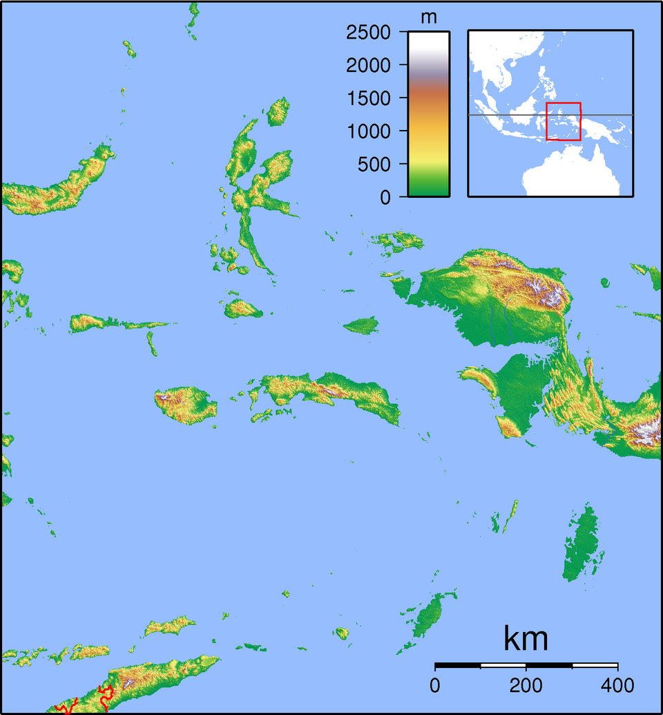
The Moluccan region cover 850,000 square kilometers (328,186 square miles) , of which 90 percent is water and 10 percent of islands. The total land area is roughly 78,897 square kilometers (30,462 square miles ). The highest elevation is 3,027 meters (9931 feet). By one count one there are 1027 islands. The region is divided into two provinces: 1) predominately Muslim North Maluku Province, which stretches from Morotai to Sula, with the capital in Ternate, and 2) Maluku Province, which is roughly evenly divided between Muslims and Christians and encompasses the whole area from Buri to Seram to Wetar.
The Maluku Islands were a single province from Indonesian independence until 1999 when they were split into North Maluku and Maluku. North Maluku province includes Ternate (the former site of the provincial capital), Tidore, Bacan and Halmahera (the largest of the Maluku Islands). Coffee and fruit are important cash crops. Fish and other sea products are Maluku’s major sources of revenue, but nickel, oil, manganese and various kinds of timber also contribute to the province’s wealth. The Moluccas are the original home of nutmeg and cloves, and remain an important producer of spices, along with copra and forest products. Sago is the staple food of the region.
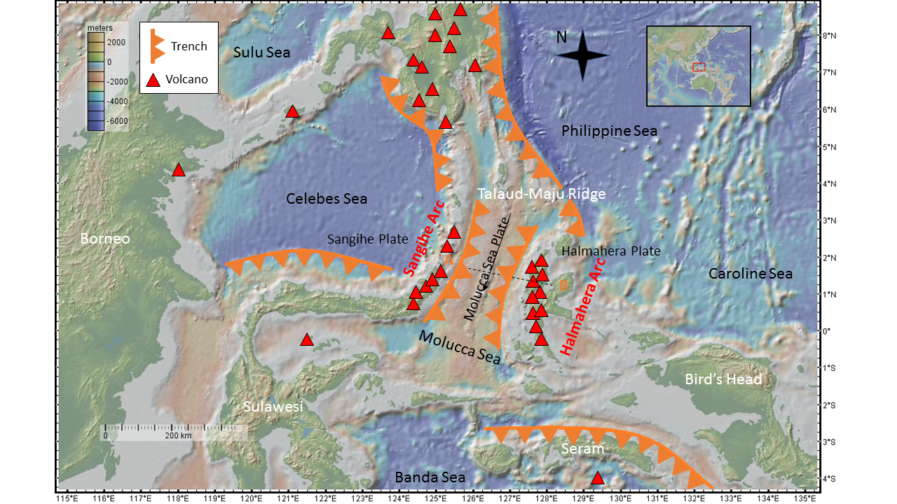
The Moluccas accounts for 3.9 percent of Indonesia's area but only 1 percent of the population Formed largely by volcanic activity, they are mountainous, fertile, and humid. The region lies on a very volatile volcanic belt where there have been over 70 major eruptions in the last 400 years. The geology of the Moluccas shares similar history, characteristics, and processes with the neighbouring Nusa Tenggara region. They comprise some of the most geologically complex and active regions in the world as a result of their position at the meeting point of four geological plates and two continental blocks.
The central and southern Maluku Islands experience the dry monsoon and dry season from October to March and the wet monsoon and wet season from May to August, which is the opposite of the rest of Indonesia. The average maximum temperature during the dry monsoon is 30 °C (86 °F), while the average maximum temperature during the wet monsoon is 23 °C (73 °F). Northern Maluku has its wet monsoon from December to March, in line with the rest of Indonesia. Each island group has its own climate variations, and larger islands tend to have drier coastal lowlands and wetter mountainous hinterlands.
Islands of the Moluccas
The Moluccas archipelago comprises the larger islands of Halmahera, Seram (Ceram) and Buru, as well as the island groups of Sula, Batjan, Obi, Kai, Aru, Tanimbar, Banda, Babar, and Leti. The provincial capital is Ambon is situated on Ambon Island. Halmahera is the largest island, followed by Seram. Seram, Buru, Ambon, Ternate, and Tidore, as well as the Aru and Kai island groups have significant populations.
The Moluccas are sparsely populated, The highest concentrations of people are on Ambon and Ternate. The islands were once largely covered with rain forest but logging and cash crop plantations have resulted in the loss of many of these forests. Some of the islands were once covered by clove and nutmeg plantations. But now many former plantations are worked by subsistence farmers who grow yams and cassava. Banda has only 600 acres of nutmeg trees left.
Three regions are to be distinguished: the North Moluccas, with its sociopolitical center in the small islands of Ternate and Tidore off the west coast of Halmahera; the South Moluccas, with its center in the Banda Islands; and the Central Moluccas, with its center in the island of Ambon and three adjacent small islands off the southwest coast of Seram. Ternate and the adjoining islands were the natural habitat of the clove tree, while the Banda Islands were the natural habitat of the nutmeg tree, producing nutmeg and mace. [Source: Encyclopedia of Western Colonialism since 1450, Thomson Gale, 2007]
Most of the Moluccan islands are geologically young, being from 1 million to 15 million years old, and have never been attached to the larger landmasses. The Maluku islands differ from other areas in Indonesia in that they contain some of the country's smallest islands, coral island reefs scattered in some of the deepest seas in the world.
The Northern Moluccas are the original "Spice Islands," sought out for millennia by foreigners for their cloves. They now form a subdivision of the province of Maluku in the Republic of Indonesia and are home to approximately half a million people spread across Halmahera, the Sula and Obi Islands, Bacan, Morotai, and several smaller islands. Two of these islands, Ternate and Tidore, were home to powerful rival Muslim sultanates in pre-European times. At times, their influence reached as far as the Philippines, Sulawesi, New Guinea, and the islands in the Timor Sea. After a century-long struggle with the Portuguese and Spaniards in the 1500s, the sultanates eventually succumbed to Dutch colonial rule in the 17th century. [Source: “Encyclopedia of World Cultures Volume 5: East/Southeast Asia:” edited by Paul Hockings, 1993 ~]
Volcanic Activity in the Moluccas
Volcanic activity in the Moluccas has been particularly intense in recent years. Between 2024 and early 2026, multiple volcanoes in North Maluku have been in a near-constant state of eruption. These volcanoes rank among the most active in Indonesia and require continuous monitoring by authorities because of frequent ash emissions and, in some cases, lava flows. [Source: Google AI]
Mount Ibu, located in North Halmahera, has been one of the most active volcanoes in the country. In early 2025 alone, it recorded more than 1,000 eruptions. Its activity escalated in May 2024, when its alert status was raised to the highest level (Level IV) after eruptions sent ash columns as high as five kilometers into the atmosphere. As of January 2025, Mount Ibu continued to erupt frequently, producing ash plumes typically ranging from 700 to 1,500 meters. In response, authorities have maintained an exclusion zone extending five to six kilometers from the crater.
Mount Dukono, also in North Halmahera, has remained persistently active. Known for its frequent eruptions, it has required the establishment of permanent hazard zones. Throughout 2025, Mount Dukono continued to emit ash columns reaching up to 1.5 kilometers in height, with ashfall affecting nearby communities and reinforcing the need for ongoing vigilance.
In Central Maluku, Mount Banda Api has also shown signs of unrest. By May 2025, it was placed under Alert Level II due to the potential for continued eruptive activity. While less explosive than some of the North Maluku volcanoes, its location near populated areas makes even moderate activity a concern.
Mount Ruang, situated in the broader North Sulawesi–Maluku region, experienced major explosive eruptions in April 2024. These eruptions caused significant disruptions, underscoring the wider regional impact of volcanic activity beyond the core Maluku Islands.
The effects of these eruptions have been wide-ranging. Authorities have established exclusion zones ranging from three to seven kilometers around active volcanoes to protect communities from lava flows, pyroclastic surges, and heavy ashfall. Volcanic activity has disrupted air travel, forced residents to wear protective masks, and prompted the installation of early-warning systems. In addition, heavy rainfall poses a serious secondary hazard, as it can mix with volcanic debris to create dangerous mudflows, or lahars, a risk that disaster management agencies continue to monitor closely.
Wildlife and Ecology of the Moluccas
The Moluccas are also known for their unique wildlife. The remaining forest contains 31 species of lorikeets and parrots. There are also some cockatoos and birds of paradise as well Australian-style marsupials like cuscus and bandicoots. Biogeographically, all of the islands apart from the Aru group lie in Wallacea, the region between the Sunda Shelf (part of the Asia block), and the Arafura Shelf (part of the Australian block). More specifically, they lie between Weber's Line and Lydekker's Line and thus have a fauna that is rather more Australasian than Asian. Malukan biodiversity and its distribution are affected by various tectonic activities. Because many of the islands are small and divided by deep seas, flora and fauna immigration between islands has been restricted, leading to a high rate of endemic species. [Source: Wikipedia]
The ecology of the Maluku Islands has fascinated naturalists for centuries; Alfred Wallace's book, The Malay Archipelago, was the first significant study of the area's natural history and remains an important resource for studying Indonesian biodiversity. Maluku is the subject of two major historical works of natural history by Georg Eberhard Rumphius: the Herbarium Amboinense and the Amboinsche Rariteitkamer.
Rainforest covered most of northern and central Maluku, which, on the smaller islands has been replaced by plantations, including the region's endemic cloves and nutmeg. The Tanimbar Islands and other southeastern islands are arid and sparsely vegetated, much like nearby Timor.[25] In 1997 the Manusela National Park, and in 2004, the Aketajawe-Lolobata National Park, were established, for the protection of endangered species.
Nocturnal marsupials, such as cuscus and bandicoots, make up the majority of the mammal species and introduced mammals include Malayan civets and feral pigs.Bird species include approximately 100 endemics with the greatest variety on the large islands of Halmahera and Seram. North Maluku has two species of endemic birds of paradise. Uniquely among the Maluku Islands, the Aru Islands have a purely Papuan fauna including kangaroos, cassowaries, and birds of paradise.
Alfred Russel Wallace's Eureka Moment in Ternate
When the 35-year-old naturalist Alfred Russel Wallace arrived in Ternate in January 1858, he had already spent nearly four years exploring the vast island world he called the Malay Archipelago. He travelled thousands of miles by steamer, sailing ship, native boat, horseback and on foot, collecting tens of thousands of specimens—from orangutans and birds of paradise to cuscus and countless beetles. By then, Ternate’s former glory had faded under colonial rule. Wallace rented a dilapidated house surrounded by fruit trees, a short walk from the market on the edge of what is now Ternate City. Although several houses are promoted as the site, it is almost certainly lost. “There were two roads that it could have been along, given the information he gave us,” Wallace scholar John Van Wyhe of the National University of Singapore told the BBC. “There are no houses even half the age they should be.” [Source: Theodora Sutcliffe, BBC, February 25, 2022]
Soon after moving in, Wallace fell seriously ill, probably with malaria. Wracked by alternating chills and fevers, he lay for hours with little to do but think. Isolated, weak, and possibly fearing death beneath the looming volcano, his thoughts turned to the ideas of Thomas Malthus, who had argued that human populations were checked by disease, famine, and war. Wallace realised that the same logic might apply to animals.
His travels across what is now largely Indonesia had already filled his mind with evolutionary puzzles: flying frogs whose swimming toes also enabled gliding, and orangutans that hinted at deep ancestral connections—one of which Wallace had even raised as a pet. Illness, and perhaps the prospect of his own extinction, sharpened these reflections. “Vaguely thinking over the enormous and constant destruction which this implied, it occurred to me to ask the question, why do some die and some live?” he later wrote. “And the answer was clearly, that on the whole, the best fitted live.” In that moment, Wallace grasped natural selection as the mechanism driving evolution.
Once his fever eased, he quickly sketched out his ideas and sent them to Charles Darwin. When the letter reached England on 18 June 1858, it caused Darwin acute anxiety: he had been developing the same theory for nearly 20 years. Acting honourably, Darwin and his colleagues presented both men’s ideas together just two weeks later. “If it hadn’t been for Wallace interrupting Darwin, he’d have carried on and written this big book which probably no one would have read,” Van Wyhe explained. “Then everyone said, ‘Gosh, this is really interesting, can you tell us about your theory?’ That book became On the Origin of Species.” Published in November 1859, it transformed science and challenged religious thought worldwide.
Wallace continued travelling. In 1859, he identified the boundary between Asian and Australian fauna now known as the Wallace Line. He returned to England in 1862 with more than 125,000 specimens, including over 83,000 beetles, and in 1868 published his classic memoir The Malay Archipelago. Living to 90, he wrote widely on subjects from women’s rights to spiritualism, and consistently gave Darwin the credit and respect he believed his colleague deserved.
Weda Bay Nickel Mine and Its Impact on an Uncontacted Tribe
The Weda Bay Industrial Park on Halmahera Island is the world’s largest nickel mine. It is part of a large-scale nickel mining and industrial complex in Central Halmahera Regency, North Maluku, Indonesia. Weda Bay began operations in 2019, with deposits developed by Indonesian company PT Weda Bay Nickel. The firm is majority-owned by Strand Minerals, jointly controlled by French mining group Eramet and China’s Tsingshan.
Nickel is a critical component in electric vehicle batteries, and Indonesia is both the world’s largest producer and home to the largest known nickel reserves. While the government is pushing to expand output, concerns are mounting over the environmental damage and the impact on local communities.
Nickel deposits in the Weda Bay area were first identified in 1996. In 1997, a joint venture was formed between Canada-based Weda Bay Minerals and the Indonesian state mining company Antam, which held a 10 percent stake. In 2006, the French mining company Eramet acquired the Canadian share and announced plans to develop the project. However, due to a downturn in mineral prices, development was suspended in 2013.
Deforestation in the area of the Weda Bay nickel mine and processing centers is threatening an Indigenous community considered to be among the country’s last uncontacted tribes, according to rights groups. Two non-governmental organizations told AFP that mining operations in North Maluku province are endangering the O’Hongana Manyawa people by clearing forests and polluting surrounding waterways. [Source Agnes Anya, AFP, July 16, 2024]
See Separate Article: WEDA BAY — THE WORLDS’S LARGEST NICKEL MINE factsanddetails.com
Image Sources: Wikimedia Commons
Text Sources: Indonesia Tourism website ( indonesia.travel ), Indonesia government websites, UNESCO, Wikipedia, Lonely Planet guides, New York Times, Washington Post, Los Angeles Times, National Geographic, The New Yorker, Bloomberg, Reuters, Associated Press, AFP, Japan News, Yomiuri Shimbun, Compton's Encyclopedia and various books and other publications.
Last updated in January 2026