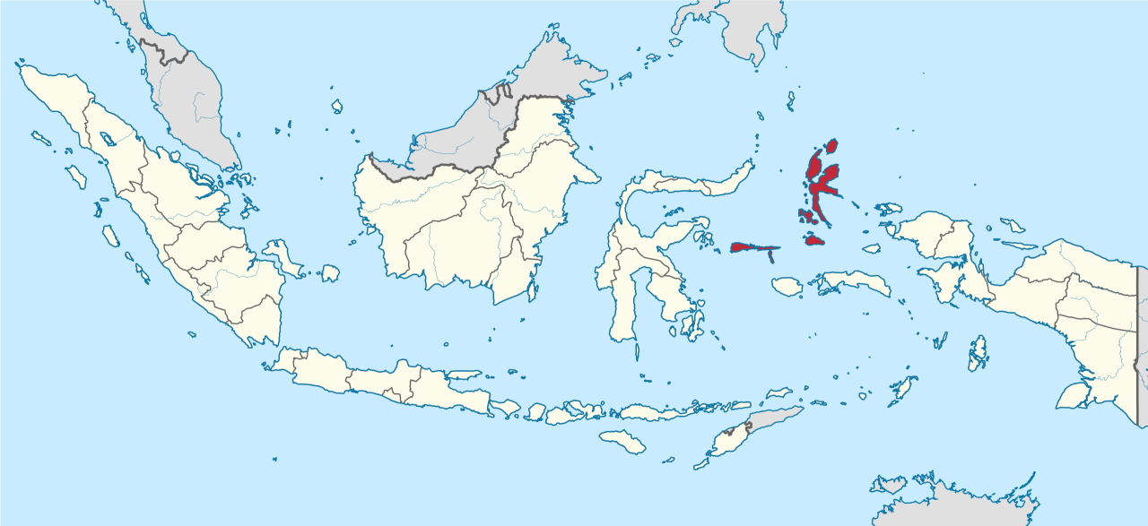
NORTH MALUKA (NORTH MOLUCCAS)
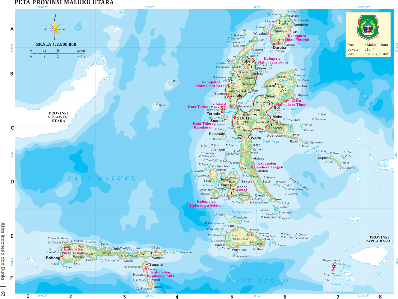
North Maluka (the North Moluccas) embraces Ternate (the former site of the provincial capital), Tidore, Bacan, Halmahera (the largest of the Maluku Islands), the Sula and Obi Islands, Morotai and a number of small islands. Regarded as the original Moluccas, they are the home of cloves the first spice to be sought out by foreign explorers. Up until the 16th century cloves were only produced. here and their trade was controlled by four sultanates of which Ternate and Tidore were the most powerful.
The islands of the North Moluccan people are not really unified in any kind of a way other than that the majority are Muslims and they share a “creole” culture that is the been created by centuries of visitors from foreign lands. Other wise the culture is very diverse. The Tobleroese on Halmahera are Protestant Christians. People on Ternate, Tidore and northern Halmahera speak Papuan languages rather than Indonesian ones. In the interior of Halmahera you can still find some “Alifura” tribal groups. There are a number of active volcanos here. Pulau Makian killed 2,000 people when it erupted in 1970 and caused a full scale evacuation when it began to stir in 1988.
North Maluku Province consists of many small and big islands, approximately 353 of them, which are spread out over a fairly large area of ocean. Many of the islands uninhabited. One such island that has been exploited for tourism is Dodola Island. This island has a 16-kilometer-long white sand beach surrounded by clear water, ideal for swimming, sunbathing and diving. Maitara Island, located in the middle of Tidore and Ternate Islands, is known for its a fantastic sea life. .
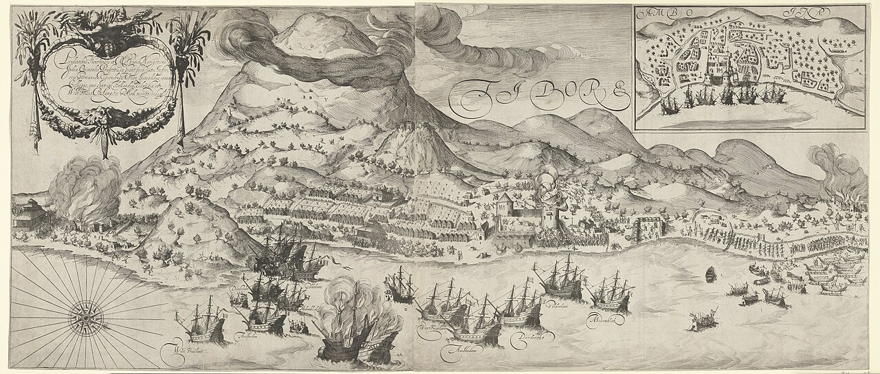
Ternate and Tidore have been visited by foreigners since the 16th century. Each was controlled by a powerful sultan. Both were at the heart of the early spice trade (See The Mollucas). These days spices are still deemed valuable but not much as before. The sultanate still exists and you can view the vast richness of the culture and history in the museum and keraton (castle). Pala (nutmeg) and cengkeh (clove) feature prominently in the cooking and sweets of North Maluka.
The people of North Malaku have mixed blood but mostly Muslims. Since it's dominated by Muslim people, you can find plenty halal food here. Seafood dishes and rice and fish dishes are also abundant. You might want to order cool drinks as well because the weather can be hot.Ternate can be reached by domestic flights from Jakarta via Makassar or direct flight from Makassar and Manado.Tourism Office: Jl. Kamboja No.14 A, Ternate, Tel. (62-921) 326277, 327396
RELATED ARTICLES:
MALUKA (CENTRAL MOLUCCAS) factsanddetails.com
BANDA ISLANDS factsanddetails.com
MOLUCCAS: GEOGRAPHY, ISLANDS, WILDLIFE factsanddetails.com
HISTORY OF THE MOLUCCAS factsanddetails.com
SPICES AND THE SPICE ISLANDS factsanddetails.com;
CLOVES, MACE AND NUTMEG: THE SPICE ISLANDS SPICES factsanddetails.com
DUTCH AND THE SPICE TRADE factsanddetails.com
PEOPLE OF THE MOLUCCAS factsanddetails.com
AMBONESE: HISTORY, IDENTITY, LANGUAGE, RELIGION factsanddetails.com
AMBONESE: LIFE, SOCIETY, FAMILY, FOOD factsanddetails.com
TERNATAN AND TIDORESE factsanddetails.com
TANIMBARESE factsanddetails.com
Halmahera
Halmahera (east of northeast Sulawesi and north of Ambon) is the largest island in the Moluccas and North Maluka. Structured sort of like Sulawesi, is covers 17,780 square kilometers, is comprised of of four mountainous peninsulas and shaped like a Chinese character or a stylized “K.” It is rugged and sparsely populated. People get from place to place by boats that run along the coast rather than on roads across the island. Historically the island has been controlled by Ternate and Tidore and religiously is it occupied mostly by Muslims although there are several area that are predominately Christian.
Halmahera island, also called Gilolo or Jailolo, can reached by speedboat from Ternate and is home to about 450,000 people. Tobelo is the largest town on Halmahera. Sofifi, the capital of the province, is located on the west coast of the island. The sultan’s palace that once existed here is long gone and not even a trace of it remains. On the road to Sidangoli are some black sand beaches and traditional thatch-roof meeting halls. In the mountain forests between Sidangolo and Tobelo are thought to be some rare Wallace’s Standardwing Bird of Paradise, which are hardly ever seen. Danau Galela is the center of a former tourist area that was hit by sectarian violence in the late 1990s. On Morotai Island there are some World War II battle sites. A Japanese soldier hid out here until 1973 not realizing the war was over.
The largest island of Indonesia outside the five main islands, Halmahera lies at the core of a larger region, called Moro that includes the island and the coastline of Halmahera, and is closest to Morotai to the north. Halmahera’s attractions include white sandy beaches, unspoiled forests and the spectacular Mt Mamuya in the distance. Much of the island is still covered in forest.
See Separate Article: HALMAHERA factsanddetails.com
Ternate and Tidore
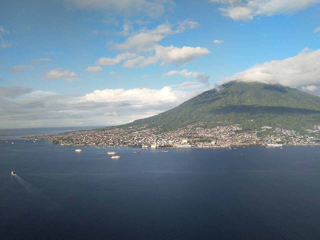
Ternate and Tidore (east of northeast Sulawesi and west of Halamahera) are two almost identical small islands in North Maluka, west of the large island of Halmahera, almost facing one another. Each is around 40 kilometers in circumference and each shaped by a volcano emerging from the deep in Maluku Sea. The volcano on Ternate — Mount Gamalama — is active. The one on Tidore — Mount Kiemtabu — is quiet. There are some ruined Portuguese forts. The people generally live around the coast. See Minorities.
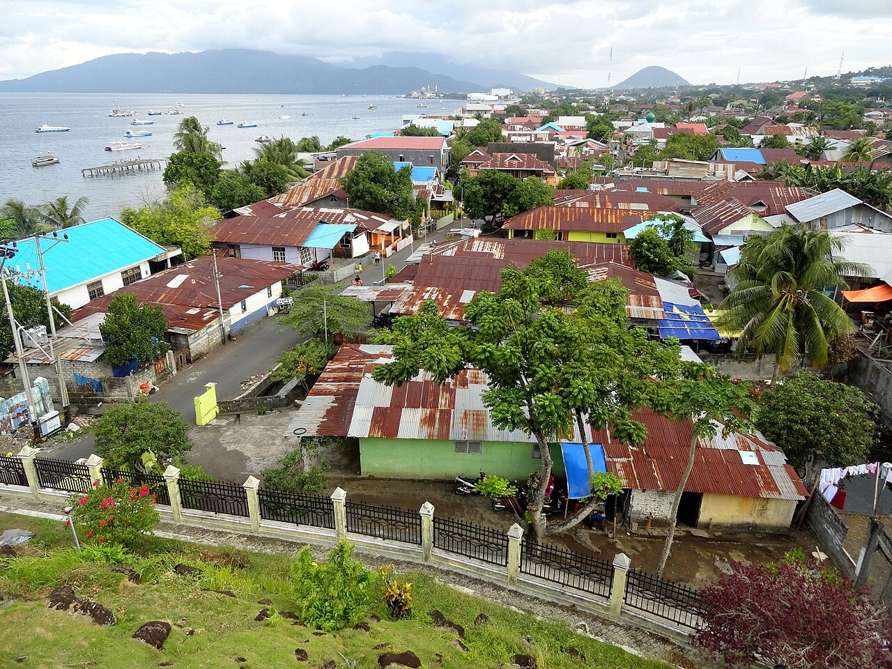
Today, the town of Ternate is the capital city of the province of North Maluku and home to two thirds of the islands’ population, who are predominantly Muslim. Here, you can visit historical relics and observe local cultural traditions. The city is a modern hub and a base for the commercial activities of the island. The city had to rebuild after it sustained severe damage during the 1999 conflict between Muslims and Christians that left dozens dead. In contrast Tidore has no major urban centers and instead is dotted with small villages around the island.
The business district of Ternate is an interesting place to strol around sample the dishes and snacks sold food sellers positioned along the streets. The main street is so long it has five names; Jl Sultan Khairun, Jl Merdeka, Jl Mononutu, Jl Hasan Esa and eventually Jl Raya Bastiong. There are also plans to develop a mega mall. The volcanic landscape of Ternate has given the island its fertile soil and beaches with black sands. There are man picturesque places with colorful boats of various sizes lying in the shallow turquoise water, shaded by swaying coconut trees.
See Separate Articles: TERNATAN AND TIDORESE factsanddetails.com ; MOLUCCAS factsanddetails.com
Accommodation and Restaurants on Ternate
Basic accommodation and losmen are available on Ternate island. These include:
Losmen Pelangi, Jl. Jati Selatan No. 338, Tel. +62 921 22180, 23445
Losmen Kita, Jl. Stadion, Tel. +62 921 21920
Hotel Harmonic, Jl. Kamboja, Tel. +62 921 23861
Losmen Barokah, Jl. Tolukko, Tel. +62 921 23103
Ternate City Hotel, Jl. Nuku Muhajirin, Tel. +62 921 22555, 22777, Fax.+62 921 22630
Losmen Oryza, Jl. Kapitan Pattimura Tanah Masjid, Tel. +62 921 24341
Nauli, Jl. Nuku, Tel. +62 921 21353
Anda Baru, Jl. Kutilang, Tel. +62 921 21262
Crisant, Jl. Ahmad Yani, Tel. +62 921 21288
El Shinta, Jl. Pahlawan Revolusi, Tel. +62 921 22216 — 236
Neraca, Jl. Pahlawan Revolusi, Tel. +62 921 22534
Nirwana, Jl. Pahlawan Revolusi, Tel. +62 921 21787
Ayu Lestari, Jl. Pelabuhan Feri Bastiong, Tel. +62 921 256 10
Indah, Jl. Busoiri, Tel. +62 921 21334
Merdeka, Jl. Merdeka, Tel. +62 921 21120
Nusantara, Jl. Salim Fabanyo, Tel. +62 921 21086
Sejahtera, Jl. Salim Fabanyo, Tel. +62 921 21139
Hotel Puri Azzalia, Jl. Monomutu, Tel. (0921)-21959
Hotel Archie, Jl. Nukila, Tel. (0921)-21197|3110555
Many warungs offer cheap and good value Indonesian food. Visit the street warungs at Dufa-dufa harbor. They offer tasty delicacies in a uniquely Ternate style. The more upmarket eateries are located outside the city in Terau and Ngade. These include: Restoran Floridas, Jl. Raya Ngade / Laguna, Ternate, Maluku Utara, +62 921-3124430
Getting to and Around Ternate and Tidore
Getting Around: The road circling Ternate makes it easily accessible by local transport such as Ojeks (motorbike taxi) or Bemos (minivan public transportation).
Getting There: Babullah Airport on Ternate serves the island with various flights, including: Bela Travel (Jl Bosoiri), Lion Air, Wings Air (Almas Mega Travel; Jl Pattimura), Trigana Air (Archie Travel; Jl Raya Bastiong), Express Air (Jl Stadion), and Merpati (Jl Bosoiri). Garuda Indonesia now flies to Ternate from Jakarta with transit in Manado.
If you wish to travel by boat, the North Maluku shipping hub is located at Ternate, and the PELNI liners harbor at Ahmad Yani port. Sangiang goes around the island of Halmahera but the schedule is irregular so check the schedule at the office of Ahmad Yani port regularly. Nggapulu and Sinabung transit at Ternate from and to Sorong, Papua and Bitung, North Sulawesi. Lambelu connects Ternate and Ambon, stops by Namlea (Buru). This sails eastbound only. Slow boats RM Theodora or Intim Teratai both sail to Manado, North Sulawesi on Saturdays/ Thursdays and to Sanana on Tuesday / Thursday.
Jetties are also available at Bastiong. These connect Ternate and Tidore (Rum) with ferries leaving at 7 am. The ferries also go to Bitung overnight at 10 am on Wednesdays, and 5 pm on Saturdays. Dufa-dufa jetty connects Ternate with speedboat to Halmahera. Kota Baru jetty connects Ternate with speedboat daily to Sofifi, Halmahera. Mesjid Baru, Jati Mall and Swering also connects Ternate with speedboats to Halmahera and Tidore.
Kota Ternate
Kota Ternate (on Ternate island) is the largest and best connected town in the northern Moluccas. Regarded as mor of a collection of villages than a city, it extends for over 10 kilometers on Ternate’s east coast. The sultan’s palace, built in 1796, has been restored. In the museum are collection of the sultan’s possession and Portuguese and Dutch weapons. Sometimes the sultan’s cassowary feather crown is displayed. it is said to have magical powers such as increasing hair growth.
The Kedaton (or Sultan’s Palace) this still serves in part as a family home. The sister of the Sultan provides visitors with information about Ternate and related places of interest in excellent English in the special section of the Kedaton that acts as a museum. To see the crown you need plan ahead and obtain permission from the Sultan. The crown is worn only at coronations. Legend has it that the crown presents ‘growing hair’, which needs regular trimming. The people believe that parading the crown around the island prevents disaster, and has prevented Mount Gamalama from erupting in the past.
Also worth a look are Benteng Orany, a crumbling Dutch fort, built in 1607; Benteng Tolukko, a small womb-shaped fort built by the Portuguese in 1512 and restored by the Dutch in 1610; Benteng Kalamata, a small built by the Portuguese in 1540 and rebuilt by the Dutch in 1610, with walls that reach rich down into the ocean. Danau Tolier Besar is a spectacular crater lake in the north of the island with a resident population of crocodiles.
The Sultan’s Mosque is also an interesting place to visit. Check out the impressive heavy timberwork of the interior. The Benteng Oranye once served as the office of East Indies Company (VOC) and also as the base for the Dutch governor of Ternate. Tolukko Fort was the first fort built in Ternate. Red Wood Fort is also worth visiting for its splendid scenery.
Gamalama: Ternate’s Very Active Volcano
Gunung Api Gamalama (Ternate) is the 1271-meter-high volcano at the center of Ternate. It erupted quite violently in 1840, killing hundreds and destroying nearly every structure on the island. More recently it erupted in 1980, 1983 and 1994. Many visitors hike to the top. Reaching the top takes about five hours and requires a guide. One the way up the hikes pass through clove plantations.
Gamalama is a near-conical stratovolcano and embraces all of Ternate island. in Indonesia. An eruption in 1775 caused the deaths of approximately 1300 people. On December 4, 2011 Mount Gamalama erupted, ejecting material up to 2,000 meters into the air. Thousands of residents in nearby Ternate City fled due to ash and dust particles raining down on the town. On December 27 four people were killed died and dozens were injured by a lahar, a volcanic mud and debris flow, a month after the eruption began. More eruptions occurred in September 2012. An eruption on December 18, 2014, deposited five centimeters of ash on the runway of Babullah Airport in Ternate, closing the airport.
One person posted on Trip Advisor: “beautiful climb. Started about 10 back at 17.00. You need to be in good condition. Path is rather difficult. Much clay. Please take sticks with you and a lot of water. When it is wet or raining wait for another dry day. I slept in B&B Kurnia homestay Ternate. The lady there can help you to find guides. My guides were Ibnu 0812-4249-9387 and Ryan 0821-5418-7013. Good guys. Check If the have food with them and water otherwise you have to feed them.
Another wrote: “climbed up to the mount accompagnied by two local guides - I do not recommend to go alone without help of a local, but you should a) make sure the guide knows what he's doing, b) negotiate a reasonable price (I payed around 35 EUR for both incl. food). You should leave quite early and hopefully you are lucky and have a sunny day, although the weather may change rapidly too. The visit takes you the whole day and you should be prepared... it's all nature, there are no handrails, no steps, only a narrow path that is very steep. The first part crosses plantation forest with clove, nutmeg, mangosteen trees etc., more uphill there is jungle. You should wear proper hiking shoes (although some local climb up in flip flops) There are different paths to reach the summit, divided by kind of "camps" - places to rest. . You should be in good shape cause it is really exhausting to go up. Take enough drinking water and some food with you. Some parts of the path require certain climbing skills, you should be careful because it's slippery. Arrived in top you have either you have a brilliant view of the surrounding or you’re in the clouds. You can walk around and see some small and big craters. Going down is faster but plan enough time to arrive in the lower parts of plantation forest before it is dark.
Tidore
Tidore (near Ternate) has often stood in the shadow of Ternate but is a nice and quieter place to visit. Soasio is the main town and port. There are plans to reconstruct the palace used by the sultan. The town’s museum contains a magical cassowary crown and some royal spittoons and the sultan’ sedan chair. The ruins of the 17th century Spanish fort Benent Tohula lies on a volcanic ridge. The climb up the 1730-meter-high volcano, Gunung Api Keimatabu, is regarded as dangerous. Tidore was largely spared from the sectarian conflict of 1999 across the Maluku Islands.
Tidore Island consists of a large stratovolcano which rises from the seafloor to an elevation of 1,730 m (5,676 ft) above sea level at the conical Mount Kie Matubu on the south end of the island. The northern side of the island contains a caldera, Sabale, with two smaller volcanic cones within it. Soasio is Tidore's capital. It has its own port, Goto, and it lies on the eastern edge of the island. It has a mini bus terminal and a market. The sultan's palace was rebuilt with completion in 2010.
According to the Smithsonian Global Volcanism Program: “The Tidore volcanic complex consists of two dramatically different volcanic structures. The beautifully conical Kiematabu peak on the south end of Tidore Island is the highest volcano of the North Maluku island chain west of Halmahera. The broad, lower Sabale on the north side of the island is a caldera containing two cones. Maitara Island, 1 km off the NW coast, forms another volcanic construct. Tidore was mapped as Holocene by Apandi and Sudana (1980).”
Image Sources: Wikimedia Commons
Text Sources: Indonesia Tourism website ( indonesia.travel ), Indonesia government websites, UNESCO, Wikipedia, Lonely Planet guides, New York Times, Washington Post, Los Angeles Times, National Geographic, The New Yorker, Bloomberg, Reuters, Associated Press, AFP, Japan News, Yomiuri Shimbun, Compton's Encyclopedia and various books and other publications.
Updated in January 2026