FIRST HUMANS IN THE AMAZON

The first known humans to settle the Amazon Basin arrived around 13,000 years ago as part of the mass migration that brought people to all parts of the Americas. "The 'peopling' of South America represents one of the great migrations of human history — but their arrival into the Amazon biome has been little understood," Mark Robinson, associate professor of archaeology at the University of Exeter in the U.K., said in a statement. "For researchers working in the field, dense rainforest makes it challenging to identify potential fieldwork sites, and acidic, clay-based soils impair the preservation of organic remains. Our recent excavations, however, help to fill this gap, not only dating their arrival to much earlier than previously understood, but also providing novel insights into their lives and historical trajectories during the Holocene," the epoch following the last ice age that began 11,700 years ago. [Source: Jennifer Nalewicki, Live Science. February 17, 2024]
Jennifer Nalewicki wrote in Live Science: After coming to what is now Serranía de la Lindosa, an archaeological site on the northern edge of the Colombian Amazon, these early Americans lived in rock shelters, fashioned stone tools, hunted and gathered and created massive displays of rock art, according to a new study, published in the March issue of the journal Quaternary Science Reviews. While it was previously known that this area had been occupied beginning at least 12,600 years ago, as evidenced by the rock art, researchers were able to get a better understanding of how the area was utilized and any instances when it wasn’t occupied at all.
Taima-Taima is an archaeological site near the Atlantic Ocean in northern Venezuela about 20 kilometers east of Santa Ana de Coro, in the Falcón State. It has been dated to about 14,000 years ago and is perhaps older. The site was investigated starting in 1964 by José Cruxent, followed by Alan Bryan, Rodolfo Casamiquela, Ruth Gruhn, and Claudio Ochsenius. It has been cited as evidence for people arriving to South America earlier than previously believed. Cruxent discovered a Notiomastodon pelvic bone that was pierced by a stone spearpoint. Geological and radiocarbon dating of the bone and the spearpoint yielded date of 13,000 years ago. Fossils of Xenorhinotherium (an extinct animal similar to camels), have been found in Taima-Taima. [Source: Wikipedia]
At Taima-Taima, José Cruxent discovered El Jobo projectile points, which are believed to be the earliest such artefacts in South America, going back to perhaps 16,000 years ago. This was a major discovery. The bi-pointed El Jobo points were found in the valley of Pedregal River, and were mostly distributed in north-western Venezuela; from the Gulf of Venezuela to the high mountains and valleys. The population using them were hunter-gatherers that seemed to remain within a certain circumscribed territory.El Jobo points were probably used for hunting large mammals. The Joboid series of points have been grouped into four successive complexes. The earliest was Camare, then Las Lagunas, El Jobo, and Las Casitas. The Camare and Las Lagunas complexes lack stone projectile points. The Camare tool complex has been dated to 22,000-20,000 years ago. El Jobo tool complex has been dated to 16,000-9,000 years ago.
RELATED ARTICLES:
EARLIEST EVIDENCE OF HUMANS TO AMERICA factsanddetails.com ;
WHEN AND HOW THE FIRST HUMANS CAME TO AMERICA: THEORIES AND EVIDENCE factsanddetails.com ;
MIGRATION ROUTE OF THE FIRST HUMANS IN AMERICA factsanddetails.com ;
SINGLE WAVE VS MULTIPLE PULSE THEORY AND MIGRATION OF EARLY PEOPLE TO AMERICA factsanddetails.com ;
FIRST AMERICANS: DNA, ASIA AND ASIANS factsanddetails.com ;
EARLIEST MODERN HUMANS IN WHAT IS NOW ALASKA AND CANADA factsanddetails.com ;
EARLIEST MODERN HUMANS IN WHAT IS NOW THE CONTINENTAL U.S. factsanddetails.com ;
WHITE SANDS 23,000-21,000 YEAR-OLD HUMAN FOOTPRINTS factsanddetails.com ;
CLOVIS PEOPLE: SITES, POINTS, PRE-CLOVIS, MAMMOTHS factsanddetails.com ;
EARLIEST MODERN HUMANS IN SOUTH AMERICA factsanddetails.com ;
EARLIEST MODERN HUMANS IN SOUTHERN SOUTH AMERICA factsanddetails.com ;
SOLUTREAN HYPOTHESIS factsanddetails.com
RECOMMENDED BOOKS:
“Origin: A Genetic History of the Americas” By Jennifer Raff, an associate professor of anthropology at the University of Kansas (Twelve, 2022); Amazon.com;
“First Peoples in a New World: Populating Ice Age America” by David J. Meltzer, an archaeologist and professor of prehistory in the Department of Anthropology at Southern Methodist University in Dallas, (Cambridge University Press, 2021); Amazon.com;
“The Indigenous Paleolithic of the Western Hemisphere” by Paulette F. C. Steeves (2023) Amazon.com;
“First Migrants: Ancient Migration in Global Perspective” by Peter Bellwood Amazon.com;
“Ancestral DNA, Human Origins, and Migrations” by Rene J. Herrera (2018) Amazon.com;
“Who We Are and How We Got Here: Ancient DNA and the New Science of the Human Past” by David Reich (2019) Amazon.com;
“Our Human Story: Where We Come From and How We Evolved” By Louise Humphrey and Chris Stringer, (2018) Amazon.com;
"The Settlement of the Americas: A New Prehistory" by Thomas D. Dillehay ( Basic Books, 2000 Dated) Amazon.com;
”Strangers in a New Land: What Archaeology Reveals About the First Americans”
by J. M. Adovasio, David Pedler (2016) Amazon.com;
“Paleoindian Mammoth and Mastodon Kill Sites of North America by Jason Pentrail (2021) Amazon.com;
“Clovis The First Americans?: by F. Scott Crawford (2012)
Amazon.com;
“Across Atlantic Ice: The Origin of America's Clovis Culture”
by Dennis J. J. Stanford, Bruce A. Bradley, Michael Collins Amazon.com;
“From Kostenki to Clovis: Upper Paleolithic—Paleo-Indian Adaptations (Interdisciplinary Contributions to Archaeology) by Olga Soffer (1993) Amazon.com;
El Abra
El Abra is the name given to an extensive archeological site, located in the valley of the same name in the Amazon region of Colombia has been dated to 12,500 years ago by dating stone, bone and charcoal artifacts. The name El Abra is taken from a large hacienda of that name at the foot of the western portion of the rock formation. The eastern side of the outcropping sandstones is accessible.[Source: Wikipedia]
El Abra is situated in the east of the municipality Zipaquirá. It extends to the westernmost part of Tocancipá in the department of Cundinamarca, Colombia and embraces a series of rock shelters, several hundred meters long, in the north of the Bogotá savanna on the Altiplano Cundiboyacense, Eastern Ranges of the Colombian Andes at an altitude of 2,570 meters (8,430 ft). The rock shelter and cave system is one of the first evidences of human settlement in the Americas, dated at 12,400 years ago ± 160 years. The site was used by the hunter-gatherers.
The first research in the place was conducted in 1967, and the stratigraphy of lithic instruments, bones and vegetal charcoal with radiocarbon dating established the date of the settlement. In the late 1960s, the Indiana University collaborated in a deeper research. In 1970, the Dutch Foundation for the Advancement of Tropical Research (NWO-WOTRO) discovered four new preceramic sites and the analysis of lacustrine sediments allowed a more accurate understanding of the paleoclimate and flora.
El Abra Stadial

Stadials and interstadials are phases dividing the Quaternary period, or the last 2.6 million years. Stadials are periods of colder climate, and interstadials are periods of warmer climate. Associated with advancing and retreating Ice Age glaciers, each Quaternary climate phase is associated with a Marine Isotope Stage (MIS) number, which describes the alternation between warmer and cooler temperatures.
The Fúquene stadial, named after Lake Fúquene, close to the village of the same name, is defined from 15,000 to 12,500 years ago. It is characterized by a cold climate, flora typical of páramo ecosystems, and lithic tools. About 12,500 years ago, a gradual rise of temperature allowed the return of Andean cloud forest and the settlement of many animal species, making hunting easier. Artefacts of this period are called abriense: flint (tool)s, and chopper cores. As the climate was more benign, the cave system was gradually abandoned. [Source: Wikipedia]
The excavations of the Tibitó stadial, near Tocancipá at Tibitó, dated at 11,400 years years ago, show lithic instruments, bone tools and remains of Pleistocene megafauna, such as mastodons (Haplomastodon waringi and Cuvieronius hyodon), American horse (Equus amerhipuus lasallei), and deer (Odocoileus virginianus) with traces of ritual ceremonies.
Dated 11,000 years ago, El Abra stadial is characterized by a new cooling of the climate, recession of the forests and a last period of extending glaciations. From this period the archaeological site of Tequendama in Soacha shows lithic instruments (Tequendamenses tools) with a more smooth manufacture, many of them made with materials brought to this place from the Magdalena River valley, such as quartzite. At Tequendama, evidence for domestication of guinea pigs has been uncovered.
Around 10,000 years years ago, the last glaciation ended and the Andean forests appeared again. The lithic instruments show a rise in recollecting activities, with rodents and vegetables consumed, and lower amounts of large animals hunted. The El Abra caves were abandoned gradually, while other nearby rock shelters like Nemocón and open area settlements as Checua were populated. In Aguazuque, around 5,000 years ago, agriculture was established on elevated terraces, grinding stone instruments can be observed in association with itinerant habits. The abriense type instruments disappear.
13-Kilometer-Long, 12,500-Year-Old Rock Art in the Colombian Amazon
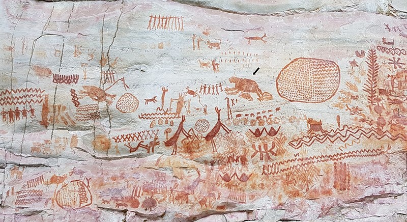
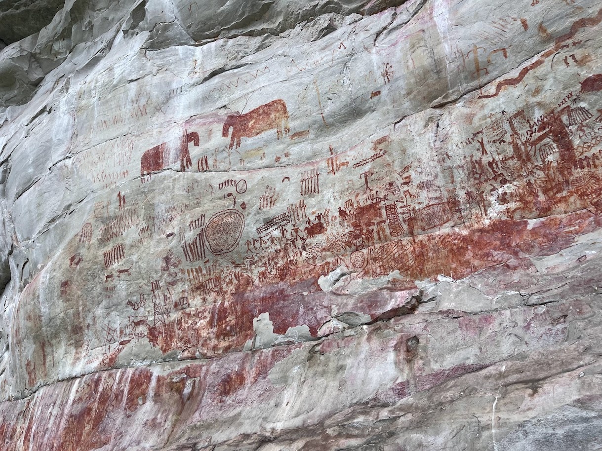
A 13-kilometer (eight-mile) wall of prehistoric rock art featuring images of now extinct animals and some of the first humans in the Americas was discovered by scientists at Serranía La Lindosa, on the northern edge of the Colombian Amazon, on hills above three rock shelters in the Chiribiquete National Parkin the late 2010a Described as the “Sistine Chapel of the ancients”, the 12,500-years-old artwork were uncovered by a British-Colombian team of archaeologists under the leadership of José Iriarte, professor of archaeology at Exeter University. The findings were published in April, 2020 in the journal Quaternary International.
Experts dated the rock art based on the depictions of animals that are now extinct, such as giant land sloths and elephant-like mastodons. The later is known to have inhabited North and Central America about 12,000 years ago. Among other animals portrayed in the rock art are fish, turtles, lizards and birds. Humans are shown dancing and holding hands. The art were first unveiled on a television documentary series called “Jungle Mystery: Lost Kingdoms of the Amazon”. “Ella Al-Shamahi, an explorer and paleoanthropologist who presents the series, called the images “breathtaking” and said the discovery at Serranía de la Lindosa is “so new” that “they haven’t even given it a name yet”.
Serranía La Lindosa
“Professor Iriarte also discussed about how it felt to look at the drawings, as well as the enormity and detail of the site. “When you’re there, your emotions flow … We’re talking about several tens of thousands of paintings. It’s going to take generations to record them … Every turn you do, it’s a new wall of paintings,” he said. “We started seeing animals that are now extinct. The pictures are so natural and so well made that we have few doubts that you’re looking at a horse, for example. The ice-age horse had a wild, heavy face. It’s so detailed, we can even see the horsehair. It’s fascinating,” he said.
“In a series of tweets, Ms Al- Shamahi called the finding “a significant discovery, which seems to not have been known about by science of locals”, adding that “locals often know”. She also added that the discovery portrayed two things: one, “the extent to which indigenous ppl were a part of the Amazon rainforest — it wasn’t some wilderness, they were highly involved in its management”. Two, “the need to conduct scientific discovery in politically unstable places- that is the new frontier of discovery”.
The team first began studying the region in 2014, two years before FARC, a rebel guerrilla group. struck a peace treaty with Colombia's government. The Serranía La Lindosa region falls under FARC territory, and entering safely still requires careful negotiations with the guerilla group, according to The Guardian. After the peace agreement, researchers spearheaded a project known as LastJourney, which aimed to find out when people first settled the Amazon, and what impact their farming and hunting had on the biodiversity of the region. [Source: Laura Geggel, Live Science, December 1, 2020]
According to Business Insider: The region also has many natural hazards. Poisonous snakes and caimans inhabit the area, which is an hours-long journey from the nearest town.“At one point, a large, venomous bushmaster snake blocked the research team's path. They had to walk around it, knowing they were far from any hospital, as the Guardian reported. “You're in the middle of nowhere," Ella Al-Shamahi, an archaeologist who worked with the team on the forthcoming documentary, told The Guardian. But she added that braving the dangers was "100 percent" worth it. [Source: Susie Neilson, Business Insider, December 3, 2020]
Images in the 12,500-Year-Old Rock Art in the Colombian Amazon
The drawings of mastodons, giant sloths and prehistoric humans discovered in the Colombian Amazon rainforest were largely drawn with ochre — a red pigment frequently used as paint in prehistoric art. "These really are incredible images, produced by the earliest people to live in western Amazonia," study co-researcher Mark Robinson, an archaeologist at the University of Exeter, who analyzed the rock art alongside Colombian scientists, said in a statement.[Source: Laura Geggel, Live Science, December 1, 2020]
Laura Geggel wrote in Live Science, Indigenous people likely started painting these images at the archaeological site of Serranía La Lindosa toward the end of the last ice age, about 12,600 to 11,800 years ago. During that time, "the Amazon was still transforming into the tropical forest we recognize today," Robinson said. Rising temperatures changed the Amazon from a patchwork landscape of savannas, thorny scrub and forest into today's leafy tropical rainforest.
The thousands of ice age paintings include both handprints, geometric designs and a wide array of animals, from the "small" — such as deer, tapirs, alligators, bats, monkeys, turtles, serpents and porcupines — to the "large," including camelids, horses and three-toed hoofed mammals with trunks. Other figures depict humans, hunting scenes and images of people interacting with plants, trees and savannah creatures. And, although there is also ice age animal rock art in Central Brazil, the new findings are more detailed and shed light on what these now-extinct species looked like, the researchers said. "The paintings give a vivid and exciting glimpse into the lives of these communities," Robinson said. "It is unbelievable to us today to think they lived among, and hunted, giant herbivores, some which were the size of a small car." Many of South America's large animals went extinct at the end of the last ice age, likely through a combination of human hunting and climate change, the researchers said.
rock art at Serranía La Lindosa
The rock paintings vary in size, and some are so high up on the cliff face that they can only be viewed with drones. Professor Iriarte told The Observer that the depictions of wooden towers with people appearing to bungee jump from them may be a clue as to how the artists reached the highest points on the rock. “It’s interesting to see that many of these large animals appear surrounded by small men with their arms raised, almost worshipping these animals,” he said, when asked about whether the drawings could have a sacred purpose. “For Amazonian people, non-humans like animals and plants have souls, and they communicate and engage with people in cooperative or hostile ways through the rituals and shamanic practices that we see depicted in the rock art.” [Source: Namita Singh, The Independent, November 30, 2020]
Many of the images show unusual levels of detail for such ancient art, according to Iriarte. “The Ice Age horse had a wild, heavy face. It's so detailed, we can even see the horse hair. It's fascinating," hetold The Guardian. The paintings are so numerous that they will likely take many years to study fully. Plus, Jeison Lenis Chaparro-Cárdenas, an anthropologist at the National University of Colombia and member of the research team, told Business Insider that "the vast majority" of cliffs in the region have not yet been fully explored. [Source: Susie Neilson, Business Insider, December 3, 2020]
People Who Made the 12,500-Year-Old Rock Art in the Colombian Amazon
Laura Geggel wrote in Live Science, Excavations within the rock shelters revealed that these camps were some of the earliest human-occupied sites in the Amazon. The paintings and camps offer clues about these early hunter-gatherers' diets; for instance, bone and plant remains indicate that the menu included palm and tree fruits, piranhas, alligators, snakes, frogs, rodents such as paca and capybara, and armadillos, the researchers said. "These rock paintings are spectacular evidence of how humans reconstructed the land, and how they hunted, farmed and fished," Iriarte said in the statement. "It is likely art was a powerful part of culture and a way for people to connect socially." [Source: Laura Geggel, Live Science, December 1, 2020]
Jennifer Nalewicki wrote in Live Science: For a study done in the early 2020s, archaeologists collected soil samples from two rock shelters in the region. The team analyzed the stratigraphy, or layers, of the sediments and found different layers containing stone fragments, charcoal and "high levels of organic matter indicative of food preparation, consumption, and disposal," according to the statement. [Source: Jennifer Nalewicki, Live Science. February 17, 2024]
The analysis showed there were periods when the shelters were completely abandoned — in some cases for more than a millennium at a time. Within the soil, researchers spotted 3,000-year-old ceramics, 2,500-year-old evidence of soil cultivation and 500-year-old traces of maize, according to the study. The analysis also revealed how early the locations were occupied.
"The results firmly establish that the human occupation of Serranía La Lindosa began in the late Pleistocene, about 12,600 years ago, and continued until the 17th century," José Iriarte, professor of archaeology at the University of Exeter, said in the statement. "The exceptional number of rock shelters found in the region with evidence of human habitation suggest that this area was an attractive landscape for forager groups." It was there they could access a lush tropical forest, savannas and rivers to hunt and gather, he added.
rock paintings at Serranía La Lindosa
In addition to the soil samples, archaeologists also unearthed animal bones, plant remains and ochre, which will be analyzed during future research. "Activity patterns, artifact discard, and soil chemistry indicate that both rock shelters were used as domestic spaces through time, as well as sacred locations for the display of highly evocative art," Jo Osborn, a postdoctoral research associate at the University of Exeter, said in the statement. "All of the rock shelters exhibit ochre paintings from the earliest occupations, indicating that those pioneers were also recording and making sense of this new world they encountered."
Colombian Amazon Shelters and Painting Reveal How People Hunted and What They Ate
Tepuye de Cerro Azul is the largest of the rocky, image-covered shelters in the Serranía La Lindosa region of the Colombian Amazon. Studied by a team of researchers led by Jeison Lenis Chaparro-Cárdenas, they cover more than four kilometers (2.5 miles) of rock and were first painted between 12,600 and 11,800 years ago. The drawings depict humans hunting mastodons and images of other extinct animals like Ice Age horses, giant sloths and ancient llamas. [Source: Susie Neilson, Business Insider, December 3, 2020]
"The Amazon was still transforming into the tropical forest we recognise today," Robinson he said. "The paintings give a vivid and exciting glimpse in to the lives of these communities. It is unbelievable to us today to think they lived among, and hunted, giant herbivores, some which were the size of a small car."
Susie Neilson wrote in Business Insider: “In addition to ancient megafauna, the cliff and cave drawings depict alligators, tapirs, monkeys, turtles, serpents, and porcupines. They also include geometric shapes, as well as everyday scenes showing people hunting and interacting with plants and trees. “There are many things and moments of excitement and amazement," Chaparro-Cárdena said. He added that most images revolved around a common theme: "the majesty of the nature that surrounded them and with which they interacted in their daily lives."
The team conducted soil excavations around the rock-art sites to find clues about how the inhabitants scraped clay to extract ochre, a pigment they used to make the drawings. “Those investigations revealed the remains of animals likely eaten by the ancient people, including piranhas, turtles, armadillos, and capybaras, according to Chaparro-Cárdenas. Modern-day inhabitants of the Amazon rainforest still eat many of the animals found at the sites. “This shows a great variety of resources that were used by the inhabitants of the Amazon for more than 12,000 years," Chaparro-Cárdenas said.
Crops Domesticated in Southwest Amazonia 10,850 Years Ago?
Ancient people in Amazonia began cultivating plants and altering forests earlier than previously thought. In 2022, Archaeology magazine reported: New research within the Llanos de Moxos has revealed that people living in Amazonia some 10,850 years ago were also among the earliest in the world to domesticate and cultivate crops. Sediment analysis showed that the region’s inhabitants created thousands of forest islands within the otherwise treeless savannah by dumping food waste, creating fertile patches on which they were able to grow manioc, squash, maize, and other edible plants. [Source: Archaeology magazine, July-August 2020]
Popular Archaeology reported: The remains of domesticated crop plants at an archaeological site in southwest Amazonia supports the idea that this was an important region in the early history of crop cultivation, according to a study published July 25, 2018 in the open-access journal PLOS ONE by Jennifer Watling from the Museum of Archaeology and Ethnology at the University of São Paulo, Brazil and colleagues. [Source: Popular Archaeology, July 25, 2018]
Genetic analysis of plant species has long pointed to the lowlands of southwest Amazonia as a key region in the early history of plant domestication in the Americas, but systematic archaeological evidence to support this has been rare. The new evidence comes from recently-exposed layers of the Teotonio archaeological site, which has been described by researchers as a “microcosm of human occupation of the Upper Madeira [River]” because it preserves a nearly continuous record of human cultures going back approximately 9,000 years.
In this study, Watling and colleagues analyzed the remains of seeds, phytoliths, and other plant materials in the most ancient soils of the site as well as on artifacts used for processing food. They found some of the earliest evidence of cultivated manioc, a crop which geneticists say was domesticated here over 8,000 years ago, as well as squash, beans, and perhaps calathea, and important tree crops such as palms and Brazil nut. They also saw evidence of disturbed forest and a soil type called “Anthropogenic Dark Earths” which both result from human alteration of local environments.
These findings suggest that the people of this region transitioned from early hunter-gatherer lifestyles to cultivating crops before 6,000 years ago, much earlier than previously thought. Along with plant domestication also came the familiar human habit of landscape modification, suggesting that human impact on Amazonian forests in this region goes back many thousands of years. Altogether, these results point to the Upper Madeira as a key locality to explore the earliest days of crop domestication in the New World.
Watling notes: “This discovery at the Teotonio waterfall in Southest Amazonia is some of the oldest evidence for plant cultivation in lowland South America, confirming genetic evidence”. The authors believe that the Teotonio waterfall is what attracted people to this location for over 9,000 years, as it was an extremely rich fishing location and an obligatory stopping point for people traveling by boat on this stretch of the Madeira river. It was the location of a fishing village (the village of Teotonio) until 2011, when residents were forced to move inland ahead of dam construction. The dam submersed the village and the waterfall.
Black Earth study in Nature from nature.com
Farmers Transformed Amazon Thousands of Years Ago
Ancient communities transformed the Amazon thousands of years ago, farming in a way which has had a lasting impact on the rainforest, according to the study “The legacy of 4,500 years of polyculture agroforestry in the eastern Amazon” is published in the journal Nature Plants in 2018. According to Exeter University: Farmers had a more profound effect on the supposedly “untouched” rainforest than previously thought, introducing crops to new areas, boosting the number of edible tree species and using fire to improve the nutrient content of soil, experts have found.The study is the first detailed history of long-term human land use and fire management in this region conducted by archaeologists, paleoecologists, botanists and ecologists. It shows how early Amazon farmers used the land intensively and expanded the types of crops grown, without continuously clearing new areas of the forest for farming when soil nutrients became depleted. [Source: University of Exeter, July 23, 2018]
The research team examined charcoal, pollen and plant remains from soil in archaeological sites and sediments from a nearby lake to trace the history of vegetation and fire in eastern Brazil. This provided evidence that maize, sweet potato, manioc and squash were farmed as early as 4,500 years ago in this part of the Amazon. Farmers increased the amount of food they grew by improving the nutrient content of the soil through burning and the addition of manure and food waste. Fish and turtles from rivers were also a key part of the diets at the time.
The findings explain why forests around current archaeological sites in the Amazon have a higher concentration of edible plants. Dr Yoshi Maezumi, from the University of Exeter, who led the study, said: “People thousands of years ago developed a nutrient rich soil called Amazonian Dark Earths (ADEs). They farmed in a way which involved continuous enrichment and reusing of the soil, rather than expanding the amount of land they clear cut for farming. This was a much more sustainable way of farming.”
The development of ADEs allowed the expansion of maize and other crops, usually only grown near nutrient rich lake and river shores, to be farmed in other areas that generally have very poor soils. This increased the amount of food available for the growing Amazon population at the time.
Dr Maezumi said: “Ancient communities likely did clear some understory trees and weeds for farming, but they maintained a closed canopy forest, enriched in edible plants which could bring them food. This is a very different use of the land to that of today, where large areas of land in the Amazon is cleared and planted for industrial scale grain, soya bean farming and cattle grazing. We hope modern conservationists can learn lessons from indigenous land use in the Amazon to inform management decisions about how to safeguard modern forests.”

Modern village found at Dark Earth site
Professor Jose Iriarte, from the University of Exeter, said: “The work of early farmers in the Amazon has left an enduring legacy. The way indigenous communities managed the land thousands of years ago still shapes modern forest ecosystems. This is important to remember as modern deforestation and agricultural plantations expand across the Amazon Basin, coupled with the intensification of drought severity driven by warming global temperatures.”
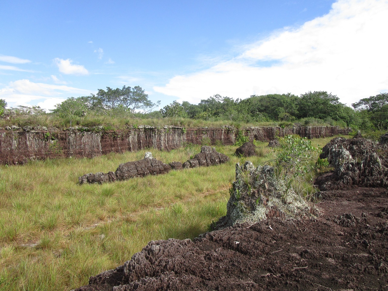
Dark Earth Areas in the Amazon
Thought the Amazon rainforest is incredibly rich in of life, the soil is very poor and this traditionally been given as the reason extensive agriculture never developed there. A paper published in the journal Science Advances in 2013 describes mysterious patches of what is known as “dark earth” in the Amazon rainforest, where the soil is very fertile, nutrient rich, and very good at storing carbon. “When I saw this dark earth and how fertile it was, and started digging into what was known about it, I found it was a mysterious thing — no one really knew where it came from,” Morgan Schmidt, the lead author of the study, said in a press release. [Source: Jackie Appel, Popular Mechanics, September 23, 2023]
According to the University of Exeter; Early inhabitants fertilized the soil with charcoal from fire remains and food waste. Areas with this “dark earth” have a different set of species than the surrounding landscape, contributing to a more diverse ecosystem with a richer collection of plant species, researchers from the State University of Mato Grosso in Brazil and the University of Exeter have found. The legacy of this land management thousands of years ago means there are thousands of these patches of dark earth dotted around the region, most around the size of a small field. This is the first study to measure the difference in vegetation in dark and non-dark earth areas in mature forests across a region spanning a thousand kilometers. [Source: University of Exeter, June 18, 2020]
The team of ecologists and archaeologists studied abandoned areas along the main stem of the Amazon River near Tapajós and in the headwaters of the Xingu River Basin in southern Amazonia. Lead author Dr Edmar Almeida de Oliveira said: “This is an area where dark earth lush forests grow, with colossal trees of different species from the surrounding forest, with more edible fruit trees, such as taperebá and jatobá.”
The number of indigenous communities living in the Amazon collapsed following European colonization of the region, meaning many dark earth areas were abandoned.The study, published in the journal Global Ecology and Biogeography, reveals for the first time the extent to which pre-Columbian Amerindians influenced the current structure and diversity of the Amazon forest of the areas they once farmed.
Researchers sampled around 4,000 trees in southern and eastern Amazonia. Areas with dark earth had a significantly higher pH and more nutrients that improved soil fertility. Pottery shards and other artefacts were also found in the rich dark soils. Professor Ben Hur Marimon Junior, from the State University of Mato Grosso, said: “Pre-Columbian indigenous people, who fertilized the poor soils of the Amazon for at least 5,000 years, have left an impressive legacy, creating the dark earth, or Terras Pretas de Índio”
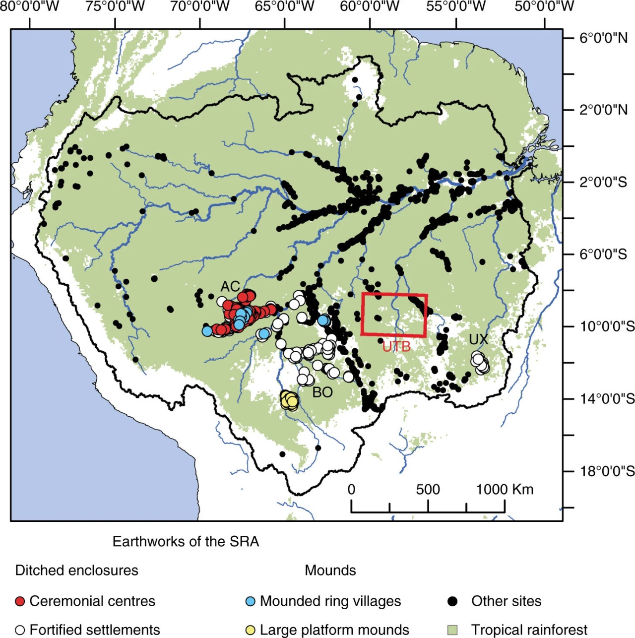
Mound settlements in the Amazon revealed by radar and aerial surveys, with at least some of them associated with Dark Earth plots
Professor José Iriarte, an archaeologist from the University of Exeter, said: “By creating dark earth early inhabitants of the Amazon were able to successfully cultivate the soil for thousands of years in an agroforestry system “We think ancient communities used dark earth areas to grow crops to eat, and adjacent forests without dark earth for agroforestry.”
Dr Ted Feldpausch, from the University of Exeter, who co-authored the study with Dr Luiz Aragão from the National Institute for Space Research (INPE) in Brazil, said: “After being abandoned for hundreds of years, we still find a fingerprint of the ancient land-use in the forests today as a legacy of the pre-Colombian Amazonian population estimated in millions of inhabitants.
Many areas with dark earth are currently cultivated by local and indigenous populations, who have had great success with their food crops. But most are still hidden in the native forest, contributing to increased tree size, carbon stock and regional biodiversity.“Dark earth increases the richness of species, an important consideration for regional biodiversity conservation. These findings highlight the small scale long term legacy of pre Columbian inhabitants on the soils and vegetation of Amazonia,” said co-author Prof Beatriz Marimon, from the State University of Mato Grosso.
How Ancient Amazonians Created Super-Fertile “Dark Earth”
Did the ancient inhabitants of Amazonia cultivate dark earth on purpose, or was it an accidental byproduct of their lifestyle? Jackie Appel wrote in Popular Mechanics: In order to find out, a multi-organizational research team undertook an investigation involving everything from soil analysis to interviews with modern indigenous communities in the region to finally understand how this earth came to be. [Source: Jackie Appel, Popular Mechanics, September 23, 2023]
They started by synthesizing data from years of observations of and interactions with people living in modern Kuikuro villages. This synthesis brought to the forefront various behaviors related to the treatment of the earth that the Kuikuro people would engage in. It specifically highlighted the habitual creation and maintenance of middens — kind of like compost piles filled with “waste and food scraps,” according to a news release — in their and around the centers of villages, which decompose and combine with the rest of the soil in the area to create dark earth. The researchers also noticed that the Kuikuro people spread things like charcoal and ash on fields, which also helps to create dark earth.
Now the goal was to connect the present to the past — could researchers say with reasonable certainty that the ancient predecessors of modern Kuikuro people were also intentionally using these or similar behaviors to create the ancient dark earth? Well, according to a detailed soil analysis, yes they could. The team confirmed that not only was the dark earth found in patterns that were very reminiscent of those the middens form today, the ancient and modern dark earth have very similar compositions. According to a press release, the soil “was enriched in the same elements, such as carbon, phosphorus, and other nutrients.” These elements are known to reduce the aluminum toxicity that plagues much of the soil in the Amazon. “The key bridge between the modern and ancient times is the soil,” Samuel Goldberg, one of the authors on the study, said in a news release. “Because we see this correspondence between the two time periods, we can infer that these practices that we can observe and ask people about today, were also happening in the past.”

Aerial view of the Upano Valley rainforest
2,500-Year-Old Upano Valley Civilization Deep in the Ecuadorian Amazon
The Upano Valley site is arguably the home of the first Amazonanian civilization. Located along a stretch of the eastern Andes, it covered approximately 600 square kilometers (230 square miles) and was occupied from roughly 500 B.C. to sometime between A.D. 300 and 600 archaeological excavations have revealed. It was constructed by members of the pre-Hispanic Kilamope and Upano cultures, two sedentary agrarian societies that once occupied the valley. After a "hiatus," some of the settlements were occupied by the Huapula culture, a study on the site said.. [Source: Jennifer Nalewicki, Live Science, January 12, 2024]
The Upano Valley site is situated in the shadow of a volcano that created rich local soils but also may have led to the destruction of the society. "This is older than any other site we know in the Amazon. We have a Eurocentric view of civilisation, but this shows we have to change our idea about what is culture and civilisation," says Prof Stephen Rostain, director of investigation at the National Centre for Scientific Research in France, who has led the research at the site. "It changes the way we see Amazonian cultures. Most people picture small groups, probably naked, living in huts and clearing land — this shows ancient people lived in complicated urban societies," says co-author Antoine Dorison. [Source: Georgina Rannard, BBC News, January 12, 2024]
Researchers first found evidence of a city in the 1970s Associated Press reported: A series of earthen mounds and buried roads in Ecuador was first noticed more than two decades ago by archaeologist Stéphen Rostain. But at the time, " I wasn’t sure how it all fit together,” said Rostain. Recent mapping by laser-sensor technology (See Below) revealed those sites to be part of a dense network of settlements and connecting roadways, tucked into the forested foothills of the Andes, that lasted about 1,000 years. “It was a lost valley of cities," said Rostain, who directs investigations at France’s National Center for Scientific Research. “It's incredible.” [Source: Christina Larson, Associated Press, January 12, 2024]
The settlements were occupied by the Upano people between around 500 B.C. and 300 to 600 A.D. — a period roughly contemporaneous with the Roman Empire in Europe, the researchers found. While it’s difficult to estimate populations, the site was home to at least 10,000 inhabitants — and perhaps as many as 15,000 or 30,000 at its peak, said archaeologist Antoine Dorison, a study co-author at the same French institute. That's comparable to the estimated population of Roman-era London, then Britain’s largest city. “This shows a very dense occupation and an extremely complicated society,” said University of Florida archeologist Michael Heckenberger, who was not involved in the study. “For the region, it’s really in a class of its own in terms of how early it is.”
According to the BBC: Not a huge amount is known about the people who lived there and what their societies were like. Pits and hearths were found in the platforms, as well as jars, stones to grind plants and burnt seeds. The Kilamope and Upano people living there probably mostly focussed on agriculture. People ate maize and sweet potato, and probably drank "chicha", a type of sweet beer.
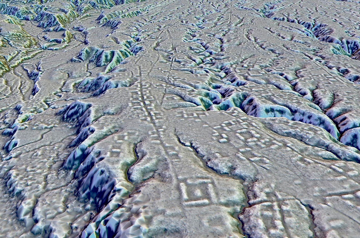
LIDAR map of a part of the Upano site revealing previously undiscovered ruins
Lasers Reveal Extent of 2,500-Year-Old Amazonian Upano Valley Site
Lasers have revealed a complex network of and roadways hidden beneath the canopy of the Amazon. At 2,500 years old, it's the earliest and largest example of an agricultural civilization ever recorded in the Amazon. Jennifer Nalewicki wrote in Live Science” Archaeologists have been studying the Upano Valley site, for several decades. However, it wasn't until they began viewing the Ecuadorian landscape using airborne lidar (light detection and ranging) — in which thousands of infrared laser pulses are reflected repeatedly off the landscape to reveal structures hidden beneath the vegetation — that they realized how elaborate the civilization actually was, according to a study published January 11, 2024 in the journal Science. "I have explored the site many times, but lidar gave me another view of the land," lead study author Stéphen Rostain, an archaeologist and director of research at the French National Center for Scientific Research (CNRS), told Live Science. "On foot you have trees in the way, and it's difficult to see what's actually hidden there."
Lidar images (See Below) showed that the site contained more than 6,000 rectangular earthen platforms, plaza structures and mounds that were interconnected via an extensive gridwork of straight roadways and footpaths. "The streets not only crisscrossed throughout the site but also led outside of the site," Rostain said. "These roadways all functioned together and were used to connect the community." The researchers also discovered groupings of nearly 15 "distinct" settlement sites that ranged in their size and number of structures, according to a statement.
Some of these settlements also had "huge mounds" that stretched up to 492 feet (150 meters) long and stood 26 feet (8 m) high, Rostain said, adding that "it's impressive" how elaborate the site is in both the variety of constructions and the enormity of some of the structures. Based on its sheer size and complexity, the site "resemble[d] similar Maya urban systems in Central America," according to the statement.
According to the BBC: Prof Rostain says he was warned against this research at the start of his career because scientists believed no ancient groups had lived in the Amazon. "But I'm very stubborn, so I did it anyway. Now I must admit I am quite happy to have made such a big discovery," he says. The next step for the researchers is understanding what lies in an adjoining 300 square kilometers (116 square mile) area not yet surveyed.
2,500-Year-Old Upano Valley Roads, Mounds and Infrastructure
At the Upano area surveyed by Lidar residential and ceremonial buildings were erected on more than 6,000 earthen mounds and these were surrounded by agricultural fields with drainage canals. The houses and plazas in the Upano area were connected by an astounding network of roads and canals. The 6,000 rectangular platforms averaged about 20 meters (66 feet) by 10 meters (33 feet) and were two to three meters high. According to the BBC: They were arranged in groups of three to six units around a plaza with a central platform and built by cutting into hills and creating a platform of earth on top.. The scientists believe many were homes, but some were for ceremonial purposes. One complex, at Kilamope, included a 140m (459 feet) by 40 meters (131 feet) platform.

Sangay settlement in Upano area
A network of straight roads and paths connected many of the platforms, including one that extended 25km (16 miles). Dr Dorison said these roads were the most striking part of the research. The largest roads were 33 feet (10 meters) wide and stretched for 6 to 12 miles (10 to 20 kilometers). "The road network is very sophisticated. It extends over a vast distance, everything is connected. And there are right angles, which is very impressive," he says, explaining that it is much harder to build a straight road than one that fits in with the landscape. He believes some had a "very powerful meaning", perhaps linked to a ceremony or belief.
The scientists also identified causeways with ditches on either side which they believe were canals that helped manage the abundant water in the region. There were signs of threats to the cities — some ditches blocked entrances to the settlements, and may be evidence of threats from nearby people. "Imagine that you discovered another civilisation like the Maya, but with completely different architecture, land use, ceramics," says José Iriarte, a professor of archaeology at University of Exeter, who was not involved in this research. Some of the findings are "unique" for South America, he explains, pointing to the octagonal and rectangular platforms arranged together.
The societies were clearly well-organised and interconnected, he says, highlighting the long sunken roads between settlements. Iriarte said it would have required an elaborate system of organized labor to build the roads and thousands of earthen mounds. “The Incas and Mayans built with stone, but people in Amazonia didn’t usually have stone available to build — they built with mud. It’s still an immense amount of labor,” said Iriarte. The Amazon is often thought of as a "pristine wilderness with only small groups of people. But recent discoveries have shown us how much more complex the past really is,” he said. Scientists have recently also found evidence of intricate rainforest societies that predated European contact elsewhere in the Amazon, including in Bolivia and in Brazil. “There’s always been an incredible diversity of people and settlements in the Amazon, not only one way to live,” said Rostain. “We’re just learning more about them.” [Source: Christina Larson, Associated Press, January 12, 2024]
Image Sources: Wikimedia Commons except Sangay settlement by Stephen Rostain and Mound settlement map and Dark Earth images from Nature
Text Sources: National Geographic, Wikipedia, Live Science, Discover magazine, Discovery News, Natural History magazine, Archaeology magazineNew York Times, Washington Post, Los Angeles Times, Smithsonian magazine, Nature, Scientific American, BBC, The Guardian, Reuters, AP, AFP, and various books and other publications.
Last updated June 2024