NORTH BALI
North Bali is the island’s quieter and less-developed region, offering a peaceful alternative to the crowded south. It is known for dramatic volcanic scenery, lush highlands, ancient temples, and a slower pace of life that provides a glimpse into more traditional Balinese culture. With black sand beaches, cool mountain air, and fewer tourists, the area appeals especially to nature lovers seeking tranquility and adventure.
The region is rich in natural beauty. Highlights include scenic waterfalls such as Gitgit, Sekumpul, and Aling-Aling, as well as tranquil lakes like Bratan and Tamblingan. Volcanic mountains and green rice paddies dominate the landscape, while the coastline around Lovina is famous for its distinctive black sand beaches. Inland areas such as Munduk offer cooler temperatures, forested trails, and coffee plantations.
North Bali also features a range of cultural and historical sites. Singaraja, the former colonial capital, reflects the region’s past and remains an important administrative and cultural center. Temples such as Pura Meduwe Karang are noted for their unusual and detailed stone carvings, including a well-known relief depicting a cyclist, which sets it apart from more conventional temple art.
Popular attractions and activities vary across the region. Lovina Beach is best known for early-morning dolphin-watching tours in its calm waters. Munduk serves as a base for trekking and exploring nearby waterfalls. Pemuteran offers a quiet coastal setting ideal for snorkeling and diving, while hot springs such as Air Sanih provide opportunities for relaxation. The nearby Jatiluwih Rice Terraces, a UNESCO World Heritage site, further showcase the area’s agricultural landscape. Reaching North Bali involves a scenic but relatively long drive of about three hours from Ngurah Rai International Airport in Denpasar. Because attractions are spread out, hiring a driver is often the most convenient way to explore the region, whether on a day trip or during a longer stay.
RELATED ARTICLES:
ACTIVITIES IN BALI factsanddetails.com
DENPASAR AND KUTA factsanddetails.com
SANUR AND THE MAIN RESORT AREAS OF BALI factsanddetails.com
UBUD: SIGHTS, MONKEYS, FOOD factsanddetails.com
EAST BALI: MT. AGUNG AND BESALIK TEMPLE factsanddetails.com
WEST BALI AND ITS NATIONAL PARK factsanddetails.com
BEACHES AND DIVING IN NORTH AND WEST BALI factsanddetails.com
BALI: GEOGRAPHY, LIFESTYLE, REPUTATION, GETTING THERE factsanddetails.com
HISTORY OF BALI: ORIGIN, KINGDOMS, MASS ROYAL SUICIDES factsanddetails.com
MODERN HISTORY OF BALI: VOLCANIC ERUPTIONS, TERRORISM, RECOVERY factsanddetails.com
TOURISM IN BALI: CELEBRITIES, RESILIENCE AND ITS RISE FROM A 1930s SOCIALITE ARTIST COLONY factsanddetails.com
BALI BOMBING IN 2002 factsanddetails.com
NEGATIVE SIDE OF TOURISM IN BALI: OVERDEVELOPMENT, BAD BEHAVIOR DONALD TRUMP factsanddetails.com
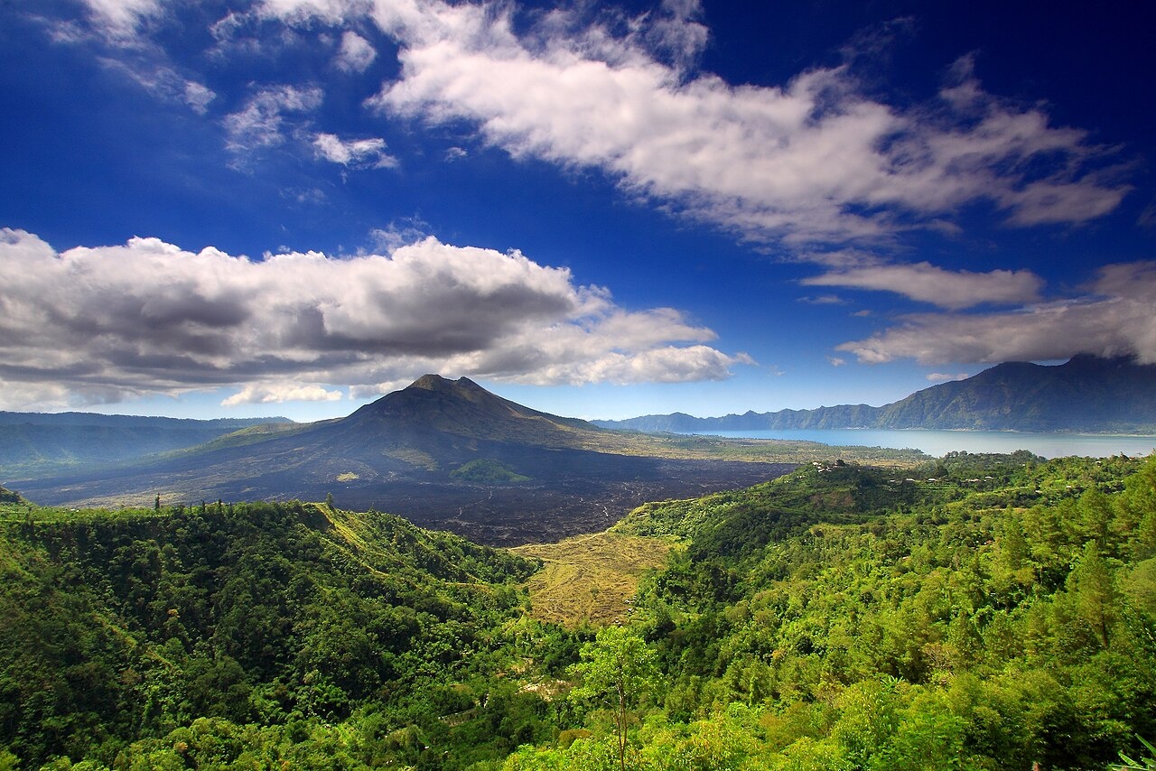
Mt. Batur
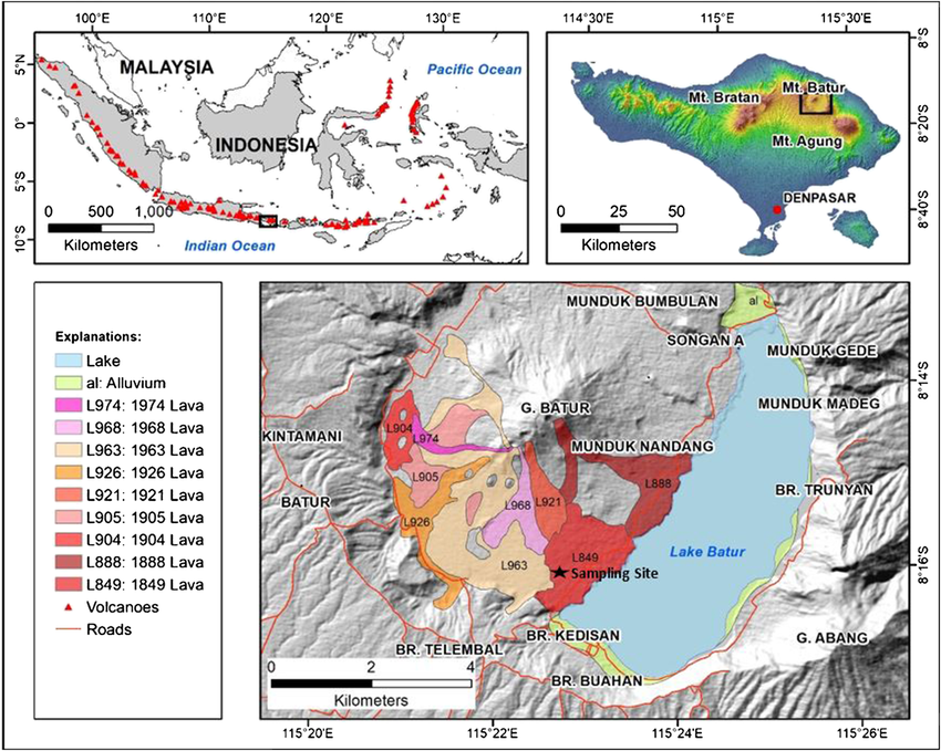
Mt. Batur (40 miles north of Denpasar airport) is a relatively low 5,600-foot-high volcano that can be reached by road. The caldera of the volcano is 14 kilometers in diameter and 100 meters feet deep. Inside the caldera are massive lava flows and Batur Lake, the largest lake in Bali. In 1917, the volcano erupted violently, killing thousands, wiping out the village Batur and leaving more than 60,000 homeless. The eruption left behind the highest cone at 1717 meters. Smaller cones were left behind by eruptions in 1926, 1963, 1974 and 1994.
Most visitors go on organized tours that have lunch at the crater rim at Peneloken. Most of those who stay overnight stay in villages around the lake. There are two roads in the caldera: area: the outer caldera-rim road, linking Penulis and and Penelokan, and the inner-rim road, The latter has some rough sections but is generally drivable by all kinds of vehicles. In the town of Cetacean boats can be rented to cross the lake and visit the "Bali Aga," a group which retains many of the old ways. The hawkers and guides that work this area have a reputation for being as aggressive and pushy as those at Kuta.
The area around Mount Batur and Lake Batur is called Kintamani as is the largest town. It has wonderful mountain views and several important temples The large crescent-shaped Batur Lake is surrounded by the high walls of the crater rim. The sheer size of the crater conjures up images of the massive eruption of the original Mount Batur that occurred tens of thousands years ago. The great eruption of 1917 is described by locals "the year when the world shook" Other eruptions have forced the local population to be relocated, along with several of their temples including one of the main Bali temples, Pura Ulun Danu. Initially inside the huge crater, this temple has been relocated to the top of the ridge overlooking it. Here it now offers an impressive view of Mount Batur.
There is a brilliant view from Penelokan, if its clear. But prepared for wet, cold and cloudy conditions and aggressive souvenir selling. There are several accommodations options ranging from star hotels to homestays in Kintamani. There are many street hawkers selling souvenirs. If you don't want to buy from them, don't make any contact to them otherwise you will be followed until you give up and buy from them. Its better to visit mount and lake Batur in a dry season. During the rainy season is often too foggy and wet
At Penelokan (translated as 'viewing spot') there are several restaurants. On the road going north is a market, busy every three days on Hari Paseh in the Balinese calendar. This is interesting to visit to see the variety of produce from surrounding mountain farms - oranges, corn, vegetable, fruit and the usual vast array of flowers, dried fish, tools, livestock, pots and baskets, plus a big clothing market. You may also see men cuddling big furry Kintamani puppies highly prized all over Bali. You can go to the Batur area by taxi or rental car or motorbike. You can also join a tour to visit Mount Batur and Lake Batur. Tourist shuttle buses between southern Bali and Lovina stop off at Kintamani.
Mt. Batur Hikes and Sights
Hikes to the top of Batur are arranged by the Mount Batur Tour Guides Association which has a post at the trail heads at Toyah Bungkak and Pura Jati. The hike often begins around 4:00am so that hikers can reach the summit and see the sunrise at around 6:30am after sunrise. Clouds often roll in early in the morning and disrupt the view. The most popular trek is from Toya Bungkah to the top of Gunung Batur for sunrise.
The guides charge a fixed price of $50 for the short 4-hour Batur Sunrise hike and $70 for longer six to eight hour Mt. Batur Exploration and Mt. Abang hikes. The fee is a group rate for a maximum of four hikers. Recommended is the five-hour trek up the east face of the mountain, halfway around the rim and down the other side. As a bonus eggs are cooked for breakfast in a boiling fissure on the peak.
The first part of the hike ascends a steep slope with a lot of loose rock. The trail passes steaming hot springs with geyser-like sulfur water fissures and ground that is hot to the touch. From the rim of the crater you can hear the steaming fissures hissing and see steam. The easiest way to reach the summit is drive through Seringga. From the parking lot it is a half hour walk to the summit.
Pura Ulun Danu Batur (near Batur village) is the most important temple in Bali after Besakih, housing more than 90 shrines as well as being its principal water temple (Besakih is mountain-volcano temple). Worth visiting at any time of year, Pura Ulun Danu Batur is especially interesting during the Odalan Festival, usually in March depending on the full moon, which is dedicated to the goddess of the crater lake, who is said to control the irrigation systems for the entire island.
From Toya Bungkah, boats will take you across the lake to a Bali Aga village called Trunyan. This place is known for its unusual mortuary traditions. Instead of cremating the dead, as Balinese do throughout most of the island, the Trunyan communities leave the bodies to decompose naturally in a special cemetery.
Subak System and Tri Hita Karana Philosophy
The Cultural Landscape of Bali Province: the Subak System as a Manifestation of the Tri Hita Karana Philosophy was named UNESCO World Heritage Site in 2012.According to UNESCO: “The cultural landscape of Bali consists of five rice terraces and their water temples that cover 19,500 ha. The temples are the focus of a cooperative water management system of canals and weirs, known as subak, that dates back to the 9th century...The subak reflects the philosophical concept of Tri Hita Karana, which brings together the realms of the spirit, the human world and nature. This philosophy was born of the cultural exchange between Bali and India over the past 2,000 years and has shaped the landscape of Bali. The subak system of democratic and egalitarian farming practices has enabled the Balinese to become the most prolific rice growers in the archipelago despite the challenge of supporting a dense population. [Source: UNESCO]
“A line of volcanoes dominate the landscape of Bali and have provided it with fertile soil which, combined with a wet tropical climate, make it an ideal place for crop cultivation. Water from the rivers has been channelled into canals to irrigate the land, allowing the cultivation of rice on both flat land and mountain terraces. Rice, the water that sustains it, and subak, the cooperative social system that controls the water, have together shaped the landscape over the past thousand years and are an integral part of religious life. Rice is seen as the gift of god, and the subak system is part of temple culture. Water from springs and canals flows through the temples and out onto the rice paddy fields. Water temples are the focus of a cooperative management of water resource by a group of subaks . Since the 11th century the water temple networks have managed the ecology of rice terraces at the scale of whole watersheds. They provide a unique response to the challenge of supporting a dense population on a rugged volcanic island.
“In total Bali has about 1,200 water collectives and between 50 and 400 farmers manage the water supply from one source of water. The property consists of five sites that exemplify the interconnected natural, religious, and cultural components of the traditional su b ak system, where the subak system is still fully functioning, where farmers still grow traditional Balinese rice without the aid of fertilisers or pesticides, and where the landscapes overall are seen to have sacred connotations.
“Subak components are the forests that protect the water supply, terraced paddy landscape, rice fields connected by a system of canals, tunnels and weirs, villages, and temples of varying size and importance that mark either the source of water or its passage through the temple on its way downhill to irrigate subak land...Most subaks possess written legal codes, called awig-awig, which detail the rights and responsibilities of subak membership. Awig-awig, or traditional customary laws and regulations, including subak management and the traditional protection and conservation of cultural properties are covered by regulations of Bali Province Number 5 (2005) Section 19, that clarify zoning for protected sacred sites such as temples, based on local awig-awig . Rice terraces within the sites are also protected against large-scale tourism development by Tabanan Regency Decree No 9/2005.The temples and archaeological sites are currently protected under National Law No.5/1992 concerning Items of Cultural Heritage. The component sites are designed as Strategic Areas which may receive unusual levels of support from the Provincial Government.”
See Subak Systerm Under BALINESE SOCIETY: GROUPS, CASTE, THE SUBAK SYSTEM factsanddetails.com
Subak System Water Temples
The 18th-century Royal Water Temple of Pura Taman Ayun, is the largest and most impressive water temple in Bali. According to UNESCO: “Balinese water temples are unique institutions, which for more than a thousand years have drawn inspiration from several ancient religious traditions, including Saivasiddhanta and Samkhya- Hinduism, Vajrayana Buddhism and Austronesian cosmology. The ceremonies associated with the temples and their role in the practical management of water together crystallise the ideas of the Tri Hita Karana philosophy that promotes the harmonious relationship between the realms of the spirit, the human world and nature....Water temple rituals promote a harmonious relationship between people and their environment through the active engagement of people with ritual concepts that emphasise dependence on the life-sustaining forces of the natural world.
“The sites are the Supreme Water Temple of Pura Ulun Danu Batur on the edge of Lake Batur whose crater lake is regarded as the ultimate origin of every spring and river, the Subak Landscape of the Pakerisan Watershed the oldest known irrigation system in Bali, the Subak Landscape of Catur Angga Batukaru with terraces mentioned in a 10th century inscription making them amongst the oldest in Bali and prime examples of Classical Balinese temple architecture, and the Royal Water temple of Pura Taman Ayun, the largest and most architecturally distinguished regional water temple, exemplifying the fullest expansion of the subak system under the largest Balinese kingdom of the 19th century.
“The cultural tradition that shaped the landscape of Bali, since at least the 12th century, is the ancient philosophical concept of Tri Hita Karana . The congregations of water temples, that underpin the water management of the subak landscape, aim to sustain an harmonious relationship with natural and spiritual world, through an intricate series of rituals, offerings and artistic performances. The five landscapes within Bali are an exceptional testimony to the subak system, a democratic and egalitarian system focused on water temples and the control of irrigation that has shaped the landscape over the past thousand years. Since the 11th century the water temple networks have managed the ecology of rice terraces at the scale of whole watersheds. They provide a unique response to the challenge of supporting a dense population on a rugged volcanic island that is only extant in Bali”
Pura Ulun Danu Batur: Bali’s Principal Water Temples
Pura Ulun Danu Batur (near Batur village) is the most important temple in Bali after Besakih, housing more than 90 shrines as well as being its principal water temple (Besakih is mother-mountain-volcano temple). According to the concept Balinese Rwa Bhineda (The Balance of two opposites), Pura Ulun Danu Batur is regarded as Pradana (feminine) while Pura Besakih is purusha (masculine), thus the two temples complete the universal Balance. Whereas at Pura Besakih, God is worshipped to strengthen the soul of the people to achieve spiritual happiness, at Pura Batur, prayers are conducted to strengthen economic prosperity.
Lying at an altitude of 900 meters above sea level, the temple is located at Kalanganyar Village, Kintamani sub district, Bangli regency, in the heart of Central Bali. Rebuilt in 1926, the temple is dedicated to Dewi Batari Ulun Danu, the goddess of lakes and rivers. "Ulun Danu" itself literally translates as "head of the lake". Until 1917, the Ulun Danu Batur Temple was nestled in the northwestern slope of Mount Batur. The large eruption of Mount Batur in 1917, which swallowed thousands of lives and ruined the entire area, equally sorely damaged the temple. The head of the village and the residents then decided to bring the surviving shrines with them and rebuilt the temple at higher ground in Kalanganyar. In the following 1926 eruption, the entire the Batur village, including the temple, was once again buried by lava. But the 11-tiered meru shrine of Dewi Danu located in the temple compound survived. After the catastrophe not only was the temple rebuilt on higher ground, but the village was also shifted higher.
This temple is the core of all water temples in Central Bali. It is paramount among all water temple systems which has great authority over all irrigation systems that draw water from Lake Batur in Bali’s famed Subak landscape. This unique system, which is a recognized UNESCO World Cultural Heritage, comprises not only the technical aspects of rice cultivation and irrigation but is moreover part and parcel of the social and religious unity on Bali.
Pura Batur comprises nine different temples, containing in total 285 shrines and pavilions dedicated to the gods and goddesses of water, agriculture, holy springs, art, crafts, and more. Pura Penataran Agung Batur, the principal temple, has five main courtyards. Its most dominant shrines are the 11-tiered meru situated in the inner and most sacred courtyard, three 9-tiered merus dedicated to Mount Batur, Mount Abang, and Ida Batara Dalem Waturenggong, the deified king of the Gelgel dynasty who ruled from 1460 to 1550. The eight other temples are Penataran Pura Jati, Pura Tirta Bungkah, Pura Taman Sari, Pura Tirta Mas Mampeh, Pura Sampian Wangi, Pura Gunarali, Pura Padang Sila, and Pura Tuluk Biyu.
Legend has it that in ancient time God Pasupati (Shiva) moved the peak of Mount Mahameru in India and divided this into two parts. He brought one part with his left hand and the other with his right hand. Parts of that taken with his right hand became Mount Agung a throne for his son God Putranjaya (Mahadeva Shiva) and the that in his left hand became Mount Batur, a throne for Dewi Danu, the Goddess of the Lake (the manifestation of Vishnu). This legend made the 2 biggest mountains in Bali as two symbolic elements "of man and woman" (Purasa and Pradana) or two manifestations of the origin of the source; God (Ida Sang Hyang Widhi Wasa).
Pura Ulun Danu Batur Festivals, Transport and Accommodation
Worth visiting at any time of year, Pura Ulun Danu Batur is especially interesting during the Odalan Festival, usually in March depending on the full moon, which is dedicated to the goddess of the crater lake, who is said to control the irrigation systems for the entire island. The Danu Kerthi ceremony that is held every five years, is the ceremony where people offer animal sacrifices by drowning cows, goats, chickens, ducks, and pigs, together with offerings to the lake. The ceremony is held to show gratitude for the fertile soil and prosperous life given, as well as the belief that the ceremony will help create a cosmic balance on earth. Another large ceremony held annually at the Ulun Danu temple is the Ngusaba Kedasa, which commemorates the day the temple location was shifted, and to show gratitude for the blessings given by Dewi Danu, who helped inhabitants survive the catastrophe.
Even though the temple is no longer located at the original site, the charm and the spirit of the temple remain as strong as ever. Also inside the temple compound there is a Buddhist temple where Buddhists from around the island come to pray. During a number of Buddhist holy festivals, such as Chinese New Year, the Barongsai dance is performed in the temple. This shows that high tolerance between different religions continues to exist and is well preserved in Bali.
There are several accommodations you can find around Kintamani area, here are some of them: 1) Arlinas, Toya Bungkah, Tel. +62 366 51165; 2) Lakeview Hotel & Restaurant, Penelokan village, Tel. +62 811 3808011, E mail: info@lakeviewhotelandrestaurant.com ; 3) Batur Lakeside Hut, Kedisan Kintamani, Tel. +62 8070181, E mail: info@baturlakesidehut.com ; 4) Segara Hotel & Restaurant, Kedisan, Tel. +62 366 51136, E mail: hotelsegara@hotmail.com
Get There Located within the Kintamani area, Pura Ulun danu Batur is usually approached from the south with 2 routes in from Ubud (45 minutes), and one each from Besakih (1 hour) and Bangli (30 minutes). There is also an easy way in from the north via a turning off the coast road east of Singaraja (1 hour). All private vehicles pay entry charge to get into the area of Rp 10,000 per person. Keep the ticket as this is valid for the whole Kintamani area, and you may be asked to show it again. From the popular tourist destinations in South Bali, a trip to Kintamani by car will take roughly about 90 minutes.
Kedisan Village, at the foot of Mt. Batur, and Accommodation There
Kedisan (about 2 hours north from Denpasar) is a small rural village nestled at the foot of the Mount Batur at the edge of Lake Batur. It is one of 15 villages in the Kintamani Region. Located between Lake Batur’s shore and the magnificent Mount Batur, Kedisan’s soil is well irrigated by the river and Bali’s famous sudak irrigation system and soil is incredibly fertile due to the volcanic ash. That, combined with the cool mountainous climate makes it the perfect crop-raising terrain. It’s no wonder, therefore, that this region is inhabited largely by those that make a living by farming. Kedisan’s colorful patchwork of agricultural produce includes onions, cabbages, peppers, tomatoes and much more. Some residents of Kedisan also work as fisherman, as Lake Batur is home to quite the abundance of fish. The Kintamani region has been well known since the 9th century, as is proven by various royal edicts engraved on copper plates found throughout Kedisan and the other villages around Lake Batur, such as Trunyan, Songan and Buahan.
Accommodation: 1) Batur Lakeside Hut offers a variety of spacious Balinese-style bungalows, each complete with twin or queen-size beds. Facilities include a swimming pool, a library, a restaurant offering local and international cuisines and a lakeside restaurant for fresh fish specials. Other services include guides up the mountain and to the volcano’s caldera, and transportation to other parts of Bali.
2) Batur Lakeside Hut, Kedisan — Kintamani, Bali, Tel. 62 — 361 — 8070181, Website: http://baturlakesidehut.com ; 3) Segara Hotel is located in Kedisan village at the foot of Mount Batur. It offers 4 standards of rooms, Economic, Standard, Deluxe and Superior. It also organizes several tours around Lake Batur and the surrounding area. 4) Segara Hotel, Kedisan,Kintamani 80652, Tel. 62 — 366 — 51136, Mobile: 62 81338 778696, E mail: hotelsegara@hotmail.com, Website: batur-segarahotel.com ; 5) Surya Hotel in Kedisan Village offers 28 comfortable rooms, each with a private shower and hot water. Other services include trekking guides, tours around the island and free pick-ups and transfers. Rates range from USD10 — 25 and include a free breakfast.
6) Surya Hotel, Kedisan — Kintamani, Bali, Tel. 62 — 366 — 51378, E mail: info@suryahotel.com, Website: suryahotel.com, 7) Windusara Hotel, Jalan Raya KedisanPenelokan, Kintamani, Bail, Tel. 62 0 366 0 52467, E mail: windosarahotel@yahoo.com, Website: windusarahotel.baliklik.com, 8) Baruna Cottages is located in the neighboring village of Buahan, also along the shore of Lake Batur. All rooms are inclusive of a Continental Breakfast, and free pick up from Ubud area. Rates range from 400,000 — 600,000 rupiah per night. Trekking guides and tours around the island are also available; 9) Baruna Cottages, Buahan Village, Kintamani, Tel. 62 — 366 — 51378 Mobile: 62 — 81388 459739, E mail: booking@barunacottages.com, Website: barunacottages.com
Image Sources: Wikimedia Commons, Indonesia Tourism website
Text Sources: Indonesia Tourism website (indonesia.travel), Indonesia government websites, UNESCO, Wikipedia, Lonely Planet guides, New York Times, Washington Post, Los Angeles Times, National Geographic, The New Yorker, Bloomberg, Reuters, Associated Press, AFP, Japan News, Yomiuri Shimbun and various books and other publications.
Last updated in January 2026