
TRAVEL IN ACEH
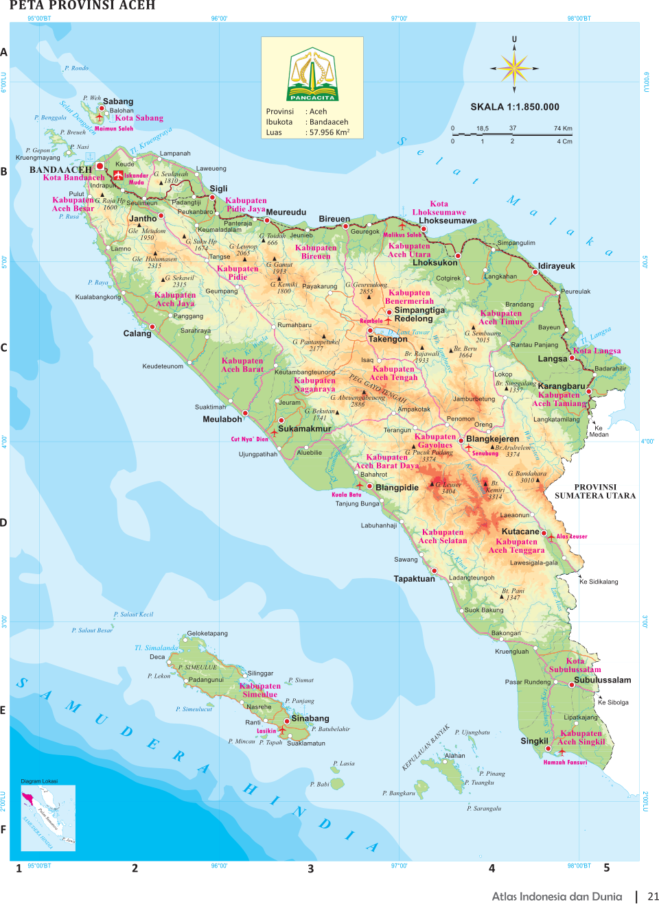
Aceh is the westernmost province of Indonesia and located on the northernmost tip of Sumatra. Home to about 5.5 million people, it contains dense tropical rain forests and jungles, rubber, palm oil and coconut plantations and farms with cocoa trees. It is regarded as the most devoutly Muslim area in Indonesia.
Aceh contains some nice beaches and grows much of the marijuana consumed in Indonesia. It features specular scenery of the Gayo Highlands and provides access to some of the best trekking areas in Gunung Leuser National Park. Political problems, an Islamic insurgency, then the 2004 tsunami and now strict sharia (Islamic law) have prevented the province from reaching its potential as a tourism destination. Malaria is a problem in some places. That doesn’t help tourism either. When you visit dress casually but be sure to respect the locals. The locals are mostly Muslims, and modest clothing is therefore preferred.
Banda Aceh is the capital and largest city of Aceh Province. It is only a forty-five minute flight from Medan. If you depart from Singapore or Kuala Lumpur, it's best if you use a connecting flight to Medan in northern Sumatra and then to Banda Aceh. If you need to depart from Jakarta, the flight will take about two and half hours from its airport, Sukarno Hatta (CGK).
Aceh has largely been rebuilt since the 2004 tsunami. In 2012, the World Bank reported: A visitor to Banda Aceh, the capital of the northernmost province of Indonesia, would marvel at its freshly-painted buildings, well paved roads, and busy shops. Aceh is a transformed place, the result of a lot of money, good organization and hard work. Nearly $7 billion in contributions from the Indonesian government and international donors flowed in, fueling a boom in reconstruction activity. Nearly ten percent of these funds were contributed through the Multi Donor Fund for Aceh and Nias (MDF). The fund, which was managed by the World Bank, pooled funding from 15 donors and provided an effective mechanism for putting these funds to work. The MDF closed its doors at the end of 2012, marking the end of its mandate to support the reconstruction effort. [Source: World Bank, December 26, 2012]
RELATED ARTICLES:
BANDA ACEH: SIGHTS, RESTAURANTS, MEMORIALS OF THE TSUNAMI factsanddetails.com
MEDAN AREA OF NORTH SUMATRA factsanddetails.com
ACEH: GEOGRAPHY, POPULATION, GOVERMENT, RESOURCES factsanddetails.com
ACEH HISTORY: TRADE, ISLAM, KINGDOMS, ESCAPING COLONIALISM factsanddetails.com
ACEH INSURGENCY: GRIEVANCES, GAM, FIGHTING, PEACE factsanddetails.com
ACEHNESE: RELIGION, LANGUAGE, POPULATION, ORIGINS factsanddetails.com
ACEHNESE SOCIETY: FAMILY, MARRIAGE, WOMEN factsanddetails.com
ACEHNESE LIFE: VILLAGES, CUSTOMS, FOOD, CANNABIS factsanddetails.com
ACEHNESE CULTURE: CLOTHES, FOLKLORE, WEAPONS, DANCES factsanddetails.com
DECEMBER 2004 TSUNAMI IN INDONESIA: DAMAGE, VICTIMS AND SURVIVOR STORIES factsanddetails.com
RELIEF AND REBUILDING AFTER THE 2004 TSUNAMI IN INDONESIA factsanddetails.com
SHARIA IN ACEH factsanddetails.com
Banda Aceh

Banda Aceh (nine to 13 hours by bus from Medan on the west side of Sumatra) is the capital of Aceh and the main gateway to the region. It was devastated by the December 2004 tsunami. Most of the city was destroyed, including the Governor's Residence, built by the Dutch. The Baiurrahman Grand Mosque, the most impressive building in the capital, rebuilt in 1875 after being destroyed in the war, was the only landmark building left standing . Banda Aceh was home to 330,000 people before the tsunami. Now it has a population of around 220,000.
Its auspicious position on the tip of the westernmost point of the Indonesian archipelago has made the town of Banda Aceh a recognized transit point as well as a hub for education, commerce, and government. The Aceh Darussalam Kingdom was established by Sultan Johan Syah in 1250AD following the disintegration of old Hindu-Buddha kingdoms like Indra Purba, Indra Purwa, Indra Patra, and Indra Pura. The capital city of the Aceh Darussalam Kingdom was Banda Aceh Darussalam. Following 70 years of battles with the Sultan the Dutch changed the name into Kutaraja. The town was eventually declared Banda Aceh in 1962. As one of the oldest cities that embraces Islam, daily life in Banda Aceh today is still enormously influenced by Islamic lifestyles.
Although around sixty percent of the towns infrastructure was destroyed by the 2004 tsunami and some parts of the city remain permanently submerged, the city is now looking new as considerable developments took place right after the disaster. Infrastructures and activities have resumed as usual, and tourism is becoming increasingly popular as peculiarly fresh attractions spring up to the surface. Ulee Lheue is a shoreline facing Malacca Strait and the Pacific Ocean on the west, and it offers the best sunset views in the country.
See Separate Article: BANDA ACEH: SIGHTS, RESTAURANTS, MEMORIALS OF THE TSUNAMI factsanddetails.com
December 2004 Tsunami in the Banda Aceh Area
Banda Aceh lost around a quarter if its 223,000 people. The main hospital for Aceh, located there, lost 40 percent of its medical staff. Many patients were killed too. The tsunami occurred while the hospital was treating victims from the earthquake. Two islands off the northwestern coast of Aceh broke into four and in the process lost 7,000 of its 11,000 people. The island of Malinggei was completely swept clean of people. After the disaster none of the 500 people that lived there were left. The only large animals were dogs feeding on corpses. Aceh Province as a whole lost about 5 percent of its population of 4 million people. Almost all the deaths were along the coast. A few people living inland were killed by the earthquake.
The tsunami waves that inundated Banda Aceh were a mixture of saltwater, dirt, sewage, garbage and debris. In some places, in 10 minutes a three-meter-high wall of mud, water and debris swept almost 10 kilometers inland. Densely-backed, inhabited water front areas were swept clean, leaving nothing but a few foundations among puddles and ponds. Many of dead that did not drown were thrown against buildings or cut by flowing pieces of tree, wood and metal.
The Los Angeles Times reported: “What had seemed to be a moderate earthquake shook residents of Banda Aceh, a city of about 150,000 at the northern tip of Sumatra, around 8 a.m. local time. About half an hour later, many of them were outside inspecting their houses for damage when, on what had been a clear, sunny day, the sky filled with water. Survivors remembered a sound like the drumbeat of a driving rain. "Water! Water! Big water!" some screamed, unable to articulate the nature of the phenomenon. This was water like nobody had seen — snarling, tall as a four-story building. [Source: Paul Watson, Barbara Demick and Richard Fausset, Los Angeles Times, January 2, 2005]
"It was like Armageddon," remembered Zukarnaen Buyung, a strapping 30-year-old construction worker. "We didn't know it was a wave. We thought it was some kind of rain. Everything behind us was black. The sky, the water." Buyung ran. Little high ground exists in Banda Aceh, which is built along a palm-studded coastal plain, but Buyung managed to scramble up a bridge, dragging his wife and their 2-year-old daughter. They watched, horrified, as the strangely voracious water swallowed up relatives and neighbors. A brother and a nephew disappeared as Buyung looked down, helpless. "I watched. I couldn't do anything," he recalled, his voice choked with grief.
“The tsunami obliterated a swath of the city stretching three miles from the sea. It lifted 75-foot fishing boats and dumped them in the middle of the city, deposited hundreds of bodies in front of what had been brightly lighted shops on Panglima Polem Street. Single-story wooden houses were dismantled as if they were made of sticks, and trees were pulled out like blades of grass. South along Sumatra's long Indian Ocean coastline, entire villages disappeared without a trace.
Diving at Pulai Weh and Places Near Banda Aceh
Nearby Banda Aceh is Kerkhop cemetery where 2000 Dutch soldiers were buried. About 10 miles out of town are nice, uncrowded beaches with white sand and clear blue water. The sunsets are said to be quite good here. When you visit dress casually but be sure to respect the locals. The locals are mostly Muslims, and modest clothing is therefore preferred.
Pulai Weh (just north of Banda Aceh) is lovely island once regarded as the main tourist draw of Aceh. Before the tsunami it boasted some excellent beaches and fine diving and snorkeling spots. The conditions are best in the dry season but whales are often seem in the wet season. Sabang is he main town on the island; Iboih is the most popular beach. Before the tsunami 24,000 people lived in the island. Points of interest include a waterfall, volcano and hot springs, Japanese bunkers from World War II, the historical graveyard, Durian Keramat (sacred Durian) and Sabang town.
Pulai Weh (Weh Island) is relatively untouched despite its small size and convenient access. The westernmost island of the Indonesian archipelago, siituated at the entrance way of the Malacca Strait, it offers blue water and views of tanks and huge freight ships passing through the Strait At dive sites like the fabled Sea Garden in Rubiah Island, manta rays, whale sharks, dolphins and sea turtles are often spotted.
Iboih Beach (opposite the west bank of Pulau Weh) is known locally as Pantai Iboih and also called Teupin Layeu and is located on the left side of the arch on horseshoe-shaped coastline. The town of Iboih, located on Pulau Weh is the most westerly point of Indonesia. Iboih Beach has forests and golden sands strewn with giant boulders. The shallow ocean water is bluish-green and relatively clear. Near the town of Iboih is a large protected forest reserve.
Various accommodations are available. Iboih Beach is frequented by backpackers, world travelers, and divers Some of the guesthouses along the beach is O’ong Guesthouse, Yulia Guesthouse, Erick Guesthouse, Ayub Guesthouse, Anna Bungalow, Fina Bungalow, Fatimah Bungalow, and Mamamia Bungalow.
Gapang Beach is another place in the vicinity of Rubiah Sea Garden.. Among the available accommodations are: Gapang Jaya and Ramadila. Some of the dive operators are: 1) Lumba-lumba Diving Center at lumbalumba.com/divesites.html at Gapang Beach, Weh Island. Call them at +62 652 3324 133 or +62 811 682 787 2. Sumatra Eco-Tourism at sumatraecotourism.com/pulauweh/
Getting There: From Banda Aceh, you can take a ferry in the morning in Ulee Lheue Sea Port and arrive in Gapang Beach. The trip will only take a couple of hours, or 45 minutes if you decide to ride a speedboat. From Banda Aceh, make your way to the Ulue-lue port where you have the options of either a ferry or speedboat to Sabang, on Pulau Weh. The speedboat costs Rp. 50,000 and takes about 45 minutes to get to Sabang Port with departures twice daily. The ferry ride will take around 2 hours and costs Rp. 18,000. When you get to Pulau Weh, you can catch a bemo (minibus) to Iboih which is about 40 minutes away via a picturesque, hilly drive through a number of rustic villages.
Gayo Highlands
Gayo Highlands (13 hours by bus from Medan) is scenic area on the central mountains of Aceh. Inhabited by the the Gayo people, it is an area of coffee and tobacco plantations and forests with monkeys, snakes and a few tigers. The Gayo are farmers, and like the Acehnese, are strict Muslims. The Gayo Highlands are sometimes called the “Countryside above the Clouds.”
The Gayo live predominately in the central highlands of Aceh Province in northwest Sumatra. Also known as the Gajo, Utang Gayo, they have traditionally been rice farmers and traders and have been Muslims since the 17th century. They number about 250,000 with about half them being Gayo speakers. They have traditionally had a strong ethic identity but have been under nominal Aceh suzerainty. Under the Dutch they developed coffee agriculture as cash crop and achieved high levels of education and were involved in the Islamic modernism and Indonesian nationalist movements, participated in the massacres of 1965 and 1966 and were local Suharto and Golkar allies.
In the old days many Gayo lived in longhouses but few of them do anymore. Most of the Gayo that remain in villages live in single family dwellings with palm leaf of corrugated iron roofs. Most farmers raise rice to eat in paddies with water buffalo and grow coffee as a cash crop. Households may consist of nuclear families or extended families, with adolescent boys living in the village prayer house. [Source: Encyclopedia of World Cultures, East and Southeast Asia edited by Paul Hockings (G.K. Hall & Company, 1993) ~]
Gayo society is divided into two kinds of groups: 1) intra-villages kin categories associated with different village offices; and 2) inter village kin categories associated with linkages to common villages somewhere else. Marriages are generally between people no more closely related than third cousins and may or may not involve an exchange of goods. The ceremony involves a ritual exchange goods and speeches. ~
The Gayo have a reputation for being fairly serious Muslims. In the 1920s, there was a movement to rid the religion of animist practices. Even so such beliefs persist in some rural areas. Most religious practices are in line with those of traditional Islam. Important life cycle events include a ritual bath, introduction to the spirit world and naming ceremony seven days after birth, circumcision for boys and girls. In the arts, there is a long tradition if songs, poetry and ritual chanting, often with individuals or teams competing against one another. ~
Takengon
Takengon (in the Gayo Highlands) has a nice cool temperature. The main feature of the town is Lake Lait Tawar which features soaring cliffs that rise up from the shores. There is cave by the lake and hot springs in Simpang Balik and Lyang Koro. Mount Geureundong is passed on the way to Takengon. Takengon is situated at an elevation of 1,200 meters. Year-round, the average temperature is around 20 degree Celsius (68 degree Fahrenheit) with chilly nights and hot afternoons
Takengon is the capital of Central Aceh district and home to about 230,000 people. The food is unique and agro-tourism is promoted in the area. There is fairly good selection of hotels and restaurants and is too far from Medan and Banda Aceh to attract the weekend crowd. Takengon is a quiet place, far different from Banda Aceh. When Banda Aceh becomes merrier as the night comes, the opposite happens in in Takengon.
To get to Takengon from Banda Aceh you can take a bus or a rented car. In some cases, labi-labi (the local public transport in Banda Aceh) can also be rented for a trip to Takengon. It takes 8 hours to get there. From Banda Aceh, a traveler usually passes Bireun, which is an easy drive as the long road is almost straight. From Bireun to Takengon, a driver must pay extra attention to the road as it is winding and gorge is right at the side of the road.
If you depart from Medan, take a bus from bus station going to Banda Aceh, and stop in Lhokseumawe. Medan — Lhokseumawe trip is about 4 hours. From Lhokseumawe to Takengon you can take a minibus and it takes 3 hours to get there. If you happen to be in Kutacane, there is also a public transportation going to Takengon.
Sights and Activities in the Gayo Highlands and Takengon Area
Lake Laut Tawar (meaning “Sea of Fresh Water”) is the most visited attraction in Takengon and is the symbol of the town, followed by the Loyang Putri Pukes Cave. Lake Laut Tawar is rich with trout and fishing is possible. Waterskiing and boating are done in several spots. On the soaring cliffs around the lake some people do rock climbing. Archeologists have found several caves around the lake and they were inhabited 3,500 years ago and discovered stone axes and fossils inside.
Loyang Putri Pukes is a cave featured in the local legend about a girl named Putri Pukes, who was supposed to marry a man from a neighboring village. As she embarked on a new life, she was very sad about leaving Even though her mother told her specifically that ‘you shall not turn your head back to our home as you are heading for your husband’s village’ She failed to follow the warning, and was suddenly turned into stone.
Central Aceh is well known for its flavorsome Arabica coffee production and Takengon is center of the region’s coffee production. Agro-tourism tours and homestays may be arranged at local coffee plantations and pineapple farms. At the coffee plantation, together with its factory in Bener Meriah you can learn how coffee beans are plucked and processed into a product ready for export. Takengon is a center for traditional horse riding. They don’t call their horses by names, but they know how to ride them. Children are taught to ride horse since the earlier age. Go to Pente Menye — Bintang if you are interested horseback riding.
Tapaktuan: on the Indian Ocean in Southwest Aceh
Tapaktuan is a fairly remote and rugged town on the coast of southwest Aceh Province facing the Indian Ocean that has been affectionately dubbed by many foreign tourists as “the prettiest town in Sumatra.” The coast of Tapaktuan is lined with large boulders that are struck by the large waves striking the shore. There are some beautiful white sand beaches but be careful the swimming may be dangerous. Beyond the beaches are a string of high mountains with excellent hiking and views. The sunsets here are particularly beautiful.
Tapaktuan is known as the Dragon City which comes from a legend of the Dragon Princess and Tuan Tapa. The Dragon legend is about a pair of male and female dragons that are believed to inhabit the bay of Tapaktuan. Both had been banished for being unable to produce offsprings. As chance would have it, one day the dragon pair happened upon a baby girl floating in the sea. They took her in and raised her as their own, with the child returning the affection and recognizing them as her parents.
One day, upon the arrival of a royal ship from Asralanoka, His Majesty the King,caught sight of the girl, whom he immediately recognized as his daughter that had been lost at sea 17 years ago. He approached the dragon pair and telling his story asked for the return of his daughter. However, the dragons rejected the request and a fight ensued, which led to disturbing a highly respected hermit residing in a nearby cave. This man was known asTuan Tapa.
Tuan Tapa was bothered by the commotion and immediately attempted to break up the fight between the dragons and the King of Asralanoka. He proceeded to ask the dragons to please return the girl to her rightful parents, which only further angered the dragons who then challenged Tuan Tapa to a fight. Eventually Tuan Tapa defeated the dragon pair and the girl was returned to her parents. She retained the nickname “Dragon Lady”, but the girl and her parents did not return to their homeland, and instead settled down in the coastal zone. Their presence is believed to be the forerunner of Tapaktuan. You can find, scattered along the Tapaktuan beach, many black, heart-shaped rocks (known as Batu Itam), which are believed to be remnants of the dragons’ body, and red stones (Batu Merah) which are said to be the dragons blood.
There is a monument in South Aceh in the shape of a nutmeg (Myristica fragrans Houtt). That's because the nutmeg tree grows naturally in South Aceh. Nutmeg is one of the most popular spices here. It is used to flavor local food, and is used for medicinal purposes as well. Obtained from the distillation of nutmeg, the oil is used for ointments, herbs, and seasonings.
Getting There: Tapaktuan airport is the main gateway to Tapaktuan outside driving along the Trans-Sumatran highway. There are limited flights from Medan (North Sumatra) and Banda Aceh,, with connecting flights from Jakarta and other destinations in Indonesia. Minivans run from Medan (4 hours) and Banda Aceh (6 hours).
Beaches, Sights and Activities in the Tapaktuan Area
The main attractions of Tapaktuan are its beaches. Lawang Beach (20 kilometers north of Tapaktuan) is good for surfing and is known for its massive crashing waves and crystal clear water. The best waves are found between July and November. Tui Lhok Beach (18 kilometers north of Tapaktuan) is very nice quiet beach for swimming, sunbathing, and watching the sunset over the Indian Ocean. For those of you who prefer a fresh water dip, or even those who want to wash away the sea salt, pop over to the waterfall nearby. There is also a pool available there. Pasir Setumpuk Beach is a quiet beach with a large variety of turtles.
If you are looking for some wonderful scenery, you don’t have to far. Bukit Pelita (Pelita Hill) reached by a trail that starts behind the local bus station of Tapaktuan, offers great views of the entire town, the coastline and beaches, and waves and water of the Indian Ocean.
Tingkat Tujuh Waterfall, literally translated, the 7 Story Waterfall, is located approximately 7 kilometers from Tapaktuan. However, 2 kilometers from the waterfall, you will have to continue by foot as the roads are not wide enough for vehicles. This waterfall is appropriately named, being that it makes 7 falls, into a separate pool of its own, one at each level. These fresh, private pools definitely make the short trek worth it!
One site associated with the Dragon legend of Tapaktuan is Makam Tuan Tapa (Mr Tapa's Tomb), located near Bukit Pelita directly in front of the mosque Tuo, at Kampung Padang of Tapaktuan City. Make sure you visit this cemetery to see his grave, which is 10 meters long, about the size of a dragon foot print.
Another exciting excursion is Gua Kalem (“Dark Cave” in the local dialect). Located a few kilometers from Tapaktuan, it is a 50-meter long deep tunnel with a small stream running through it and many small bats. A bit of light seeps in but it is recommended to take a flaghlight. Follow the river upstream, climb over the rocks, and squeeze yourself through the narrow passages to find an amazing little hidden paradise. The fresh clean water is perfect for swimming, sun bathing and there is also an area where you can have a picnic and just relax. There are often monkeys around. If you continue further you will come to Panton Luas, which has a great view over Tapaktuan and the ocean.
If you enjoy jungle treks, there are two places in Tapaktuan which are worth more than at least one visit. Panton Luas, 13 kilometers. north of Tapaktuan, has a dense forest area and a clean river. It is quiet and peaceful with nice views from the mountains. Go to the village and continue for one kilometer up to Gunung Tuan where you can see monkeys and other wild animals.
Gunung Leuser National Park
Gunung Leuser National Park (100 kilometers from Medan reached from Bukit Lawang, Kuatcane or Takengon) is fairly accessible and covers 10,000 square kilometers of swamp forest, lowland rain forests, highland forest and moss forest. The park embraces several peaks over 3000 meters, including 3404-meter-high Gunung Leuser, the highest peak in the park and the source of the park’s name. The best time to visit is from June to October. [Source: Ministry of Tourism and Creative Economy, Republic of Indonesia]
Located in both Aceh and North Sumatra Province, the park is known as Mount Leuser National Park in English and Taman Nasional Gunung Leuser in Bahasa. Most visitors enter the through Bukit Lawang, famous for its orangutans. The largest and the most diverse national parks in Indonesia, it covers an area of 7,927 square kilometers and embraces various ecosystems. The park was created by amalgamating a cluster of nature reserves and forests: Gunung Leuser Nature Reserve, Kappi Nature Reserve, Kluet Nature Reserve, Sikundur-Langkat Wildlife Reserve, Ketambe Research Station, Singkil Barat, and Dolok Sembilin.
Mount Leuser National Park is so extensive, it covers about kind of habitat and ecosystem found in Indonesia: swamp forest, lowland rainforest, moss forest, highland forest, subalpine forest, mangroves, beach and coral reefs. The park encompasses more than 100 kilometers of the Bukit Barisan Mountains, known for their steep, almost inaccessible mountainous terrains. The altitude ranges from beach area in Kluet (South Aceh), to 3,381 meter on top of the Gunung Leuser (Southeast Aceh). The breathtaking Alas River cuts the park into an eastern and western halves and offers thrilling rafting rides.
See Separate Article: RAIN FOREST PARKS OF NORTH SUMATRA factsanddetails.com
Image Sources: Wikimedia Commons
Text Sources: Indonesia Tourism website ( indonesia.travel ), Indonesia government websites, UNESCO, Wikipedia, Lonely Planet guides, New York Times, Washington Post, Los Angeles Times, National Geographic, The New Yorker, Bloomberg, Reuters, Associated Press, AFP, Japan News, Yomiuri Shimbun, Compton's Encyclopedia and various books and other publications.
Last updated in June 2026