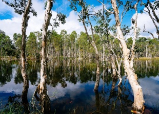
LORENTZ NATIONAL PARK
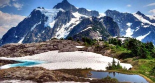
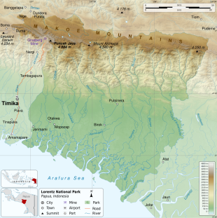
Lorentz National Park is a huge 3.7 million acre chunk of land between the glaciers of Puncak Jaya and the mangrove swamps of the Arafura coast. The park is named after Dutch physicist and explorer H.A. Lorentz. In 1999, Lorentz National Park was named a UNESCO World Heritage Site. According to UNESCO: “Lorentz National Park (2.35 million hectares) is the largest protected area in South-East Asia. It is the only protected area in the world to incorporate a continuous, intact transect from snowcap to tropical marine environment, including extensive lowland wetlands. Located at the meeting-point of two colliding continental plates, the area has a complex geology with ongoing mountain formation as well as major sculpting by glaciation. The area also contains fossil sites which provide evidence of the evolution of life on New Guinea, a high level of endemism and the highest level of biodiversity in the region. [Source: UNESCO]
“Lorentz National Park is located in Indonesia’s Papua Province, along the ‘Pegunungan Mandala’ range, whose Puncak Cartenz (4884 meters) is the highest peak in Southeast Asia. The property covers an area of 2.35 million hectares, making it the largest conservation area in Southeast Asia and stretches for over 150 kilometers from Papua ’s central cordillera mountains in the north to the Arafura Sea in the south.
“Designated as a National Park in 1997 under Decree of the Minister of Forestry the property contains an outstanding range of ecosystems, representative of the high level of biodiversity found across the region. It is one of only three tropical regions in the world that have glaciers and its mosaic of land systems ranges from snow-capped mountain peaks to extensive lowland wetlands and coastal areas. The property also contains fossil sites, a high level of endemism and the richest biodiversity in the region.
“Thirty-four vegetation types and 29 land systems have been identified within the property along with some 123 recorded mammal species, representing 80 percent of the total mammalian fauna of Papua . Mammals recorded include two of the world’s three monotremes; the short-beaked echidna (Tachyglossus aculeatus), and the long-beaked echidna (Zaglossus bruijinii) a New Guinea endemic. In addition it is also home to a large number of restricted range (45) and endemic (9) bird species.
“The property has remarkable, cultural diversity, with eight (and possibly nine) ethnic groups, maintaining their traditional lifestyles. The region has been inhabited for over 24,000 years and has evolved some of the most distinctive and long isolated cultures in the world. The highland, communities include the Amungme (Damal), Dani Barat, Dani Lembah Baliem, Moni and Nduga, whereas in the lowlands there are Asmat, Kamoro and Sempan.”
RELATED ARTICLES:
FREEPORT (GRASBERG) GOLD AND COPPER MINE IN PAPUA, INDONESIA factsanddetails.com
PROBLEMS AT THE FREEPORT MINE: VIOLENCE, POLLUTION, BRIBES, ACCIDENTS factsanddetails.com
UNREST AND LIMITED AUTONOMY IN PAPUA SINCE THE OUSTER OF SUHARTO IN 1998 factsanddetails.com
ETHNIC GROUPS IN SOUTHERN PAPUA (WEST NEW GUINEA) factsanddetails.com
HIGHLAND GROUPS OF WEST NEW GUINEA — EIPO, DAMAL, EKAGI — AND THEIR HISTORY, LIFE AND SOCIETY factsanddetails.com
PAPUA — THE INDONESIA PART OF NEW GUINEA — NAMES, HISTORY, PEOPLE factsanddetails.com
HISTORY OF PAPUA factsanddetails.com
FIRST PEOPLE IN NEW GUINEA ioa.factsanddetails.com
Geology of Lorentz National Park
According to UNESCO: “ The geology and landforms of Lorentz National Park display graphic evidence of earths’ history. Located at the meeting point of two colliding continental plates, the area has a complex geology with ongoing mountain formation as well as major sculpting by glaciation and shoreline accretion. The dominating mountain range is a direct product of the collision between the Australian and Pacific tectonic plates and the property contains the highest points of the mountains of Papua New Guinea and the only remaining glaciers on the island. There is also clear evidence of post glacial shorelines.
Graphically illustrating the geomorphological effect of the last glacial and post-glacial periods, the mountains show all the classical glacial landforms including lakes and moraines. Furthermore, there are five small remnant glaciers. While all five glaciers are retreating rapidly under present climatic conditions, no other tropical glacier fields in the world exhibit glacial evolution as well as those in Lorentz National Park. There is also no better example in the world of the combined effect of collision of tectonic plates and the secondary major sculpting by glacial and post-glacial events.
Ecosystems of Lorentz National Park
According to UNESCO: “National Park is the only protected area in the world that incorporates a continous ecological transect from snow capped mountain peaks to a tropical marine environment, including extensive lowland wetlands. The geophysical processes and high rainfall found along this transect are consistent with the development of significant on-going ecological processes as is the division of the property into two distinct zones: the swampy lowlands and the high mountain area of the central cordillera. The climatic gradient, the greatest throughout the island of New Guinea and the entire Australian tectonic region, extends from nival zones and glaciers to lowland equatorial zones with an associated extreme range of faunal and floral species and communities.Lorentz National Park provides evidence of highly developed endemism in both plants and animals, especially for the higher altitudes of the mountains, as expected in a region combining on-going uplift and climatic warming. [Source: UNESCO]
The park stretches for over 150 kilometers, from Papua's central cordillera mountains in the north to the Arafura Sea in the south. The park can be divided into two very distinct zones: the swampy lowlands and the high mountain area of the central cordillera. The central cordillera itself can be subdivided in the eastern part and the western part on the basis of geology and vegetation types. The central mountain ranges are the southern portion of two colliding continental plates, which are causing the mountain range to rise. The lowering and rising of the sea level during the glacial and interglacial periods of the Pleistocene epoch, along with continuous activity in the mobile belt which characterizes the contact zone of the two colliding lithospheric plates, has continued to promote the great biodiversity of the island of New Guinea in general, and in the Lorentz area in particular. Large tracts of the mountain range and especially the area formed by the traditional lands of the Amungme (or Amung) are rich in mineral deposits, especially gold and copper. The Carstenz/Puncak Jaya section of the Jayawijaya mountain range still retains small ice caps. It is one of only three equatorial of sufficiently high altitude to retain permanent ice. The main snowfields comprise five separate areas of ice on the outer margins of Mount Puncak Jaya. These include two small fields which feed the Meren and Carstenz glaciers and a small hanging glacier on the Carstenz Pyramid.
“Based on physiographic types, five altitudinal vegetation zones have been identified within Lorentz National Park: lowland zone, montane zone, subalpine zone, alpine zone and nival zone; some of the zones are further divided into subzones. The lowland zone comprises the beach subzone covered by vegetation ranging from pioneer herbaceous communities on the first beach ridge to tall mixed forest inland. The tidal swamp subzone comprises one land system, the Kajapah, consisting of intertidal swamps of mangrove and nipah palm. The montane altitudinal zone comprises the Kemum land system, steep-sided deeply dissected mountain ridges. This altitudinal zone is subdivided into lower montane subzone, mid-montane subzone and upper montane subzone. The subalpine zone occurs from 3,200 meters to 4,170 meters.All alpine zones are located above 4,170 meters and consist of alpine peaks with bare rocks and residual ice caps. The lower subalpine forest is floristically poor. The alpine zone lies between 4,170 meters and 4,585 meters.The alpine vegetation includes all communities growing above the tall shrub limits. These are grassland, heath and tundra.
“The mountain building processes that have occurred over time have provided temperate refuges in the tropics for ancient Gondwanan plant species during the climatic warming that has occurred since the last ice age. For example, Lorentz National Park’s Nothofagus beech forests are well represented, although their closest relatives are otherwise confined to the cool temperate regions of south-eastern Australia, New Zealand and the southern Andes. The property is more than just the habitat for many rare, endemic and restricted range species. Its large size and exceptional natural integrity makes it especially important for their on-going evolution as well as thier long term conservation.
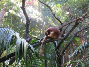
“The refugial effect or local genetic evolution, or both, are manifest as locally endemic species or restricted range species. Much of the rich biota of Lorentz National Park is new or of special interest to science. A number of mammal species, including recent discoveries like the Dingiso tree kangaroo (Dendrolagus mbaiso) discovered in 1994, have evolved to utilize the specialized habitats within the property.”
Animals in Lorentz National Park
According to UNESCO: “Thirty-four vegetation types and 29 land systems have been identified within the property along with some 123 recorded mammal species, representing 80 percent of the total mammalian fauna of Papua . Mammals recorded include two of the world’s three monotremes; the short-beaked echidna (Tachyglossus aculeatus), and the long-beaked echidna (Zaglossus bruijinii) a New Guinea endemic. In addition it is also home to a large number of restricted range (45) and endemic (9) bird species. The property has remarkable, cultural diversity, with seven ethnic groups, maintaining their traditional lifestyles. The highland, communities include the Amungme (Damal), Dani Barat, Dani Lembah Baliem, Moni and Nduga, whereas in the lowlands there are Asmat, Kamoro and Sempan. [Source: UNESCO]
The property covers substantial areas of two identified Endemic Bird Areas (EBAs) with a total of 45 restricted range birds and nine endemic species. Two of the restricted range bird species, Archbold’s bowerbird (Archboldia papuensis), and MacGregor’s bird-of-paradise (Macgregoria pulchra), are considered rare and vulnerable. Mammals recorded within the property include two of the world’s three monotremes; the short-beaked echidna (Tachyglossus aculeatus), and the long-beaked echidna (Zaglossus bruijinii) a New Guinea endemic. Lorentz National Park will become increasingly important for long term conservation of the species already recorded and the many that remain to be discovered.
The species listed below represent a small sample of iconic and/or IUCN Red Listed animals and plants found in the property.
Anas waigiuensis (Anas waigiuensis)
Androphobus viridis (Papuan Whipbird)
Anurophasis monorthonyx (Snow Mountain Quail)
Ardea alba (Great White Egret)
Carettochelys insculpta (Pig-nosed Turtle, Fly River Turtle)
Casuarius casuarius (Southern Cassowary)
Crocodylus porosus (Saltwater crocodile)
Dasyurus albopunctatus (New Guinean Quoll)
Dendrolagus goodfellowi (Goodfellow's Tree-kangaroo)
Esacus giganteus (Beach Stone-curlew)
“In the highlands of Lorentz National Park, six species are endemic to the Snow Mountains; 26 species are endemic to the central Papuan ranges Endemic Bird Area while three species are endemic to the south Papuan lowlands EBA. Globally threatened animal species were found in the lowlands. Vulnerable and threatened birds of the mountains include Salvadori's teal, the snow mountain robin, and Macgregor's bird of paradise. Mammals include two of the world's three monotremes; the short-beaked echidna Tachyglossus aculeatus, a species shared with Australia, and the long-beaked echidna Zaglossus bruijinii, a New Guinea endemic. Mammals also include a range of marsupials including at least four species of cuscus, several species of tree kangaroo and one species of Dasyuridae, often referred to as the 'tiger cat'.
Several threats need to be addressed to ensure the integrity of the park including; development pressures, road construction, boundary demarkation, mining activity, petroleum exploration, illegal logging, impacts from human residents and limited management capacities and resources.
Trekking and Hiking in Lorentz National Park
Despite its huge size, it is very difficult to get into Lorentz National Park. The easiest way is from Wamena, the main Baliem Valley town, to Lake Habbema or Mount Trikora and trekking into the northeast region of the park from there. Although this won’t get you into the heart of the park, there are several indigenous villages in this region and the scenery is spectacular. It takes about two hours driving in a truck or SUV on a very bad road to reach Lorentz National Park from Wanema. It may also require a special permit to pass a military post on the way.
There are many settlements within the park itself, some with airstrips. These are more remote than Wamena though and are difficult and expensive to fly to. For the most part "Lorentz" park exists on paper only, and covers a vast area of disconnected regions. There are really no maintained tourist trails and the like, but as since the park is inhabited, there are many trails connecting villages and their gardens, hunting grounds, etc. Recognized destinations to visit include Puncak Jaya, Gunung Trikora and Danau Habbema, all of which require extra permits to reach. The park is supposed to have an office in Wamena. It is also worth noting that the park is no different from the surrounding areas. In fact, without a map of it, you would never know if you are in the park or not. Very similar or identical looking mountains and forested areas could be seen throughout the highlands.
If you want to approach the park from different direction, take a scheduled flight to Timika then take a perintis flight to one of the remote villages deep inside the park boundaries. According to Roam Indonesia: Susi Air runs semi-regular perintis flights to Alama and Jita lowland villages and the highland villages of Paro and Mapnduma. Trekkers are rare in these parts so in addition to engaging a villager to guide you around the area once you arrive, you should definitely consider taking a guide from Timika with you to help you navigate the language and cultural barriers. As well as your Surat Keterangan Jalan(travel permit) you will need to obtain an additional permit to enter the park. You can get these through the Forestry Conservation Offices in both Wamena and Timika. Above all, remember that Lorentz is extremely remote so trekkers should be well prepared and totally self-sufficient.”
Puncak Jaya: the Highest Mountain in Southeast Asia and Oceania
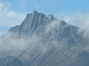
Puncak Jaya, also the Carstensz Pyramid, is the highest peak in Southeast Asia and Oceania at 4,844 meters (16,024 feet) and also by kind of a strange reckoning the highest peak between the Andes and the Himalayas. Even though it is only a few degrees from the equator, it has a permanent glacier. Because it is the highest mountain in Oceania it is one of the peaks that climbers who are climbing the highest mountain in each of the seven continents has to climb.
Puncak Jaya is the highest peak of the mountain called Jayawijaya, also called Mt. Carstensz. Heinrich Harrer, famed author of the book “Seven Years in Tibet,” had always been fascinated by the Jayawijaya Peak in Papua. And so, some 12 years after returning from Tibet in 1950, he and three friends, decided to conquer the peak. In 1962 they became the first climbers to ever reach the top of Puncak Jaya
Many still prefer to call Puncak Jaya by it original name, the Carstensz Pyramid, named after the Dutch explorer Jan Carstensz, who first sighted the snow-capped mountain in 1623. Glaciers growing in equatorial regions are very rare and unfortunately the ones on Puncak Jaya are shrinking . There were significant retreats at several locations of the glaciers on Trikora Peak and the Meren Glacier between 1939 and 1962 and between 1994 to the year 2000. The large eternal ice cap however, remains very awesome and most striking.
The climb to the peak requires special techniques and skills and therefore is recommended only for advanced and intermediate climbers. A climbing company has rated the difficulty at 3 out of 5 difficulty points. The ascent takes fifth class rock climbing ability on an extraordinary limestone summit ridge with Tyrolean Traverse, repelling, and general rope skills.
Getting to and Hiking on Puncak Jaya

Puncak Jaya glaciers are almost gone If you’re not dead set on reaching the summit you can also hike around Puncak Jaya. A hiking route opened by Adventure Indonesia has been considered to be the safest, and securest route, which starts at the villages of Ilaga, Boega, Hoya, Tsinga, and on to some other villages that protect it. Since the Freeport mining area is part of this mountain zone it makes it more grueling to reach the peak. However, this route, known as the Sugapa-Suanggama route, is off the mining site, and is good for hikers and climbers. Following the traditional route, hikers or climbers spend 22 days on foot, interacting with locals enjoying the magnificent scenery, experiencing rough muddy trails and swamps and crossing wooden bridges.
There are a number of companies specializing in guiding climbers to the Jayawijaya. Usually, climbers congregate in Bali and fly to Timika, Papua, and then on to Nabire. Nabire is the closest town to the climbing route. Climbers usually make a detour to visit the Dani in the Baliem Valley on their return trek. Traveling with experienced tour operators or guides is highly recommended. Garuda Indonesia, Kartika, and Merpati have flights into Papua from Jakarta or Denpasar, Bali. Often time, they will make a stop in Makassar before advancing to Sorong, Timika, or Biak, and terminating in Jayapura. Garuda flies from Jakarta to Timika, and Denpasar, Bali to Timika. Going back to Jakarta or Bali, Garuda flies from Timika, Biak, and Jayapura. Lion Air flies from Nabire to Ambon and then to Denpasar, Bali. Check your schedule in airport for individual itinerary. Taking a packaged tour, your flights are usually inclusive in the itinerary. Trigana Air, Susi Air, and Avia Star are flying from Timika to Nabire.
Merauke and Wasur National Park
Merauke (near the Papua New Guinea border in southern Papua ) is the main town in southern Papua. It is a clean, orderly place with a number of places to stay and eat. It is of little interest to travelers other than being an access point to Wasur National Park and Asmat areas.
At each break of day, Merauke is the first town in the Indonesian Archipelago as it lies in the easternmost regency in Indonesia. For travelers, Merauke offers the most facilities such as banks, internet cafes, airline agents, restaurants, markets, and accommodation. A walk around reveal some old graveyards and churches. On a trip down the Maro River one can observe the daily life of Papuan fishermen. An outing to the local market reveals uncommon items and members of ethnic group rarely seen outside of Papau.
Getting There: Garuda Indonesia, Lion Air, and Sriwijaya Air have daily flights to Merauke’s Mopah Airport from Jayapura, Makassar, and Jakarta. Every two weeks Pelni’s (Indonesia Sea Transportation Company) Tatamailau ship sails from Merauke to Agats and Sorong. The Kelimutu ship sails to Agats then sails through southern and Central Maluku, every four weeks.
Wasur National Park (60 kilometers from Merauke) is nearly the size of Everglades National Park in the Florida and embraces similar habitat. It encompasses 4260 square kilometers (one million acres) of savanna, lowland forest, swamp and white-sand beaches. Some 2,500 people live in the park. Most of them are members of Kanum and Marind tribes, people who hunt deer (introduced by the Dutch in the 19th century) and cultivate sago. Some 400 species of bird are found here (60 percent of New Guinea's total), including kookaburras, cassowaries, parrots, pelicans, sandpipers, curlews, brolga cranes, and Papuan frogmouths. Small kangaroos known as wallabies are also often seen. Boat trips, hikes and horseback rides can be arranged. There is observation at Ukra which can bse used for viewing wildlife.
Timika
Timika (west-central Papua ) is the main access point to Freeport gold and copper mine and places deep in the Papua interior. It is expensive. Tours of the mine are no conducted unless you are invited by an employee of Freeport.
Paul Raffaele wrote in Smithsonian Magazine: “I catch a flight across the Banda Sea to the Papuan town of Timika; an American mining company's subsidiary, PT Freeport Indonesia, operates the world's largest copper and gold mine nearby. The Free Papua Movement, which consists of a few hundred rebels equipped with bows and arrows, has been fighting for independence from Indonesia since 1964. Because Indonesia has banned foreign journalists from visiting the province, I entered as a tourist. After a stopover in Timika, our jet climbs above a swampy marsh past the airport and heads toward a high mountain. Beyond the coast, the sheer slopes rise as high as 16,500 feet above sea level and stretch for 400 miles.” [Source: Paul Raffaele, Smithsonian Magazine, September 2006 \=]
The Mozes Kilangin Airport in Timika is served by Garuda Indonesia from Jakarta and Denpasar, and Merpati Nusantara Airlines from the capital of Papua, Jayapura. Susi Air operates flights to local destinations across Papua including from Timika to Ewer. Trigana Air, Susi Air, and Avia Star are flying from Timika to Nabire. Garuda Indonesia, Kartika, and Merpati have flights into Papua from Jakarta or Denpasar, Bali. Often time, they will make a stop in Makassar before advancing to Sorong, Timika, or Biak, and terminating in Jayapura. Garuda flies from Jakarta to Timika, and Denpasar, Bali to Timika. Going back to Jakarta or Bali, Garuda flies from Timika, Biak, and Jayapura. Check your schedule in airport for individual itinerary. Taking a packaged tour, your flights are usually inclusive in the itinerary.
Grasberg Mine (Freeport Mcmoran Gold and Copper Mine)
Grasberg Mine (Freeport Mcmoran Gold and Copper Mine) is the world’s gold mine and world;s second largest copper mine. The world's largest known gold deposit and the world' third largest copper reserves are located on 13,000 foot-high Grasberg Mountain in south central Papua not far from 16,024-foot Puncak Jaya, the highest mountain in Indonesia and Southeast Asia, and the only one between the Andes and the Himalayas that has glaciers. There are also large deposits of silver in the area. [Source: Mark Frankel, Newsweek, December 18, 1995]
The mountain is being mined by Freeport-McMoRan Copper & Gold Inc,—a mining company previously based in New Orleans but now based in Phoenix—through its Indonesian subsidiary PT Freeport Indonesia. The company is often simply called Freeport As of the mid 1990s the company had spent $3 billion to develop the mine and extract its minerals and was the largest single American investor in Indonesia, with a market capitalization of $5 billion, and the country's most profitable business, making more than $1 million a day.
The mine employs just over 24,000 contract and non-contract workers, with a union representing about 18,000 of the workers. Freeport Indonesia said it expected production to reach 1.1 billion pounds of copper and 1.2 million ounces of gold in 2013, up 54 percent and 31 percent over 2012 figures, respectively, as mining moves into higher ore grades. [Source: Michael Taylor, Reuters, May 14, 2013]
The mine began production in the 1970s in the early years of the U.S.-backed Suharto dictatorship. Freeport has access to nine million acres of land, an area one and half times the size of Vermont. About 1.24 million acres is taken up by the mine. The operation is also one of the worlds largest copper mines. As of 2009, Freeport workers numbers around 20,000 excluding on site family members. In 1995 the 60,000 people linked with the mine—employees and their families— lived on a compound carved out of the jungle with American-style shopping centers.
The mine straddles a mineral-rich ridge of peaks pushed up by a collision between the Pacific and Australian tectonic plates. In the 1990s, everyday about $7.2 million worth of gold, copper and silver was extracted from the Grasberg mine. The refined metal harvested every year at that time was worth about $2 billion. The total deposit, one of the world's richest, is worth at least $100 billion. The mine has proven reserves of 46 million ounces of gold, according to the company's 2004 annual report. In 2005, Mining International, a trade journal, called Freeport's gold mine the biggest in the world.
See Separate Articles: FREEPORT (GRASBERG) GOLD AND COPPER MINE IN PAPUA, INDONESIA factsanddetails.com PROBLEMS AT THE FREEPORT MINE: VIOLENCE, POLLUTION, BRIBES, ACCIDENTS factsanddetails.com
Kuala Kecana and Copper Town
Kuala Kecana (near the Grasberg Mine) in south central Papua not far from 16,024-foot Puncak Jaya,is main center for the Freeport McMoRan gold and copper mine. Tembagapura, or "Copper Town" is home ot many of the mine’s employees. Located halfway up the mountain and identified with a sign that bears the Freeport logo, it features air-conditioned markets with a wide variety of American goods and modern apartments and recreation facilities.
Jane Perlez and Raymond Bonner wrote in the New York Times, “Papua's extreme remoteness and the company's long ties to the Indonesian government have given Freeport exceptional sway over a 21st-century version of the old company town, built on a scale unique even by the standards of modern mega-mining. "If any operation like this was put forward now, it wouldn't be allowed," said Witoro Soelarno, a senior investigator at the Department of Energy and Mineral Resources, who has visited the mine many times. "But now the operation exists, and many people depend on it." [Source: Jane Perlez and Raymond Bonner, New York Times, December 27, 2005 -]
“Near Tembagapura on the plains below the mountain is Timika, an ugly town full of prostitutes, bars, gambling halls and people in ragged jeans and T-shirts. It is occupied mainly by poor Papuans who have come to the area to seek work. The Indonesian police and military have a strong presence here. Before the arrival of the mine the plains around Timika was unpopulated. In the 1990s it had 30,000 people, a Sheraton hotel and an airport. By the mid 2000s, there were 100,000 people there.
“The Aghawagon Valley and the area around the Freeport mine is the homeland of Amungmen people. Since the opening of the mine they have gotten in disputes with the more numerous Dani migrants, who have come to the area looking for work. In the 1990s nine people were killed in one altercation. “
Image Sources: Wikimedia Commons, Indonesia Tourism
Text Sources: Indonesia Tourism website ( indonesia.travel ), Indonesia government websites, UNESCO, Wikipedia, Lonely Planet guides, New York Times, Washington Post, Los Angeles Times, National Geographic, The New Yorker, Bloomberg, Reuters, Associated Press, AFP, Japan News, Yomiuri Shimbun, Compton's Encyclopedia and various books and other publications.
Updated in December 2025

