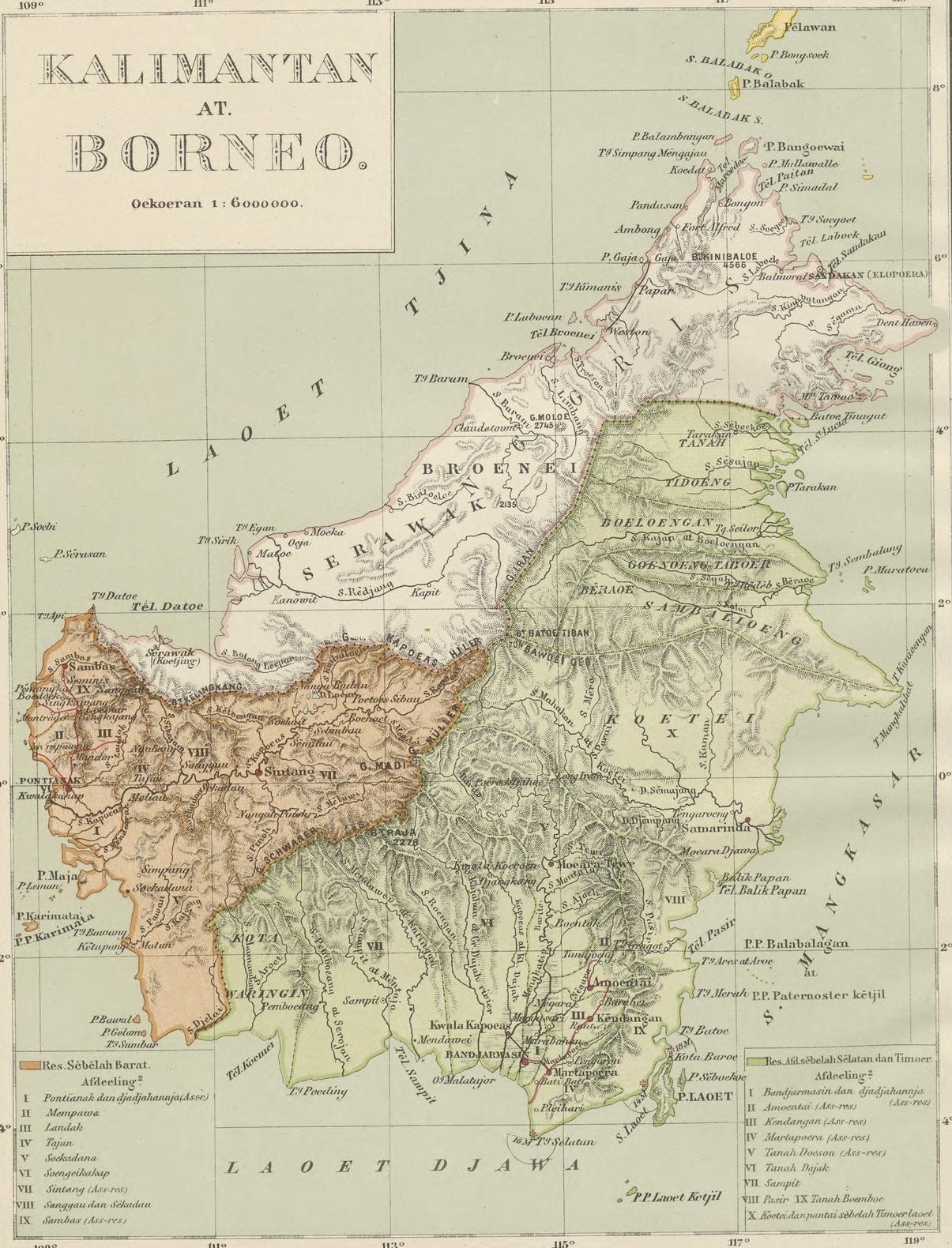
KALIMANTAN
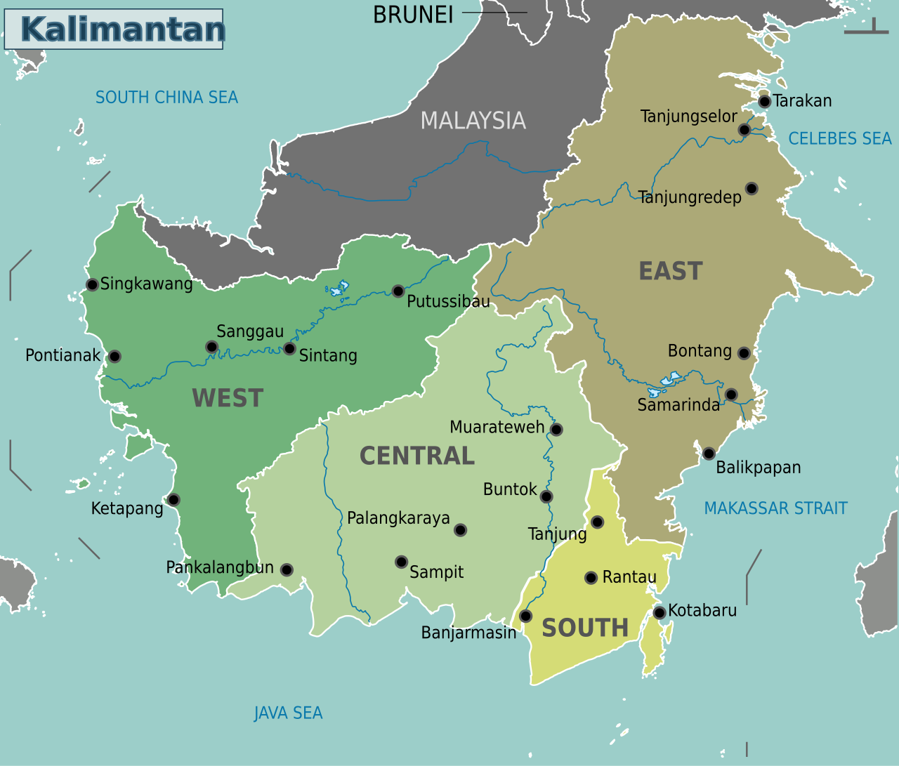
Kalimantan occupies the southern two thirds or so of Borneo and covers an area of 539,000 square kilometers (208,285 square miles). It is an Indonesian region. Malaysia’s Sabah and Sarawak, and the independent country of Brunei occupy the northern part of Borneo. Kalimantan is divided into five provinces: North Kalimantan, East Kalimantan, South Kalimantan, West Kalimantan and Central Kalimantan. In August 2019, the Indonesian government announced a plan to move Indonesia’s capital from Jakarta to a location near Balikpapan and Samarinda in East Kalimantan
Kalimantan is a vast, thinly settled region, covered mostly by large wildernesses with marshy coastal plains and jungle covered mountains in the interior. It is a land of rain forests where wild orangutans can still be found and former headhunters welcome tourists into their longhouses. It also suffers from heavy deforestation. Logging companies are quickly exploiting the timber resources and palm oil companies are burning down the forest create plantations. It is also ravaged by fires.At the end of drought in 1982, a fire raged in East Kalimantan for almost year, destroying 33,700 square kilometers (13,000 square miles) of forest. It was the largest fire ever recorded.
The name Kalimantan, which is sometimes spelled Klemantan, was derived from the Sanskrit word Kalamanthana, which means "burning weather island", or island with a very hot temperature, to describe its hot and humid tropical climate. It consists of the two words kal (time, season, period) and manthan (boiling, churning, burning). The word Kalamanthana is spelled Kalmantan, and then the indigenous people fixed it into Klemantan. It has been said that Kalimantan is a word that means "river of diamonds" in Malay. That is not true.
RELATED ARTICLES:
BORNEO: GEOGRAPHY, DEMOGRAPHY, STATES, TRAVEL factsanddetails.com
BORNEO BIODIVERSITY: RAINFORESTS, NEW, RARE SPECIES, THREATS factsanddetails.com
EARLY BORNEO HISTORY: FIRST PEOPLE, AUSTRONESIANS, TRADE factsanddetails.com
EARLY HUMANS IN BORNEO: NIAH CAVES 40,000-YEAR-OLD ROCK ART factsanddetails.com
LATER BORNEO HISTORY: COLONIALISM, BRITAIN, DUTCH, MALAYSIA, INDONESIA factsanddetails.com
HEADHUNTING IN BORNEO factsanddetails.com
TRIBAL PEOPLE OF BORNEO: LONGHOUSES, SAGO, ART factsanddetails.com
BORNEO ETHNIC GROUPS AND INDIGENOUS PEOPLES factsanddetails.com
DAYAKS: HISTORY, LANGUAGE, RELIGION factsanddetails.com
WEST KALIMANTAN (SOUTHWESTERN BORNEO) factsanddetails.com
GUNUNG PALUNG NATIONAL PARK factsanddetails.com
CENTRAL KALIMANTAN (SOUTHERN BORNEO) factsanddetails.com
TANJUNG PUTING NATIONAL PARK factsanddetails.com
EAST AND SOUTH KALIMANTAN (SOUTHEASTERN BORNEO) factsanddetails.com
NORTH KALIMANTAN (EASTERN BORNEO) factsanddetails.com
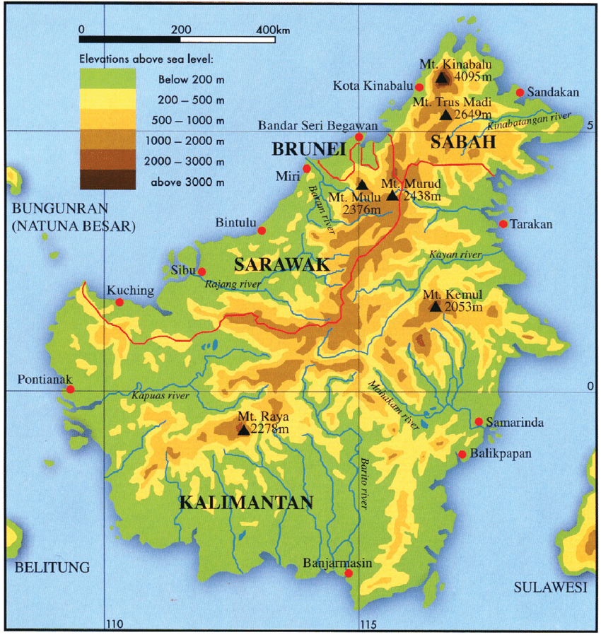
Borneo
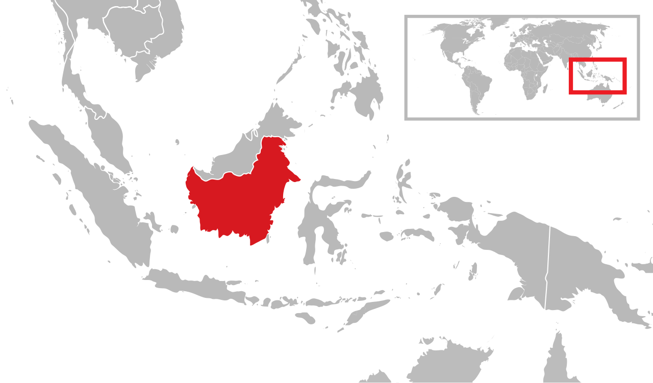
Kalimantan occupies the southern two thirds of Borneo. Borneo is the third largest island in the world after Greenland and New Guinea. Straddling the equator, it covers 748,168 square kilometers (288,869 square miles), more than twice the area of the British Isles or more than Texas and Louisiana combined, and measures about (1290 kilometers (800 miles) from north to south and 800 kilometers (500 miles) from east to west. Located at the geographic center of Maritime Southeast Asia, Borneo is part of an archipelago called the Greater Sunda Islands.
Borneo is thinly populated and covered by mountains, rain forests and increasingly palm oil plantations. Most of the cities and towns are along the coast. The soil is poor. Large areas of the coast are made up of marshes and mangrove swamps. Most of the interior consists of rugged mountains interspersed with deep gorges. This area is laced with clear and whiskey-colored streams.
Borneo contains extensive river systems and wetlands. The longest river is the Kapuas in West Kalimantan, which flows for about one thousand one hundred forty three kilometres. Other major rivers include the Mahakam in East Kalimantan, the Barito, Kahayan, and Mendawai in South Kalimantan, the Rajang in Sarawak, and the Kinabatangan in Sabah. Lake Sentarum, located in Kapuas Hulu Regency in West Kalimantan, forms part of an important inland wetland system that supports rich wildlife and seasonal flooding forests.
See Separate Article: BORNEO: GEOGRAPHY, DEMOGRAPHY, STATES, TRAVEL factsanddetails.com
Demography of Kalimantan
Kalimantan has a very small population. It accounts for 28 percent of Indonesia's area but only 5.5 of the population, and accounts about 16 million of the 23 million people that live in Borneo. Most live on the coast in the west. Most of the population is made of Malay Indonesians. Chinese have controlled trade in the region for centuries. Many residents are from or are descendants of people that came from elsewhere in Indonesia — most Javanese and Madurese — as part of Indonesia’s Transmigration effort to move people from overpopulated areas to thinly populated areas.
Kalimantan contains the largest share of Borneo’s population, with 17,259,155 inhabitants (2023), accounting for approximately seventy two percent of the total population. Kalimantan covers 539,238 square kilometers, or about seventy two and a half percent of the island’s land area, with an average population density of 30.8 inhabitants per square kilometers.
The population of Kalimantan grew from 12,541,554 in 2005 to 14,299,813 in 2010 to 15,320,017 in 2015 to 16,597,227 in 2020 to 17,259,155 in 2023. The population density (people per square kilometer) is 28.
Dutch in Kalimantan
The southern three-quarters of Borneo — now Kalimantan — was part of the Dutch East Indies. Dutch influence expanded through treaties with local sultans and gradual administrative control, in contrast to more rapid British deal-making and direct rule in northern Borneo. Early Dutch authority was limited and relied heavily on indirect governance through local rulers, while conflicts with Indigenous Dayak groups were frequent. By the early 20th century, the Dutch had shifted toward more direct colonial rule, which lasted until the Japanese occupation during World War II. Dutch influence formally ended with Indonesian independence in 1949. [Source: Wikipedia]
The Dutch presence in Borneo began in earnest when, alarmed by the British in northern Borneo in the early 1800s, the Dutch initiated policies of colonial expansion in the Outer Islands, which brought nearly all the land area of modern Indonesia under their control. Despite Dutch predominance in Java and islands crucial for the spice trade many areas of the archipelago—including Bali, Lombok, Aceh and Borneo—remained largely independent.
Under Dutch rule, the southern regions of Borneo were claimed following the Anglo-Dutch Treaty of 1824 — which followed Britain’s brief rule of Java and other Dutch territories. The treaty made Borneo the largest territorial component of the Dutch East Indies. Dutch control in Borneo initially focused on coastal trade and port settlements before extending inland along major river systems such as the Barito, Mahakam, and Kapuas. These rivers served as strategic corridors for military movement, economic extraction, and administration.
See Separate Article: BORNEO HISTORY: TRADE, BRITAIN, THE DUTCH, MALAYSIA, INDONESIA factsanddetails.com
Provinces of Kalimantan
Province name (name in Indonesia) — Area (square kilometers) — Provincial capital and largest city Population: 2005 census — 2010 census — estimated 2015 — 2020 census — estimated 2023 Population ensity/square kilometers —
West Kalimantan (Kalimantan Barat) — 147,307.00 — Pontianak — 4,042,817 — 4,393,239 — 4,783,209 — 5,396,821 — 5,623,328 — 32.5. West Kalimantan contains 23.8 percent of the population and 19.8 percent of the land area or Borneo.
Central Kalimantan (Kalimantan Tengah) — 153,564.50 — Palangkaraya — 1,913,026 — 2,202,599 — 2,490,178 — 2,669,969 — 2,773,747 — 16.2. Central Kalimanta contains 11.8 percent of the population and 20.6 percent of the land area of Borneo.
South Kalimantan (Kalimantan Selatan) — 38,744.23 — Banjarmasin 3,271,413 — 3,626,119 — 3,984,315 — 4,062,584 — 4,222,330 — 102.8. South Kalimantan contains 16.6 percent of the population and 5.2 percent of the land area of Borneo.
East Kalimantan (Kalimantan Timur) — 129,067 — Samarinda (capital) — Balikpapan (largest city) 2,840,874 — 3,550,586 — 3,422,676 — 3,766,039 — 3,909,740 — 26.5. East Kalimantan contains 16.8 percent of the population and 17.1 percent of the land area of Borneo.
North Kalimantan (Kalimantan Utara) — 71,176.72 — Tanjung Selor capital) — Tarakan (largest city) 473,424 — 524,526 — 639,639 — 701,814 — 730,010 — 8.5. North Kalimantan contains 3 percent of the population and 9.7 percent of the land area of Borneo. [Source: Wikipedia]
Ethnic Groups in Kalimantan
Ethnicity — West Kalimantan — Central Kalimantan — South Kalimantan — North and East Kalimantan — Total
Banjarese — 14,430 (0.33 percent) — 464,260 (21.28 percent) — 2,686,627 (74.84 percent) — 440,453 (12.45 percent) — 3,605,770 (26.31 percent)
Dayak — 1,531,989 (34.93 percent) — 1,029,182 (46.62 percent) — 80,708 (2.23 percent) — 351,437 (9.94 percent) — 2,993,316 (21.78 percent)
Javanese — 427,238 (9.74 percent) — 478,393 (21.67 percent) — 523,276 (14.51 percent) — 1,069,605 (30.24 percent) — 2,498,512 (18.18 percent)
Malay — 1,484,085 (33.84 percent) — 87,348 (3.96 percent) — 3,681 (0.10 percent) — 6,053 (0.17 percent) — 1,581,167 (11.51 percent)
Buginese — 137,282 (3.13 percent) — 17,104 (0.77 percent) — 101,727 (2.81 percent) — 735,819 (20.81 percent) — 991,932 (7.22 percent)
Madurese — 274,869 (6.27 percent) — 42,668 (1.93 percent) — 53,002 (1.47 percent) — 46,823 (1.32 percent) — 417,362 (3.04 percent)
Chinese — 358,451 (8.17 percent) — 5,130 (0.23 percent) — 13,000 (0.36 percent) — 32,757 (0.93 percent) — 409,338 (2.98 percent)
Kutai — None — None — None — 275,696 (7.80 percent) — 275,696 (2.01 percent)
Sundanese — 49,530 (1.13 percent) — 28,580 (1.29 percent) — 24,592 (0.68 percent) — 55,659 (1.57 percent) — 158,361 (1.15 percent)
Batak — 26,486 (0.60 percent) — 12,324 (0.56 percent) — 12,408 (0.34 percent) — 37,145 (1.05 percent) — 88,363 (0.64 percent)
Others — 80,996 (1.85 percent) — 42,378 (1.92 percent) — 114,971 (3.18 percent) — 485,056 (13.72 percent) — 723,401 (5.26 percent)
Total — 4,385,356 (100 percent) — 2,207,367 (100 percent) — 3,613,992 (100 percent) — 3,536,503 (100 percent) — 13,743,218 (100 percent)
Religions in Kalimantan
Religion in Kalimantan (2023): 1) Islam — 13,566,483 (78.4 percent); 2) Protestantism — 1,608,857 (9.30 percent); 3) Roman Catholic — 1,573,067 (9.09 percent); 4) Buddhism Buddhism — 335,722 (1.94 percent); 5) Hinduism Hinduism — 187,035 (1.08 percent); 6) Confucianism — 17,376(0.10 percent); 7) Aliran Kepercayaan — 11,151; 8) Folk religion and others (0.06 percent); 9) Overall — 17,299,691
Religion by Province according to the 2010 census:
Religion — West Kalimantan — Central Kalimantan — South Kalimantan — North Kalimantan — East Kalimantan — Total
Islam — 2,603,318 (59.22 percent) — 1,643,715 (74.31 percent) — 3,505,846 (96.67 percent) — 378,478 (72.14 percent) — 2,655,227 (87.68 percent) — 10,786,584 (78.23 percent)
Protestantism — 500,254 (11.38 percent) — 353,353 (15.97 percent) — 47,974 (1.32 percent) — 109,358 (20.84 percent) — 228,022 (7.53 percent) — 1,238,961 (8.99 percent)
Roman Catholic — 1,008,368 (22.94 percent) — 58,279 (2.63 percent) — 16,045 (0.44 percent) — 29,366 (5.60 percent) — 109,263 (3.61 percent) — 1,221,321 (8.86 percent)
Hinduism — 2,708 (0.06 percent) — 11,149 (0.50 percent) — 16,064 (0.44 percent) — 288 (0.05 percent) — 7,369 (0.24 percent) — 37,578 (0.27 percent)
Buddhism — 237,741 (5.41 percent) — 2,301 (0.10 percent) — 11,675 (0.32 percent) — 3,879 (0.74 percent) — 12,477 (0.41 percent) — 268,073 (1.94 percent)
Confucianism — 29,737 (0.68 percent) — 414 (0.02 percent) — 236 (0.01 percent) — 175 (0.03 percent) — 905 (0.03 percent) — 31,467 (0.23 percent)
Other religions — 2,907 (0.07 percent) — 138,419 (6.26 percent) — 16,465 (0.45 percent) — 25 (0.00 percent) — 824 (0.03 percent) — 158,640 (1.35 percent)
Not Stated — 671 (0.01 percent) — 220 (0.01 percent) — 3 (0.00 percent) — 454 (0.09 percent) — 1,497 (0.05 percent) — 2,845 (0.02 percent)
Not Asked — 10,279 (0.23 percent) — 4,239 (0.19 percent) — 12,308 (0.34 percent) — 2,633 (0.50 percent) — 12,903 (0.43 percent) — 42,362 (0.31 percent)
Total — 4,395,983 (100 percent) — 2,212,089 (100 percent) — 3,626,616 (100 percent) — 524,656 (100 percent) — 3,028,487 (100 percent) — 13,787,831 (100 percent)
Nusantara — the New Capital of Indonesia in Kalimantan
In 2019, the Indonesia government announced plans to move the capital of Indonesia from Jakarta to Nusantara in Kalimantan as a solution to Jakarta’s congestion, pollution, and sinking land. Nusantara is officially known as Nusantara Capital City. It under construction and is located on the east coast of Borneo, within the East Kalimantan regencies of Kutai Kartanegara and Penajam North Paser. Planned as a special national capital region with provincial-level status, Nusantara is close to the port city of Balikpapan, which serves as the main gateway to the new capital.
Construction began in 2022 after earlier postponements caused by the COVID-19 pandemic, initially focusing on land clearing and the development of access roads. The project is estimated to cost around US$35 billion and is scheduled to be developed in five phases through 2045, coinciding with the centenary of Indonesia’s independence. The first phase, known as the Main Governmental Area, started in August 2022. An estimated 150,000 to 200,000 workers from across the country have been involved in the project, along with additional labor from nearby regions to encourage local participation.
The project has faced criticism over weak public consultation, land disputes with indigenous communities, foreign investment concerns, and its undemocratic design. Observers warn that Nusantara, located far from Jakarta and governed by presidential appointees rather than elected leaders, risks distancing the government from civil society and protest, weakening democratic accountability. Critics see the project as an avoidance of Jakarta’s unresolved urban crises rather than a solution, and draw parallels with new capitals in Myanmar and Egypt that insulated rulers from public dissent. [Source: Koh Ewe, Time, October 30, 2023]
Image Sources: Wikimedia Commons
Text Sources: Indonesia Tourism website (indonesia.travel), Indonesia government websites, UNESCO, Wikipedia, Lonely Planet guides, New York Times, Washington Post, Los Angeles Times, National Geographic, The New Yorker, Bloomberg, Reuters, Associated Press, AFP, Japan News, Yomiuri Shimbun, Compton's Encyclopedia and various books and other publications.
Last updated in January 2026