BORNEO
Borneo is the third largest island in the world after Greenland and New Guinea. Straddling the equator, it covers 748,168 square kilometers (288,869 square miles), more than twice the area of the British Isles or more than Texas and Louisiana combined, and measures about (1290 kilometers (800 miles) from north to south and 800 kilometers (500 miles) from east to west. Located at the geographic center of Maritime Southeast Asia, Borneo is part of an archipelago called the Greater Sunda Islands.
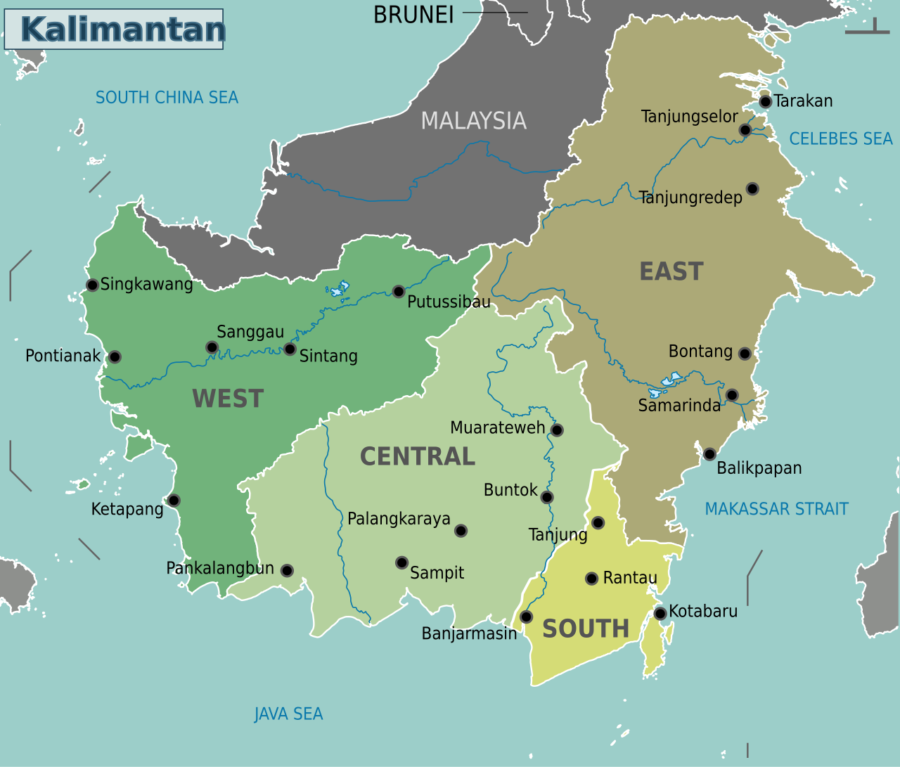
Borneo is politically divided into three states, with the borders broadly following previous demarcation set up by the British and Dutch, the former colonial rulers of Borneo. The northern 25 percent of Borneo is occupied the Malaysian states of Sabah and Sarawak, and the Islamic sultanate of Brunei; and the southern 75 percent is occupied by the Indonesian state of Kalimantan. Brunei is on the north coast of Borneo between Sarawak and Sabah.
Borneo doesn’t have as pronounced rainy and wet season as other places in Southeast Asia have. Rain falls steadily throughout the year. rainfall amounts are often high. The people of Borneo traditionally raised dry rice, sago, tapioca, ad sweet potatoes and hunted, fished and gathered wild plants from the forest. Because the terrain is so rough and waterlogged there are few good roads. Rivers have traditionally provided the main transportation routes.
Geology of Borneo began to form during the Mesozoic era (252 to 66 million years ago). For much of its geological history, the island was part of Sundaland, a landmass connected to mainland Southeast Asia. This connection lasted until rising sea levels at the end of the last ice age isolated Borneo from the continent. Today, Borneo contains seven distinct ecoregions, including vast areas of some of the oldest tropical rainforests in the world.
Books: “Into the Heart of Borneo” By Redmond O’Hanlon; “The Wasting of Borneo: Dispatches From a Vanishing World” by Alex's Shoumatoff (Beacon Press, April 2017)
RELATED ARTICLES:
BORNEO BIODIVERSITY: RAINFORESTS, NEW, RARE SPECIES, THREATS factsanddetails.com
TRIBAL PEOPLE OF BORNEO: LONGHOUSES, SAGO, ART factsanddetails.com
BORNEO ETHNIC GROUPS AND INDIGENOUS PEOPLES factsanddetails.com
DAYAKS: HISTORY, LANGUAGE, RELIGION factsanddetails.com
EARLY BORNEO HISTORY: FIRST PEOPLE, AUSTRONESIANS, TRADE factsanddetails.com
EARLY HUMANS IN BORNEO: NIAH CAVES 40,000-YEAR-OLD ROCK ART factsanddetails.com
LATER BORNEO HISTORY: COLONIALISM, BRITAIN, DUTCH, MALAYSIA, INDONESIA factsanddetails.com
JAMES BROOKE AND MAKING NORTHERN BORNEO PART OF THE BRITISH EMPIRE factsanddetails.com
FIGHTING WITH BORNEO PIRATES factsanddetails.com
HEADHUNTING IN BORNEO factsanddetails.com
VIOLENCE AGAINST THE MADURESE IN BORNEO factsanddetails.com
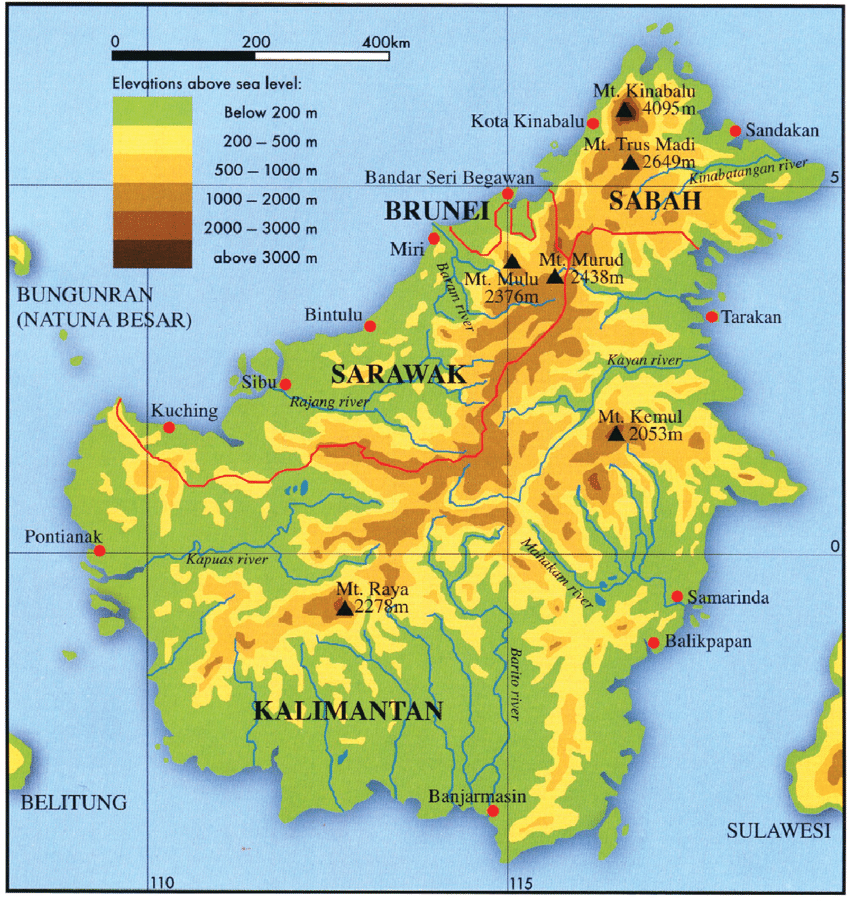
Geography of Borneo
Borneo is thinly populated and covered by mountains, rain forests and increasingly palm oil plantations. Most of the cities and towns are along the coast. The soil is poor. Large areas of the coast are made up of marshes and mangrove swamps. Most of the interior consists of rugged mountains interspersed with deep gorges. This area is laced with clear and whiskey-colored streams. The highest point is 4,095-meter (13,455-foot) -high Mount Kinabulu not so far from the coast in Sabah. In Kalimantan few areas rise above 1,000 meters (3,300 feet). The highest point in Borneo’s central range is 2,920 (9,582 meters).
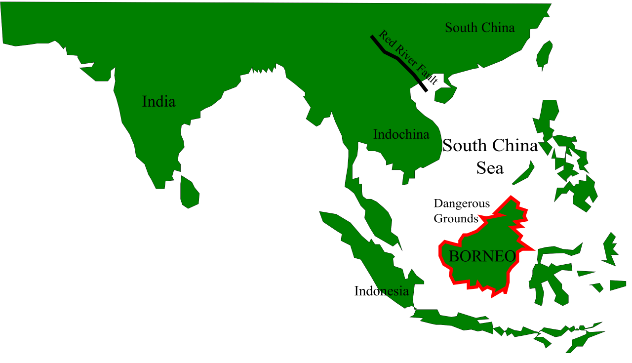
When Borneo was part of Sunderland during the ice ages it was connected with Java and Sumatra and made up the upland regions of a broad peninsula extending eastward from what is now Southeast Asia. The South China Sea and the Gulf of Thailand now cover the low-lying portions of this former peninsula. Deep waters between Borneo and Sulawesi prevented the formation of a land bridge, creating a biological boundary known as Wallace’s Line, which separates Asian species from those of the Australia and New Guinea region. [Source: Wikipedia]
Borneo is the largest island in Asia. It is bordered by the South China Sea to the north and northwest, the Sulu Sea to the northeast, and the Celebes Sea and Makassar Strait to the east. To the south are the Java Sea and the Karimata Strait. West of Borneo are the Malay Peninsula and Sumatra, while Java lies to the south and Sulawesi to the east. The Philippine Islands are located to the northeast.
Borneo contains extensive river systems and wetlands. The longest river is the Kapuas in West Kalimantan, which flows for about one thousand one hundred forty three kilometres. Other major rivers include the Mahakam in East Kalimantan, the Barito, Kahayan, and Mendawai in South Kalimantan, the Rajang in Sarawak, and the Kinabatangan in Sabah. Lake Sentarum, located in Kapuas Hulu Regency in West Kalimantan, forms part of an important inland wetland system that supports rich wildlife and seasonal flooding forests.
The island is also notable for its remarkable cave systems. In Sarawak, Clearwater Cave contains one of the longest underground rivers in the world, while Deer Cave is home to more than three million bats, whose accumulated guano reaches depths of over one hundred metres. In Sabah, the Gomantong Caves are famous for the presence of millions of cockroaches. Gunung Mulu National Park in Sarawak and the Sangkulirang Mangkalihat karst region in East Kalimantan are especially rich in limestone landscapes, containing thousands of caves of varying sizes. These geological features contribute significantly to Borneo’s ecological complexity and scientific importance.
Origin of the Name Borneo
It is said word Borneo originated from a remark made by Pigafetta, who traveled with Magellan on his journey around the world in1521 He gave the name ‘Burne’ to the entire island because it was extremely island as it took the sailors three months to circumnavigate it. This story is a myth for several reasons.
The name Borneo is derived Brunei, the present-day country which was kingdom in the 16th century kingdom when Europeans first came in contact with it. The name Brunei possibly derives from the Sanskrit word váru, ), meaning either "water" or Varuna, the Hindu god of rain. Indonesian natives called it Kalimantan, which was derived from the Sanskrit word Kalamanthana, meaning "burning weather island" (to describe its hot and humid tropical weather).
In earlier times, the island was known by other names. In 977, Chinese records began to use the term Bo-ni to refer to Borneo. In 1225, it was also mentioned by the Chinese official Chau Ju-Kua. The Javanese manuscript Nagarakretagama, written by Majapahit court poet Mpu Prapanca in 1365, mentioned the island as Nusa Tanjungnagara, which means the island of the Tanjungpura Kingdom.
Borneo Ecology and Resources
Rainforests of Borneo have been estimated to be approximately 140 million years old, making them among the oldest rainforests on Earth. The dominant group of trees in the lowland rainforests, known as dipterocarps, has prevailed for millions of years and continues to shape the structure of these forests today. Borneo is a major centre for the evolution and distribution of endemic plant and animal species, many of which are found nowhere else in the world. The rainforest also provides one of the last remaining natural habitats for the endangered Bornean orangutan, along with other rare forest species such as the Borneo elephant, the eastern Sumatran rhinoceros, the Bornean clouded leopard, the Bornean rock frog, Hose’s palm civet, and the Dayak fruit bat.
As Borneo was once connected to the Southeast Asian mainland and the plant and animal life in both places are similar. There are orangutans, gibbons, monkeys, honey bears, giant butterflies, and black hornbills (sacred to the Dayaks), clouded leopards, wild pigs and,a few elephants and rhinos. They are no tigers. Freshwater dolphins live in Mahakam River in east Kalimantan. Crab-eating monkeys and crocodiles live in the marshes. Typically in Borneo you find 100 or different tree species in one hectare and 200 or 300 plant species in an area the size of a living room. Even though there over 3,000 tree species on Borneo dipterocarps make up half of all the giant canopy trees. Hundreds of orchid species are found in Borneo.
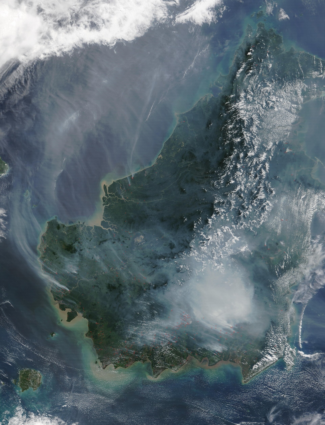
The rain forest on Borneo covers an area about the size of France but is shrinking all the time as logging, palm oil and mining interests penetrate deep into its interior. Valuable ironwood, teak, ebony, sandalwood and plywood-producing rain forest trees have largely been harvested. Crops grown on Borneo include rubber, palm oil, rattan, hemp, sago, pepper, sugar cane and rice. Oil and natural gas, much of it offshore, has been found in the east and north. There are also large coal reserves. Gold is panned from the rivers and iron ore, antimony, lead, zinc, arsenic, copper, mercury, chromite and silver are all found here but are generally too expensive to mine profitably.
See Separate Articles: BORNEO BIODIVERSITY: NEW AND RARE SPECIES, THREATS ioa.factsanddetails.com ANIMALS OF BORNEO: ELEPHANTS, CLOUDED LEOPARDS, FLYING LEMURS AND SNAKES ioa.factsanddetails.com
Demography of Borneo
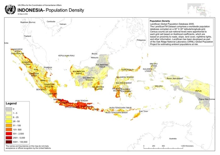
Borneo had a total population of 23,053,723 inhabitants according to the 2020 censuses. The island had an average population density of 30.8 inhabitants per square kilometers. Most of the population is concentrated in coastal cities, while the interior regions are more sparsely populated, with small towns and villages generally located along river systems that serve as key transportation and livelihood corridors. [Source: Wikipedia]
Roughly 72 percent of the population and land area of Borneo is Indonesia and 28 percent in Malaysia and Brunei. The Indigenous inhabitants are Dayaks, a tribe that only recently gave up head hunting and were once referred to as the "wild men of Borneo." The coastal areas are dominated by Muslim Malays. Some of them are Dayaks who began converting to Islam after the 15th century. Other groups such as the Javanese, Sudanese, Madurese, Chinese and Bugis from Sulawesi arrived mostly in the 20th century, particularly in the last three decades as part of Indonesia's transmigration program. The Dayaks are now greatly outnumbered by Malays and Indonesians from Java and elswehre
The hundreds of different Indigenous groups, cultures and languages in Borneo are loosely grouped under the term "Dayak". "Dayak" is sometimes used as a collective label for non Muslim Austronesian Indigenous peoples of Borneo. This grouping includes the Iban and Bidayuh peoples of East Malaysia, as well as the Kayan, Kenyah, and Ngaju peoples of Kalimantan. Historically, many Dayak communities lived in large communal longhouses, had no rigid class hierarchy, and relied on shifting cultivation as their primary means of subsistence.
Populations and Sizes of the Different Parts of Borneo
Politically, Borneo is divided among three countries: Brunei, Indonesia, and Malaysia. Brunei has a population of 460,345 people, representing about two percent of the island’s population. It covers an area of 5,765 square kilometers, which is less than one percent of Borneo’s total land area, and has a population density of just over seventy two inhabitants per square kilometers. The capital city is Bandar Seri Begawan.
The Indonesian portion of Borneo — Kalimantan — contains the largest share of Borneo’s population, with 16,544,696 inhabitants, accounting for approximately seventy two percent of the total population. Kalimantan covers 539,238 square kilometers, or about seventy two and a half percent of the island’s land area, with an average population density of 30.8 inhabitants per square kilometers.
North Kalimantan has a population of 713,622 people spread across 72,275 square kilometers, resulting in a low population density of 9.7 inhabitants per square kilometers, with Tanjung Selor as its capital. North Kalimantan contains 3 percent of the population and 9.7 percent of the land area of Borneo.

East Kalimantan has 3,849,842 inhabitants over an area of 127,347 square kilometers, with Samarinda as its capital. East Kalimantan contains 16.8 percent of the population and 17.1 percent of the land area of Borneo.
South Kalimantan is more densely populated, with 3,808,235 people living in 38,744 square kilometers, giving it a density of over one hundred inhabitants per square kilometers, and Banjarbaru as its capital. South Kalimantan contains 16.6 percent of the population and 5.2 percent of the land area of Borneo.
Central Kalimantan has a population of 2,702,200 people over 153,565 square kilometers, with Palangka Raya as its capital. Central Kalimanta contains 11.8 percent of the population and 20.6 percent of the land area of Borneo.
West Kalimantan is home to 5,470,797 people, covers 147,307 square kilometers, and has Pontianak as its capital. West Kalimantan contains 23.8 percent of the population and 19.8 percent of the land area or Borneo.
The Malaysian portion of Borneo, commonly referred to as East Malaysia, has a combined population of 5,967,582 inhabitants, representing about twenty six percent of the island’s population. It covers 198,447 square kilometers, or roughly twenty six and a half percent of the land area, with an average population density of about thirty one inhabitants per square kilometers.
Sabah has 3,418,785 inhabitants living in 73,904 square kilometers, with Kota Kinabalu as its capital. Sabah contains 14.9 percent of the population and 9.9 percent of the land area of Borneo.
Sarawak has a population of 2,453,677 people and covers 124,450 square kilometers, with Kuching as its capital. Sarawak contains 10.7 percent of the population and 16.7 percent of the land area of Borneo.
The federal territory of Labuan has a much smaller population of 95,120 people but a very high population density due to its area of only ninety two square kilometers, with Victoria as its capital. All parts of East Malaysia follow the time standard of Coordinated Universal Time plus eight hours.
Travel in Borneo
Most travel is done by river boat. Finding wildernesses with virgin rain forest is getting harder to find and requires penetration further and further up the rivers and deeper into the forest. To reach the wilderness areas can be expensive and time consuming. The Malaysian provinces of Sabah and Sarawak occupy northern Borneo and Indonesia’s provinces of East and Kalimantan occupy southern Borneo.
The large rivers are the Kapuas, Brtio and Rajand, which serve as major transportation routes to the interior. There are few railways or paved roads. To get to Kalimantan from other parts of Indonesia you more or less have to fly. There is no other real alternative. The best time to travel is the rainy season when they rivers are deep enough to navigate and leaches are a problem. Dangers in Borneo include turbulent rives with whirlpools and poisonous centipedes.
Guides are necessary for negotiating the hiking trails which are crossed by hip-deep mud and difficult-to-cross rivers. Maps of this area were left blank until recently and still have exclaimers like "Your Guess is as good as mine" and "relief data irreconcilable." About the only inhabitants of the interior are Dayak Indians, a tribe of former head hunters.
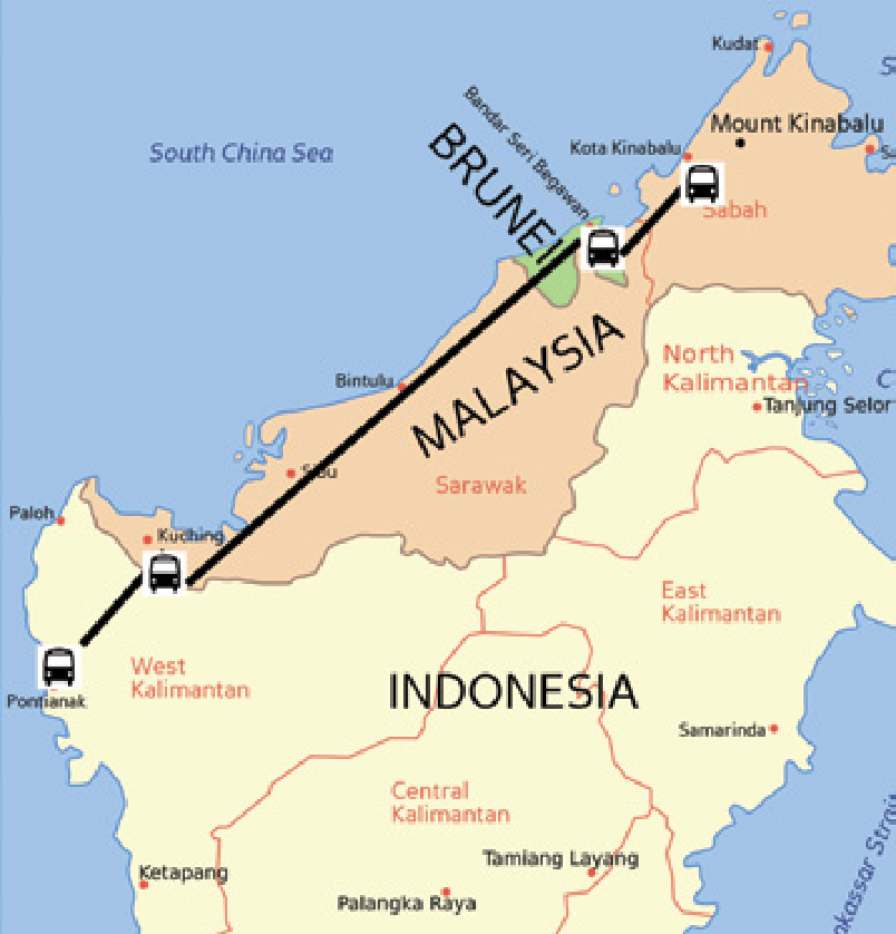
Bus Between Kalimantan (Indonesia), Sarawak and Brunei
Indonesian state-run bus firm Damri has served the Pontianak-Kuching-Brunei route since 2008. The Damri Transport Company was appointed by the Indonesian government to operate on the route. The Brunei government appointed JPS company to serve the reverse route Brunei-Kuching-Pontianak. Eight buses each from the two countries have been prepared to serve the route. One-way trip from Brunei to Kuching to Pontianak is 1,200-kilometer long and takes 35 hours. [Source: etawau.com]
There are plenty of bus companies between Pontianak and Kuching. The cost of a return economy class ticket is about IDR380,000 (USD38, 40-50 seats per bus), IDR 200,000 for one-way (At some places it is also possible to pay in MYR since most of the companies are malaysian). While a more comfortable Super Executive class is IDR300,000 (USD32) for return trip (larger size 20-25 seats per bus). As of September 12th, buses will depart and arrive at Sungai Ambawang bus terminal. Most of the bus companies' offices are at Jl. Sisingamangaraja No.155-159 and this is maybe the major point. (The office of one of the major Malaysian companies - SJS, is there. Tel. (0561) 734626,739544,765651.) Also you may check for info at BusAsia (Tebakang Express; other major Malaysian company) web page.
There are buses in the morning and in the evening. In evenings the journey from Pontianak usually starts around 9.00 PM WIB (Waktu Indonesia Barat - Western Indonesian Time) with all buses traveling in convoy, the journey is comfortable as drivers are driving moderately. Reaching the border check-points between 4.00 - 6.00 AM WIB (with one or two rest stops in between) just as the checkpoints open their gate. The journey from checkpoints to Kuching is another 2 hours at moderate driving, reaching Kuching regional bus terminal at 7.00 - 9.00 AM Malaysian Standard Time (1 hour ahead of Western Indonesian Time). Buses from Kuching regional bus terminal to Pontianak leave on two schedules, Economy class leaves at 7.00 AM and 1 PM Malaysian Standard Time, while Super Executive class leaves at 11.00 AM Malaysian Standard Time. [Source: Wikitravel]
Daily bus services between Kuching and Pontianak. Journey is 8-10 hours. Immigration point in Teledu. No bus services from Pontianak to Banjarmasin. Kuching To Pontianak, Indonesia. RM 45.00, 8 hours. Buses depart from Kuching's Penrissen Road Terminal. Biaramas/Tebakang Express (Tel: 456999) at 7.30 am.. SJS (Tel: 456999) at 8 am and 1.00 pm. The up market SJS 'Super Executive' departs 11.00 am and costs RM 70. This bus has more leg room and meals are included. Kirata Express departs 7.30 am Sapphire Pacific at 11 am Sri Merah Express at 7 am and 10 am - book through Vital Focus Transportation (Tel: 453190 or 461277) or Borneo Interland (63 Main Bazaar, Tel: 413595). ATS (Tel: 457773) departs 7.30 am, Eva Express (Tel: 576761) at 7 am (economy) and 11 am (super class, RM 70) and Damri (Tel: 572098) at 8 am, 11.30 am and 1 pm. [Source: etawau.com]
Image Sources: Wikimedia Commons
Text Sources: Indonesia Tourism websites, Indonesia government websites, Malaysia Tourism websites, Malaysia government websites,UNESCO, “Encyclopedia of World Cultures Volume 5: East/Southeast Asia:” edited by Paul Hockings, 1993; National Geographic; New York Times, Washington Post, Los Angeles Times, Lonely Planet Guides, Library of Congress, Smithsonian magazine, The New Yorker, Time, Reuters, AP, AFP, Wikipedia, BBC, CNN, and various books and other publications.
Last Updated January 2026