SOUTH KALIMANTAN
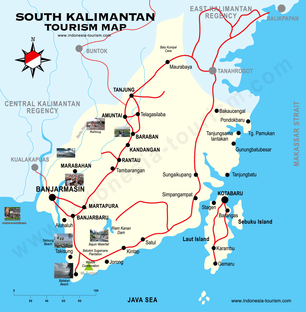
South Kalimantan is known as the province of a "Thousand Rivers." One of longest is the Barito River, which one travel brochure said was almost 4000 kilometers long (it is actually about 900 kilometers long). Another major river is the Martapura. Both of these rivers have many tributaries and travel among the main rivers and tributaries is often done by "klotok boat" or river bus.
Along the rivers people build traditional floating houses made of bamboo and wood called "lantings." Many of the markets are floating markets. This makes sense when you think about it because the people here transport things by river, with a floating market they don't have to unload their stuff from their boats. These markets are held from 5:00am to 9:00am in the morning.
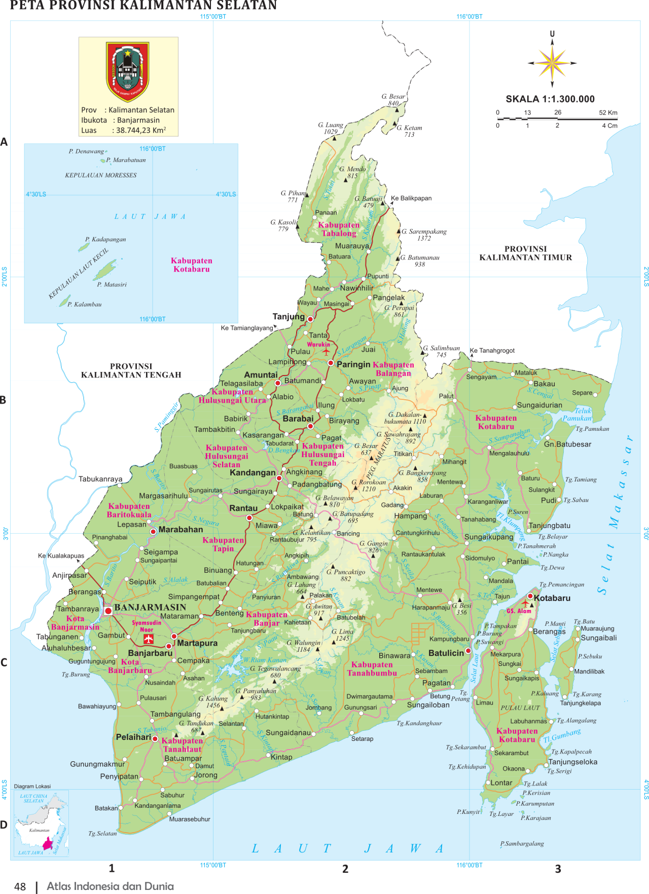
South Kalimantan (Kalimantan Selatan) is Kalimantan’s smallest province. It covers 38,744.23 square kilometers. Its population grew from 3,271,413 in 2005 to 3,626,119 in 2010 to 3,984,315 in 2015. The population density (people per square kilometer) is 102.8. The provincial capital and largest city is Banjarmasin. Important industries include logging, diamond mining and rattan processing.
The Meratus Mountains divide south Kalimantan into two distinct regions. The southern section of the province is much flatter with large rivers meandering through lowlands to vast mangrove swamps along the coast. South Kalimantan has exceptionally fertile land. Many villages and settlements are built along the Barito River, by the indigenous Banjar people. Exquisite traditional and commercial handicrafts are all made from local raw materials which include a variety of precious and semi precious stones, gold, silver, brass, iron and wide variety of woods including bamboo and rattan. Soto Banjar is a food specialty in South Kalimantan. It is best served hot and eaten with steamed rice. It is actually chicken soup, Banjar style. Several spices like clove, nutmeg and cinnamon are added. The variety of kue or cakes available here are plenty and very tasty. Deep fried breads with yummy fillings, sticky banana rice cakes, are a must for those with sweet teeth.
South Kalimantan is well connected with cities all over the Indonesian Archipelago through Syamsudin Noor Airport, which is about 25 kilometers from Banjarmasin. Soto Banjar is a food specialty in South Kalimantan. It is best served hot and eaten with steamed rice. It is actually chicken soup, Banjar style. Several spices like clove, nutmeg and cinnamon are added. The variety of kue or cakes available here are plenty and very tasty. Deep fried breads with yummy fillings, sticky banana rice cakes, are a must for those with sweet teeth. Tourism Office: Jl. Pramuka No. 14, Banjarmasin, Tel. (62-511) 3264511, fax: (62-11) 3264512
RELATED ARTICLES:
NORTH KALIMANTAN (EASTERN BORNEO) factsanddetails.com
KALIMANTAN (INDONESIAN BORNEO): GEOGRAPHY, DEMOGRAPHY, GROUPS factsanddetails.com
BORNEO: GEOGRAPHY, DEMOGRAPHY, STATES, TRAVEL factsanddetails.com
BORNEO BIODIVERSITY: RAINFORESTS, NEW, RARE SPECIES, THREATS factsanddetails.com
EARLY BORNEO HISTORY: FIRST PEOPLE, AUSTRONESIANS, TRADE factsanddetails.com
EARLY HUMANS IN BORNEO: NIAH CAVES 40,000-YEAR-OLD ROCK ART factsanddetails.com
LATER BORNEO HISTORY: COLONIALISM, BRITAIN, DUTCH, MALAYSIA, INDONESIA factsanddetails.com
HEADHUNTING IN BORNEO factsanddetails.com
TRIBAL PEOPLE OF BORNEO: LONGHOUSES, SAGO, ART factsanddetails.com
BORNEO ETHNIC GROUPS AND INDIGENOUS PEOPLES factsanddetails.com
DAYAKS: HISTORY, LANGUAGE, RELIGION factsanddetails.com
WEST KALIMANTAN (SOUTHWESTERN BORNEO) factsanddetails.com
CENTRAL KALIMANTAN (SOUTHERN BORNEO) factsanddetails.com
Banjarmasin
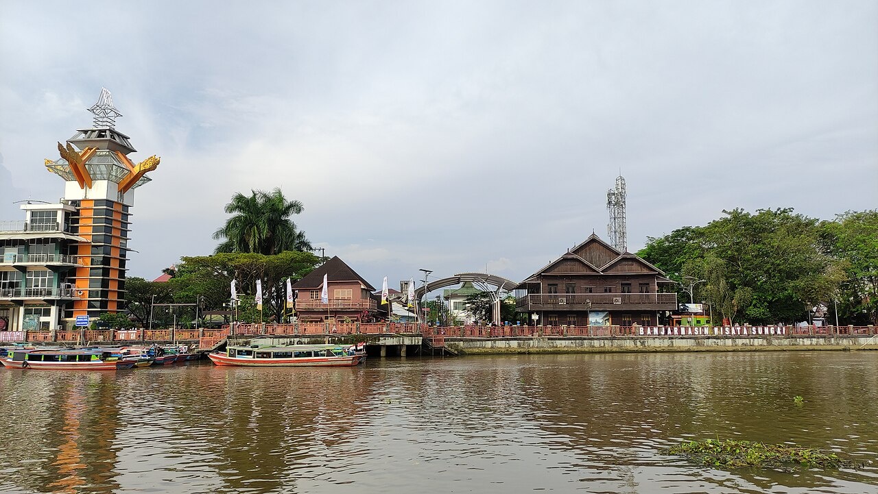
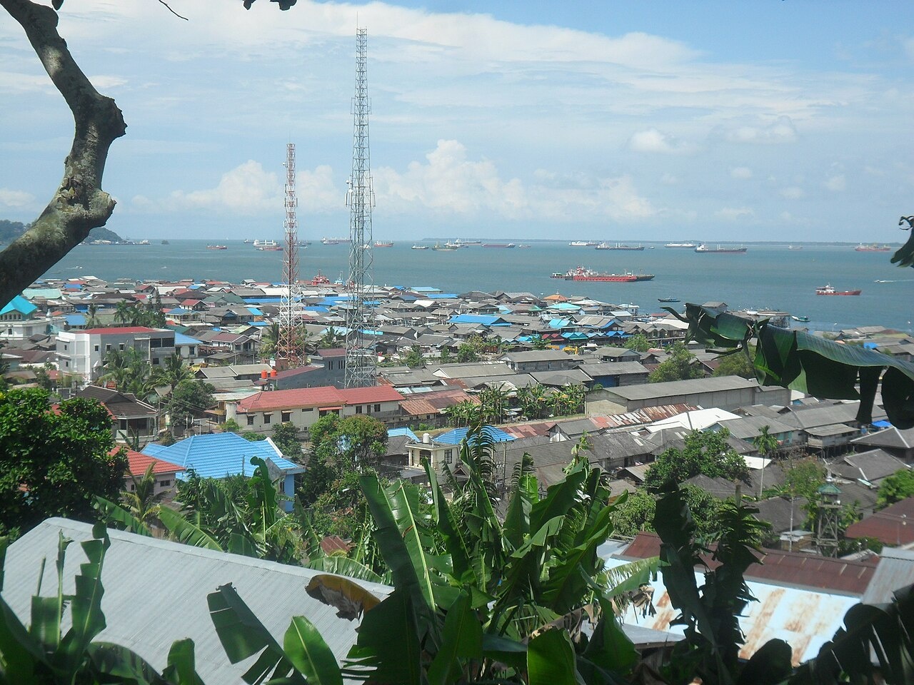
Banjarmasin is the capital city of South Kalimantan. Situated on the delta of the Barito River, 23 kilometers from the Java Sea, it is known as "City of Rivers" and much of everyday life still takes place on the water. Many people live in stilted houses perched over rivers they wash, brush their teeth and go to the bathroom in as well as drink. Goods are moved by boat on the city’s web of canals. Around the city factories take in rain forest trees and spit out plywood. Many people chew betel nut.
Banjarmasin is arguably Kalimantan’s nicest city. It is home to around 800,000 people. Among the city’s attractions are floating markets on the Barito River in which hundred of canoes and boats come together to sell all kinds of goods; a lovely golden-domed mosque; a large shopping mall; and the grave of Borneo's first Muslim sultan. If you go to floating market get there early, preferably round 6:30am. Most of the good stuff sells out by 9;30am. Particularly interesting are the boats that sell traditional medicines.
People get around in bajaj (motorcycle taxis) becaks (three-wheel pedicabs) and water taxis and buses called klotoks. Many people recommend hiring a motorized canoe for a few hours for cruise around the city. Connections to the Martapura River and trips up the Barito can be made from here. If you want to visit some primary tropical rain forest a three- to five-day river trip is necessary. These trips include jungle trekking, sleepovers in Dayak villages, swimming in waterfall pools and rafting in a bamboo rafts. Leeches are often a problem. Most of the forests nearby on the rivers have been cleared away.
Near Banjarmasin
Pulau Kembang (20 minute klotok ride from Banjarmasin) is 60 hectare island inhabited by tame monkeys. The species found here are found only in Borneo including the "bekantan." Most of the visitors that come here are Chinese who believe it is good luck to feed a monkeys some peanuts. The monkeys—long-tailed macaques— are spoiled and aggressive. They occasionally rip clothes, scratch arms and make off with cameras. Pulau Kembang mean Flower Island.
Kuala Kapuas (40 kilometers from Banjarmasin) is located aon the Kapuas River, A well-known tourist attraction is Telo Island, a pleasant fishing village and port. For the adventurer, white-water rafter and nature lovers, there is Gohong Rawai, known for its beautiful and challenging rapids. The gold mines of Teweh and Batu Api, Rungan district, are interesting. In this region, gold mining is a major source of livelihood for the people, who pan for the valuable metal using old traditional methods.
Cempaka Diamond Digging Mines (26 miles from Banjarmasin) is where local miners up to their chest in muck and mud work with very simple tools to find diamond. Male male miners dig up mud looking for diamonds while women pan through for it gold. In 1985 a 116.7 carat diamond was found here in a hole 45 feet deep. In 1965, a 167-carat diamond was found. Most don’t find very much except agates, amethysts and gold dust.
Martapura (40 kilometers from Banjarmasin) is where the diamonds are polished. Unless you know hat you are doing, don't buy diamond from freelance dealers. Many of them sell glass. Matapua is the home of the Mangkarat Museum. Built in the shape of a traditional Banjar house, it contains Stone Age artifacts, royal costumes, bronze pieces excavated from ancient Hindu temples, musical instrument, Dayak woodcarvings, models of ships and other good stuff.
Pulau Kaget (1½ hour by klotok further up the Barito River from Banjarmasin) is another monkey island, but wilder. Most of monkeys here are shy long-nosed proboscis monkeys who spend most of their time in the swamp and come into feed on th mangrove trees at dawn and dusk. They are shy and most visitors view them in groups at a distance. Pulau Kafet means Surprising Island.
Loksado (3 hours from Banjarmasin) is a hilly region good for hiking and mountaineering. There are many traditional Banjar villages in the area. The adventurous can try to cross one of the suspended bamboo bridges. Some hikes go through primary forests with honey and sun bears. There is also good white water rafting near here.
EAST KALIMANTAN
East Kalimantan is Kalimantan’s richest province as it contains large deposits of oil, natural gas and coal and is the home of the rare "Black Orchid" which can be found in some of the nature reserves in this province. The coastal towns of the province are occupied primarily by Banjarnese and Kutainese people. The rest of the province which is over 80 percent forest is occupied by Dayaks, some of whom still live in longhouses called "umaq daru," “lamin” or “limaq daru”. Dayak groups found in East Kalimantan include Iban, Funan and Banuaq. In longhouses it is customary for one whole extended family or even an entire clan to occupy a single longhouse. Each family occupies a separate compartment with the chief occupying the central chamber. Guardian statues are usually placed in front of the statues.
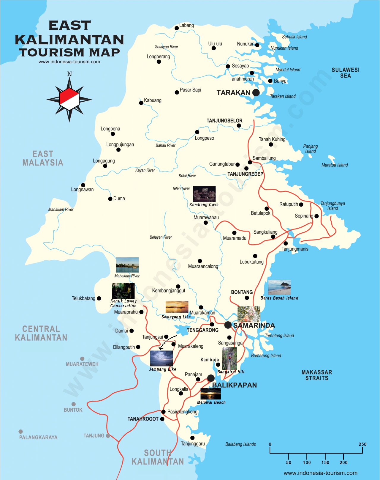
As a major producer of oil and timber, East Kalimantan at this moment is the most industrially advanced province in Indonesia. Oil, mining and logging bring prosperity to this province. Seasoned travelers might still be able to find adventures in relatively untouched places, and visitors who prefer comfort will find that most of the area here are pretty modernized. At the end of a drought in 1982, a fire raged in East Kalimantan for almost year, destroying 33,700 square kilometers (13,000 square miles) of forest. It was the largest fire ever recorded.
East Kalimantan (Kalimantan Timur) Province covers 129,067 square kilometers. Its population grew from 2,840,874 in 2005 to 3,550,586 in 2010 to 3,422,676 in 2015. The population density (people per square kilometer) is 26.5, The provincial capital is Samarinda, and the largest city is Balikpapan. East Kalimantan became a separate province in 1956.
Getting There: Balikpapan is the gateway to East Kalimantan; Garuda Indonesia Airlines fly from Kuala Lumpur to Balikpapan via Jakarta. Balikpapan can be reached by flight directly form Jakarta, Manado and Surabaya as well as form Tarakan. Food: Sea food is a must here. Most of the places offer halal food due to Islam influence. Various dishes in Chinese style can be enjoyed with reasonable price.Tourism Office: Jl. Kusuma Bangsa, Balaikota Samarinda 75123, Tel. (62-541) 741669, 731447, fax: (62-541) 636866
Balikpapan
Balikpapan is the largest city on East Kalimantan, Home to about a half million people, it is the base for Kalimantan’s oil industry. There is large oil refinery and a number of fancy hotels with the air conditioning turned on at full tilt. There is also a fairly large number of bars and nightclubs that cater to oil and refining industry workers enjoying some R & R. There are many ex-pats. Wanariset Orangutan Reintroduction Center is for rehabilitating orangutans. It is not open to the public.You will find many hotels in various categories Sudirman, Marsma Iswahyudi and Mulawarman streets. Restaurants can also be found on these streets. Melawai Beach is favorite hang out. It is relatively quiet in the afternoon. It comes alive at night as it is main night eating and drinking area.
Melawai Beach is a popular gathering place as it is situated at the city center and is close to Semayang Por. Swimming at the beach may be a little dicey with all the industry around. It is better place for watching the loading and unloading activities at the port, watching ships moving in and out, and enjoying various types of foods and drinks. During low tide, visitors could walk to Babi island, which is situated in the middle of Melawai Beach.
The capital of East Kalimantan is Samarinda but its main entry point is at Balikpapan. Its main airport is Sepinggan at Marsma Iswahyudi street. Sudirman street the a main road in different parts Balikpapan. Public buses nos 5 and 6 run along the road and pass Melawai Beach.
Beaches and Attractions in the Balikpapan Area
Melawai Beach is a main beach along Sudirman street in Balikpapan. It is a favorite tourist destination in the city center for the local community in Balikpapan and for domestic and foreign tourists. This beach is situated between Semayang Port and Banua Patra Beach. Walking along Melawai Beach is possible. Many restaurants, warungs and food hawkers pop up on Melawai Beach at nights. Among the things you can get are pecel lele (fried catfish with peanut sauce), pecel ayam (fried chicken with peanut sauce), chicken satay, bakso, fried noodles, fried rice, bandrek (hot ginger drink), wedang jahe (ginger drink), wedang ronde (ginger drink served with peanuts and rice flour balls), and many juices. Several traders also sell local specialties such as gapit banana.
Manggar Beach (22 kilometers from Balikpanan) is more of a real beach where people go to swim and enjoy water and beach activities. It is a favorite beach for locals, expats and tourists, especially on weekends and during holidays. This 13,000-square-meter beach is clean and has many facilities for visitors Manggar Beach is easy to reach. It is situated nine kilometers from Sepinggan on Mulawarman street, Manggar subdistrict, Balikpapan Timur district. There are many signs in Bahasa Indonesian. By car it takes only 20 minutes to get to. You can also take public transportation: the no. 7 bus from Damai bus station and walk 200 meters to the beach.
Wanawisata Forest is a large park with various types of endangered species of Kalimantan trees. It is a popular picnicking area for families during weekends. This park is open daily from 8:00am to 5:00pm. Its entrance fee is only Rp.1.000 per person. Wanawisata Forest is situated 300 to 400 meters away from Sukarno Hatta street, kilometers 10. The gravel access road is a little rough. There are plenty shady trees and a hall, which sometimes hosts events. There are playgrounds for children and tiny zoo with sambar deer and caged see monkeys
Teritip Crocodile Breeding Center

Teritip Crocodile Breeding Center (28 kilometers from Balikpapan) is a breeding center with the highest number of crocodiles in East Kalimantan. As of 2015, there were more than 1,700 crocodiles — including estuary crocodiles (Crocodylus porosus), and two endangered species i.e. fresh water crocodiles (Crocodylus siamensis) and supit crocodiles (Tomistoma segellly) — reside there. These crocodiles are bred in dozens of cages covering a 5 hectare of area. These cages are categorized into four types i.e. cubs, weigh gaining process, young crocodiles and mothers. Each visitor should pay only Rp10,000 per person. It is open daily from Monday through Sunday from 8 am to 5 pm local time. In addition to crocodiles, there are cages with snakes and monkeys. There are or used to be two Lampung elephants on which people could ride.
Various crocodile skin products are on sale. A small restaurants crocodile meat satay for Rp3,000 per stick here. Allegedly, this satay will increase your strength and vigor. Crocodile genitals are also sold for Rp400,000-Rp700,000. Men eat them to increase their virility. Please note that crocodile satay, genitals and oils are only available during weekends and public holidays. Crocodile oils are taken by people with skin diseases.
Visitors can also feed these crocodiles with fishes and chickens Teritip Crocodile Breeding Center is situated at Mulawarman street no. 66, Teritip village, Balikpapan Timur sub-district, East Kalimantan 76118. Tel: 0542-790568. It takes about 20 to 30 minutes to drive there. You could also take public transportation no. 7 from Damai bus station, Balikpapan.
Samarinda
Samarinda(two hours by bus from Balikpapan) is the capital of East Kalimantan. It lies on the banks of the Mahakam River and the most populous city on the entire Borneo island, with an estimated population of 842,691, up from 726,223 at the 2010 Census. Although it is the capital of East Kalimantan, some government institutions such as the Police, Indonesian Army District VI Of Tanjung Pura, and Pelabuhan Indonesia (Port Transportation) are also located in the city.
Samarinda has traditionally been to logging and timber was Balikpapan is to oil. It is the home of a number of timber and wood processing factories. The biggest attraction in town is the local mall. Forty kilometers up river you come to Tennarong which has a museum in the old Sultan Palace. Samarinda is known for its traditional food amplang, as well as the cloth sarung samarinda. The city also has a bridge connecting its river banks, Mahakam Bridge. The city center is on one side and the other side is named Samarinda Seberang.
Samrainda is connected by Trans-Kalimantan Highway Southern Route. From Balikpapan to Samarinda, the highway runs in parallel with the first controlled-access expressway in Borneo, the Samarinda-Balikpapan Expressway, which has been under construction for some time and was slated to be operational by the end of 2018. The city is served by Aji Pangeran Tumenggung Pranoto International Airport, which replaced previous Temindung Airport. It is one of Kaltim's busiest airports in terms of passenger and cargo movements. It is the primary hub of Kaltim Airlines. The prominent coal loading port of Tanjung Bara (TBCT) lies about 160 kilometers to the north of Samarinda.
Pampang Cultural Park
Pampang Cultural Park (25 kilometers from Samarinda) is a Dayak cultural site. Members of the Kenyah Dayak groups settled here beginning in 1967 from their original hometown of Apokayan in Malinau district to have better access to education and fulfill their basic needs. Around than 800 Kenyah live in Pampang village. They put on a show every Sunday from 2:00 to 3:00pm. No shows are held on other days. The entrance fee is Rp 5.000 per person
The show is performed in a Lamin, a traditional Dayak longhouse. Usually, eight dances — such as the nyelamai sakai dance (welcome dance for guests), ajay (war dance), enggang terbang and berburu (hunting dances) — are performed in one show. If you visit village outside the show time you will only see the Kenyah community going about their daily activities. Before and after the show the villagers sell necklaces, bracelets, belts, skull-caps, hats, traditional clothings and their accessories, which are mostly made of beads and bamboos. One of its leading handicraft is oval-shaped bamboo bag. Price of this bag is about Rp 250.000-Rp 300.000. Visitors can also take a village tour on try local food. The village doesn’t have any restaurants or food food stall. You could bring along snacks and drinks for watching the show.
Pampang Cultural Park is situated in Pampang village, Sungai Siring, Samarinda Utara sub-district. It takes about 30 to 45 minutes to get there from from Samarinda on the Samarinda-Bontang trans road. If you take a public transportation, take those going to Pasar Segiri-Sungai Siring from Lempake bus station in Samarinda.
Kutai Game Reserve
Kutai Game Reserve (six hours by bus and baot from Samarinda) is 1,200 square mile park set amid logging areas. A mix of national park and logging zones, it is home to 10 species of monkey, the highest number in Asia. Other animals here include hornbills, green earthworms, leeches, gibbons, orangutans and giant squirrels. Oil found nearby; illegal logging is a problem. . Kutai is difficult to reach and the facilitoes are minimal.
Kutai National Park (KNP) embraces is a lowland tropical forest in East Kalimantan and covers an area of 198,629 hectares. The ecosystems include iron-meranti-kapur (Dryobalanops Spp.) woods, mixed dipterocarpaceae, mangroves and kerangsa. At Sangkima resort, visitors can see ironwood trees (eusideroxylon Zwageri) with a diameter of 2.47 meter. Visitors can also test their courage by taking a suspension bridge made of ironwoods. At Prevab resort, visitors can of orangutans.
To enter KNP, visitors should firstly report to KNP hall at Awang Long street, Post Box I, Bontang or the National Park Management Division of Sangkima. Sangkima and Prevab resorts provide accommodation for visitors. At Prevab you can cook your own food, adding some wild vegetables that grow near their hotels. Guided trekking is allowed using guides found at Sangkima or Prevab posts. Alternatively, you can also travel by river using a hired ketinting or motorboat.
Kutai National Park is situated in Kutai Timur and Kartanegara districts, and Bontang city. Sangkima is situated at kilometers 38 of Bontang-Sangatta road. And Prevab resort is situated near Swarga Bara village, kompleks KPC, Sangatta, Kutai Timur. If you plan to do trekking, please bring along extra clothes, insect repellant, flashlight and food supplies.
Mahakam River
Mahakam River is the main thoroughfare through East Kalimantan and the busiest river in Borneo. The main jumping off point is Samarinda. The goals of some travelers is to reach Nagaim which is 523 kilometers upstream. From here it an 18 hour trip by motorized canoe through rapids and gorges to Long Phagai. Under the right conditions, it is possible to make it all the way to Long Aapari, where you can trek to Tanjung Lokan on the Kapuas River in West Kalimantan and make your down river to civilization. How far you can travel is often dependent on how high the water is. Many towns on the river are built on wooden walkways that keep them above the water during the wet season. Many villages have guesthouses in the local longhouse were travelers can stay.
The Mahakam river is the biggest river in East Kalimantan province and Asia. It is 920 kilometers long, flowing from its upper stream in Kutai Barat to Kutai Kartanegara and Samarinda and empties into the Makassar Strait. It joins with the Tenggarong, Belayan and Lawa rivers. The Makaham River is very important for most inhabitants in the province as some areas are only accessible by it. The transportation of goods also depends on it.
The Mahakam river flows through three regions: Kutai Kartanegara and Kutai Barat districts, and Samarinda city. Most of its upstream areas are only accessible by ketinting or motor boat, or long distance water taxi (ship). Some of its downstreams places can reached by land transportation. You can use motor vehicle to travel along the river passing through Samarinda city.
When traveling along the river, it is fun to watch daily life along the banks, the transport of goods, fishing and the sale of fishes. In Samarinda, in the afternoon, traders sell various types of foods and drinks along the river side. Residents usually watch sunset while enjoying roasted corns and breads. People like to come out at night when it is not so hot. Kumala island is situated in the middle of the river. It is a leading tourist attraction in Kutai Kartanegara district, where you can enjoy a sky tower, bumper cars and tourist cars.
Tenggarong: Home of the Kutai Sultan’s Palace
Tenggarong (60 minutes from Samarinda ) is the home of the Kutai Sultan Palace (Mulawarman Museum). After the Kutai Sultanate government ended in 1960, the Sultanam Parikesit lived in the 2,270-square-meter palace 1971. The Palace was then handed over to the East Kalimantan provisional government. In 1976, the place was made into a state museum called Mulawarman Museum. At present, Sultan Aji Muhammad Salehudin II is the 20th king of the Kutain sultanate.
Kutai Sultan Palace is well-maintained and in good condition and mostly white in color. The museum collections includes a royal throne, statues, jewelry, weapons, beds, a gamelan, and ancient ceramics from China, Jirat, traditional gravestones of Sultans and mostly made of long-lasting ironwood and crafted with Arabic letters. Among the sultans buried here are Sultan Muslihuddin, Sultan Salehuddin, Sultan Sulaiman and Sultan Parikesit. Only Sultan Alimuddin is buried in his own land in Gandek Mountain, Tenggarong.
The Kutai Sultan Palace is situated at Diponegoro street, Tenggarong, Kutai Kartanegara district in East Kalimantan. Tenggarong is easy to reach from Samarinda. Public transportation from Samarinda to Tenggarong is relatively plentiful. There are some food stalls in a special area. Most accomodation is in Samarinda.
Kumala Island Tourism Park
Kumala Island Tourism Park (in the middle of Mahakam River, accessible by boat from Tenggarong) is located on an 85-hectare island. Before it was transformed into a modern recreation site, it the home of hundreds of bekantan (Nasalis Larvatus) and various types of Borneo wild reptiles. Tourist Park of Kumala Island was developed since 2002. Entrance fee to this tourist park is Rp2,000 per person.
The Tourist Park of Kumala Island an amusement park with various rides and attraction. The most famous feature is the 78-meter-tall Sky Tower where visitors could see the whole island and Tenggarong. The hexagonal observation area at the top slowly rotates. Among the other attractions at the park are bumper cars, Lamin Beyoq, Lamin Mancong, and Lamin Wahau longhouses, a merry go round, the Lembuswana statue, fountain pond, and Pesut Lake
If you wish to stay in the middle of the island, the park management provides a rental cottage, complete with a swimming pool and catering service. There are food stalls selling nasi rames (rice combination platter) and bakso (meat balls) and various types of snacks. You can take a trip around the island in a tourist car for Rp3,000-Rp4,000 per person for each trip. If there is than less than five passangers, this car must be rented for Rp20,000.
Getting There: From Tenggarong you can take a ketinting or motorboat to Kumala island from a pier at Diponegoro street. It takes about five minutes to reach the island for Rp4,000 (if more than 5 persons) or Rp20,000 (if less than 5 persons) as you will be considered renting the boat.
Mahakam River Upstream from Samarinda
Tanjung Isu (upriver on the Mahakam river from Samarinda) is a little settlement around Lake Jempang with some Dayak longhouses that have been converted into lodges for tourists. The forest scenery and floating houses along the long river trip to Tanjung Isuy are excellent. The town is only 20 centimeters above the water level in the wet season. In the cemetery bodies are anchored to the ground to keep them from floating away in a flood.
Sick people are often cured by a belian, or shaman. Sometimes visitors are allowed to see the rituals which are accompanied by the frenzied music of gongs and drums. Sometimes the shows put on for visitors are a little touristy but are still interesting. Some travelers take a speed boat from Samarinda and visit for the day. It is worthwhile taking a trip to Mancong. There are impressive stretches of jungle and river. Hornbills, proboscis monkeys and other wildlife are often spotted if the boat doesn’t make too much noise.
Kersik Luway Nature Reserve (further upriver from Tanjung Isu near the town of Melak) is where the "Black Orchid" can be found as well as hosts of other plants and animals. Unfortunately much of the reserve has been damaged by fire. Other nature reserves and jungles areas can be found near the towns of Bontang and Bulungan.
Long Bagun is the end of the line for regular longboat transport from Samarinda along the Markham. The journey by local boat costs around $30 and takes three days, with an overnight stay in Long Iram. Between Long Iram and Long Began there is a community of Protestant Dayaks in Bdateh Bilnag and decent jungle trekking around the Kenyah settlement of Muara Merak. After Long Bagun one must trek through the jungle or hire boats to travel on a village-by-village basis. In Long Apari there is a longhouse village, from here it is possible to trek into West Kalimantan.
Kayan Mentarang National Park
Kayan Mentarang National Park (on the border with Malaysia) is a difficult-to-reach park that covers an area of 16,000 square kilometers and includes one of the largest tracts of undisturbed rain forest in Borneo. Cloud forests up to 2000 meters high and rare animals such as the clouded leopard and Malaysian sun bear are found in the park. It is also the home of nomadic and semi-nomadic Dayak tribes. It can only be reached by charter flight or a long arduous boat trip.
By some reckonings Kayan Mentarang National Park contains the biggest tract of primary secondary forest in Southeast Asia. Located in Bulungan, East Kalimantan, it embraces an area that ranges in elevation from 200 meters to 2,258 meters above sea level. It receives approximately 3,100 mm rainfall per year and generally has humid weather and average temperatures between 16°C and 30° C, depending on the elevation. Because of its geographical location, this national park is blessed with great biodiversity and a variety of ecosystems, ranging from lowland rainforest to Alpine bush. The best time to visit this national park is from September to December.
There are approximately 20,000 to 25,000 Dayaks — mostly Kenyah, Punan, Lun Daye and Lun Bawang — living in or in the vicinity of the park. Many kinds of archeological remains such as burial places and ancient stone monuments can be found in this national park. Among the best places to visit are: 1) Pulau Datok Beach and Lubang Tedong Hill, nice spots for sea cruising and swimming; 2) Matan and Simpang Rivers, ideal places for visitors to do an observation on archeological sites, or just having fun experience with the rapids of these rivers by longboat. One generally gets around the park on foot or cruising the rivers by longboat. Chartered motorized canoe costs about 180,000 IDR (US$20) per hour.
Wildlife and Plant Life in Kayan Mentarang National Park
A few plants found in the park are: pulai (Alstonia scholaris), jelutung (Dyera costulata), ramin (Gonystylus bancanus), agathis (Agathis borneensis), kayu ulin (Eusideroxylon zwageri), rengas (Gluta walichii), gaharu (Aquilaria malacensis), aren (Arenga pinnata), various types of orchids, forest palms, and Tropical pitcher plant or Kantong semar. Interestingly, several plants in the park have not been yet identified, and are considered new species.
There are 100 species of mammals (15 species of them are endemic), 8 species of primates, over 310 species of birds, and 28 species among them are Kalimantan endemic and have been registered by ICBP (International Committee for Bird Protection) as the endangered species. A few endangered animals are as follows: Clouded leopard/ macan dahan (Neofelis nebulosa), Honey bear/ beruang madu (Helarctos malaynus euryspilus), White Head Lamur/ lutung dahi putih (Presbytis frontata frontata), and Buffalo/ banteng (Bos javanicus lowi).
Good spots to observe wildlife: 1) Mount Palung (1,116 meters) and Mount Panti (1,050 meters), good places for hiking, observing flora and fauna, savoring the waterfalls, and camping; 2) Cabang Panti, a nature research center for the study of orangutans, gibbons, and leaf monkeys, with research station facilities, lodges, and library; Kampung Baru, where visitors can see proboscis monkeys.
Accommodation and Getting to Kayan Mentarang National Park
Kayan Mentarang National Park is in a remote area. It is possible to stay overnight in Dayak villages inside this national park. The villages can only be reached on foot. Camping in the forest can be done. In the Long Bawan area, there is a comfortable and clean guest house called Agung Raya Inn. It costs 50,000 IDR per night (5 USD). If you prefer to stay overnight in homestays, the rate ranges from 50,000 - 85,000 IDR per day and this includes 3 meals per day.
To get to Kayan Mentarang National Park can fly in on a small chartered plane from Samarinda, Long Ampung, Tarakan and Long Bawan. The flights take about an hour). DAS (Dirgantara Airline Services) and MAF (Mission Aviation Fellowship) offer flights but require advanced booking a minimum of one month before departing date. Both airlines reserve the authority to prioritize seats for local citizens from around the park. It is good to bring luggage less than 10 kg when flying with DAS (DAS
Another alternative is by boat from along Tarakan - Tanjung Selor - Long Pujungan routes. Cruising Mentarang River by speedboat will take around 6 hours, and smaller motorboats require one day to get there. Alternatively, for access to the southern part of this park, travelers can fly from Samarinda (East Kalimantan) or Malinau to Long Ampung Airport. From Long Ampung, the trip continues heading for Data Dian (Kayan Hilir Village), taking about 5 hours journey by boat. Since fuel is oddly expensive, boat cruising is considered costly, although travelers might find half the price when going with the locals on public boat, heading to Data Dian.
Sangkulirang — Mangkalihat Karst: Prehistoric Rock Art Area
Sangkulirang — Mangkalihat Karst: Prehistoric rock art area (on the Sangkulirang-Mangkalihat Peninsula on the east coast of East Kalimantan) contains thousands of rock painting, some of which are over 5,000 years old. The site was nominated to become a UNESCO World Heritage Site in 2015. According to a report submitted to UNESCO: “The property is situated in the midle-eastren part of East Kalimantan Province, at Sangkulirang-Mangkalihat Peninsula. It contains thousands of red rock-art paintings, and some sites with engraving located at 35 sites in seven different karst mountain areas at the head of the Sangkulirang-Mangkalihat Peninsula (Merabu, Batu Raya, Batu Gergaji, Batu Nyere, Batu Tutunambo, Batu Pengadan and Batu Tabalar). [Source: Permanent Delegation of the Republic of Indonesia to UNESCO]
“More rock art made by hunter-gatherers is found in Sangkulirang-Mangkalihat Peninsula than anywhere else in Southeast Asia. This seems to indicate that for thousands of years, from approximately 5.000 years ago. Sangkulirang-Mangkalihat Peninsula was an important meeting place in south part of the pre- Austronesian and Austronesian Migration.
The development of paintings in Sangkulirang-Mangkalihat Peninsula through thousands of years can be related to the end-glacial to the post-glacial land upheaval. In Sangkulirang-Mangkalihat Peninsula the changing landscape of prehistoric times is evident, and the position of the painting sites also provides a key to understanding the cultural area of rock a rt in the past, as well as the prehistoric chronological of Southeast Asian region.
The Rock Art painting shows communication between the world of the living and the worlds of the spirits, and gives insight in to the cosmology of prehistoric hunters and gatherers. There is an exceptionally high number of ‘tatto’ hand-print, composing handprint, unique human figures and fascinating representations of prehistoric social life, dancing, hunting, and rituals. Moreover, the Rock Art provides a unique testimony to the interaction of hunter-gatherers with the landscape. The panels show hunting and ritual journeys, and are thought to represent their landscapes mind. A wide range of big-mamals fauna is depicted (bos javanicus, cervus unicolor, sus barbatus, manis javanica), and also depicted already disappeared animal mammals like tapirus indicus.
Studies of material culture and cultural area are enriched by the many different artifacts shown on the Sangkulirang -Mangkalihat Peninsula sites. Good natural preservation conditions permit the study of rock art protection. Investigation of the large settlement and sites adjacent to the paintings gives a better understanding of the social context of the Rock Art. The Rock Art and the settlement sites demonstrate communication in prehistory not only with areas thousands of kilometers away, but also optimized using of karstic mountain environment.
The Rock Art of Sangkulirang-Mangkalihat Peninsula is an exceptional testimony of the aspects of prehistoric life, the savana environment and the activities of hunter-gatherer societies in the Kalimantan in prehistoric times. The wide range of motifs and scenes of high artistic quality reflect a long tradition of hunter-gatherer societies and their interaction with landscape, as well as the variation of their symbols and rituals from approximately 5.000 years ago. The dating research still in progress and it potentially these rock-art paintings could be older than 5000 year old, maybe even,10.000 years old. Most of the rich rock art images, the form and design, materials, techniques and location, have been preserved under cliff, and the chisel (or sharp tool) marks from their production thousands of years ago can still be studied and seen.
See Separate Article: EARLY HUMANS IN BORNEO factsanddetails.com
Image Sources: Wikimedia Commons
Text Sources: Indonesia Tourism website ( indonesia.travel ), Indonesia government websites, UNESCO, Wikipedia, Lonely Planet guides, New York Times, Washington Post, Los Angeles Times, National Geographic, The New Yorker, Bloomberg, Reuters, Associated Press, AFP, Japan News, Yomiuri Shimbun, Compton's Encyclopedia and various books and other publications.
Updated in January 2026