KILLER ERUPTIONS
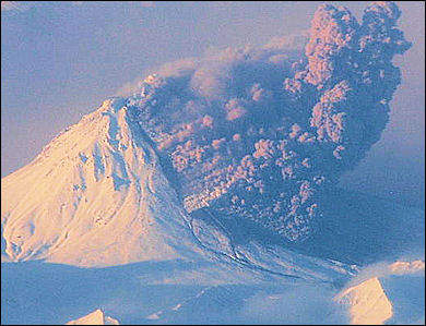
Pyroclastic flow from Kizimenby People generally die in eight different ways from volcanic eruptions: 1) by being buried under a landslide or a massive amounts of ash during catastrophic eruptions such as the ones that occurred at Mount St. Helens, Vesuvius, or Pinatubo; 2) by suffocating on ash during similar eruptions; 3) by being knocked on the head by rocks, known as volcanic bombs, hurled out of the crater; 4) by burning to death in a pyroclastic flow; 5) by drowning in a tsunami generated by the shock waves of a massive eruption such as the one that occurred at Krakatau; 6) by enormous landslides created when a cone is built up too steeply or part of the volcano collapses or breaks off; 7) by being buried or swept away by a lahar (See Below); 8) by dying of starvation when crops are destroyed by a blanket of ash.
People rarely die from flowing lava. There is usually enough time for people to get out of the way, but property is often lost when lava flows reach it. Generally the only people that die from lava are tourist who approach too close and fall in when recently hardened lava near a lava flow collapses.
Among the most destructive eruptions are ones in which the volcano collapses. Scientist break these down into three types: 1) lateral blasts like the one at Mount St. Helens, where a structural failure leads to a rock slippage around the magma that in turn leads to a sudden lateral explosion; 2) an early slide blast in which the rock slides but the explosion is upward rather than lateral; and 3) a non magma blast in which the release of gas and ash alone is enough to make a volcano collapse.
Sometimes the worst explosions occur after the initial eruption when a solidified lava domes plugs the volcano’s vent like the lid of a pressure cooker, causing pressure to build up in the vent and produce a huge explosion when it builds up to a critical level.
See Separate Articles VOLCANO COMPONENTS, STRUCTURE AND ACTIVITY factsanddetails.com ; TYPES OF VOLCANOES factsanddetails.com ; DESTRUCTIVE ERUPTIONS: LAHARS, PYROCLASTIC FLOWS AND GLACIAL BURSTS factsanddetails.com ; MAJOR VOLCANIC ERUPTIONS: LAKI, EL CHICHON AND THE ONE IN A MEXICAN CORNFIELD factsanddetails.com ; POMPEII AND HERCULANEUM AND ERUPTIONS OF VESUVIUS factsanddetails.com ; VOLCANO RESEARCH, STUDY, MONITORING AND PREPAREDNESS factsanddetails.com
Websites and Sources on Volcanoes: USGS Volcanoes volcanoes.usgs.gov ; Volcano World volcano.oregonstate.edu ; Volcanoes.com volcanoes.com ; Volcano Tourism volcanolive.com ;Wikipedia Volcano article Wikipedia , Smithsonian Global Volcanism Program volcano.si.edu operated by the Smithsonian has descriptions of volcanoes around the globe and a catalog of over 8,000 eruptions in the last 10,000 years.; Volcano Pictures Volcano Photo Gallery decadevolcano.net/photos ; Archive of Volcano Photos doubledeckerpress.com Book: “Volcanoes in Human History” by Jelle Zeilinga de Boer and Donald Theodore Sanders (Princeton University Press, 2002)
Pyroclastic Flows
A pyroclastic flow is a huge fire-ball-like wall of incandescent gas that rolls down a volcano like fiery avalanche. Often produced by the collapse of a lava dome inside the crater, they can travel more than 15 kilometers from a crater and reach speeds of 250 kilometers per hour. Temperatures inside one can reach 500̊C.
Mount Pelée is an active volcano and the highest mountain (1,384 meters, 4,575 feet) on Martinique, a French island in the Caribbean. In 1902, it erupted violently and killed 30,000 people in minutes, when a pyroclastic flow of flaming gas and ash hurled down the mountain. It was one for the worst volcanic disasters of all time. An extremely destructive eruption accompanied the growth of a dome at Mont Pelée. The coastal town of St. Pierre, about 4 miles downslope to the south, was demolished by an incandescent, high-velocity ash flow and associated hot gases and volcanic dust. Only two men survived; one because he was in a poorly ventilated, dungeon-like jail cell and the other who somehow made his way safely through the burning city. The prisoner who survived was regarded as the meanest man on the island and survived because he was locked in solitary confinement in the depths of a prison.
Lava domes are formed by relatively small, bulbous masses of lava too viscous to flow any great distance; consequently, on extrusion, the lava piles over and around its vent. A dome grows largely by expansion from within. As it grows its outer surface cools and hardens, then shatters, spilling loose fragments down its sides. Some domes form craggy knobs or spines over the volcanic vent, whereas others form short, steep-sided lava flows known as "coulees."
Viscid magma and lava domes are often associated with pyroclastic flows. The magma was viscid at Fugendake peak in the Unzen mountain range in Nagasaki Prefecture, where large pyroclastic flows occurred in the 1990s. A large lava dome was observed in the crater at that time, and was the source of pyroclastic flows for a long time. Sometimes the worst explosions occur after the initial eruption when a solidified lava domes plugs the volcano’s vent like the lid of a pressure cooker, causing pressure to build up in the vent and produce a huge explosion when it builds up to a critical level.
Pyroclastic Flow on Mt. Unzen in Japan
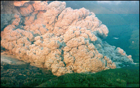
pyroclastic flow from 1991 Unzen eruption
On June 3rd, 1991, a violent volcanic eruption on Mt. Unzen in Japan produced a pyroclastic flow — a huge fire-ball-like wall of incandescent gas — that killed 43 people including two of the world's most famous volcanologists, the French husband and wife team, Maurice and Katia Krafft.
Despite warnings to evacuate, the mountain was filled with firemen, police, scientists, journalists and farmers. The Kraffts ascended the mountain from Shimabara to film small pyroclastic flows breaking loose from the lava dome on the peak of Unzen. On June 3rd they, an American volcanologist and several members of the Japanese media walked up an eroded valley on the side of the volcano, which had just begun erupting a few days before.
Witnesses said around 4:00pm the sky turned pitch black and houses on the slopes were swallowed up by black clouds, with occasional flashes of lightning. When the pyroclastic flow (PF) occurred there was a loud crack like the sound of a lightning bolt coming from the mountain. One farmer told Reuters, "There was a rain of fire from the sky — burning ash and rock — and I was afraid the car might explode. The air smelled burned. It was hard to breath."
Noel Grove wrote in National Geographic,"Lava on the top — gray on the surface but red hot underneath — broke loose and hurled down the mountain with hurricane force. The tumbling movement energized the lava into fragmentized clouds of killer heat. The three volcanologists plus journalists, cab drivers and farmers died instantly as the heat rolled over them...A subdivision evacuated just hours before the eruption began, was wiped out by flowing mud." [Source:Noel Grove, National Geographic, December 1992]
See Separate Article UNZEN VOLCANO AND ERUPTIONS factsanddetails.com
Tuyas, Glaciers and Sub-Glacial Volcanic Eruptions
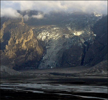
jökulhlaup at Gigjokull
in Iceland in 2010 Volcanic eruptions under glaciers are very dangerous. When the vent from the Eyjafjallajokull eruption in Iceland opened up beneath the glacier, the eruption suddenly became very violent. In a situation like that meltwater and magma produces huge volumes of steam, causing the volcano no to blow its top like a shaken soda bottle.
A tuya is a volcano that erupted under a glacier. The Vatnajökull glacier in Europe is a temperate glacier covering about 8,300 square kilometers in the SE part of Iceland. Volcanic fissure systems of the Mid-Atlantic Ridge plate boundary are partly covered by the western part of the ice sheet. Two major volcanic centers lie beneath the ice, the Bardarbunga volcanic centre and the Grimsvötn volcanic centre both with large subglacial caldera depressions. [Source: Nordisk Vulkanologisk Institut (Nordic Volcanological Institute, Iceland) Website, 2001]
Grimsvötn, together with Mardarbunga and Kverkfjöll, lie beneath the vast Vatnajökull icecap in east-central Iceland. Due to its subglacial setting and remoteness, the geology of Grimsvötn is poorly known. The volcano has a composite central caldera, of which the southern rim is the only exposed part of the volcano. Only basaltic material is known to have erupted from Grimsvötn. A large geothermal area in the caldera, with an estimated heat output of 5000 megawatts , continually supplies meltwater to an ice-covered caldera lake. Approximately every 4-10 years the accumulated water is released in glacial outburst floods (jökulhlaups) when the water level is high enough to lift its ice dam. Some jökulhlaups are associated with eruptions. In some instances it can be argued that the extra meltwater generated by a subglacial eruption triggered the draining of the caldera lake (for example, during the 1938 eruption). In other cases the sudden pressure release associated with draining may trigger an eruption. [Source: Newhall and Dzurisin, 1988, Historical Unrest at Large Calderas of the World: U.S. Geological Survey Bulletin 1855]
For more information on glacial outburst floods (jökulhlaups) see GLACIERS: TYPES, MECHANICS, STRUCTURES AND FORMATIONS factsanddetails.com
Glacial Bursts at Vatnajökull Glacier in Iceland
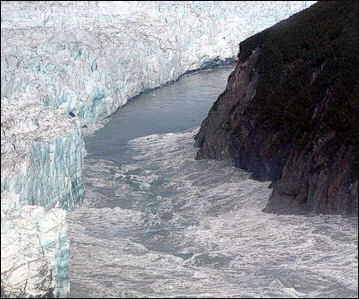
jökulhlaup at Hubbard Glacier in 2002 Glacial floods called jökulhlaup occur at Vatnajökull glacier from time to time as geothermal heat causes ice to melt and fill a lake inside a volcanic crater until it reaches a certain level and produces a flood. The debris and water released by these floods washes out roads and covers the coastal plains with boulders. Large floods cut off the south coast of Iceland from the rest of the country. [Source: Samuel W. Matthews, National Geographic, January 1987]
Thirteen glacial burst have occurred in the Grímsvötn region between 1955 and 1978. A catastrophic burst produced by Katla in 1918 released more water into the sea in a few days than the Amazon carries in a year.
"Vatna bursts about every two years, with a bad one every five years. " Icelandic glacier specialists Helgi Björnsson told National Geographic. "In between geothermal heat builds up a big pool or reservoir of meltwater, as much as a thousand feet deep. A ridge or rock holds it in, until suddenly it breaks open a channel under the ice, sometimes 30 miles long." In the future scientists are talking about building a tunnel after a glacial burst to drawn the water so it doesn't build up catastrophic proportions again."
In the fall of 1996, a volcano erupted underneath Vatnajökull glacier, an icecap that covers about 10 percent of Iceland's land mass. A 600-foot-deep chasm was melted through the glacier by heat, releasing ash and steam that billowed out of the chasm for two weeks. [Source: National Geographic, May 1997]
The eruption, one of the largest in Iceland this century, occurred along fissure located between major volcanoes — Grimsvötn and Bärdarbunga — after a series of foretelling earthquakes ripped open the earth that separated the ice from molten magma. Billions of gallons of meltwater was generated by the heat and a column of ash and steam rose six miles in the sky.
The movement of the massive amounts of meltwater caused parts of the glacier to collapse like shattered glass. A 500-foot-deep, two-mile-long canyon was cut into the glacier by water before it tunneled below the glacier and drained into a geothermically-warm lake in an ice-covered volcanic crater called Grimsvötn caldera. Government officials issued warning that a violent glacial flood, or jökulhlaup was imminent.
Vatnajökull Cataclysmic Flood in 1996
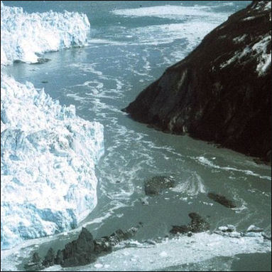
jökulhlaup at Hubbard Glacier in 2000 The Vatnajökull eruption produced a the worst flood in Iceland in 60 years. On November 5, 1996 several weeks after the volcano had quieted down, the sub-glacial lake reached its limited and released a torrent of black water that swept across a remote, treeless plain.
"The lake ordinarily rises 60 feet a year," a geologist told National Geographic. "But during the first days of the eruption it was rising 60 feet a day." The rising water lifted a 800-foot-thick cap covering the caldera. When this cap was broken off its footing and began to float, nearly a cubic mile of water was released, surging 30 miles to the glaciers.
The flood was so powerful 30-foot-high, 1000-ton boulders of ice were ripped off the glacier and deposited three miles away. A bridge built to withstand torrents of 317,000 cubic feet a second was washed by a surge that equaled the flow of the Congo, the world' second largest river.
No one was killed or injured but there was $15 million in damage, a hefty sum of money for a nation with only 265,000 people. Most of the damage occurred to the washed out bridge and the highway near the bridge, which was covered in gritty boulders of ice. Some scientists believe flood might actually help Icelandic fisherman by providing nutrients that could increase fish stocks offshore. A hydrologist who measuring river levels below the glacier when the flood began told an Icelandic radio station, "We had to run for our lives when it broke through. It picked up speed much faster than we expected."
Icelanders were not surprised by the eruption and flood. Since the Vikings arrived in 9th century, about 60 floods or similar magnitude have been recorded. One scientist skeptical of description of monstrous floods in the Vikings sagas told National Geographic, "Now we realize the stories are probably quite true."
Lahars
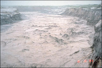
lahar on the east side of Pinatubo
A lahar is a mudflow or debris flow originating on a volcano. Lahars (also called debris flows or mudflows) are mixtures of water, rock, sand, and mud that rush down valleys leading away from a volcano. They can travel over 50 miles downstream, commonly reaching speeds between 20 and 40 miles per hour. Sometimes they contain so much rock debris (60-90% by weight) that they look like fast-moving rivers of wet concrete. Close to the volcano they have the strength to rip huge boulders, trees, and houses from the ground and carry them downvalley. Further downstream they simply entomb everything in mud. Historically, lahars have been one of the most deadly volcanic hazards. Lahars can form in a variety of ways, either during an eruption or when a volcano is quiet. Some examples include the following: (1) rapid release of water from the breakout of a summit crater lake; (2) generation of water by melting snow and ice, especially when a pyroclastic flow erodes a glacier; (3) flooding following intense rainfall; and (4) transformation of a volcanic landslide into a lahar as it travels downstream.
Lahars are often mudslide-like floods of rain-soaked ash that swamp and suffocate everything in their path. They often flow down major drainage channels, in some cases burying entire villages and towns in stinking, gooey mud. Lahars can ravage an area for years after the volcano erupted. Each year during the rainy season, new lahars are created that slide down slopes at speed up to 25mph and clog up river, swamp rice fields and smothers town and villages up to 35 miles away from the volcano.
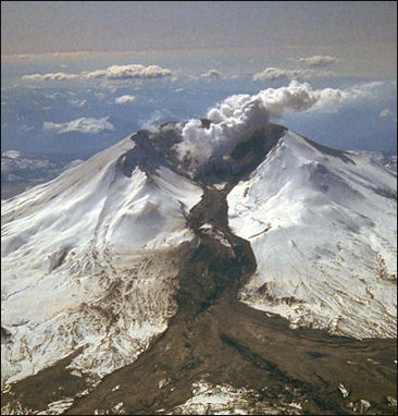
lahar from Mt. St. Helens in 1982 Lahars can travel to distances of 30 kilometers away from the crater. They can be hot or cold, and can move quickly or slowly. They often leave behind layers of mud that is like concrete when it hardens. Lahars can also occur when ice, mudflows and landslides are released on snow-capped volcanoes by an eruption or earthquake as was the case at Nevado del Ruiz in Columbia.
Sometimes the worse destruction can take place after the worst of an eruption has ended. When heavy rains follow an eruption a town that might have been spared by the eruption itself is sometimes swamped by a lahar. The town of Chaiten in southern Chile, for example, was spared when a volcano by the same name, 10 kilometers away, erupted but was inundated by a lahar 10 days later after heavy rains swelled a local river. Describing Chaiten after a lahar of soft gray mud buried half the town Alexi Barrionuevo wrote in the New York Times, “The scene was surreal...Houses were filled neatly to the roof with the gray material, some were broken in two by the weight of the sludge-filled water. A bus stood suspended in time on a main thoroughfare, buried to its windows. Where water once lined the banks of the town’s port , fishing boats now rest on the mud.”
See Separate Article PINATUBO VOLCANO AND ITS HUGE 1991 ERUPTION factsanddetails.com
Dangerous Eruptions and Snow- and Ice-Covered Volcanoes
Emplacement or flowage of hot pyroclastic rock debris on or into thick snowpacks on volcanoes can trigger hazardous rapid flows of sediment (including ice grains) and water. Such rapid flows can extend far beyond the flanks of a volcano, as has been observed at volcanoes in many parts of the world. Commonly these sediment-water flows achieve discharges and velocities that produce catastrophic consequences more than 100 kilometers downstream from source areas. The hazardous nature of such flows was most recently demonstrated in 1985 at Nevado del Ruiz volcano in Colombia, where snowmelt-generated sediment-water flows killed about 23,000 people. [Source: From: Pierson and Waitt, 1997, Introduction: IN: Pierson, (ed.), 1997, Hydrologic Consequences of Hot-Rock/Snowpack Interactions at Mount St. Helens Volcano, Washington, 1982-1984: USGS Open-File Report 96-179, 117p.
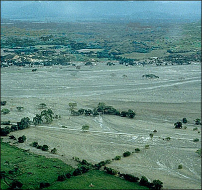
Armero smothered by Nevada Ruiz lahar Snow-covered stratovolcanoes like those in the Cascade Range and in Alaska commonly erupt explosively and produce potentially unstable lava domes. On such volcanoes volcanic explosions and mass failures from lava-domes are two primary mechanisms by which a hot rock having a large surface area is brought into contact with snow. Through this contact heat is effectively transferred to the snow, and large volumes of rapidly melted snow can trigger a variety of flows involving sediment (initially the hot volcanic debris) and water. Once triggered, the sediment-water flows are likely to erode and incorporate additional material from older deposits and thus increase in volume.
In addition to providing the heat to melt snow, stratovolcanoes commonly provide other conditions favorable to the initiation of sediment-water conditions favorable to the initiation of sediment-water flows: 1) high topographic relief and steep slopes; 2) the presence of poorly consolidated or unconsolidated, erodible pyroclastic rocks on slope surfaces; 3) and weakened structural integrity caused by hydrothermal alteration of rocks forming the edifice.
The details of interactions between hot pyroclastic rock fragments and snowpacks are poorly understood. Hydrologic consequences of eruptive activity are probably fairly common at snow-clad volcanoes but have largely gone unnoticed in the past owing to the remoteness of most such volcanoes, to the small-scale, short-lived nature of most of the phenomena, and to the sometimes enigmatic nature of deposits that once consisted partly of ice particles.
Nevado del Ruiz in Columbia
On November 13, 1985, the Nevado del Ruiz volcano in Columbia erupted, causing a massive volcanic mudslide called a lahar that flowed 30 miles down the mountain and killed 23,000 people, most of whom lived in Armero, a prosperous agricultural center known as the "white city." Only 3,000 of the city 23,000 inhabitants survived. An additional 3,000 people died in other valleys. It was the worst volcanic disaster in the history of the Americas. [Source: Bart McDowell, National Geographic, May, 1986]
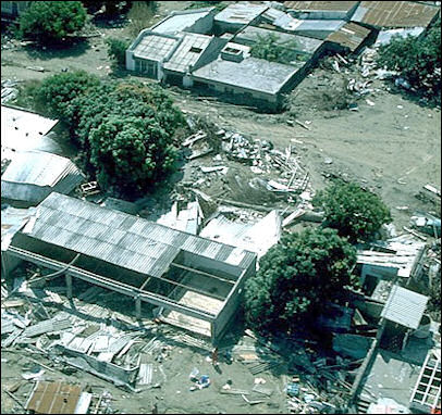
Armero mudflow and ruinsThe eruption was not particularly catastrophic. The lahar was caused by the ice and snow melted by the heat of the eruption. As it slid rapidly down the steep slopes of the volcano the water picked up soil and debris and flowed into narrow river valleys that concentrated the flow into a 130-foot high wall of mud and ash that eventually covered 16 square miles.
The lahar struck Armero at 11:00pm when most people were sleeping. With the consistency of mixed concrete, the acidy mud separated into two lobes, carried buildings away and smothered people under up to 10 feet of mud. Survivors made it to high ground in the middle of town. Victims were removed with bulldozers and buried in mass graves.
The disaster was not a total surprise. Minor earthquakes and small eruptions of gas and ash had been occurring for more than a year. The entire area had been surveyed by Columbian geologists but only people near the volcano were evacuated. The disaster could have even been worse. Only 10 percent of the glaciers and ice on Nevado del Ruiz melted.
Eyewitness Accounts of the Eruption and Lahar at Nevado del Ruiz in Columbia
The Nevado del Ruiz eruption occurred around 3:00pm. One survivor who lived near the volcano told National Geographic, "we heard an explosion and saw a column of ash"; a little past 9:00pm "it was stronger and the earth shook — not like a tremor, but a rocking motion." "Yes, at 9 it arrived like vengeance, and we believed everything would be destroyed — finished!" "The stones began to fall and it was also raining. "The stones were hot." Some were the size of soccer balls."
A survivor in Amero said ash began falling on the town at 5:30pm. It was "very soft, like sand" and had a "strong smell of sulfur." Later as the local radio station assured people there was no problem they watched television and went to bed. "Then one of my uncles came and said, 'Get the truck! Move the whole family out!' But another uncle said, 'No — get a hold of yourself!' And he went back to bed."
"At 11:05 the lights went out. I held matches to see my watch. And at 11:15 the mud came like a cloud. People screamed, 'The world is ending!' We ran upstairs to our terraces, but we saw another house collapsing. So we rushed outside, though my grandmother had just had an operation and could not run. A friend took my hand and dragged me faster toward a hill. I looked back and saw my grandmother and aunt and uncle embracing each other. I do not want to be selfish, but I only thought about saving myself. I ran. The mud would catch up, and we would run faster. When we reached the hill, we saw Armero disappear in 15 minutes."
The survivor spent three days on a hill without food or water and escaped after the mud had hardened. She went to a town searching for her family. "I cleaned mud from 29 bodies so I could recognize them," she said, "but none were my family. These are things of God."
Another survivor told National Geographic, the mud flow "came in circles like batter in a blender. It turned me inside the mud, then brought me out. I rode on top of the thing at a very speed, holding on to a car. And then it left me on the side of a hill." Another woman said she watched her children "floating like corks and screaming." Twice she reached out for her baby" and touched her little hand, but the mud made her slip away.
One man said he heard about a man who lost an arm and both legs. "When he learned that all his family had been lost, he used his good hand to cut his throat."
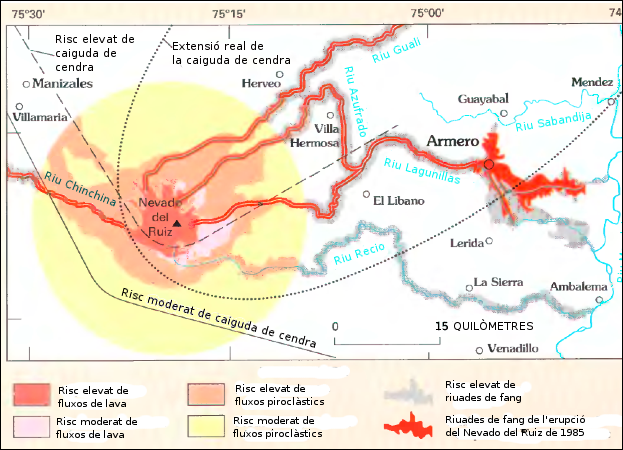
Nevado del Ruiz hazard map
Image Sources: Wikimedia Commons, United States Geological Survey (USGS)
Text Sources: United States Geological Survey (USGS), New York Times, Washington Post, Los Angeles Times, Times of London, Yomiuri Shimbun, The Guardian, National Geographic, The New Yorker, Time, Newsweek, Reuters, AP, Lonely Planet Guides, Compton’s Encyclopedia and various books and other publications.
Last updated April 2022
