DANGEROUS VOLCANOES
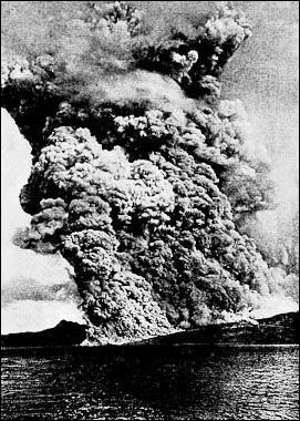
Pelee, Martinique, 1902 There are about 1,500 active volcanoes in the world today (not counting hundreds of undersea volcanoes). They are defined as volcanoes that have erupted in the last 10,000 years. An estimated half a billion people live within 60 miles of these volcanoes. Most are located on the same faults that produce earthquakes.
The world's dangerous volcanoes (as judged by their potential for a dangerous eruption and nearness to major population areas): 1) Merapi (Indonesia); 2) Taal (Philippines); 3) Unzen (Japan); 4) Sakurajima (Japan); 5) Ulawun (Papua New Guinea); 6) Mauna Loa (the United States); 7) Rainier (the United States); 8) Colima (Mexico); 9) Santa Maria/ Santiaguito (Guatemala); 10) Galeras (Columbia); 11) Teide (Canary Islands); 12) Vesuvius (Italy); 13) Etna (Italy); 14) Santorini (Greece); 15) Niragongo (Zaire). [Source: International Association of Volcanology and Chemistry of the Earth's Interior]
Websites and Sources on Volcanoes: USGS Volcanoes volcanoes.usgs.gov ; Volcano World volcano.oregonstate.edu ; Volcanoes.com volcanoes.com ; Volcano Tourism volcanolive.com ;Wikipedia Volcano article Wikipedia , Smithsonian Global Volcanism Program volcano.si.edu operated by the Smithsonian has descriptions of volcanoes around the globe and a catalog of over 8,000 eruptions in the last 10,000 years.; Volcano Pictures Volcano Photo Gallery decadevolcano.net/photos ; Archive of Volcano Photos doubledeckerpress.com Book: “Volcanoes in Human History” by Jelle Zeilinga de Boer and Donald Theodore Sanders (Princeton University Press, 2002)
See Separate Articles PINATUBO VOLCANO AND ITS HUGE 1991 ERUPTION factsanddetails.com ; TAMBORA: ITS MASSIVE ERUPTION IN 1815 AND HIKING THERE factsanddetails.com ; KRAKATOA ERUPTION AND TRAVELING TO ANAK KRAKATAU factsanddetails.com ; POMPEII AND HERCULANEUM AND ERUPTIONS OF VESUVIUS factsanddetails.com ; MAJOR VOLCANOES AND ERUPTIONS IN JAPAN factsanddetails.com
Worst Volcanic Eruptions
Worst Recorded Volcanic Eruptions (number of dead): 1) Mt, Tambora, Sumbawa, Indonesia, Apr. 10-12, 1815 (92,000); 2) Krakatoa, Indonesia, Aug. 26-28, 1883 (36,000); 3) Mt. Pelée, Martinique, May 8, 1902 (28,000); 4) Nevado del Ruíz, Columbia, Nov. 13, 1985 (23,000); 5) Mt. Vesuvius, Italy, Aug 24, 79 AD (16,000); 6) Mt. Unzen, Japan, May 21, 1792 (14,500); 7) Kelut, Java, Indonesia, 1586 (10,000); 8) Laki, Iceland, June 8, 1783 (9,350); 9) Mt. Kelut, Java, Indonesia, May 19, 1919 (5,000); 10) Mt. Vesuvius, Italy, Dec. 15, 1631 (4,000); 11) Mt. Papandayan, Java, Indonesia, Aug. 12, 1772 (3,000); 12) Mt. Lamington, New Guinea, Jan 17-21, 1951, New Guinea (3,000); 13) El Chichon, Mexico, May 28, 1982 (1,800); 14) Lake Nyos, Cameroon, Aug. 21. 1986 (1,700); 15) Mt. Taal, Philippines, Jan 30. 1911; 16) Santa Maria, Guatemala, Apr. 24, 1902 (1,000); 17) Mt. Pinatubo, Luzon, Philippines, June 15, 1991 (800); 18) Mt. St. Helens, May 18, 1980 (57).
Volcanologists rank large eruptions as: Level 5) like the ones at Mount St. Helens in 1980 and Mt. Vesuvius in the A.D. 1st century that occur every 10 years and release less than a hundred cubic kilometers of material; Level 6) like the ones at Mount Pinatubo in 1991 and Krakatau in 1883 that occur every 100 years and release more than a hundred cubic kilometers of material; Level 7) like the one at Tambora in Indonesia in 1815 that occur every 1,000 years and release more than a 1,000 cubic kilometers of material; and Level 8) like the ones at Toba 750,000 years ago and Yellowstone 2.1 million years ago that occur every 50,000 to 100,000 and release 2,500 to 3,000 cubic kilometers of material. The largest volcanic event known is an eruption in Colorado 28 million years ago that released more than 5,000 cubic kilometers of material.
A Level 8 is regarded as a supervolcano. The threat posed by a supervolcano is regarded as worse and ten times more likely to happen than an asteroid impact. If one were to occur today it could kill millions with the initial eruption and kill perhaps billions if a natural “nuclear winter” were triggered.
Great Laki Eruption in Iceland in 1783
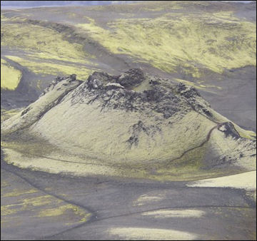
Laki in Iceland According to the Guinness Book of Records, the largest lava flow ever in recorded times was produced by an eruption of Iceland's Laki volcano in 1783. The lave flowed for eight months and covered an area of more than 500 square kilometers and reached a distance 40½-to-43½ miles from its source.
One the survivors, the Reverend Jon Steingrimsson wrote, "The flood of fire flowed with the speed of great river swollen with meltwater on a spring day. In the middle of the flood of a fire great cliffs and slabs or rock were swept along, tumbling about like large whales swimming, red-hot and glowing."
The 1783 Laki eruption released a cloud of sulfuric acid that weighed 90 million tons. The eruption itself killed few people but the cloud cover the land with deadly sulfuric acid that killed 75 percent of Iceland's crops and almost all the sheep and horses. The cloud itself and the famine that it produced killed about a forth of the people on Iceland.
"Those terrors that fell over and upon us I can hardly describe," Steingrimsson wrote. "It will be for all eternity a source of the greatest wonder, that any living thing should have survived." After eruption in entire Iceland was almost evacuated.
Thera Volcanic Eruption in 1645 B.C.
In 1645 B.C., a volcano on the Greek island of Santorini erupted with such force that some believe it caused the collapse of the Minoan civilization on the island of Crete, 70 miles away. Thirteen cubic miles of material exploded into the sky. Settlements on Santorini were buried under a thick layer of ash thicker than the one that covered Pompeii. [Source: William Broad, New York Times, October 21, 2003]
The main eruption was preceded by a smaller one — a shower of light pumice that buried the town of Akrortiri, down slope, under many feet of ash. This may have sent most of the residents away. No skeletons or human remains have been found on Santorini .
The main eruption began when sea water entered a vent of the volcano and mixed with magma and gases, producing an ultra-violent explosion. The center of Thera collapsed into a sea-filled caldera. Santorini was buried Pompeii-style under ash, up to 900 feet deep, that preserved frescoes and wall paintings that recorded everyday life from the period and contained Egyptian motifs.
See Separate Article THERA ERUPTION AND MINOANS factsanddetails.com
ParicutinThe explosion produced a huge tsunami, possibly 300 feet high. This tsunami swamped and hit the coast of North Africa, sending water 200 miles up the Nile. On Crete, an 50-foot-high tsunami wiped out coastal settlements. Inland ash may have ruined crops and grass that fed livestock.
The Thera eruption may have been the largest eruption on Earth in the last 10,000 years. Some scientists have calculated was 90 times greater than the one at Mount St. Helens and four times greater than Krakatau, which killed 36,000 people . Some say it was much larger than that, perhaps even larger than Tambora, which erupted in 1816 and produced the year without summer and famines in the United States.
Parícutin, Volcano Emerges from a Cornfield in Mexico
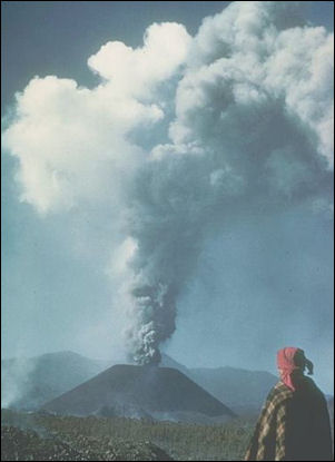
Paricutín Volcano (40 miles from Uruapan, 200 miles west of Mexico City) erupted from a cornfield after an earthquake on February 20, 1943, while the owner of the field, a peasant farmer named Dionisio Pulido, and his family looked on in horror. "For quite a while a small fissure in the field had been slowly growing long," reads a description of the event in a Reader's Digest's book called Natural Wonders of the World. "Suddenly the ground began to shake . The surface of the land around the fissure rose , and a hissing cloud of ashes, smoke and sulfurous fumes began to pour from the vent. Bt evening the rising cloud of smoke was visible in [the town of Parícutin, and during the night red-hot rocks were seen shooting into the air.
"The volcano grew with amazing speed, and geologists from all over the world rushed to the site for the opportunity to study a volcano from its birth. Within 24 hours of the first eruption, the remote Mexican cornfield was covered by a cone of ash 165 feet high. Before long lava also began to escape from the vent and spread over the surrounding countryside. Within a week Paricutin's cone reached a height of about 500 feet.
"Activity continued without cease in the weeks that followed. Incandescent rocks were hurled into the air providing a constant display of fireworks, and ash from Paricutín fell as far away as Mexico City. By April an advancing lava flow forced the evacuation of Paricutín, and in June another village three miles from the volcano also had to be abandoned completely. The Indian town of Parangaricutiro was covered by a lava flow. Only a tower from the San Juan church rise above the lava.
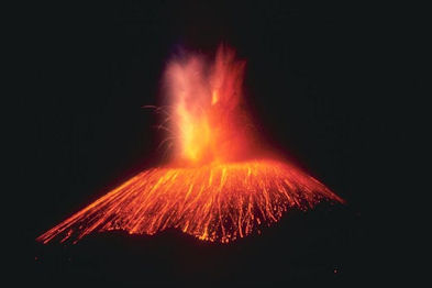
Paricutin"Particularly violent eruptions occurred in July and August. Then in October a subsidiary vent opened on the side of the main cone and added more lave to the flood. For the next two months or so, Paritucutín remained comparatively calm while its offspring named Sapichu continued with violent eruptions. When Sapichu died down, the fireworks resumed in the main cone. By year's end Paricutín had grown to a height of about 900 feet.
"Intermittent, sometimes explosive eruptions continued in the years that followed. At times huge chunks of rock and lava were hurled from the vent and landed are far as two miles away. Activity increased notably in 1951, with dozens of explosions occurring daily. Then just as suddenly as it had begin, Paricutín's activity abruptly ended. The last lava flow died out on February 25, 1952, just 9 years, 4 days and 12 hours after the volcano first sprang to life. The rim of the crater stood 1,345 feet above the remains of Señor Pulido's cornfield. Its lava flows had covered an area of 10 square miles and had engulfed two villages and hundreds of homes."
Mt. St. Helens
On March 27, 1980, Mount St. Helens Volcano in the Cascade Range, southwestern Washington in the U.S., reawakened after more than a century of dormancy and provided a dramatic and tragic reminder that there are active volcanoes in the "lower 48" States as well as in Hawaii and Alaska. The catastrophic eruption of Mount St. Helens on May 18, 1980, and related mudflows and flooding caused significant loss of life (57 dead or missing) and property damage lover $1.2 billion). Mount St. Helens is expected to remain intermittently active for months or years, possibly even decades.
Lyn Garrity wrote in Smithsonian magazine: Mt. St. Helens “set off the largest landslide in recorded history. Rock slammed into Spirit Lake, sending water up the hillsides and scouring the slopes down to bedrock. Another hunk of mountain spilled 14 miles down the North Fork Toutle River, burying the valley under an average of 150 feet of sediment. A blast obliterated, toppled or singed old-growth trees as far as 20 miles away. A column of ash soared 15 miles high, falling across 22,000 square miles. Flows of gas and rock at 1,500 degrees Fahrenheit surged down the slopes, incinerating all life in a six-square-mile area now known as the pumice plain. [Source: Lyn Garrity, Smithsonian magazine, January 2012]
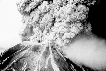
Mt. St. HelensThe eruption at Mount St. Helens is one of the most studied volcanic blasts and one of the few in which detailed photographs of the eruption itself exist. It was previously thought that an explosive blast from inside the mountains blew away the side of Mount St. Helens. A careful look at the photographs of the blast and the material left behind by the eruption, however, reveal that an enormous block of the mountain, including part of the summit, broke away first — perhaps jarred loose by an earthquake and pressure in the volcano — and that paved the way for the explosion.
Before the eruption at Mount St. Helens the block of mountains had acted as cork, holding the magma in the mountain. Its sudden removal depressurized the magma, causing a violent, sideways, explosion of rock, gas and ash. The blast destroyed everything in its path over a 180 degree, 230 square kilometers area. A fast-moving avalanche caused by collapsing mountain swept into Spirit Lake, causing an 850-foot-high tsunami that rose above the shore, scouring the mountainside down to the bedrock. The avalanche itself was so large it traveled down into a valley and then up over a ridge.
The horseshoe-shape crater left behind at Mt. St. Helens is found on other volcanoes, suggesting that these kinds of events are not uncommon. Examples of mountain collapse have found on more that 400 volcanoes in a variety of locations worldwide and are now regarded as the most common cause of large-scale eruptions. The destructive potential of these eruptions are higher now than ever because so many people lie on the path of a destructive blast or avalanche.
El Chichón Eruption in 1982
For most of this century El Chichón was an unremarkable jungle-covered 3900-foot hill in the Chiapas highlands of southern Mexico. Then, on April 4, 1982 it erupted sending a column of ash, rocks, and half of El Chichón, hurling 20 miles into sky. It was estimated than area equivalent to 100-kilometer-thick football field was ejected from the mountain. This was less than Mt. St. Helens, but what made El Chichón so potentially damaging was that it shot material high enough into atmosphere so that it would take years for it to come down. The result was enough material that once it circulated around the globe it lowered the earth's temperature by a fraction of a degree. [Source: Boris Weintraub, National Geographic, November 1982]
The 1982 eruption took every one by surprise. The last time El Chichón erupted was 1,200 years ago. It is a strange volcano to start with. In addition to being relatively small it is located fa away from the Pacific Ring of Fire in an area where there are no other volcanos. Scientists still don’t really understand what it is doing there. When it erupted it sent salt hurling into the atmosphere along with sulphur dioxide and ash, the first theat has ever been known to happen.
A worker at a seismic station who witnessed a pyroclastic flow said: "It startled me completely. The electrical activity was very intense; by lighting you could see the eruption going on. The noise wasn't very loud, just a low rumble, But the impressive thing about it is that appeared to come from everywhere." He saw a burning avalanche of ash heading his way. "it appeared to be heading very every close to us; reddish light appeared from about two kilometers away, it seemed. I learned later it was actually six kilometers away."
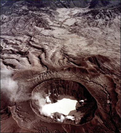
El Chichon An estimated 1,800 people were killed. An exact figure was hard to come by censuses in this part of Mexico are imprecise. The figure could have been higher but smaller eruptions took place before the major event and villages near the volcano had time to evacuate. The event took place eight days before Easter and the day after the eruption was called Ash Sunday because of the amount of volcanic debris that fell on the landscape and in the air. Ash from the sky cam down like snow. People who had no idea what was going on thought they were being punished for their sins and the world was ending. A bishop had to come on the radio to explain it was a natural phenomena.
The village of Francisco León (two miles from the eruption) was the worst hit place. Most of the residents fortunately had been evacuated, but those that remained were all killed. The first body dug up two weeks after the eruption was a small boy clutching a puppy. Residents in Nicapa (four miles away) were also killed.
In the town of Chapultenango the roofs of the church, market, market, movie theater and many houses collapsed from the weight of the ash. "The fire started coming out of the sky," one resident said, "and we didn't know whether to leave or stay. Ash and sand were falling and rocks came through the roof like bullets. After the first time I repaired the roof. Then it all happened a second time.”
Refugees from the eruption were called the damnificados. Most were Indians of the Zoque tribe. Some managed to gather their cattle off the slopes of El Chichón and mae it safety. Most crops within a large radius of survived of El Chichon, and the coffee harvest actually increased in years afterwards.
Image Sources: Wikimedia Commons, United States Geological Survey (USGS)
Text Sources: United States Geological Survey (USGS), New York Times, Washington Post, Los Angeles Times, Times of London, Yomiuri Shimbun, The Guardian, National Geographic, The New Yorker, Time, Newsweek, Reuters, AP, Lonely Planet Guides, Compton’s Encyclopedia and various books and other publications.
Last updated April 2022
