PINATUBO
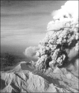
Pinatubo vertical eruption, 1991 Mt. Pinatubo (100 kilometers northwest of Manila and two hours by car from Angeles City) is a 1486 meter-high (4,875 feet) stratovolcano. Comprised of a complex of lava domes, it erupted catastrophically in 1991 after lying dormant for 400 years in what is considered the second most powerful volcanic event in the 20th century (the most powerful was Novarupta in Alaska in 1912). Dozens of villages were buried under tons of ash and mud. More than 800 people died during Pinatubo's eruption and more died from diseases in overcrowded evacuation camps.
According to volcanodiscovery.com: “Prior to the eruption, Pinatubo was a little known volcano. There were no known historic eruptions. Before the eruption in 1991 Pinatubo was 1745 meters high (about 250 meters more than now), and was only 200 meters higher than the nearby peaks, which are remnants of older volcanic edifices of Mt Pinatubo and hid it from views from distance. Pinatubo mostly noted for a failed geothermal development project. [Source: volcanodiscovery.com /*]
“Pinatubo is flanked to the west and probably underlain by by the Zambales Ophiolite Complex, an easterly-dipping section of Eocene oceanic crust which was uplifted in the late Oligocene. The second unit are sediments of the Tarlac Formation, mostly sandstone and siltstone in the older parts, and conglomerates and volcanic sediments and dikes in the younger. The Tarlac formation is found in the north, east and southeast of Pinatubo and formed contemporary with the oldest known volcanic centers in the area, including Mount Mataba or the diorite of the Dizon Mine, the sub-surface remnant of an ancient vent. The ancient volcanoes of the Tarlac Formation originated from the same east-dipping subduction along the Manila trench that continues to the present. /*\
“Ancient Pinatubo: Pinatubo was formed in 2 stages. The ancestral Pinatubo started to form about 1 million years ago, and built an andesite - dacite stratovolcano whose center was at the same location as today. Remnants of this precessor are seen in the ancient 3.5x4.5 wide caldera. Ancient Pinatubo had a number of flank vents, that formed the domes of Mount Negron, Mount Cuadrado, Mataba, Bituin plug, and the volcanic plug of Tapungho. Deep erosion in the Sacobia, Porac, Marimla, and Porac River valleys, and weathering of the lavas suggests that activity of the ancestral volcano ended several tens of thousands of years (or more) before the caldera-forming eruption and initial growth of the modern Pinatubo (ca. 35,000 years ago). /*\
“Modern Pinataubo: After the 1991 eruption, scientists (mainly from PHILVOLCS & USGS) carried out intensive fieldwork on the deposits of present-day Pinatubo to analyze its eruptive history. They distinguished at least 6 eruptive periods of modern Pinatubo, characterized by repeated, large explosive eruptions.” /*\
See Separate Articles: Hiking on Pinatubo See CENTRAL LUZON factsanddetails.com; VOLCANOES IN THE PHILIPPINES factsanddetails.com ; PINATUBO VOLCANO AND ITS HUGE 1991 ERUPTION factsanddetails.com VOLCANO COMPONENTS, STRUCTURE AND ACTIVITY factsanddetails.com ; TYPES OF VOLCANOES factsanddetails.com ; VOLCANIC ERUPTIONS: TYPES, PHASES AND CAUSES factsanddetails.com ; DESTRUCTIVE ERUPTIONS: LAHARS, PYROCLASTIC FLOWS AND GLACIAL BURSTS factsanddetails.com
Websites and Sources on Volcanoes: USGS Volcanoes volcanoes.usgs.gov ; Volcano World volcano.oregonstate.edu ; Volcanoes.com volcanoes.com ; Wikipedia Volcano article Wikipedia , Smithsonian Global Volcanism Program volcano.si.edu operated by the Smithsonian has descriptions of volcanoes around the globe and a catalog of over 8,000 eruptions in the last 10,000 years.
Past Eruptions of Mount Pinatubo
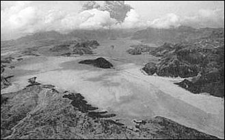
valley filled in by pyroclastic flows at Pinatubo, Pinatubo has had at least 6 periods of activity with large explosive eruptions in its past 35,000 years prior to the 1991 eruption. The 1991 eruption in this context actually ranks as one of the smaller eruptions. An eruption, which occurred 35,000 years ago and probably created the caldera, was likely much bigger. Pinatubo volcano eruptions: 1992, 1991 (Plinian eruption), 1450 ± 50 years, 1050 B.C. ± 500, 3550 B.C. (?), 7030 B.C. ± 300, 7460 B.C. ± 150, 15,000 B.C., 33,000 B.C. [Source: [Source: volcanodiscovery.com /*]
1) Inararo Eruptive Period — more than 35,000 14C yr B.P. The largest eruption in the history of modern Pinatubo occurred 35,000 (radiocarbon) years ago. It deposited up to 100 m or more of pumice and ash flows on all sides of Mount Pinatubo. 2) Sacobia Eruptive Period — ~17,000 yr B.P. A phase of explosive eruptions occurred 17,000 years ago and produced 2 debris flow deposits which are visible on the north bank of the Sacobia River.
3) Pasbul Eruptive Period — ~9,000 yr B.P. A large explosive eruption occurred ca. 9000 years ago. It produced pyroclastic-flow and tephra-fall layers exposed along the road between Sitio Pasbul, Camias, Porac, and the Gumain River. The pyroclastic flows overtopped the southeastern rim of the Tayawan caldera and nearly or completely filled the valley of the Gumain River.
4) Crow Valley Eruptive Period — ~6,000-5,000 yr B.P. Large eruptions 6,000-5,000 years ago produced pyroclastic flow deposits on both sides of upper Crow valley. 5) Maraunot Eruptive Period — ~3,900(?)-2,300 yr B.P. Eruptions in this period produced pyroclastic flows and lahars. 6) Buag Eruptive Period — ca. 1450 A.D. The last activity cycle prior to the 1991 eruption was in 1450 ± 50 AD. It produced pyroclastic flows that entered all valley of Pinatubo except the Gumain and Porac rivers.
Massive Eruption of Pinatubo in 1991
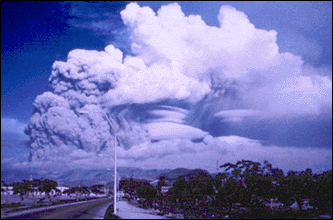
Pinatubo, June 1991 The eruption of Mount Pinatubo in June 15, 1991 was the second largest volcanic eruption of the 20th century, and considerably larger than the one at Mt. St. Helens. More than 1,000 people were killed. There were 847 deaths around the time of the eruption and scores died in landslides and lahars afterwards. Pinatubo left 650,000 homeless and destroyed some of the best rice-growing land in the Philippines.
The blast was strong enough knock off the top 250 meters of 1,745-meter-high, 5,770-foot-high Mt Pinatubo and make the daytime in the Philippines seem like night. One villager said it was like “a stampede of 100,000 animals.” The National Geographic journalist Noel Grove described it as "a monstrous cannon, firing a shot with effects felt around the world."
No one had any idea that Pinatubo was going to erupt with such ferocity. It had been dormant for between 460 to 500 years and the only sign that something was going to happen was gas that started leaking out of the mountain two weeks before.
Ten billion cubic meters—roughly two cubic miles—of ash, rock and debris was hurled into the atmosphere from Pinatubu in a three day period. This is enough material to bury the District of Columbia to a level of 150 feet. Fist-size rocks and debris rained down for weeks. The layer of ash that was deposited was described as a giant sand trap.
In Manila, ash fell that was said to be like powdered beige snow. To keep the stuff out of their eyes, pedestrians walked the streets with plastic bags stretched over their heads. But ash was not the only problem in Manila the day the volcano erupted. Around 7:00pm earthquakes hit. The exit of the lava from the mountain had left a subterranean cavern that began falling in on itself, causing shocks. In Manila, light fixtures swayed overhead and, according to Grove, “chairs felt as uncertain as liquid.”
Pinatubo Sulfuric Acid Cloud
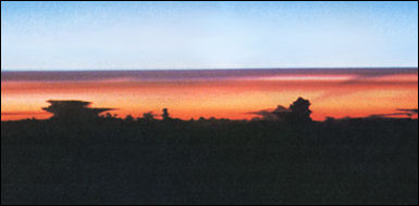
Pinatubo dust layer
Material from the Pinatubo eruption was hurled 25miles (40 kilometers) into the stratosphere. Layers of dust settles at around 100,000 feet and took years to dissipate. Around 20 million tons of sulfur dioxide made its way to the stratosphere, where it combined with moisture creating a thin aerosol cloud of sulfuric acid that girdled the globe within 21 days.
The layer of sulfate aerosol scattered light sunlight and absorbed heat from the earth, cooling the planet's surface. Pinatubo caused world temperature to drop about a half a degree. Scientists, measuring the depth of the cloud by satellite observation, calculate that 2 percent of the incoming sunlight was deflected from the earth by the layer of sulfate aerosol.
Damage By Pinatubo
Families within 15 miles of the crater said that rocks as big as grapefruits came hurling down from the sky and mud flowed into the houses. Piercing the darkness was strange-colored lightning—blue, green and even red. All told 42,000 houses were destroyed, 1000 acres of cropland buried under ash, billions of dollars in economic losses and nearly 1,000 dead. American geologists, who had arrived several months, had warned the populace that a catastrophic was going to occur or it could have been a lot worse.
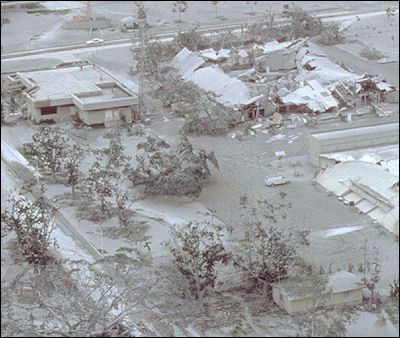
Pinatubo ash
Most of dead were crushed by roofs that collapsed under the weight of ash or were swept away by landslides or lahars. Carlos H. Conde wrote in the International Herald Tribune, “The spectacular eruption of the Pinatubo volcano in 1991 initially caused few casualties, thanks to the timely evacuation of almost everyone living within 30 kilometers, or about 20 miles, of the volcano. But on June 15, when the eruption reached its climax, Typhoon Yunya swept in from the Pacific, washing millions of tons of tephra—airborne ash—out of the sky. Of the 300 people killed by the initial eruption, most died when their roofs collapsed under the weight of the deposits, which fell like snow but congealed into something like concrete. Communities near Pinatubo are still suffering. Each year, heavy rains cause new flows of volcanic debris in the surrounding valleys, ruining cropland and displacing villages. [Source: Carlos H. Conde, International Herald Tribune, December 12, 2006 /]
Situated in central Luzon about 50 miles north of Manila, Clark Field sustained major damage when Mount Pinatubo erupted in 1991. The bases was decimated further when the U.S, Air Force pulled out after the eruption and looters ransacked the buildings. Clark is being transformed into a major international airport. It has two-mile-long runways that were made unusable by the ash from eruption that gets sucked into the engines during reverse thrusts and causes the ash to clog and freeze up the engines.
Worries About Volcanic Lake at Pinatubo
In August and September 2001, scientists became worried that a rain-swollen lake crater lake at Pinatubo might break through the crater walls and cause a catastrophic flood that might inundate villages and towns, killing lots of people and causing a lot of damage.
Some 25 million cubic meters of water was in the lake. With great fanfare engineers dug a ditch to drain water slowly from the lake and 40,000 people below the lake were evacuated. The water dribble down the ditch in a benign, dirty, brown stream that made many people wonder what all the fuss was about.
In 2004, the water in the lake suddenly turned a very dark brown and scientists tourists not drink it or swim in it. Ash from Pinatubo is now sold that is used in making building materials. Pumice stones are used in cosmetics, carpentry and washing stone washed jeans.
Lahars at Pinatubo
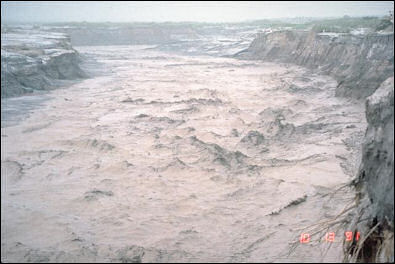
lahar on the east side of Pinatubo Most of the damage caused by Pinatubo was produced by lahars—mudslide-like floods of rain-soaked ash—that swamped and suffocated everything in their path. Lahars on Mr. Pinatubo flowed down eight major drainage channels, passing through farmland and villages and in some cases burying entire towns in stinking, gooey mud. The fact the eruption coincided with a typhoon didn't help matters. A five-meter-high wall built to slow down lahars was overtopped by a lahar which also carved out a 20-meter foot tunnel underneath the wall.
Lahars ravaged the Pinatubo for years after the volcano erupted. Each year during the rainy season, new lahars were created that slid down slopes at speeds up to 25mph and clogged up rivers, swamped rice fields and smothered towns and villages up to 35 miles away from the volcano. Scientists believe the lahars could keep being produced well into the 21st century.
The lasting effects of the lahars is much worse than the damage caused by Mount St. Helens. During the dry season, the landscape is barren and dusty and vehicles kick up huge clouds of debris when they pass by. In the rainy season the landscape turns to muck and vehicles have to make a seven hour detour. Eight rivers have been chocked by lahars, which means the water collects in large pools of stagnant green and smelly water.
The rain also causes river filled with volcanic silt to overflow their banks and flood fields and settlements with a gooey slurry of volcanic mud and water. When the volcanic material dries it forms a material as hard as concrete that have turned once productive rice fields into vast grey deserts.
One village and all of its rice fields were swallowed up by a gooey, sticky lahar right before the harvest season was to begin. In some places around Pinatubo, the layer of volcanic ejecta, sand and peddles and boulders is 30 meters (90 feet) thick.
Damage by Pinatubo Lahars
As of 1997, 9 billion cubic meters of lahar covered the area around Pinatubo, more than a 1,000 people had been killed and 1.2 million people (10 percent of the region’s population) were left homeless as a result of lahars. In 1995, alone, more than 100,000 people were forced to evacuate their homes as a result of lahars. Hundred of millions of dollars have been lost in lost crops.
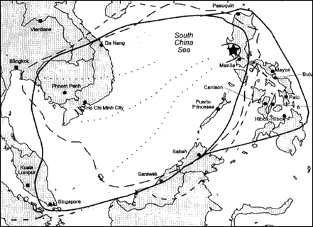
Tephra fall from 1991 eruption of Mt Pinatubo
In September 1995, Bacolor, a town with 65,000 people about 25 miles from Pinatubo, was buried under more than 27 feet of volcanic sludge from a lahar in less than four hours. People were plucked off of rooftops by army helicopters after the lahar hit. For a while Bacolor was a ghost town with houses and an 18th-century church buried up to their roofs under what became volcanic concrete. About 700 people had returned to Bacolor the next year. They live in shanties and sometimes climbed through a window near the choir in the church for service and to ring the church bell which sits at ground level.
Many people displaced by the lahars live around Dapdap (60 miles from Manila), where people live in homes and along streets made from the volcanic material that destroyed their homes. Many people have lost their homes and fields. As of the late 1990s few people had jobs and many made money from begging. When they went outside they wrapped themselves like bedouins for protection from volcanic dust and grit kicked up by the winds.
The government built dikes and dams to contain the lahars, but in 1995 many of these structures were swept away by volcanic mud. In places were the dikes worked, often lahars that were directed away from one community were simply directed towards another.
One scientist told the New York Times, "During the rainy season, residents of rival villages invoke the names of their patron saints to save them from the lahar flows. It is a competition to see whose saints are more powerful with God. This has been replaced by the more mundane struggle of committees who can pull strings and reshape the engineering projects."
Aeta and Mt. Pinatubo
Many Aeta—a Negrito tribe— live or lived around Mt. Pinatubo, the volcano that erupted violently in 1991. Traditionally, the Aeta sacrificed a pig with a bottle of gin into the volcano’s crater to placate Apo Malyari, the mountain god of Mt, Pinatubo and keep who live and work around the volcano safe. Apo Malyari is regarded as a combination of smoke, fire and earthquakes. According to legend he was unjustly trapped by lava under Pinatubo and escapes ever 400 or 500 years with great eruption.
Hundreds of Aeta died during and after the eruption of Mt. Pinatubo. Some of them died in the eruption itself. Others starved from a lack a food. Some of those who resettled in evacuation camps died of measles and other lowland diseases for which they had no immunity. Most of those that remained or were left behind in the villages died. Many who chose to hide out in caves rather than evacuate also died. The survivors were mainly those who evacuated far enough to get out of harms way.
The way of life of Aeta was dramatically changed after the eruption. The villages where they used to live are under meters of ash; trees that provided shade from the hot sun are gone; and their hunting grounds were closed. Many moved back to the mountain and grew what crops they could. The sandy soil made that difficult. Mountain rice turned yellow and withered when planted in the ash. Banana trees were about the only food sources that did well. But the Aeta complained they couldn’t live on bananas alone.
Many Aeta remained in evacuation centers that looked like refugee camps. In the 1990s they wore Western cloths, worked as laborers, collected banana blossoms and bartered the for rice, and attended classes that aimed to teach them how to make handicrafts.
See Separate Article NEGRITOS AND TASADAY factsanddetails.com
Image Sources:
Text Sources: New York Times, Washington Post, Los Angeles Times, Times of London, Lonely Planet Guides, Library of Congress, Philippines Department of Tourism, Compton’s Encyclopedia, The Guardian, National Geographic, Smithsonian magazine, The New Yorker, Time, Newsweek, Reuters, AP, AFP, Wall Street Journal, The Atlantic Monthly, The Economist, Foreign Policy, Wikipedia, BBC, CNN, and various books, websites and other publications.
Last updated April 2022
