TYPES OF VOLCANOES
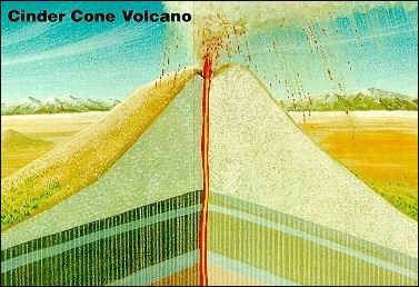
Cinder cone volcano Geologists generally group volcanoes into three main kinds: 1) cinder cones, 2) stratovolcanoes (composite volcanoes) and 3) shield volcanoes. Lava domes are typically regarded as a volcanic feature rather a type of volcano (See VOLCANO COMPONENTS, STRUCTURE AND ACTIVITY).
Cinder cones are the simplest type of volcano. They are built from particles and blobs of congealed lava ejected from a single vent. As the gas-charged lava is blown violently into the air, it breaks into small fragments that solidify and fall as cinders around the vent to form a circular or oval cone. Most cinder cones have a bowl-shaped crater at the summit and rarely rise more than a thousand feet or so above their surroundings. Cinder cones are numerous in western North America as well as throughout other volcanic terrains of the world.
In 1943 a cinder cone started growing on a farm near the village of Parícutin in Mexico. Explosive eruptions caused by gas rapidly expanding and escaping from molten lava formed cinders that fell back around the vent, building up the cone to a height of 1,200 feet. The last explosive eruption left a funnel-shaped crater at the top of the cone. After the excess gases had largely dissipated, the molten rock quietly poured out on the surrounding surface of the cone and moved downslope as lava flows. This order of events — eruption, formation of cone and crater, lava flow — is a common sequence in the formation of cinder cones.
During 9 years of activity, Parícutin built a prominent cone, covered about 100 square miles with ashes, and destroyed the town of San Juan. Geologists from many parts of the world studied Parícutin during its lifetime and learned a great deal about volcanism, its products, and the modification of a volcanic landform by erosion.
See Separate Articles PLATE TECTONICS factsanddetails.com ; VOLCANO COMPONENTS, STRUCTURE AND ACTIVITY factsanddetails.com ; VOLCANO BENIFITS AND GLOBAL IMPACTS factsanddetails.com ; VOLCANIC ERUPTIONS: TYPES, PHASES AND CAUSES factsanddetails.com ; DESTRUCTIVE ERUPTIONS: LAHARS, PYROCLASTIC FLOWS AND GLACIAL BURSTS factsanddetails.com ; MAJOR VOLCANIC ERUPTIONS: LAKI, EL CHICHON AND THE ONE IN A MEXICAN CORNFIELD factsanddetails.com ; POMPEII AND HERCULANEUM AND ERUPTIONS OF VESUVIUS factsanddetails.com ; VOLCANO RESEARCH, STUDY, MONITORING AND PREPAREDNESS factsanddetails.com
Stratovolcanoes (Composite Volcanoes)
Some of the Earth's grandest mountains are stratovolcanoes — sometimes called composite volcanoes. They are typically steep-sided, symmetrical cones of large dimension built of alternating layers of lava flows, volcanic ash, cinders, blocks, and bombs and may rise as much as 8,000 feet above their bases. Some of the most conspicuous and beautiful mountains in the world are stratovolcanoes , including Mount Fuji in Japan, Mount Cotopaxi in Ecuador, Mount Shasta in California, Mount Hood in Oregon, and Mount St. Helens and Mount Rainier in Washington.
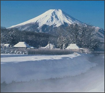
Mt. Fuji, an example of a stratovolcano Most stratovolcanoes have a crater at the summit which contains a central vent or a clustered group of vents. Lavas either flow through breaks in the crater wall or issue from fissures on the flanks of the cone. Lava, solidified within the fissures, forms dikes that act as ribs which greatly strengthen the cone.
The essential feature of a stratovolcano is a conduit system through which magma from a reservoir deep in the Earth's crust rises to the surface. The volcano is built up by the accumulation of material erupted through the conduit and increases in size as lava, cinders, ash, etc., are added to its slopes.
When a stratovolcano becomes dormant, erosion begins to destroy the cone. As the cone is stripped away, the hardened magma filling the conduit (the volcanic plug) and fissures (the dikes) becomes exposed, and it too is slowly reduced by erosion. Finally, all that remains is the plug and dike complex projecting above the land surface — a telltale remnant of the vanished volcano.
An interesting variation of a stratovolcano can be seen at Crater Lake in Oregon. From what geologists can interpret of its past, a high volcano — called Mount Mazama- probably similar in appearance to present-day Mount Rainier was once located at this spot. Following a series of tremendous explosions about 6,800 years ago, the volcano lost its top. Enormous volumes of volcanic ash and dust were expelled and swept down the slopes as ash flows and avalanches. These large-volume explosions rapidly drained the lava beneath the mountain and weakened the upper part. The top then collapsed to form a large depression, which later filled with water and is now completely occupied by beautiful Crater Lake. A last gasp of eruptions produced a small cinder cone, which rises above the water surface as Wizard Island near the rim of the lake. Depressions such as Crater Lake, formed by collapse of volcanoes, are known as calderas. They are usually large, steep-walled, basin-shaped depressions formed by the collapse of a large area over, and around, a volcanic vent or vents. Calderas range in form and size from roughly circular depressions 1 to 15 miles in diameter to huge elongated depressions as much as 60 miles long.
Subduction Zones and Stratovolcanoes
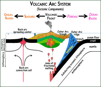
Volcanic Arc system At a subduction zones two tectonic plates collide head on, with one plate going over he top, forcing the other one down. In some cases the motion produces a descending convection current that sucks down the ocean floor. In these places deep seas trenches form; mountain building activity and earthquakes occur; and millions of tons of rock sink into the crust everyday. Subduction faults are usually angled at about 10 to 15 percent and often located where major oceans and continents meet. Where ocean crust, pushed down by the weigh of ocean water, is shoved under the thick crust of continents, the rock is heated, causing water and gases to bubble out. As they rise they melt the rock above it, creating magma that can fuel volcanoes. Subduction zones are also described as convergent boundaries (See Plate tectonics)
Subduction zone volcanoes are fueled by the heat generated from the friction of the two plates colliding together and the release of water and gases, which diffuses upwards and soaks into the mantle rock, causing it to melt and form magma.
Stratovolcanoes are found along subduction zones. Potentially dangerous, they are created by successive mountain building eruptions and can erupt on an annual basis or lie dormant for centuries and suddenly explode. Frequently erupting volcanoes are much less dangerous than those that lie quiet and build up pressure and finally explode with catastrophic force.
Subduction zone volcanoes are more explosive than rift zone volcanoes in part because their magma composition is different. The basalt that emerges from rift zone volcanoes is relatively uniform and fluid and tends to flow like a river. Conversely, the magma and lava found in subduction zones is less uniform and fluid. It is formed from the melting and merging of basaltic rock and sediments, mixed with water and goes, and tend to much more viscous. As a result it doesn’t move smoothly out of cracks or flow like a river like basalt does. Rather it congeals in the throats of the volcanoes, causing pressure to build up that can cause a massive explosion.
Evolution and Decay of a Stratovolcano
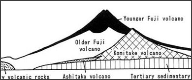
components of Mt. Fuji A. Magma, rising upward through a conduit, erupts at the Earth's surface to form a volcanic cone. Lava flows spread over the surrounding area.
B. As volcanic activity continues, perhaps over spans of hundreds of years, the cone is built to a great height and lava flows form an extensive plateau around its base. During this period, streams enlarge and deepened their valleys.
C. When volcanic activity ceases, erosion starts to destroy the cone. After thousands of years, the great cone is stripped away to expose the hardened "volcanic plug" in the conduit. During this period of inactivity, streams broaden their valleys and dissect the lava plateau to form isolated lava-capped mesas.
D. Continued erosion removes all traces of the cone and the land is worn down to a surface of low relief. All that remains is a projecting plug or "volcanic neck," a small lava-capped mesa, and vestiges of the once lofty volcano and its surrounding lava plateau.
Shield Volcanoes
Shield volcanoes, the third type of volcano, are built almost entirely of fluid lava flows. Flow after flow pours out in all directions from a central summit vent, or group of vents, building a broad, gently sloping cone of flat, domical shape, with a profile much like that of a warrior's shield. They are built up slowly by the accretion of thousands of highly fluid lava flows called basalt lava that spread widely over great distances, and then cool as thin, gently dipping sheets.
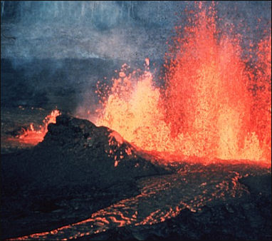
Kilauea eruption Lavas also commonly erupt from vents along fractures (rift zones) that develop on the flanks of the cone. Some of the largest volcanoes in the world are shield volcanoes. In northern California and Oregon, many shield volcanoes have diameters of 3 or 4 miles and heights of 1,500 to 2,000 feet. The Hawaiian Islands are composed of linear chains of these volcanoes including Kilauea and Mauna Loa on the island of Hawaii — two of the world's most active volcanoes. The floor of the ocean is more than 15,000 feet deep at the bases of the islands. As Mauna Loa, the largest of the shield volcanoes (and also the world's largest active volcano), projects 13,677 feet above sea level, its top is over 28,000 feet above the deep ocean floor.
In some eruptions, basaltic lava pours out quietly from long fissures instead of central vents and floods the surrounding countryside with lava flow upon lava flow, forming broad plateaus. Lava plateaus of this type can be seen in Iceland, southeastern Washington, eastern Oregon, and southern Idaho. Along the Snake River in Idaho, and the Columbia River in Washington and Oregon, these lava flows are beautifully exposed and measure more than a mile in total thickness.
Submarine Volcanoes
Submarine volcanoes and volcanic vents are common features on certain zones of the ocean floor. Some are active at the present time and, in shallow water, disclose their presence by blasting steam and rock-debris high above the surface of the sea. Many others lie at such great depths that the tremendous weight of the water above them results in high, confining pressure and prevents the formation and explosive release of steam and gases. Even very large, deep-water eruptions may not disturb the ocean surface.
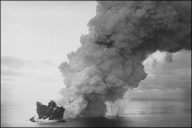
Surtsey eruption The unlimited supply of water surrounding submarine volcanoes can cause them to behave differently from volcanoes on land. Violent, steam-blast eruptions take place when sea water pours into active shallow submarine vents. Lava, erupting onto a shallow sea floor or flowing into the sea from land, may cool so rapidly that it shatters into sand and rubble. The result is the production of huge amounts of fragmental volcanic debris. The famous "black sand" beaches of Hawaii were created virtually instantaneously by the violent interaction between hot lava and sea water. On the other hand, recent observations made from deep-diving submersibles have shown that some submarine eruptions produce flows and other volcanic structures remarkably similar to those formed on land. Recent studies have revealed the presence of spectacular, high temperature hydrothermal plumes and vents (called "smokers") along some parts of the mid-oceanic volcanic rift systems. However, to date, no direct observation has been made of a deep submarine eruption In progress.
During an explosive submarine eruption in the shallow open ocean, enormous piles of debris are built up around the active volcanic vent. Ocean currents rework the debris in shallow water, while other debris slumps from the upper part of the cone and flows into deep water along the sea floor. Fine debris and ash in the eruptive plume are scattered over a wide area in airborne clouds. Coarse debris in the same eruptive plume rains into the sea and settles on the flanks of the cone. Pumice from the eruption floats on the water and drifts with the ocean currents over a large area.
Surtsey, the Creation of an Island
On November 14, 1963 a fishing boat saw some smoke rising from the sea. Thinking it was a ship on fire the crew went over to investigate and possibly help out. When they approached they saw a column of smoke as wide as a town shooting thousands of feet into the air. The plume was so large it created its own lightning. [Source: Sigurdur Thorarinsson, National Geographic, May 1965]
The plume, it turned out, was coming from a volcano that was rising up from the seafloor 450 feet below the surface and was trying to establish itself as an island. Named Surtsey after a Norse god who tried to set the world on fire the volcano erupted most violently in the first few days after it was spotted. At times 400,000 tons of ash spewed out every second creating a 50,000 foot column of ash, steam and smoke that could be seen 75 miles away in Reykjavík.
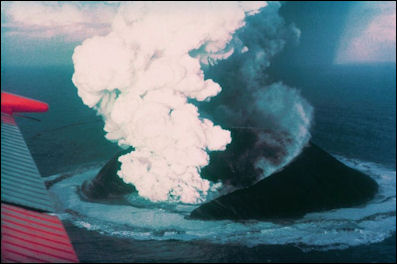
Surtsey eruption When the volcano had begun to establish itself as an island about three weeks after the eruption began three daredevil French journalists landed on Surtsey, took some pictures and managed to escape unhurt. Seven Icelanders for Westman Island — a fiercely independent people who didn't like the name Surtsey — landed a week later. They carried a marker that bore the name Vesturey — the name the Westman Islanders had selected — but were greeted with such a barrage of volcanic debris they never had time to plant the marker and barely escaped with their lives. In the end they decided that Surtsey was a fine name. Another group that waded through the surf to get to shore sank in waist deep quick sand and nearly drowned.
Icelandic volcanologist Gigurdur Thorarinsson arrived at Surtsey in February to plant the Icelandic flag. Although the volcano was relatively quiet when they set off from their mother ship rafts it starting erupting violently when they set foot on the island. Falling bombs of lava caused geyserlike explosions in the sea. To avoid getting hit Thoraninsson said he made an effort to stand still and stare skyward and watch the trajectory of the bombs. The trick he said was not to dodge them until a moment before they seemed about to land on our heads. The largest of these bombs were about a yard across. When they fell to the earth they punctured holes in the sand that filled with water that immediately started to boil from contact with the glowing bombs
The big question was whether or not the island was going to survive. not. While it only erupted ash and pumice — which are easily washed away by the surf — hopes were raised about its future when rivers of lava started spewing forth in a "Hawaiian type" eruption. In 1967 when the eruptions finally stopped Surtsey was three square kilometers in size. Since then strong winds and waves have reduced its size by a third. The chances are it will survive. The ash and pumice near the core of the volcano has already fused into hard rock, a process that scientist used to think took thousands of years.
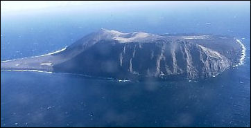
Surtsey in 1999 The eruption was a boon not only to geologists but also for biologist, who could study how life plants itself on a piece of land completely devoid of life. Twenty-five years after Surtsey's birth about 25 species of plants were, recorded, their seeds bourn by wind, floatied debris, carried by birds, or even attached to fish eggs that float ashore. Some species have failed to take hold but 18 still grow there, covering between one and two percent of the island. The sea sandwort, which first appeared in 1967, is the most common plant. Six species of seabirds breed on the island. [National Geographic Geographica, October 1980].
Surtsey is now very popular with popular with seabirds. Many even landed on the island while it was erupting to warm their feet. The birds are key to the islands survival. Their excrement provides fertilizer for the plants on the island which in turn help protect the island from eroding away. Birds are attracted to plants and sheltered area to raise their young. Scientists believe that Iceland is a bunch of Surtsey-like volcanos that joined together about 15 million years ago.*
Image Sources: Wikimedia Commons, United States Geological Survey (USGS); Volcano Research Center University of Tokyo (the Japan pictures); San Diego State University, U.S. Geological Survey (non-Japan pictures)
Text Sources: United States Geological Survey (USGS), New York Times, Washington Post, Los Angeles Times, Times of London, Yomiuri Shimbun, The Guardian, National Geographic, The New Yorker, Time, Newsweek, Reuters, AP, Lonely Planet Guides, Compton’s Encyclopedia and various books and other publications.
Last updated April 2022
