MAJOR VOLCANOES AND ERUPTIONS IN JAPAN
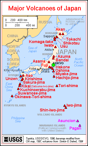
Japan is home to 108 of the world’s 1,500 or so active volcanoes, including more than 10 percent of the active volcanoes that are a threat to human populations. Volcanoes in Japan are ranked A to C in accordance with the degree of their volcanic activity, with A being the most active. Some A volcanoes have erupted 400 times a year. Mt. Fuji is classified as an active volcano even though it hasn't erupted since 1707.
Worst recorded volcanic eruptions (number of dead): 1) Mt, Tambora, Sumbawa, Indonesia, Apr. 10-12, 1815 (92,000); 2) Krakatoa, Indonesia, Aug. 26-28, 1883 (36,000); 3) Mt. Pelée, Martinique, May 8, 1902 (28,000); 4) Nevado del Ruíz, Columbia, Nov. 13, 1985 (23,000); 5) Mt. Vesuvius, Italy, Aug 24, 79 AD (16,000); 6) Mt. Unzen Japan , May 21, 1792 (14,500). [Source: World Almanac]
The world's dangerous volcanoes (as judged by their potential for a dangerous eruption and nearness to major population areas): 1) Merapi (Indonesia); 2) Taal (Philippines); 3) Unzen (Japan); 4) Sakurajima (Japan); 5) Ulawun (Papua New Guinea); 6) Mauna Loa (the United States); 7) Rainier (the United States); 8) Colima (Mexico); 9) Santa Maria/ Santiaguito (Guatemala); 10) Galeras (Columbia); 11) Teide (Canary Islands); 12) Vesuvius (Italy); 13) Etna (Italy); 14) Santorini (Greece); 15) Niragongo (Zaire). [Source: International Association of Volcanology and Chemistry of the Earth's Interior]
Two supervolcanoes erupted in Japan in the last 2 million years.
Bandai, a volcano in northeast Honshu near Fukushima, erupted with a huge catastrophic explosion in 1888 like that on Mt. St. Helens. Almost 1.6 billion cubic meters of the volcano’s summit collapsed, producing 1.5-kilometer-wide crater and releasing a high-speed avalanche that reached seven miles, engulfing several villages, killing 461 people and leaving behind huge piles of debris that blocked rivers and streams, turning valleys into large lakes. The whole process was similar to what occured on Mt. St. Helens in 1981.
Hikers have died on volcanoes in Japan after taking a wrong turn on a trail and being overcome by volcanic gases, In April 2009, a U.S. poet, Craig Arnold, disappeared after setting off on a hike on the volcanic island of Kuchinoerabujima, 50 kilometers off the cost of southern Kyushu. In June 2010, a 13-year-old girl died and three others were hospitalized after inhaling volcanic gasses near Sukayu hot springs in the Mt. Hakkoda area of Aomori.
The southern Kyushu prefectures of Kagoshima and Miyazaki are home to “shirasu” tablelands created by pyroclastic flows and layers of ash during the last 25,000 years. Shirasu is a type of volcanic ash and pumice peculiar to southern Kyushu. It is very fertile but because it can retain a lot of moisture it is associated can trigger landslides and mudslides in heavy rains.
See Separate Articles MAJOR VOLCANOES AND ERUPTIONS IN JAPAN factsanddetails.com; SAKURAJIMA VOLCANO AND MAJOR ERUPTIONS IN SOUTHERN KYUSHU factsanddetails.com; MT. ASO: ERUPTIONS, CRATERS AND HIKES factsanddetails.com; UNZEN VOLCANO AND ERUPTIONS factsanddetails.com; MT. FUJI: ITS GEOLOGY, ERUPTIONS AND RELIGOUS AND ARTISTIC IMPORTANCE factsanddetails.com; MT. ONTAKE AND ITS DEADLY 2014 ERUPTION factsanddetails.com; VOLCANO COMPONENTS, STRUCTURE AND ACTIVITY factsanddetails.com ; TYPES OF VOLCANOES factsanddetails.com ; VOLCANIC ERUPTIONS: TYPES, PHASES AND CAUSES factsanddetails.com ; DESTRUCTIVE ERUPTIONS: LAHARS, PYROCLASTIC FLOWS AND GLACIAL BURSTS factsanddetails.com ; VOLCANO RESEARCH, STUDY, MONITORING AND PREPAREDNESS factsanddetails.com
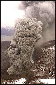
Usu March 2000 eruption Websites and Sources on Volcanoes: USGS Volcanoes volcanoes.usgs.gov ; Volcano World volcano.oregonstate.edu ; Volcanoes.com volcanoes.com ; Wikipedia Volcano article Wikipedia , Smithsonian Global Volcanism Program volcano.si.edu operated by the Smithsonian has descriptions of volcanoes around the globe and a catalog of over 8,000 eruptions in the last 10,000 years. Volcano Information in Japan: Volcano Research Center at Tokyo University eri.u-tokyo.ac.jp ; Wikipedia List of Volcanoes in Japan Wikipedia ; Smithsonian Volcanoes of Japan vulcan.wr.usgs.gov/Volcanoes/Japan ; U.S. Professor Disappears During Volcano Hike cnn.com/2009
Mount Asama: ; Wikipedia Wikipedia ; Asama Volcano Museum (Japanese language site) asamaen.tsumagoi.gunma.jp ; Unzen Government National Park Site National Parks of Japan ; Unzen Volcano University of Tokyo ; Unzen Tourism Unzen Tourism ; Mt Aso: Aso Volcano Disaster Prevention Council Aso Volcano Disaster Prevention Council Government National Park Site National Parks of Japan ; Aso Fan site Aso Fan Aso Tourist pamphlet (PDF) Aso Caldera Tourism ; Map Japan National Tourism Organization JNTO Japan National Tourism Organization (PDF) JNTO Aso Hiking Map Mappery.com
Sakurajima Tokyo University volcano site Volcano Research Center Wikipedia Wikipedia Geological map Geological Survey of Japan ; Mt. Usu Toya Usu Geopark Toya Usu Geopark ; Izu Islands Tokyo Islands tokyo-islands.com ; Wikipedia Wikipedia ; Wikitravel Wikitravel
Mt. Fuji: Good Photos of Mt. Fuji at Japan-Photo Archive japan-photo.de ; Mount Fuji Guide mountfujiguide.com/; Wikipedia Wikipedia ; Picture Tokyo picturetokyo.com ; Wikitravel Wikitravel ; Sacred Destinations sacred-destinations.com ; Fuji-Hakone-Izu National Park Government National Park Site National Parks of Japan ; Fuji Volcano /hakone.eri.u-tokyo.ac.jp ; 1707 Eruption PDF airies.or.jp ; National Geographic article news.nationalgeographic.com ; Getting to Mt. Fuji: Lonely Planet Lonely Planet Maps and Links live-fuji.jp ; Maps: Japan National Tourism Organization JNTO ; Climbers.org climber.org ; Volcanic Fuji: Fuji Volcano /hakone.eri.u-tokyo.ac.jp ; 1707 Eruption PDF airies.or.jp ; National Geographic article news.nationalgeographic.com
Mt. Usu
Mt. Usu (south of Tokyako Spa) is a 732-meter-high volcano that frequently erupts and has a cable car. The volcano became active approximately 20,000 to 15,000 years ago. Around it are numerous lateral cones. Mt. Showa-Shinzan — which was created through volcanic activity between 1943 and 1945 — is said to be a lava dome and has high value in both academic and scenic terms. In addition, Toyako Onsen was born when a wellspring opened up on the shore of the lake after the volcanic eruption of 1910.
Mt. Usu is a stratovolcano. The summit was torn off by an explosion about 7,000 to 8,000 years ago. A large mudflow in 1822 ripped through a town and killed 59 people. Pyroclastic flows occurred in 1769, 1822 and 1853. The 1822 eruption produced the 671-meter-high Ogarison peak. The 1853 eruption produced the 732-meter-high Ousu peak. Mt. Usu was the source of the 1910 Mt. Showa eruption. That year, some 45 craters opened up and one person was killed in a mud slide. There were also huge explosion caused by magma interacting with ground water.
Visitors can take the ropeway to the summit station, then walk to the crater floor observatory and along the southern outer-ring route, where you can see relics from past eruptions and the status of plant restoration. Konpira Crater and Mt. Nishiyama Crater were formed when Mt. Usuzan erupted in 2000. Footpaths have been built around the craters, enabling visitors to view not only the craters themselves but also roads and houses that were damaged in the eruption. Website: Toya Usu Geopark Toya Usu Geopark .
Recent Mt. Usu Eruptions
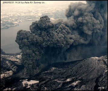
Mt. Usu erupts every 30 to 50 years. In August 1977, Mt. Usu erupted and caught people by surprise. A panicky evacuation ensued when the eruptions began. The 1977 eruption destroyed a cable car and rained rocks and 30 centimeters of ash on Toyako Onsen. Three people were killed in August 1978 by a mudflow after they returned to their homes, thinking it was safe. The eruption continued until 1982 and formed the 667-meter-tall Usu Shinzan peak on the crater basin.
In March 2000, Mt. Usu (Uzuzan) began erupting. Large amounts of superheated steam and gas were hurled as high as 3,200 meters into the air from craters on the lower slopes of the volcano. No one was hurt. More than 17,000 people were evacuated. Stones from eruptions fell on nearby towns. Since there was a large body of data on Mount Usu it was easy to predict its 2000 eruption four days in advance with telltale signs.
Even though craters opened up on a hill only 300 meters above the hot spring resort of Toyako Onsen during the Usu eruption no one was killed or hurt. This is because scientists were able to accurately predict the eruption and people were ordered to evacuate their homes for gymnasiums in nearby cities before the eruptions began.
Mt. Usu has a history of producing earthquakes before an imminent eruptions. So when a series of strong earthquakes rattled the mountain in 2000 an order was given for all people in the area to evacuate. Particularly urgency was given to moving people who lived along likely paths of mud slides and pyroclastic flows. Four days after the warning was given Mt. Usu erupted.
A total of 17,300 people were evacuated. About 13,039 of them long term. About a third of these people were allowed to return home after a couple of weeks. The others had to wait until the eruptions were largely over about a month later.
Miyakejima Eruptions
MiyakejimaIsland (120 miles south of Tokyo) is a volcanic island with a circumference of 36 kilometers and dominated by Mt. Hyotan and Mt. Oyama volcanoes. My. Hyotan last erupted in 1983, destroying 400 houses with reddish-black lava.
In July 2000, 813-meter-high Mt. Oyoma began erupting. One explosion sent smoke 15,000 meters in the air. All the 3,800 residents on the island were evacuated, mostly to neighborhoods in Tokyo. Eleven million cubic meters of volcanic ash fell on the island. In 2004, the island was still evacuated. Residents had been allowed to make short visits but the presence of dangerous volcanic gases made the island dangerous to live on.

In February 2005, people were allowed to return to Miyakejima even though the infrastructure was still damaged and poisonous gases were still being emitted from the volcano. Certain areas of the island were off limits. The residentss were give ¥4.5 million is disaster relief but were only allowed to spend a third of it to rebuild their houses. In April 2005, schools reopened on Miyakejima after 4½ years. Students went to school, carrying special belt bags containing gas masks. Efforts were made to revive the fishing, farming and tourism industries.
By 2007, wild birds and other animals had returned to Miyakejima but poisonous fumes were killing its famous trees and reducing once grand forest to grasslands. The Miyakejima volcano erupted in July 2005 and February 2006. An eruption in 1840 killed 11.
Mt. Asama Eruptions
Mt. Asama (on the border of Gunma and Nagano Prefectures) is a very active 2568-meter-high, three-fold composite volcano that erupted at least 50 times and has a large eruption every four or five centuries. In 1783, pyroclastic flows killed 1,151 people. In 1911 there were sporadic eruptions with numerous deaths. In 1930s there was some volcanic activity. Six died near the crater in 1930. There were three more deaths in 1931. In 1947, 11 mountaineers died after being hit by rocks and cinders from an eruption. In 1721 the same thing happened to 15 mountain climbers
In 1973, Asama erupted after being dormant for more than 11 years. Scientists recorded 4,000 small explosions in a four month period. Eruption in 1982 and 1983 sent ash beyond Tokyo Bat to the Boso Peninsula. There were minor eruptions with some ash fall in 1990 and again in April 2003. Today, tourists check out the blocks of solidified lava produced by eruptions in the Edo period in the 17th to 19th centuries.
Mt. Asama experienced a minor eruption in February 2009,. Smoke billowed more than 2,000 meters into the air and rocks were thrown more than a kilometer from the crater. Ash fell as far as central Tokyo and Chiba Prefecture. A warning of an eruption was issued two days before after swelling at the top of the volcano was detected and people were told not go within four kilometers of the crater. Scientists say there is a possibility of large eruption in the not too distant future as magma has accumulated in shallow area near the peak.
The summit area of Asthma is often closed due to worries about eruptions. Sometimes an area within a four kilometer radius is closed off and guards are posted on the trails to turn back hikers.
Mt. Asama Eruptions in 2004
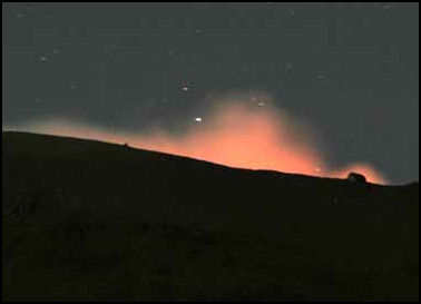
Asthma came to life in 2004, with four mid-size eruptions between September and November. Smoke and ash was hurled more than a mile into the sky, falling on Tokyo 90 miles away, and damaged crops n the vicinity of the volcano. Hundreds of tremors were recorded. Shocks from the eruption blew out windows at the Asama Volcano Museum near the base of the mountain, set off some forest fires, and forced the evacuation of some houses. A farm 20 kilometers norther of the carte was ht by a shower of rocks. No one was hurt.
Minor eruptions continued for several days, Lava spewed out the crater in fountains and poured down the slopes. A magma dome — first since 1982 — was formed. As of December 2004, Asama was still releasing 2,000 to 4,000 tons of gas a day and lava could be seen at the bottom of the crater
Asama erupted off and on until June 2005. A huge andosite boulder that was five meters tall and 5 meters deep and weighed 200 to 300 tons was ejected and came to rest about 200 meters from the crater. Scientist think it was part of a lid at the bottom of the crater that was smashed during the eruption. The boulder flew 170 meters, bounced once, leaving a 13-meter wide hole and stopped.
Mt. Fuji
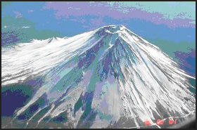
The precursor of Mt. Fuji — Mt. Komitake volcano — was created just north of Mt. Fuji between 200,000 and 700,000 years ago. Old Mt. Fuji erupted with extremely massive explosions about 100,000 years ago and grew out of the south side of Mt. Komitake. New Mt. Fuji emerge from Old Mt. Fuji about 10,000 years ago with eruptions that generated large amounts of lava. The huge lava flows on the flanks of the mountain date to this period.
Today Mt. Fuji is regarded as dormant but still active volcano. It has erupted off and on for the last 2,200 years, with 10 eruptions since A.D. 781 and a large one in 864. Most these eruption spewed large amounts of ash and modest amounts of lava, with eruptions from the summit alternating with eruptions from the slopes. . Eruptions on the slopes occurred on the northwest, northeast and southeast sides.
The last eruption occurred in 1707 between the 5th and 8th station. Smoke and ash were thrust 10,000 meters into the sky and an estimated 850 million cubic meters of stone, sand, and ash was hurled out. Three meters of debris accumulated at the foot of Mt. Fuji and six inches of ash blanketed Tokyo. More in the countryside between Mt. Fuji and Tokyo. There were no casualties but hundred of thousands of people fled the area with wooden buckets over their head. The eruption destroyed crops and farming areas. Famines and social upheaval lasted for 10 years.
See Separate Article MT. FUJI: ITS GEOLOGY, ERUPTIONS AND RELIGOUS AND ARTISTIC IMPORTANCE factsanddetails.com ; CLIMBING MT. FUJI AND DEALING WITH TOURISM ON THE MOUNTAIN factsanddetails.com
Future Eruption of Mt. Fuji
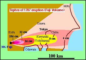
fall out from 1707 Fuji eruption There are concerns that Mt. Fuji may might erupt violently in the not too distant future. Concerns were raised when a series of low frequency temblors began early 2000 and reoccurred in 2001. These tremors sometimes indicate that magma is starting to rise. Some 15,000 people have participated in emergency drills at the foot of Mt. Fuji.
If Mt. Fuji were to erupt like it did in 1707 the damage could be terrible because many more people are living in the area of the mountain than in the 18th century. Such an eruption would produce a huge ash cloud that would blacken the skies over Tokyo and Yokohama. Highways, airports and rail services would be shut down. Lava flows could wipe out large residential areas, block major highways and shut down the railroads. With distribution networks disrupted, food supplies would start to run short and prices sky rocket. If rain falls, soggy ash on transformers could cause short circuits that would cause power failures.
Some geologist speculate that the volcanoes on Iwo Jima are ready to blow any time at the island my be the next Mt. St. Helens or Pinitabu.
The Izu volcano arc is regarded as dangerous. It could produce an explosive eruption that could produce a huge tsunami that could ravage Japan’s densely populated east coast.
Underwater Volcanoes off Japan
There are several underwater volcanoes in the seas off coast of Japan. The Ogasawara undersea volcano six kilometers north of near Minami-Iwojima Island erupted in July, 2005. It produced a kilometer-high plume of steam and a yellowish brown slick of mud and debris on the water surface. Some though it might become an island. The same volcano, also known as Fukutoko, erupted in January 1986 and produced a crescent-shaped 600-meter-in-diameter island that reached 15 meters in height before it was eroded below sea level by ocean waves within three months. Volcanic activity changes the color of the water around the volcano every year.
In February 2009, an underwater volcano erupted near Minami-Iwoto Island in the Ogasawara islands, 1,200 kilometers south of Tokyo, sending a huge cloud of smoke and ash rising in the air and changing the color of the sea to yellowish green. The volcano, known as Fukutokuokanoba, has erupted seven times since 1904. On three occasions land masses were formed that eventually were washed away by the sea.
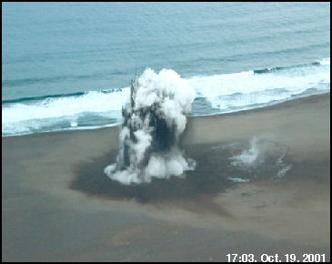
beach eruption on Iwo Jima Kenji Nogami, a volcano expert at Tokyo Institute of Technology, told the Yomiuri Shimbun, “In the 1986 eruption, a new island appeared after lava accumulated. The island was washed away by waves, but seabed upheaval reduced the water depth to 22 meters, It’s possible that this [recent] activity could fore a permanent island.”
Other Eruptions in Japan
There are 15 active volcanoes on Hokkaido. An eruption on Mount Takachi in 1926 killed 144 people. In 1995, a volcano named Mt. Komagatake that had been dormant for 54 years erupted six times between 1996 and 2000.
IwoJima — 1,250 kilometers south of Tokyo, halfway between the main islands of Japan and Guam — is where the famous World War II battle took place. Part of a group of volcanic islands called the Bonins, it is also very active volcanically. Some geologists speculate that the volcanoes on Iwo Jima are ready to blow any time and the island my be the next Mt. St. Helens or Pinitabu. Iwo Jima means “Sulfur Island. It rose 46 centimeters June 2006 and January 2007, growing 12 centimeters in one month in November and December 2006. This was more than it rose before it erupted in September 2001. Evidence of a steam explosion was seen late in 2007.
In April 2007, Ogasawara volcano was observed erupting off Minami Iwo Jima island. A fishing crew said it saw the water change color and observed volcanic smoke rising over a five-kilometer stretch of open water.
Monitoring Volcanoes in Japan
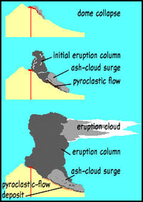
pyroclastic flows on Unzen The Coordinating Committee for the Prediction of Volcanic Eruptions monitors 108 volcanoes, with 41 of these receiving 24-hour attention.
The Japanese Meteorological Agency observes 30 of the most active volcanoes. A total of 20 volcanoes — including Asama, Sakurajima, Mt. Unzen, Mt. Usu, and the Miyakejima islands — are monitored around the clock by the Meteorological Agency. Data collected from sites round these volcanoes is used to predict eruptions and estimate the amount of damage they may cause.
Volcanic activity in Japan is monitored mainly by national universities across Japan as part of their research. Sakuramjima in Kagoshima Prefecture, for example, is monitored by the Tokyo Institute of Technology and Kagoshima University using 19 observation sites that monitor various things associated with volcanic eruptions. Tokyo University does the same with Mt. Asama in Nagano Prefecture and Mt. Mihara on Iz-Oshima Island.
In recent years a lack of funding as a result of government budget cuts has meant that it has become difficult to maintain the monitoring stations in the way they were meant to be maintained.
Volcano Preparedness
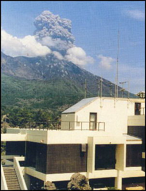
Sakurajima observation center Volcanic activity is rated with five levels; 1 (calm), 2 (slight activity), 3 (small to medium activity), 4 (large activity) and 5 (catastrophic activity). A great amount of resources has been put into predicting eruptions. Scientists were able to predict the Mt. Usu eruption in 2000 and the Miyakejima eruption in 2000 but not the Asama eruption in 2004.
To control mudflows, like the one that killed 23,000 villagers in 1985 in Columbia, the Japanese government has erected steel and concrete silt dams along likely mud flow routes to halt, or a least, slow down their advance so people have enough time to be evacuated. Television cameras and sensitive instruments that take 11 different readings are also used for research and detection.
Scientists in Japan have installed global positioning system (GPS) devices at 30 locations particularly active volcanoes and monitor changes in positions to predict eruptions. The instrument are so sensitive that scientists can gage activity in a magma chamber seven kilometers below the surface. The are mainly looking for swelling on the mountains that occurs before an eruption.
Image Sources: Volcano Research Center University of Tokyo, USGS
Text Sources: New York Times, Washington Post, Los Angeles Times, Daily Yomiuri, Times of London, Japan National Tourist Organization (JNTO), National Geographic, The New Yorker, Time, Newsweek, Reuters, AP, Lonely Planet Guides, Compton’s Encyclopedia and various books and other publications.
Last updated January 2014
