MT. FUJI
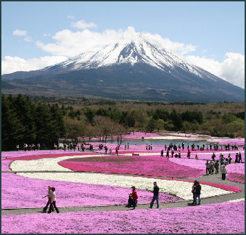
MT. FUJI (65 miles and two hours by bus from Tokyo) is the tallest, most beautiful and revered mountain in Japan. Rising to a height of 12,388 feet, it is also Japan's most well known natural landmark, its most enduring symbol after the rising sun, and an inspiration for generations of poets and artists who have attempted to capture its always-changing beauty which varies with the view, the time of day, the season and the weather.
Encircled by a halo of clouds and topped by streaks of white snow in the summer and early autumn and covered by a full snow cap the remainder of the year, Mt. Fuji is a perfectly-shaped deep -cratered volcano which presides over a plain south of Tokyo and measures about 40 kilometers around at its base. On clear days about a third of Japan's population can see it from near their homes; but most of the time it is shrouded in clouds or haze. Some of the best views of Fuji are from the Hakone area.
In Japan, children grow up singing songs and drawing pictures of Mt. Fuji. The mountain has been featured in many Japanese literary works. Japanese often nickname the best-shaped local mountains by adding the suffix “fuji” to the ancient province name. There are 390 of these regional “Fujis” in Japan.
The Japanese once believed that Mt. Fuji was the center of the universe. It boasts over 13,000 shrines, and each year thousands of mantra-chanting pilgrims with jingling prayer bells, straw hats, pure white robes and white canvas foot mittens ascend to the top of the mountain, stopping at its stations to pray and traversing the rocky peaks around the crater. Buddhists believe they receive merit for climbing it, especially on the 33rd and 88th ascents. Some worshipers leave their sandals on the top of Mt. Fuji to raise its height. Some people have even committed suicide by leaping into the crater with the belief that reach nirvana after their death.
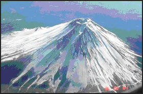
Fujisan, Sacred Place and Source of Artistic Inspiration was declared a UNESCO World Heritage Site in 2013. According to UNESCO: “ The beauty of the solitary, often snow-capped, stratovolcano, known around the world as Mount Fuji, rising above villages and tree-fringed sea and lakes has long been the object of pilgrimages and inspired artists and poets. The inscribed property consists of 25 sites which reflect the essence of Fujisan’s sacred and artistic landscape. In the 12th century, Fujisan became the centre of training for ascetic Buddhism, which included Shinto elements. On the upper 1,500-meter tier of the 3,776m mountain, pilgrim routes and crater shrines have been inscribed alongside sites around the base of the mountain including Sengen-jinja shrines, Oshi lodging houses, and natural volcanic features such as lava tree moulds, lakes, springs and waterfalls, which are revered as sacred. Its representation in Japanese art goes back to the 11th century, but 19th century woodblock prints of views, including those from sand beaches with pine tree groves have made Fujisan an internationally recognized icon of Japan and have had a deep impact on the development of Western art. [Source: UNESCO]
“The serial property consists of the top zone of the mountain, and spread out around its lower slopes shrines, lodging houses and a group of revered natural phenomena consisting of springs, a waterfall lava tree moulds and a pine tree grove on the sand beach, which together form an exceptional testimony to the religious veneration of Fujisan, and encompass enough of its majestic form to reflect the way its beauty as depicted by artists had such a profound influence on the development of Western art.”
See Separate Articles MAJOR VOLCANOES AND ERUPTIONS IN JAPAN factsanddetails.com; VOLCANO COMPONENTS, STRUCTURE AND ACTIVITY factsanddetails.com ; TYPES OF VOLCANOES factsanddetails.com ; VOLCANIC ERUPTIONS: TYPES, PHASES AND CAUSES factsanddetails.com
Websites and Sources on Volcanoes: USGS Volcanoes volcanoes.usgs.gov ; Volcano World volcano.oregonstate.edu ; Volcanoes.com volcanoes.com ; Wikipedia Volcano article Wikipedia , Smithsonian Global Volcanism Program volcano.si.edu operated by the Smithsonian has descriptions of volcanoes around the globe and a catalog of over 8,000 eruptions in the last 10,000 years. Volcano Information in Japan: Volcano Research Center at Tokyo University eri.u-tokyo.ac.jp ; Wikipedia List of Volcanoes in Japan Wikipedia
Websites: Mt. Fuji Climbing fujisan-climb.jp ; JNTO Mount Fuji Guide japan.travel/en; Wikipedia Wikipedia ; Wikitravel Wikitravel ; Sacred Destinations sacred-destinations.com ; Fuji-Hakone-Izu National Park Government National Park Site National Parks of Japan ; Live Fuji live-fuji.jp ; Maps: Mt. Fuji Climbing fujisan-climb.jp ; Climbers.org climber.org Getting There: Lonely Planet Lonely Planet
History of Mt. Fuji
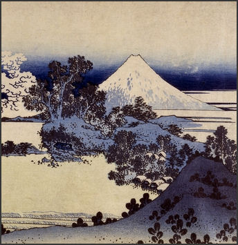
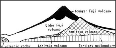
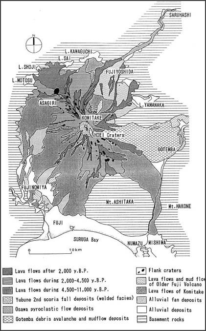
Hokusai view of Fuji The precursor of Mt. Fuji Mt. Komitake volcano was created just north of Mt. Fuji between 200,000 and 700,000 years ago. Old Mt. Fuji erupted with extremely massive explosions about 100,000 years ago and grew out of the south side of Mt. Komitake. New Mt. Fuji emerge from Old Mt. Fuji about 10,000 years ago with eruptions that generated large amounts of lava. The huge lava flows on the flanks of the mountain date to this period.
Today Mt. Fuji is regarded as dormant but still active volcano. It has erupted off and on for the last 2,200 years, with 10 eruptions since A.D. 781 and a large one in 864. Most these eruption spewed large amounts of ash and modest amounts of lava, with eruptions from the summit alternating with eruptions from the slopes. . Eruptions on the slopes occurred on the northwest, northeast and southeast sides.
The last eruption occurred in 1707 between the 5th and 8th station. Smoke and ash were thrust 10,000 meters into the sky and an estimated 850 million cubic meters of stone, sand, and ash was hurled out. Three meters of debris accumulated at the foot of Mt. Fuji and six inches of ash blanketed Tokyo. More fell in the countryside between Mt. Fuji and Tokyo. There were no casualties but hundreds of thousands of people fled the area with wooden buckets over their head. The eruption destroyed crops and farming areas. Famines and social upheaval lasted for 10 years.
A weather station sits on the summit of Mt. Fuji. It is a sprawling complex with radar, monitoring facilities, a device that measures yellow sand, dust and soot carried on winds from China, and dormitories for the scientists and workers who manned the station year round. In 2004 the manned operation st the weather station was closed and replaced with an automated observation system. The observation station for a long was critical for predicting weather but had largely been made obsolete by weather satellites. Keeping the station going was also regarded as too dangerous. Four observers died while on duty The new system needs to be checked only once a year.
Japan lobbied hard to have Mt. Fuji made a UNESCO World Heritage Site. Poems about it appeared in “Manyoshu” ( The Collection of Ten Thousand Leaves ), Japan s oldest collection of poems, and was immortalized in Hokusai woodblock prints “Thirty-six Views of Mt. Fuji”. Fujisan is such a part of the Japanese psyche one university even offers courses in Fuji-ology and members of a religion called Fujiko worship the mountain. Websites: Fuji Volcano eri.u-tokyo.ac.jp ; 1707 Eruption PDF airies.or.jp ; Smithsonian Global Volcanism volcano.si.edu
Mt. Fuji May Be Sitting on an Active Fault
The Yomiuri Shimbun reported: “Mt. Fuji may be sitting on a 30-kilometer active fault capable of generating a magnitude-7 earthquake, which could trigger huge landslides on the mountain, according to a Japanese researcher. If the fault shifts, it could trigger a "sector collapse" on Mt. Fuji, said Prof. Hiroshi Sato, an expert on structural geology at the Earthquake Research Institute of the University of Tokyo. Sato will report the study results at the Japan Geoscience Union Meeting scheduled to start May 20 in Chiba. [Source: Yomiuri Shimbun, May. 12, 2012]
“The active fault is beneath the eastern base of Mt. Fuji near Gotemba, Shizuoka Prefecture. It is thought to be a boundary where the Philippine Sea plate, which lies below the Izu Peninsula, collides with the overriding plate from the south. The active fault connects to the western side of the Kannawa/Kozu-Matsuda fault zone, an area that was previously confirmed, according to Sato.
“As a result of research on an underground structure that simulates ground shaking, the active fault is believed to be about 30 kilometers long from northeast to southwest. It is classified as a reverse fault, which occurs when two rock formations are forced together by compression. The fault becomes deeper as it extends toward Mt. Fuji’s summit, and is believed to be 10 to 20 kilometers deep directly under the mountain’s summit.
“The active fault is thought to have moved within the past 1 million years, but the exact timing and movement cycles are unknown. When a sector collapse occurred at a peak that existed on the eastern slope of Mt. Fuji about 2,900 years ago, it caused an avalanche, launching rocks about 15 kilometers down the mountain and covering an area of current Gotemba and its vicinity. Sato said his team needs to investigate when seismic activity took place at the fault through boring.”
Future Eruption of Mt. Fuji
There are concerns that Mt. Fuji may might erupt violently in the not too distant future. Concerns were raised when a series of low frequency temblors began early 2000 and reoccurred in 2001. These tremors sometimes indicate that magma is starting to rise. Some 15,000 people have participated in emergency drills at the foot of Mt. Fuji.
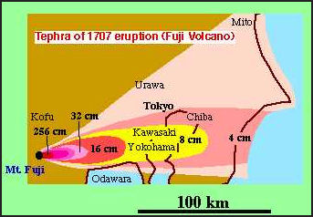
fallout from 1707 Fuji eruption If Mt. Fuji were to erupt like it did in 1707 the damage could be terrible because many more people are living in the area of the mountain than in the 18th century. Such an eruption would produce a huge ash cloud that would blacken the skies over Tokyo and Yokohama. Highways, airports and rail services would be shut down. Lava flows could wipe out large residential areas, block major highways and shut down the railroads. With distribution networks disrupted, food supplies would start to run short and prices sky rocket. If rain falls, soggy ash on transformers could cause short circuits that would cause power failures.
Shizuoka, Yamanashi and Kanagawa prefectures held joint evacuation drills in October 2014 in preparation for the possible eruption of Mt. Fuji. But the joint drills were based on the assumption that an eruption could be predicted. "If Mt. Fuji suddenly erupts," said one of the prefectural government officials in charge of the drills, "how could we inform the tourists? We have to decide on detailed plans, including evacuation routes, as soon as possible." There are concerns that eruptions could paralyse transportation systems. [Source: Yomiuri Shimbun, October 27, 2014]
Plans for a Fuji Eruption
The Japan News reported: “A council studying measures to deal with an eruption of Mount Fuji has compiled wide-scale evacuation plans on the assumption that lava will flow beyond the base of the volcano. The measures were unveiled earlier this month by the panel consisting of officials and experts from Yamanashi, Shizuoka and Kanagawa prefectures. The panel estimates that up to about 130,000 people will be forced to evacuate if the lava flows down to Fuji, a city at the southern foot of the volcano. [Source: The Japan News/Asia News Network, May 19, 2013]
“As a safety precaution, the national government distributed a hazard area map of Mount Fuji in 2004 that showed areas at high risk in the event of a volcanic eruption. Fourteen disaster-related phenomena were assumed to occur, including a pyroclastic flow-or a rapid current of hot gas and rock-volcanic ash and phreatic explosions, which blast steam and rock fragments. Based on the hazard area map, the wide-scale evacuation plans were compiled by the council.
“The plan assumes that craters could appear anywhere around the summit. Since the direction of lava flow is believed to depend on the location of craters and topographical features, evacuation plans were formulated according to 17 different scenarios based on the direction of lava flow. The panel estimated that as many as 750,000 residents in Shizuoka and Yamanashi prefectures would be affected by predicted lava flows.
“Under the evacuation plans, the volcano’s slope from summit to base is classified into five zones according to the likelihood of a crater forming and the elapsed time for lava to reach. Assuming the elapsed time for a lava flow to arrive at within three hours, 24 hours, seven days and 40 days, the plans contain evacuation starting times, meeting places for residents, designated emergency shelters and transportation such as private cars and buses, according to various alert levels.
“For instance, in the event of a level-5 eruption in which lava reaches Fuji, about 130,000 residents will be forced to evacuate. About 700 residents in select areas where a lava flow is predicted to arrive within three hours of eruption will be evacuated to safety by bus and other means. As it is assumed that a huge amount of volcanic ash will be spewed, the panel will also compile an evacuation plan this fiscal year to safeguard against falling ash and mudflow.
Volcanologist Shigeo Aramaki, a member of the council and director of the Yamanashi Institute of Environmental Sciences, said, "This is the first time that such detailed evacuation plans based on various scenarios have been compiled in Japan. "I hope the plans will be implemented to minimise damage from a disaster beyond what we can predict."
Religious Significance of Mt. Fuji
he Japanese once believed that Mt. Fuji was the center of the universe. The female deity of Mt. Fuji, known as Sengen-Sama, holds a high place in the religious hierarchy. Mt. Fuji boasts over 13,000 shrines and each year thousands of mantra-chanting pilgrims with jingling prayers bells straw hats, pure white robes and white canvas mittens on their feet ascend to the top of the mountain, stopping at its stations and traversing the rocky peaks around the carter. Some worshipers leave their sandals on the top of Mt. Fuji to raise its height.
According to an ancient folktale Mount Haku, another sacred mountain also known as Yatsu-ga-take, was once higher than Mt. Fuji. "Once the female deity of Fuji and the male deity of Haku (Gongen-sama) had a contest to see which was higher," the myth goes. "They asked the Buddha Amida to decide which was loftier. It was a difficult task. Amida ran a water pipe from the summit of Yatsu-ga-take to the summit of Fuji-san and poured water in the pipe. The water flowed to Fuji-san, so Amida decided that Fuji-san was defeated. Although Fuji-san was a woman, she was too proud to recognize her defeat. She beat the summit of Yatsu-ga-take with a big stick, so his head was split into eight parts, and that is why Yatsu-ga-take (Eight Peaks) now has eight peaks."
According to UNESCO: “From ancient times, pilgrims carrying a long staff, set off from the compounds of the Sengenjinja shrines at the foot of the mountain to reach the crater at its summit where it was believed that the Shinto deity, Asama no Okami resided. At the summit, they carried out a practice called ohachimeguri (literally, “going around the bowl”), processing around the crater wall. There were two types of pilgrims, those who were led by mountain ascetics, and from the 17th century onwards, those in greater numbers who belonged to Fuji-ko societies that flourished in the prosperous and stable Edo period. [Source: UNESCO]
“As pilgrimages became more popular from the 18th century onwards, organizations were established to support the pilgrims’ needs and routes up the mountain were delineated, huts provided, and shrines and Buddhist facilities built. Curious natural volcanic features at the foot of the mountain, created by lava flowing down after volcanic eruptions, came to be revered as sacred sites, while the lakes and springs were used by pilgrims for cold ablutions, Mizugori, to purify their bodies prior to climbing the mountain. The practice of making a circuit of eight lakes, Hakkaimeguri-including the five lakes included in the Fujigoko (Fuji Five Lakes)-became a ritual among many Fuji-ko adherents. Pilgrims progressed up the mountain through what they recognised as three zones; the grass area around the base, above that the forest area and beyond that the burnt or bald mountain of its summit.
Mt. Fuji: UNESCO World Heritage Site
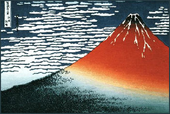
Hokusai view of Fuji Fujisan, Sacred Place and Source of Artistic Inspiration was declared a UNESCO World Heritage Site in 2013. After the mountains was inscribed, Kyodo reported: “Japan’s highest and most celebrated peak was designated a “cultural” rather than “natural” site and registered under the title “Mt. Fuji: Object of Worship, Wellspring of Art.” Japan asked UNESCO to register Mount Fuji in January 2012 because it has been viewed as a religious site, depicted in ukiyo-e paintings and helped nurture Japan’s unique culture. Fuji spans roughly 70,000 hectares, including Sengen Shrine at its foot, five major lakes, the Shiraito Falls and the Miho-no-Matsubara pine grove. [Source: Kyodo, June 23, 2013]
According to the Yomiuri Shimbun: The Mt. Fuji UNESCO World Heritage Site” comprises 25 cultural and natural properties, including lakes and shrines. The site’s main properties are located in the region of the mountain 1,500 meters and higher above sea level. They include the various objects of veneration on the summit, its four trails such as the Yoshidaguchi and Subashiriguchi routes, Lake Motosu and Lake Sai. The registered site also covers Fujisan Hongu Sengen Taisha, the head shrine of Sengen Shrine, in Fujinomiya, Shizuoka Prefecture, and two Oshi overnight lodges for climbers in Fuji-Yoshida, Yamanashi Prefecture. [Source: Yomiuri Shimbun, June 24, 2013]
“Such climbers were devotees of Fujiko groups — religious associations based on the worship of Mt. Fuji — which prospered when they became popular among the masses in the Edo period (1603-1867) . Hasegawa Kakugyo, the founder of Fujiko, is said to have conducted ascetic training in a lava cave on the grounds of Fujinomiya’s Hitoana Fujiko Iseki, which is one of the 25 properties. Other highlights of Japan’s newest World Heritage site include such natural assets as the Shiraito no Taki waterfall, also in Fujinomiya, and Oshino Hakkai in Oshino, Yamanashi Prefecture, eight sacred springs below the 1,500-meter level of the mountain.”
Sacred and Artist-Inspiring Mt. Fuji
According to UNESCO: “The solitary, often snow-capped Mount Fuji (Fujisan), rising above villages and tree-fringed sea and lakes, has inspired artists and poets and been the object of pilgrimage for centuries. Fujisan is a solitary strato-volcano, around 100 kilometers south-west of Tokyo that rises to 3,776 meters in height. The base of its southern slopes extends to the sea shores of Suruga Bay.
“The awe that Fujisan’s majestic form and intermittent volcanic activity has inspired was transformed into religious practices that linked Shintoism and Buddhism, people and nature, and symbolic death and re-birth, with worship ascents and descents to and from the summit, formalised in routes and around shrines and lodging houses at the foot of the mountain. And the almost perfect, snow-capped conical form of Fujisan inspired artists in the early 19th century to produce images that transcended cultures, allowed the mountain to be known around the world, and had a profound influence on the development of Western art.
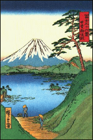
Hokusai view of Fuji ”From the 14th century, artists created large numbers of images of Fujisan and between the 17th to the 19th century, its form became a key motif not only in paintings but also in literature, gardens, and other crafts. In particular the wood block prints of Katsushika Hokusai, such as the Thirty-Six Views of Mount Fuji, had a profound impact on Western art in the 19th century and allowed the form of Fujisan to become widely known as the symbol of ‘Oriental’ Japan.
“The majestic form of Fujisan as a solitary strato-volcano, coupled with its intermittent volcanic activity, has inspired a tradition of mountain worship from ancient times to the present day. Through worship-ascents of its peaks and pilgrimages to sacred sites around its lower slopes, pilgrims aspired to be imbued with the spiritual powers possessed by the gods and buddhas believed to reside there. These religious associations were linked to a deep adoration of Fujisan that inspired countless works of art depicting what was seen as its perfect form, gratitude for its bounty, and a tradition that emphasised co-existence with the natural environment. The series of sites are an exceptional testimony to a living cultural tradition centred on the veneration of Fujisan and its almost perfect form.
“Images of Fujisan as a solitary strato-volcano, rising above lakes and sea, have been a font of inspiration for poetry, prose and works of art since ancient times. In particular the images of Fujisan in early 19th-century Ukiyo-e prints by Katsushika Hokusai and Utagawa Hiroshige had an outstanding impact on the development of Western art, and have allowed the majestic form of Fujisan, which can still be appreciated, to be known around the world.”
Pilgrims on Mt. Fuji
Daisuke Tomita wrote in the Yomiuri Shimbun: “In early June, people dressed in white religious garb gathered at a shrine located at the northern foot of Mt. Fuji. They are ascetic devotees belonging to one of Fujiko groups—religious associations that worship Mt. Fuji. In front of them was a bonfire, and the devotees began putting boards, called saiboku, into the fire one after another. On the saiboku, people’s wishes for good health and business success were written. It was a holy ritual to relay people’s wishes to the god of the mountain. The saiboku burned instantly and smoke soared into the sky. [Source: Daisuke Tomita. Yomiuri Shimbun: June 28, 2013]
“Then a man facing the bonfire began chanting the mantras of his Fujiko group. Hot air blew toward him, but Yoshitsugu Saito continued his sonorous chants. Saito, 82, joined the group about 60 years ago after being seriously injured in an accident. Since then, he has undertaken various ascetic practices and maintained a clean-living lifestyle, which is a tenet of Fujiko associations. He has visited Mt. Fuji numerous times from his home in Kanagawa Prefecture, and he has climbed the mountain — from the base to the summit — nearly 50 times.
“Mt. Fuji has been recognized for its cultural value as a holy mountain worshiped by people since ancient times. Its constituent property includes the five lakes around its base and the surrounding shrines, caves and trails. One day, Emiko Ozawa sent off ascetic devotees from her lodge near Mt. Fuji. Ozawa, 68, gracefully knelt at the entrance and placed her hands on the floor. “We wish you a safe journey,” she said. The Zuzuya lodge has a history of more than 400 years. The lodge is one of the “Oshi-no Ie” lodges, where ascetic devotees learn the principles of Fujiko and receive instruction on safe climbing. The lodge also serves food to visitors.
“During the Edo period (1603-1867), the current Fuji-Yoshida area was flooded with ascetic devotees and there were more than 80 such lodges. However, only a handful of them remain today. Ozawa’s son and the 20th generation master of Zuzuya, Terunobu, 38, said: “I’m resolved to maintain the culture [of Oshi-no Ie] as long as ascetic devotees visit our lodge.”
“I had an opportunity to enter Yoshida Tainai Jukei, a cave created by a large eruption of Mt. Fuji in 864. It was a narrow and damp cave that I could only enter by crouching. The cave is known as a sacred place and carefully protected by local residents. There is a small shrine at the back of the cave and in the past, ascetic devotees entered the cave to “purify” themselves before climbing Mt. Fuji.”

cross section of Fuji
Image Sources: 1) 7) 17) JNTO 2) 3) 6) British Museum 4) 5) 14) Volcano Researach Center University of Tokyo 8) 12) Andrew Gray Photosensibility 9) Yamanashi Tourist Information 10) 13) Mount Fuji Guide 11) Climber.org 15) 19) 20) Kanagawa Tourist information 16) 18) Visualizing Culture, MIT Education 21) Wikipedia
Text Sources: JNTO (Japan National Tourist Organization), Japan.org, Japan News, Japan Times, Yomiuri Shimbun, UNESCO, Lonely Planet guides, New York Times, Washington Post, Los Angeles Times, National Geographic, The New Yorker, Bloomberg, Reuters, Associated Press, AFP, Compton's Encyclopedia and various books and other publications.
Updated in July 2020
