TAMBORA

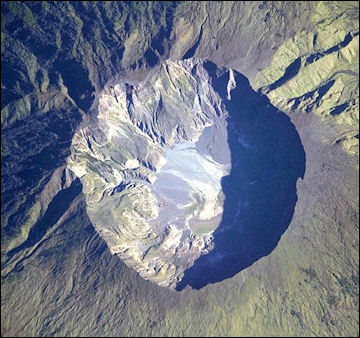
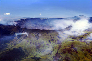
TamboraTambora (northern Sumbawa) is the volcano that erupted spectacularly in 1815 with five times the force of Krakatau. Reaching a height of 2,851 meters, Tambora is the tallest peak in Indonesia outside of Papua and has been mostly dormant since 1815. You can hike to the rim of the crater and peer over the edge into the crater’s remarkable gigantic hole that has a diameter of over six kilometers wide. In the crater are two colored lakes. The slopes of the volcano contain house-size boulders and grasses burned by hunters not the eruption. The inside of the crater is barren and the floor is brown, flat and dry. Sometimes a lake is produced here in the rainy season. In the air you can smell sulfur. The local name for the mountain is “gone.”
Tambora is situated near the northern edge of the island of Sumbawa in the West Nusa Tenggara Province, between the islands of Lombok and Flores. It can be reached in a few hours from Bima by a very bumpy bemo or bus ride. A road climbs up about a third of the way to the summit on the southern slope. From here you can take a trail that switches back and forth to the summit. After several hours you reach the 1000-meter-deep crater. Not many people do the climb because the road to get to the trail is very poor and the bus ride is long and bumpy.
Mount Tambora is known to the world as the site of the largest and most deadly volcanic eruption in recorded history. Just like Mount Toba in North Sumatra, it is recognized as one of the world’s supervolcanoes. However, while Mount Toba hasn’t been active in tens of thousands of years, Mount Tambora is still regarded as active.
The mega-eruption of Mount Tambora plunged the Earth into a multi-year period “volcanic winter.” It left a a seven-kilometers-by-6.2 kilometers wide crater containing a two-colored lake with depths reaching 800 meters, considered as the largest crater lake in Indonesia after Lake Toba. In 2004, archaeologist Haraldur Sigurdsson discovered the preserved bodies of two adults buried in nearly 10 feet of ash in the remnants of a small village on the volcano.
Book:“Tambora: The Eruption that Changed the World” by Gillen D’Arcy Wood, 2014]
See Separate Articles VOLCANOES IN INDONESIA factsanddetails.com ; KRAKATOA ERUPTION AND TRAVELING TO ANAK KRAKATAU factsanddetails.com ; VOLCANO COMPONENTS, STRUCTURE AND ACTIVITY factsanddetails.com ; TYPES OF VOLCANOES factsanddetails.com ; VOLCANIC ERUPTIONS: TYPES, PHASES AND CAUSES factsanddetails.com ; DESTRUCTIVE ERUPTIONS: LAHARS, PYROCLASTIC FLOWS AND GLACIAL BURSTS factsanddetails.com
Websites and Sources on Volcanoes: USGS Volcanoes volcanoes.usgs.gov ; Volcano World volcano.oregonstate.edu ; Volcanoes.com volcanoes.com ; Wikipedia Volcano article Wikipedia , Smithsonian Global Volcanism Program volcano.si.edu operated by the Smithsonian has descriptions of volcanoes around the globe and a catalog of over 8,000 eruptions in the last 10,000 years.
Tambora Eruption

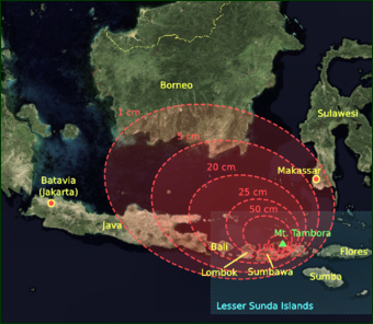
Tambora Caldera The deadliest volcanic eruption in the last 10,000 years occurred on Tambora on Sumbawa, an island east of Bali in Indonesia. It killed 92,000 people in April 1815. Twelve thousand died in the blast; the remainder died in tsunamis or starved to death because their crops and livestock were destroyed, mostly on Sumbawa and Lombok. [Source: Robert Evans, Smithsonian Magazine, July 2002]
Tambora came to life on April 5, 1815 after lying dormant for thousands of years. It produced an explosion that was so loud soldiers hundred of miles away in Java, thinking they had heard cannon fire, suited up for battle. A few days later came the climactic explosions. Three columns of fire shot up from the mountain and a plume of smoke and gas reached 25 miles into the atmosphere. The eruptions ended in July.
The Tambora blast was ten times more powerful than the Krakatau explosion (see Below). It darkened the sky at noon and produced energy equivalent to all the nuclear bombs in the world. Between 26 and 43 cubic miles of material was discharged (a recorded world record), around 12 cubic miles of gases, dust and rock was blasted into the atmosphere.
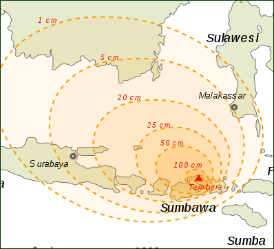
The explosions created a five-mile-wide crater and reduced the elevation of the mountain from 13,450 feet to 9,350 feet. Pyroclastic flows roared down the slopes at 100 miles an hour and incinerated grasslands and forests and everything else in their path. Fire-generated winds uprooted trees. Huge floating rafts of pumice trapped ships in their harbors. Ash rained down for weeks on areas hundreds of miles from the volcano. The roofs of houses collapsed. Freshwater sources were contaminated and crops and plants died.
Effects of the Tambora Eruption
Tambora’ss explosion created the huge quantities of sulfurous gas which mixed with water in the air, producing a cloud of sulferic acid, ash and dust that was blown around the world by stratospheric winds. Ice cores taken from Greenland in 1815 and 1816 show unusually high levels of sulfur, a remnant of the Tambora explosion.
In “Tambora: The Eruption that Changed the World,” Gillen D’Arcy Wood describes how Tambora consumed whole villages in “a vortical hell of flames, ash, boiling magma and hurricane-strength winds.” The blast was six times more powerful than the eruption at Mount Pinatubo in 1991 and it dwarfed the one that destroyed Pompeii. Haraldur Sigurdsson, a volcanologist from the University of Rhode Island, told The Guardian: "We know that in an eruption such as that in 1815, that pyroclastic flows extend from the volcano in all directions to a distance of at least 40 kilometers [24 miles] radially and within that zone ... there is an extinction of all life."

1815 Tambora explosion Gillen D’Arcy Wood, author of “Tambora: The Eruption that Changed the World”, wrote: “Crops failed from Indonesia to Ireland, and millions of desperate refugees poured into the cities. Famine-friendly diseases, typhus and cholera, spread like wildfire. In an ultimate measure of desperation, some parents killed their own children out of mercy (tales of post-Tambora filicide are told from Bali to China to Switzerland). Even in the United States, where a much-feared famine was largely averted, thousands of people fled the Tambora weather of freezing New England for the promised land of the frontier. Within a few short years a half-dozen states of the modern Midwest had been founded. [Source: Gillen D’Arcy Wood, Bloomberg commentary, November 2013]
Ian Sample wrote in The Guardian, “Mount Tambora's eruption on April 10 1815 smothered villages on the island of Sumbawa with pumice, ash and rock, and claimed the lives of 90,000 people. The impact of the blast was felt around the world. The volcano ejected more than 30 cubic kilometres of magma and thrust nearly 400m tonnes of sulphur dioxide into the atmosphere, which caused a global cooling of nearly 1C, creating what volcanologists refer to as the "year without a summer". Debris and ash from the eruption brought destruction to crops as far afield as North America, France and Germany. In Britain, fine particles suspended in the atmosphere created rich, vibrant skies for more than a year. [Source: Ian Sample, The Guardian, March 1, 2006]
Major Volcanic Eruptions
Worst Recorded Volcanic Eruptions (number of dead): 1) Mt, Tambora, Sumbawa, Indonesia, Apr. 10-12, 1815 (92,000); 2) Krakatoa, Indonesia, Aug. 26-28, 1883 (36,000); 3) Mt. Pelée, Martinique, May 8, 1902 (28,000); 4) Nevado del Ruíz, Columbia, Nov. 13, 1985 (23,000); 5) Mt. Vesuvius, Italy, Aug 24, 79 AD (16,000); 6) Mt. Unzen, Japan, May 21, 1792 (14,500); 7) Kelud, Java, Indonesia, 1586 (10,000); 8) Laki, Iceland, June 8, 1783 (9,350); 9) Mt. Kelud, Java, Indonesia, May 19, 1919 (5,000); 10) Mt. Vesuvius, Italy, Dec. 15, 1631 (4,000); 11) Mt. Papandayan, Java, Indonesia, Aug. 12, 1772 (3,000); 12) Mt. Lamington, New Guinea, Jan 17-21, 1951, New Guinea (3,000); 13) El Chichon, Mexico, May 28, 1982 (1,800); 14) Lake Nyos, Cameroon, Aug. 21. 1986 (1,700); 15) Mt. Taal, Philippines, Jan 30. 1911; 16) Santa Maria, Guatemala, Apr. 24, 1902 (1,000); 17) Mt. Pinatubo, Luzon, Philippines, June 15, 1991 (800); 18) Mt. St. Helens, May 18, 1980 (57).
Volcanologists rank large eruptions as: Level 5) like the ones at Mount St. Helens in 1980 and Mt. Vesuvius in the A.D. 1st century that occur every 10 years and release less than a hundred cubic kilometers of material; Level 6) like the ones at Mount Pinatubo in 1991 and Krakatau in 1883 that occur every 100 years and release more than a hundred cubic kilometers of material; Level 7) like the one at Tambora in Indonesia in 1815 that occur every 1,000 years and release more than a 1,000 cubic kilometers of material; and Level 8) like the ones at Toba 750,000 years ago and Yellowstone 2.1 million years ago that occur every 50,000 to 100,000 and release 2,500 to 3,000 cubic kilometers of material. The largest volcanic event known is an eruption in Colorado 28 million years ago that released more than 5,000 cubic kilometers of material. A Level 8 is regarded as a supervolcano. The threat posed by a supervolcano is regarded as worse and ten times more likely to happen than an asteroid impact. If one were to occur today it could kill millions with the initial eruption and kill perhaps billions if a natural “nuclear winter” were triggered.
Village Buried by Tamboro Reveals Clues of How People Died

Tambora ashfall in 1815
In 2006, Ian Sample wrote in The Guardian, “Archaeologists have uncovered remains of an Indonesian civilisation entombed by debris from the largest volcanic eruption in modern history.
With the help of a local guide, scientists working on the island have unearthed the village of Tambora. Among sediments that date back to the eruption, they discovered ceramic pots, bronze bowls and the carbonised remains of a house with two occupants inside. [Source: Ian Sample, The Guardian, March 1, 2006]
“Inside, a woman was found in the kitchen, her hand next to some molten glass bottles. The house, which stood on on wooden stilts with bamboo sides and a thatched roof, had been incinerated into charcoal by the fiery ash that is believed to have reached more than 500 degrees C. The remains of a second person were found outside what was probably the building's front door. Haraldur Sigurdsson, a volcanologist from the University of Rhode Island who is leading the dig, said the entire village, its occupants and culture were encapsulated beneath the ash, making the finding of great cultural significance. [Source: Ian Sample, The Guardian, March 1, 2006]
The remains reveal how the village's 10,000 residents were probably wiped out within moments as the avalanche of hot volcanic ash, rock and gases, known as a pyroclastic flow, struck. The civilisation on Sumbawa island has intrigued researchers ever since Dutch and British explorers visited in the early 1800s and were surprised to hear a language that did not sound like any other spoken in Indonesia, Prof Sigurdsson said. Some scholars believe the language was more like those spoken in Indochina. But not long after westerners first encountered Tambora, the society was destroyed.
"The explosion wiped out the language. That's how big it was," Prof Sigurdsson said. "But we're trying to get these people to speak again, by digging." Artefacts uncovered at the site suggest that Tambora people may have had trade links with Indochina. Pottery uncovered nearby resembles that commonly found in Vietnam. The dig will help volcanologists predict the potential dangers of volcanoes which remain active today. By feeding details from Tambora into computer models, they can estimate the lethal reach of those volcanoes should they erupt. "Events of this type will occur in the future, and we should be aware of what could happen," said Prof Sigurdsson.
Crazy Weather After Tamboro
So much material was in this cloud that it lowered temperatures around the globe and produced blizzards in the Midwest and snowfall in the U.S. east coast and London in August, caused poor harvests in New England and Europe, and killed water buffalo and flooded rice crops in China and Tibet in what became known as the year without summer. One Virginia resident wrote. “In June...another snowfall came and folks went sleighing...On July 4, water froze in cisterns and snow fell again, with Independence Day celebrants moving inside churches where hearth fires warmed things a mite.” Among other things the volcano is believed to have produced the appalling weather that disrupted Napoleon at Waterloo and caused crop failures and famines that lead to social unrest throughout Europe. The gloomy weather inspired Byron’s poem “Darkness” and is believed to have had a hand in creating the characters Dr. Frankenstein and the monster by Bryon’s friend Mary Shelley.
Nancy Szokan wrote in the Washington Post, “In June 1816, the weather along the Atlantic seaboard went crazy. The sky over North Carolina turned black with hailstones. Boston baked in 90-degree temperatures — soon followed by a freeze and a storm that dropped a foot of snow across the Northeast. Further frosts were recorded in July and August. Crops that weren’t killed by the cold died in that summer’s brutal drought. Similarly extreme weather conditions around the world from 1815 to 1818 led to widespread famine, the shrinking of polar ice, a global pandemic of cholera and the growth of China’s opium trade. [Source: Nancy Szokan, Washington Post, May 5, 2014]
Climbing Tamboro and Wildlife There
Today, aside from attracting seismologists, volcanologists, archeologists, biologists, and other scientists, Mount Tambora is also known as a destination for mountaineers and hikers, There are two ascent routes to reach the caldera. The first route, the Doro Ncanga starts from Doro Mboha Village southeast of the mountain. This route follows a paved road through a cashew plantation until it reaches 1,150 meters (3,770 ft) above sea level. The end of this route is the southern part of the caldera at 1,950 meters (6,400 ft), reachable by a hiking track. This location is usually used as a base camp to monitor the volcanic activity because it only takes one hour to reach the caldera. The second route starts from Pancasila village northwest of the mountain, known as the Doro Peti is steep. Using the second route, the caldera is accessible only on foot. The climb to the caldera usually takes two days through dense forests.
The marvels of Mount Tambora also lie in the two conservation areas situated at the foot of the mountain. The first is the 18,178.66 hectares Mount Tambora South Wildlife Reserve (Suaka Margasatwa Gunung Tambora Selatan) that offers hilly and mountainous landscapes and steep valleys. Among some of the animals that dwell here are: Wild Boars (Sus scrova scrova), Timorese Deer (Cervus timorensis), White Parrots (Cacatua galarita), Red Chest Perkici (Tricoglosus haematodus mitchelli), and Yellow crowned Parrots (Cacatua sulphurea).Visitors can observe the traditional process of collecting natural honey. The second is the South Tambora Hunting Park situated south of the Wildlife Reserve. As the name suggests, the site is a perfect place for those who wish to conduct hunting safaris. Here, there are a great number of deer and wild boar running freely, making it an exciting place to hunt.
Accommodation and Getting to Mount Tambora
The accommodation options on and around Mount Tambora itself is obviously limited to tents and camping at the camping grounds or along the mountain track. The nearest town which can offer accommodation and other facilities is the town of Bima. Here are some of the hotels and inns you can find in Bima: 1) Lambitu Hotel, Sumbawa Street 19, Bima, Tel. (0374) 42222; 2) Parewa Hotel, Sukarno Hatta Street, Bima, Tel. (0374) 42536; 3) Lila Graha Hotel, Lombok Street 20, Bima, Tel. (0374) 42740; 4) Komodo Wisma, Sultan Ibrahim Street 5, Bima, Tel. (0374) 42070; 5) Anggrek Losmen, Tente Street, Bima, Tel. (0374) 81084; 6) Kartini Losmen, Sultan Hasanudin Street, Bima, Tel. (0374) 42072; 7) Putra Sari Losmen, Sukarno Hatta Street, Bima, Tel. (0374) 42870
You can fly to Sumbawa Besar and Bima from Bali (occasionally), from where tours can be arranged to Gunung Tambora. Fights also fly in from Mataram on Lombok in under an hour. Boats serve Port Tano from east Lombok, from where buses take about 5 or 6 hours to reach Dompu, the stop-off point.
To reach Mount Tambora, first you need to get to the village of Pancasila. It is problematic if you want to do this in one day from Sumbawa Besar. If you want to try, take the Sumbawa Besar/Dompu bus very early in the morning and tell the driver you want to go to Calabai/Pancasila. You can try saying in Indonesia: Mau mendaki Tambora (I want to climb Tambora). He will drop you after four to five hours at the tee-intersection from where the road to the right goes to Dompu (about 20 kilometers away) and the road to the left takes you to Calabai. There are regular buses to Calabai but the road is a bit bumpy and the 110 kilometers trip takes 4-5 hours. From Calabai you have to take an ojek (back of a motorcycle) to Pancasila.
It may be wiser and less taxing to go to Dompu, have a good night's rest and make the journey to Calabai/Pancasila the next day. In that way you will arrive in Pancasila reasonably rested. Buy supplies for the trip in Calabai. There are plenty of shops selling noodles, biscuits, fruit, bottled water etc.If you are riding a motorbike/scooter be warned: the road is really pot-holed and you must pay it the respect it's due. Allow six hours for the 130 kilometers Dompu — Pancasila journey.
RELATED ARTICLE: SUMBAWA: SIGHTS, BEACHES, TAMBORA factsanddetails.com
Image Sources: Wikimedia Commons
Text Sources: Indonesia Tourism website ( indonesia.travel ), Indonesia government websites, UNESCO, Wikipedia, Lonely Planet guides, New York Times, Washington Post, Los Angeles Times, National Geographic, The New Yorker, Bloomberg, Reuters, Associated Press, AFP, Japan News, Yomiuri Shimbun, Compton's Encyclopedia and various books and other publications.
Last updated in January 2024
