WEST SUMATRA
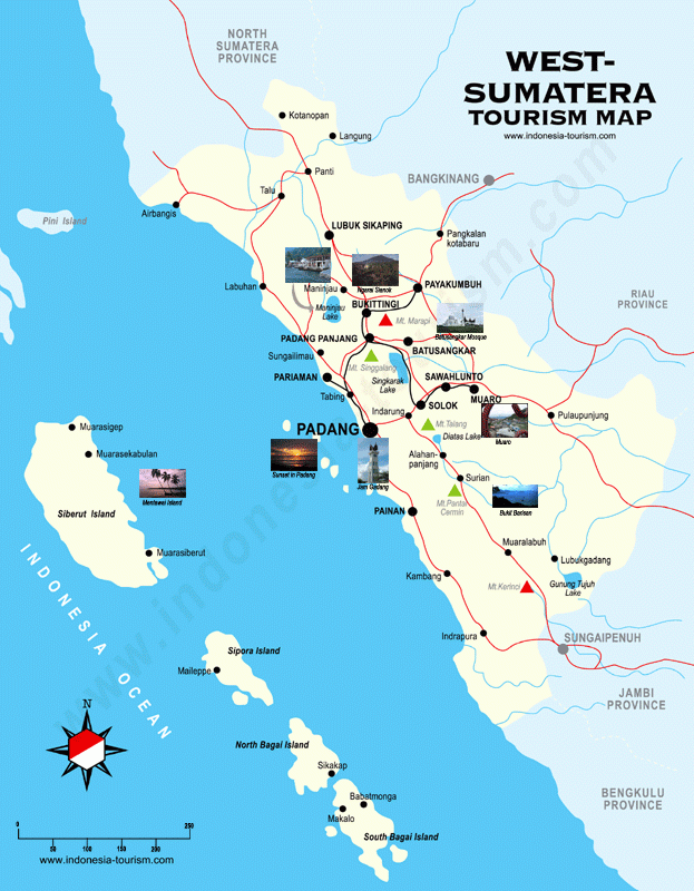
West Sumatra is very wild and very rugged. Much of it resembles a nature reserve. There are high mountains, jungle-coverd volcanos. rain forests and lakes in the hinterlands and coconut groves and houses with horn-shaped roofs in the populated areas. West Sumatra is dominated by the Padang Highlands, which contains some peaks over 3,000 meters and several active volcanos. Mountain lakes provide irrigation water for wet rice farming in the flat areas of the highlands. West Sumatra is the traditional homeland of the Minangkaban. They make of 95 percent of the province’s population
Much of its highland is formed by the Bukit Barisan Mountain range; virgin jungles inhabited by elephants, tigers, leopards and rhinos. The Minang people enjoy spicy-hot dishes and follow ancient matriarchal customs. The women own property and the men leave home to seek their fame and fortune. Traveling is considered a mark of success, Padang restaurants are found in all major towns across the nation. The people are hospitable and eloquent. They primarily speak Bahasa Minang, with poetic style of speech.
West Sumatra days are filled with colorful ceremonies and festivals. According to one legend the Minangkabau are descendants of King Maharjo Dirajo, said to be the youngest son of Alexander the Great. During the early 19th century, the area was disrupted by wars between the followers of the traditional Islam or Padris, and those adhering to the traditional law (adat) of the Minangkabau.
West Sumatran dishes tend to be spicy. Specialties include dendeng (a kind of beef jerky made with coconut water), kampiun porridge and black sticky rice Fresh fruit, especially marquisa or passion fruit are abundant, affordable, and very are sweet. Bilih fish from Lake Singkarak have a unique and delicious taste. It is served in variety of ways including fried, flavored with chili, or boiled. Beef Rendang is cubed beef has been marinated and cooked in many kinds of ingredients, resulting in the soft unforgettable meat dish which tastes heavenly eaten with steaming hot rice. Rendang balado is the same dish made with dried beef. Another spicy favorite dessert is the Pisang kapik, or the barbequed banana, that comes in sweet, sour or salty tastes added with ground coconut meat and brown sugar. Other tidbits to take home or munch on the road are the many kinds of crackers made of casssava, potatoes or sweet potatoes, covered in cheese or chilli sauce.
Getting There : Padang's Tabing Airport is the main gateway to West Sumatra and is serviced by Merpati Nusantara Airlines. PELNI's ship "Kerinci" sails every two weeks for Jakarta from Teluk Bayur Harbour. Smaller vessels from Muara Harbour sail to small towns along the entire west coast of Sumtra. Regular bus services run between Padang, Bukittinggi and other major cities of Sumatra, as well as via the trans-Sumatra Highway to Jakarta. Tourism Office West Sumatra : Jl. Khatib Sulaiman 7 Padang, Phone. (62-751) 7055711, 446282, Fax. 7055183, Mentawai Island : Jl. Raya Tuapejat kilometers 4, Phone. (62-759) 320042. minangkabautourism.info
Minangkabau
The Minangkabau live in West Sumatra. Also known as the Menangkabau or the Minang for short, they are a Muslim people and regarded as culturally similar to their neighbors, the Malays, except that they mark descent through the female line and are really into water buffalo. They are also known as being hospitable and clever, and celebrate colorful festivals. Minangkabau means “water buffalo victory.” [Source: Encyclopedia of World Cultures, East and Southeast Asia edited by Paul Hockings (G.K. Hall & Company, 1993) ~]
The Minangkabau are the largest matrilineal culture in the world and the fourth largest ethnic group in Indonesia. Tribe, clan (or suku) titles, properties and names are all handed down through the female line. The grandmother is the ultimate matriarch and a power figure. Although the Minangkabau are Muslim, their customs are unique and unusual in a state with a predominantly Muslim culture. Most such matriarchal customs are justified by tradition, although they are sometimes supported by examples from the sira of the Prophet Muhammad, especially stories revolving around the centrality of Muhammad's first employer and subsequent wife, Khadija. [Source: Wikipedia]
RELATED ARTICLES:
MINANGKABAU PEOPLE: HISTORY, RELIGION, CHARACTERISTICS factsanddetails.com
MINANGKABAU: THE WORLD’S LARGEST MATRIARCHAL SOCIETY factsanddetails.com
MINANGKABAU LIFE AND CULTURE: HOUSES, FOOD, CRAFTS, SPORTS factsanddetails.com
BUKITTINGGI AREA OF WEST SUMATRA: MINANGKABAU AND WORLD'S LARGEST FLOWER factsanddetails.com
ETHNIC GROUPS IN SUMATRA factsanddetails.com
SUMATRA: HISTORY, EARLY HUMANS, GEOGRAPHY, CLIMATE factsanddetails.com
Padang
Padang (21 hours by bus from Medan, at the western extreme of Sumatra) is the capital of West Sumatra and is home to around 830,000 people. It sprawls over a large area and is hot and hunid and often rainy. Padang means “flat.” Padang is home to an old town and a university. Worth seeing are the Padang museum and Bungus Bay which has a beach where one can watch the fishing boats pass by. Small boats can be hired at Bungas Bay to visit the smaller islands offshore. There are dozens of food stalls in Taman Ria Pantai Padang at the southern end of Jl. Samudera.
Padang is the gateway to the Minang highlands. With the largest port on Sumatra’s West Coast, this is a merchant town attracting ships trading in goods such as rubber, cinnamon, coffee, tee, cement and coal. If you take a stroll down to the old colonial waterfront you’ll see century old warehouses stocked with fragrant cinnamon and other spices waiting to be shipped to Jakarta and Singapore. The Batang Arau River flows through the city and it is quite a sight to see the collection of small boats and hand paddled ferries that line the riverside. You can do some scuba diving activities in the Padang area.
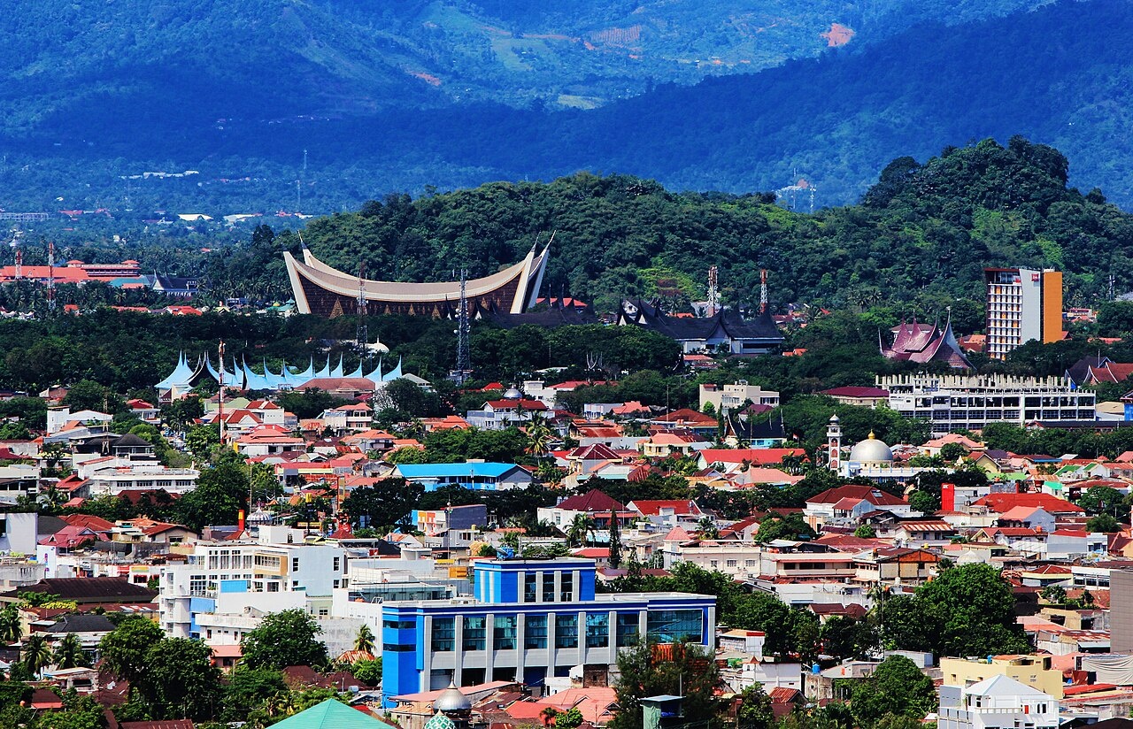
While you in Padang Take a pleasant walk around the older parts of Padang like Kampung Cina (China town) where turn-of the-century houses line the streets. Around here you’ll see a collection of Chinese herbalists doing business as well as coffee shops that can provide a refreshing cool drink to escape the heat of the day. The Provinicial Museum in downtown Padang is home to a collection of prehistoric artifacts, stamps, imported ceramics, modern art and displays about the Minang and Mentawai culture.
Padang is a major link between Sumatra and the rest of Indonesia. Many travelers finish their trip in Sumatra here and either fly home or on to Java. Flights can be taken to destinations all over the country and there is a fortnightly passenger ship to Jakarta which takes 30 hours. There is plenty of great scenery south of Padang. On the way to Bukittinggo there are lovely Minangkabau villages with traditional houses set among terraced rice fields.
Hotels, Restaurants and Transport in Padang
There is a range of accommodation options in Padang from budget losmen to delux ehotels. The Buminang Hotel is a four star establishment, fully equipped with karaoke rooms. The Inna Muara Hotel is a mid range centrally located hotel with rooms with air conditioning.
Most attractions in Padang are within walking distance but if you need a break, there are metered taxis available. The city is also serviced by mini buses and buses. For A slower, more romantic option try a bendi — a horse drawn cart.
Padang is half-way up Sumatra’s west coast and is served by a good network of land, air and sea routes. Padang’s new airport is the Bandara Internasional Minangkabau (off Jl Adinegoro), 20 kilometers north of the center of town. Domestic flights go daily between Padang and Jakarta, Medan and Palembang. Airlines operating flights to Padang include Garuda, Air Asia and Lion Air. Padang’s Bengkuang bus terminal is located 12 kilometers from town.
If you like a little spice in your food then Padang is the place for you. Famous throughout Indonesia for its distinctive cuisine, Padang is the place to go to sample the famous spicy nasi padang food that has spread throughout the country and the world. Padang food includes such delicacies as the spicy coconut curry rendang and soto padang. Experience the unique way Padang food is served. Watch how waiters expertly carry more than ten plates with all kinds of delicacies on both arms. These dishes will then be spread out on the table for diners to pick and choose. You will be charged only for those dishes you have tasted.
Beaches Near Air Manis
Air Manis (15 kilometers from Padang city center) is Padang’s most popular beach. Located about one hours walk along the coast (or a quick trip in a minibus) from the edge of Padang, this beach is a favorite for locals and tourists because it has low waves and beautiful views of Mount Padang. Near the beach, there are restaurants selling grilled fish, Kapau rice and other snacks. There is also a small island called Pisang Kecil (literally means “small banana” ) on its right side. At low tide you can walk to this one hectare island through shallow water. During high tide you have to take a boat. On its right, there is another island called Pisang Besar (literally means “big banana” ). Local inhabitants on this island are mostly farmers and fishermen.
The legend of Air Manis says that once a young man named Malin Kundang went out to sea to become a rich merchant. When he returned home, his mother was so excited she dressed in her best clothes, made him a meal and went out to his ship to meet him. But Malin Kudang felt ashamed and pretended not to know her. His mother’s heart broke and as he sailed away she cursed him. As the ship he was on left, thunder and lightening broke out and the ship sank. Everyone aboard perished and were turned to stone. Aa coral outcropping at the beach is said to be their remains.
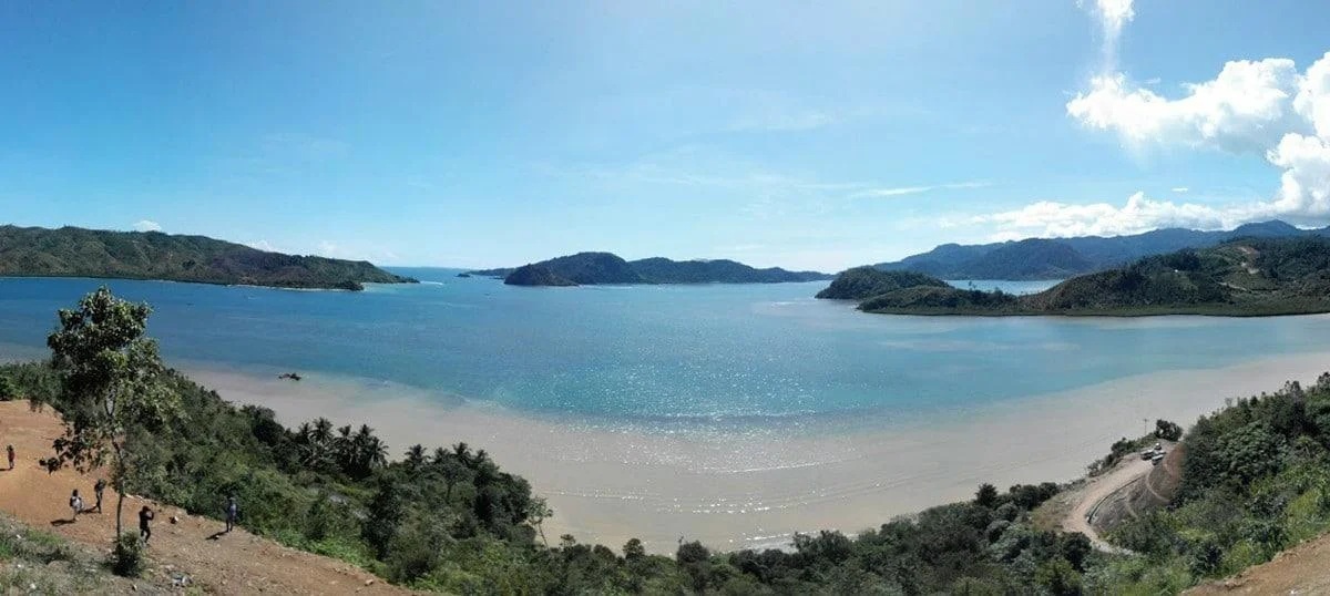
At Bungus, a small village about 25 kilometers south of Padang there is a pleasant swimming beach sheltered in a bay. From here you can hire an outrigger to visit the nearby coral islands which lie about an hour off shore. Bungus is situated in a sheltered bay. There are two good beaches: Carolina and Karang Tinta.
Raya Bung Hatta Botanical Gardens
Raya Bung Hatta Botanical Gardens (15 kilometers from Padang. on the road to Solok) is a botanical garden covering 70,000 hectares. Many kinds of flora and fauna are found here and it is a popular spot to see monkeys. It is located at about 300-1000 meters above sea level so it is cool.
Known in the past as the Setya Mulya Botanic Garden and Taman Hutan Raya Bung Hatta, this botanical garden is home to rare plants and exotic flowers and a variety of unique tropical plants and animal species endemic to Sumatra. Take a walk around here and you will see plants that you might not find anywhere else on earth.
The main attraction of the reserve is the giant flower, the Rafflesia Arnolldi, the biggest flower in the world. It is named after the Bencoolen and Bengkulu Lieutenant Governor of the British Administration, Sir Thomas Stamford Raffles, and the botanist Joseph Arnold who first discovered the flower on the Bukit Barisan mountain slope. This flower is a rare wonder. It takes up to 10 months to mature but only stays in bloom for about 15 days. When it’s in full bloom, it has a diameter of one meter. The plant has no roots, stems but consist of thread like growths on the vines that hosts it. These flowers normally bloom between July and September. The flower is famous not just for it’s enormous size, but for it’s putrid perfume.
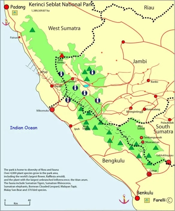
Kerinci Selbat National Park
Kerinci Selbat National Park (south of Padang on the border of West Sumatra and Jambi Provinces) ) is one of the largest park in Indonesia. Covering 15,000 square kilometers, it contains some of the last remaining Sumatran tigers and rhinoceros and embraces 3805-meter-high Gunung Kerinci, an active volcano and the highest mountain in Indonesia, outside West Papua, as wells large tracts of highland and lowland rain forest. There have been a number of sightings here of a Big-Foot-like create called “orang pendok.”
Kerinci Seblat National Park (TNKS) is a natural conservation area Covering one and half million hectare, is located in four provinces: West Sumatra, Jambi, Bengkulu and South Sumatra. In West Sumatra, it covers some 260,000 hectares and is located in Pesisir Selatan and Solok districts. Types of flora protected in TNKS include Kantung Semar (Nephents Ampularia), orchids, and tropical trees among others. Types of fauna protected include Sumatran Tigers, bears, deer, various primates and birds among others. Types of endemic primates protected in TNKS include Simpai, Ungkou, Siamang (Symphanlangus Syndactylus), monkeys, and long tail monkeys among others. Types of birds protected include Rangkong, Tohtor and Kuau birds and eagles among others. Most of these fauna are endangered species.
Greg McCann told mongabay.com; “Something like 150 tigers still prowl the depths of that jungle, in addition to several species of gibbon and even the orang pendak (Sumatran yeti).” But like many rain forest parks “Kercini is under threat. Developers want to put several roads through the center of the park, a project that would open up previously inaccessible terrain to poachers and loggers. We live in a time when almost every natural place is under severe threat, and if you want to see some of last wild places, you had better run very, very fast. In fact, many of the wild places of Southeast Asia are already gone.” [Source: Jeremy Hance, mongabay.com, May 3, 2012]
Getting There: The easiest access to TNKS in West Sumatra is from Painan, Pesisir Selatan district, or Solok Selatan. From Minangkabau international airport, visitors must go to Padang first and continue their journey to Painan by rented car or arranged travel by an agent for about Rp 40,000 to Rp50,000. In Painan, visitors must first report at the Office of Lumpo Resort, which is located behind Painan bus station and the market, and bring along the Entry permit to a Conservation Area (SIMAKSI) from the Central Office of the Management of National Park II (PTN II) in Padang.
Trekking in Kerinci Selbat National Park
Kerinci Selbat National Park is very difficult to get to, has few facilities and restricts trekking to a few areas. Permits are needed. The main access point is Sungaipenuh, a town in Jambi Province. Hikes to the top of Gunung Kerinci can be arranged from the village of Kersik Tuaa, 43 kilometers from Sungaipenuh. Much of the top of the mountain is covered by lose scree. It generally takes two days to reach the crater and one day to get back. There is small greenish lake in the crater. The volcano last erupted in 1934.
Trekkers must be accompanied by rangers assigned to the resort station you check in at. If you like to stay overnight, visitors can also be accompanied by at least one local inhabitant assigned to carry tents and cooking tools.TNKS is a difficult area due to its nearly 90 degree slopes, mud and small rivers with stones. Near The Lumpo Resort is a waterfall called Air Terjun Lumpo which consists of three levels with the highest level of about 80 meters high. From Limau Gadang village border, it will take four to five hours to travel the seven kilometers to the waterfall. Bukit Bontak and Mount Kerinci are located in Solok Selatan. Besides trekking, this protected forest area can also be used for camping.
The main visitor center for the park is the Lumpo Resort. If you do not wish to stay overnight in the forest, TNKS provides inn facility for visitors. On the border between Limau Gadang village and the access point to TNKS, there are several local food stalls where you could enjoy coffee or tea and snacks. If you like to stay in the forest, please bring food supplies from the village, or better yet stock with stuff in a major town or city.
Before visiting TNKS, visitors must first obtain a SIMAKSI permit from the Central Office of the Management of National Park II (PTN II) at Khatib Sulaiman street no.46 Padang, Phone/Fax: 0751-447668. Lumpo Resort office is located right behind Painan market.
If you like to travel around TNKS off Lumpo Resort, it is best to save time by staying in the forest so that you can enjoy the beautiful nature, flora and fauna. It is necessary for visitors to bring extra clothes, supplies, tents, torchlights, salts for prevention against snakes, tobacco to avoid leech bites and anti-mosquito lotion. Despite the difficult environment, it is possible for you to visit Lumpo waterfall and return on the same day. You can come in the morning and return in late afternoon.
Tropical Rainforest Parks of Sumatra
Tropical Rainforest Heritage of Sumatra is UNESCO World Heritage Site According to UNESCO: “The Tropical Rainforest Heritage of Sumatra (TRHS), Indonesia comprises three widely separated National Parks; Gunung Leuser (GLNP), Kerinci Seblat (KSNP) and Bukit Barisan Selatan (BBSNP), and covers a total area of 2,595,124hectares, constituting one of the biggest conservation areas in Southeast Asia. The site is located on Bukit Barisan range and holds the greatest potential for long-term conservation of the diverse biota of Sumatra, including many endangered species. The protected area is home to an estimated 10,000 plant species, including 17 endemic genera; more than 200 mammal species; and some 580 bird species of which 465 are resident and 21 are endemic. Of the mammal species, 22 are Asian, not found elsewhere in the archipelago and 15 are confined to the Indonesian region, including the endemic Sumatran orang-utan. The site also provides biogeographic evidence of the evolution of the island. [Source: UNESCO]
“This serial World Heritage site comprises three widely separated nationally protected areas along the Bukit Barisan mountain range, which runs along the western side of the island of Sumatra. The sites are Gunung Leuser National Park in the northern provinces of Nanggroe Aceh Darussalam and Sumatra Utara; Kerinci Sablat National Park in the south-central provinces of Sumatra Barat, Jambi, Sumatra Selatan and Benkulu; and Bukit Barisan Selatan National Park in the far southern provinces of Sumatra Selatan, Bengkulu and Lampung, partly bordering the south-west coast. The composite site, straddles the equator along the Bukit Barisan mountain range. This runs 1,650 kilometers down the western side of the island studded with active volcanoes. The eastern side of Sumatra is predominantly lowland and in the past has periodically been linked to the Asian mainland.
See Separate Article: TROPICAL RAINFOREST PARKS OF SUMATRA factsanddetails.com
Solok, Twin Lakes, Lake Singkarak and Mount Talang
Solok (65 kilometers from Padang) is a town with fine examples of Minangkabau architecture with fine horn-shaped roofs and outer walls of wood, completely carved and painted in brilliant colors. Nearby are the beautiful twin lakes: Diata and Dibawah. The view from between the two lakes is quite extraordinary.
Twin Lakes (45 kilometers from Padang, in Kerinci Selbat National Park) is a highland lakes in Kerinci Selbat National Park that a number of tour operators West Sumatra stop at. The Lakes of Danau Diatas (Lake Above) and Danau Dibawah (Lake Below) are beautiful natural wonders separated by only a few hundred meters. Located over 1000 meters above sea level, the lakes are covered with a thick mist giving them an eerie beauty. The soil surrounding the lakes comes from volcanic ash from eruptions of Mt Talang. The Twin Lakes are located in the Kerinci-Seblat Reserve, around. The easiest way to the the lakes is to drive, leaving the main Padang-Solok road at Lubukselasih and traveling up the flank of Mr Talang.
Mount Talang is 2,572-meter-high volcano with a beautiful view Twin Lakes and Lake Singkarak from the top. It's one of the six active volcanoes in West Sumatra. It is said that the tea grown here tastes wonderful. For a short visit, it is best if you stay in Padang or Solok. Several accommodation are available should you wish to stay. It's advisable to you hire a four-wheel drive vehicle with a skilled driver as the roads can be quite steep and in poor condition.
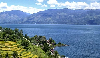
Lake Singkarak (70 kilometers from Padang, 20 kilometers from Solok and about 36 kilometers from Bukittinggi) is an enormous crater lake set within a dramatic volcanic landscape. Spread over two districts; Solok and Tanah Datar, the lake is a massive 1000 hectares. It is the widest lake in Sumatra and the second biggest lake on the island, after Lake Toba. Locally Lake Singkarak is famous for its Bilih fish which is a species of fish that only lives in this lake. This fish is especially unique as it can’t survive anywhere but Lake Singkarak, not even in an aquarium.
There are many hotels near Lake Singkarak (Danau Singkarak) such as those along Solok-Bukittinggi main road and in the Tanah Datar district. The town of Umbilin is on the shore of the lake, its collection of hotels and restaurants make it a convenient place to stay. Boats can be rented from here and it is a good place for swimming, hiking and relaxing.
Sawahlunto: UNESCO World Heritage Coal Mining Town
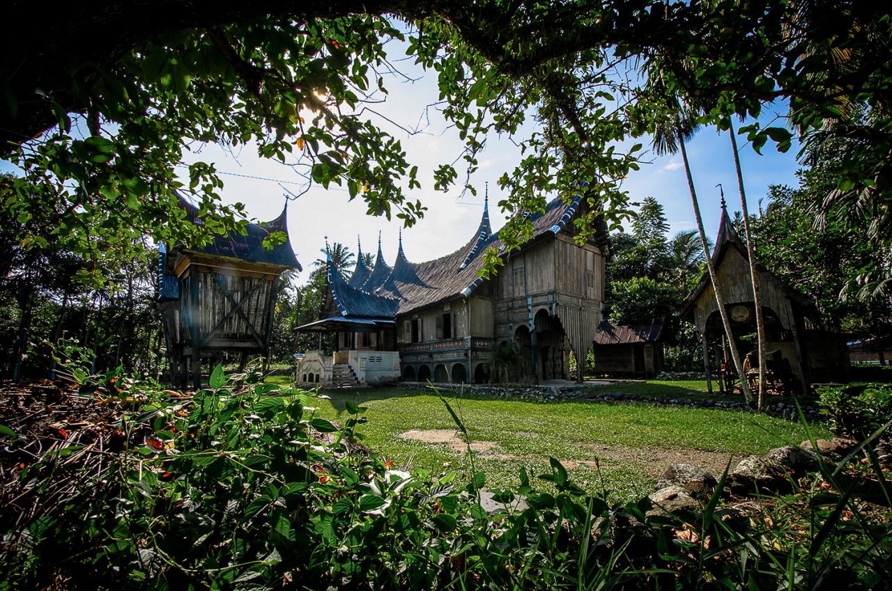
Sawahlunto (95 kilometers from Padang, 138 kilometers from Bukittinggi) is known as the town of the ‘black pearl,’ a reference to the time when it was the center of a major coal mining area. Set on the slopes of Muara Bungo’s valleys and set among rainforests, the town is quite small and occupied by deserted railroad cars, stepped rice fields, and Minangkabau rumah gadang upsweeping roofs. But don’t let this fool you. It is a far from ordinary place and has historical significance.
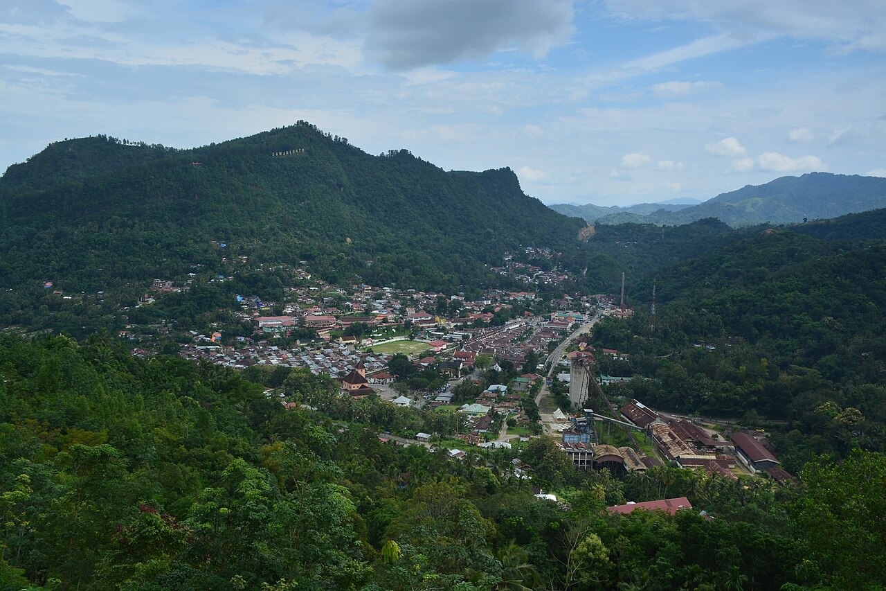
The Ombilin Coal Mining Heritage of Sawahlunto was inscribed as a UNESCO World Site in 2019: According to UNESCO: “Built for the extraction, processing and transport of high-quality coal in an inaccessible region of Sumatra, this industrial site was developed by the Netherlands East Indies’ government in the globally important period of industrialisation from the late 19th to the beginning of the 20th century. The workforce was recruited from the local Minangkabau people and supplemented by Javanese and Chinese contract workers, and convict labourers from Dutch-controlled areas. It comprises the mining site and company town, coal storage facilities at the port of Emmahaven and the railway network linking the mines to the coastal facilities. The Ombilin Coal Mining Heritage was built as an integrated system that enabled the efficient deep-bore extraction, processing, transport and shipment of coal. It is also an outstanding testimony of exchange and fusion between local knowledge and practices and European technology. [Source: UNESCO]
“Ombilin Coal Mining Heritage of Sawahlunto is an outstanding example of a pioneering technological ensemble planned and built by European engineers in their colonies designed to extract strategic coal resources. The technological developments demonstrate both European engineering knowledge and the contribution of local environmental wisdom and traditional practices in the organisation of labour. It also exemplifies the profound and lasting impact of the changes in social relations of production imposed by the European colonial powers in their colonies, which provided both the material and labour inputs that underpinned the world-wide industrialisation of the second half of the 19th century and early 20th century. The many skilled and unskilled workers included local Minangkabau people, Javanese and Chinese contract workers, and convict labourers called ‘chained people’ or orang rantai from Dutch-controlled areas within present-day Indonesia.
“Built to exploit the exceedingly rich Ombilin coal deposits, located in the inaccessible mountains of West Sumatra, the Ombilin Coal Mining Heritage of Sawahlunto is an extensive technological ensemble consisting of twelve components located in three functionally-related areas: Area A, consisting of open pit mines and labyrinthine underground mining tunnels together with on-site coal processing facilities, supported by a full-facility purpose-built mining town nearby at Sawahlunto; Area B, an ingeniously engineered rack mountain railway together with numerous rail bridges and tunnels, linking the mines to the coastal seaport, across 155 kilometers of rugged mountain terrain; and Area C, a dredged harbour and newly-constructed seaport at Emmahaven on Sumatra's Indian Ocean coast from where the coal was shipped throughout the Netherlands East Indies and to Europe.”
There are several hotels in town. Some of them are new and some other are classified as heritage buildings. You can go by bus or a rented car to Sawahlunto from Padang or Bukittinggi. The distance to the quiet town around 2 hours by car from Padang. Follow the road to the town of Solok, and continue the trip on the trans-Sumatra road heading south to Java. After approximately 20 kilometers from Solok, there is a crossroad at Muaro Kalaban. Pay attention to the road sign and direction. Follow the direction to Sawahlunto, and you will pass a winding road with lines of trees that sometimes discourage most travelers to Sawahlunto. Do not worry about the unsettling road as it will eventually take you to the destination.
If you are in Bukittinggi area 138 kilometers from Sawahlunto, take the road to Batusangkar and then follow the same direction as you find the crossroad in Muaro Kalaban. From Batusangkar, the town of Sawahlunto is about 40 kilometers. Taxi from Padang to Sawahlunto is around IDR 200,000 to 250,000 (price is subject to change). A public bus from Padang is IDR 8,000 and a group tour to Sawahlunto in one of the tour operators in Padang is around IDR 20,000 per person. In Sawahlunto, there is daily trip to Muaro Kalaban by an old train as a tourist attraction. It will cost you IDR 75,000. The maximum passenger load is 12 persons chugging along for around 5 kilometers to take one on a nostalgic trip on the old railway lines.
Image Sources: Wikimedia Commons, Indonesia Tourism website
Text Sources: Indonesia Tourism website (indonesia.travel ), Indonesia government websites, UNESCO, Wikipedia, Lonely Planet guides, New York Times, Washington Post, Los Angeles Times, National Geographic, The New Yorker, Bloomberg, Reuters, Associated Press, AFP, Japan News, Yomiuri Shimbun, Compton's Encyclopedia and various books and other publications.
Last updated in December 2025