MOUNTAINS
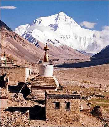
Everest from Rombok Gompa,TibetMountains are often formed where tectonic plates collide and land is pushed upwards or to a lesser extent where magma rises towards the surfaces and causes the ground to swell and bulge or where faults move and crack. New mountains tend be higher than old ones because they have been recently pushed up by these forces. Old mountains are smaller because the forces that built them ended long ago and they have been worn down by millions of years of weathering and erosion. Mountains with craggy peaks, sheer cliffs and spectacular Alpine features are usually that way because they have been carved and chiseled by glaciers and ice.
There are four types of mountains: 1) folded mountains, formed by pressure within the earth that caused uplifting; 2) fault block mountains, formed by shifts along faults; 3) dome mountains, formed by uplift by magma that doesn't break through the surface; and 4) volcanos.
Mountain building features include: 1) anticlines, a folds that points upward like an arch. 2) synclines, folds that points downward; 3) geosynclines, large synclines caused when sediments from mountain ranges bend down the crust. Faults can cause the land to rise or fall. Valleys called grabbens often form and fill with sediment.
The higher you climb the colder it gets. This is because as air rises it expands and therefore cools. On average the temperature drops 1̊F for every 300 feet rise in elevation. Above the freezing line snow falls and may accumulate into glaciers.
Websites and Sources: China Trekking China Trekking ; Summit Climb Summit Climb ; Trekking Tibet Trekking Tibet ; ; Himalayas Wikipedia article on the Himalayas Wikipedia ; Mt. Everest : Wikipedia Wikipedia ;Summit Post Summit Post ; Glaciers: All About Glaciers nsidc.org ; Wikipedia article on Glaciers Wikipedia ; Wikipedia article on Avalanches Wikipedia
See Separate Articles: TIBETAN NATURE factsanddetails.com ; GEOGRAPHY AND WEATHER OF TIBETfactsanddetails.com; MOUNTAINS: TYPES, GEOLOGICAL FEATURES AND MEASURING THEM factsanddetails.com; MT. EVEREST: NAMES, GEOLOGY, WEATHER AND HEIGHT MEASURING ISSUES; factsanddetails.com PLACES IN THE MT. EVEREST AREA factsanddetails.com; HIMALAYAN GLACIERS: IMPORTANCE, AVALANCHES AND DANGEROUS FLOODS factsanddetails.com; GLACIERS: THEIR MECHANICS, STRUCTURE AND VOCABULARY factsanddetails.com ; AVALANCHES factsanddetails.com; MOUNTAIN GLACIERS AND GLOBAL WARMING factsanddetails.com TIBET, THE HIMALAYAS, MELTING GLACIERS AND GLOBAL WARMING factsanddetails.com
RECOMMENDED BOOKS: “Tibet's Sacred Mountain: The Extraordinary Pilgrimage to Mount Kailas” by Russell Johnson and Kerry Moran Amazon.com; “To a Mountain in Tibet” by Colin Thubron Amazon.com “Tibetan Geography” by Yang Qinye and Zheng Du Amazon.com“Geography and Geology of Himalayan Mountains and Tibet” by Sidney Gerald Burrard Amazon.com ; “Physical Geography of Western Tibet” by H. Strachey Amazon.com; “Climate Change in the Himalayas” by G. B. Pant, P. Pradeep Kumar, et al. Amazon.com; “Food and Livelihood Securities in Changing Climate of the Himalaya” by Suresh Chand Rai Amazon.com; “Lonely Planet Tibet 10 by Stephen Lioy , Megan Eaves , et al. (2019) Amazon.com; “Land of Pure Vision: The Sacred Geography of Tibet and the Himalaya” by David Zurick and Eric Valli Amazon.com; Amazon.com; “A Historical Atlas of Tibet” by Karl E. Ryavec Amazon.com; Himalayas: “Geology of the Nepal Himalaya: Regional Perspective of the Classic Collided Orogen” by Megh Raj Dhital Amazon.com; “A Sketch of the Geography and Geology of the Himalaya Mountains and Tibet: The Rivers of the Himalaya and Tibet” by Sidney Gerald Burrard and Henry Hubert Hayde Amazon.com; “Mountains of the Middle Kingdom: Exploring the High Peaks of China and Tibet” by Galen Rowell Amazon.com; “Wild Himalaya” by Stephen Alter Amazon.com; “Himalayas” by Yoshikazu Shirakawa (great photos) Amazon.com; “Himalaya: A Human History” by Ed Douglas, James Cameron Stewart, et al. Amazon.com; “Himalaya: The Exploration and Conquest of the Greatest Mountains on Earth” by Philip Parker and Peter Hillary | Amazon.com;
Measuring Mountains
Mountains do not have "official" heights because there is no officially designated international body that sorts out conflicting claims. The final word on such measurements in the United States is the United States Geological Survey. Outside the United States, for Americans anyway, it is often the National Geographic Society.
To calculate the elevation of mountains early surveyors used precision theodolites (high-resolution telescopes that measure horizontal and vertical angles) to take measurements from several different places. After the data was collected it was taken to surveying offices where men calculated the heights using complex formulas. The explorer Louis Baume wrote "the calculation of the heights of Himalayan peaks is a realm of such erudite complexity than even angels armed with theodolites and plum lines would dare to tread within." [Source: Jon Krakauer, Smithsonian]
Using the method of triangulation, a surveyor used a theodolite to "shoot the angle of the peak's rise" from two different locations, each of which had a known altitude. After measuring the distance between to the two locations, the survey team knew the side and two angles of triangle. Using a trigonometry the length of the other sides could be determined. After allowances were made for the curvature of the earth, atmospheric refraction, and plum line deflection caused by the gravity of a large object like a mountain a height figure could be determined.
HIMALAYAS

The Himalayas as most everyone knows are the highest mountains in the world, with 30 peaks over 24,000 feet. The highest mountains in Europe, North and South America barely top 20,000 feet. The word Himalaya is Sanskrit for "abode of the snow" and a Himal is a massif of mountains. Technically Himalaya is the plural of Himal and there should be no such word as Himalayas.
The Himalayas stretch for 1,500 miles from eastern Tibet and China to a point where India, Pakistan, China and Afghanistan all come together. The mountain kingdoms of Sikkim, Bhutan and Nepal are all contained within the range. The southern side of the Himalayas are like a huge climatic wall. During the summer monsoon winds push massive rain clouds against the mountains squeezing out rain onto some of the wettest places on earth. On the leeward, rain-blocked side of the range, on the Tibetan plateau, are some of the driest and most barren places on the planet.
The Himalaya-Karakoram range contains nine of the world's top ten highest peaks and 96 of the world's 109 peaks over 24,000 feet. If the Karakorum, Pamir, Tian Shan and Hindu Kush ranges and Tibet — which are extensions of the Himalayas into Pakistan, China, Afghanistan and Central Asia — are including in the Himalayas then the 66 highest mountains in the world are in the Himalayas. The 67th highest is Aconcagua in Argentina and Chile
Several of the greatest rivers in the world — the Ganges, Indus, Brahmaputra, Mekong, Yangtze and Yellow rivers — originate in either the Himalayas or the Tibetan plateau. Some people live in valleys nestled between Himalayan ridges but few people actually live on the slopes of the mountains.
See Separate Article HIMALAYAS factsanddetails.com
Geology of the Himalayas
The Himalayas are not just one range of mountains but a series of three parallel ranges that rise up from the plains of India, Pakistan and Bangladesh. Between the massifs and peaks are eroded river gorges, some of the deepest valleys in the world, and massive, slowly-creeping glaciers.
The southernmost range, the Siwalik Hills, barely tops 5000 feet. The Lesser Himalayas, in the middle, vary in altitude between 7,000 and 15,000 feet, and are indented with valleys like the Kathmandu Valley. The third range is known as the Great Himalayas and this is where all the world's biggest peaks are found.
The Himalayas are young mountains. Because of this they experience frequent landslides and rapid erosion, creating precipitous topography with sharp peaks and V-shaped ravines rather than alluvial valleys or lakes. Wind, rain, run off and snow continue shaping the mountains today. The mountains remain about the same height because the rate of erosion is about the same as the amount of uplift. The amount of snow also varies considerably. The greatest depths are recorded in the summer when the monsoons dump large amounts of snow on the higher elevation of the Himalayas. In the winter, high wind scour the landscape and blow snow away.
MT. EVEREST
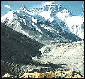
Mt. Everest is 29,028 feet high (5½ miles high). Taller than 21 Empire State buildings piled on top of one another and almost as high as the cruising altitude of Boeing 747 jumbo jets, Mt. Everest is so high that it sometimes penetrates the jet stream, blowing mountain climbers off the top, and dozens of feet have to be subtracted from surveying measurements to compensate for the gravity created by the mountain.
Located on the border of Tibet (China) and Nepal, Mt. Everest is sometimes referred to as the third pole. It was first known to British surveyors — who first sighted it many miles away in Denhra Dun in India and took measurements of its heights from there — as Peak XV. In 1852 it became significant when a Bengali clerk working in an office in Delhi exclaimed "I have discovered the highest mountain in world" after tabulating measurements of Peak XV from different survey stations across northern India in 1849 and 1850.
Mt. Everest is named after the British after Sir George Everest, a Welshman and the Surveyor General of the Great Trigonometric Survey of India and the man in charge of mapping India between 1830 and 1843. Everest most likely never saw the mountain named after him. It is believed he would likely have preferred a local name given to the mountain.
The Nepalese call Mt. Everest "Samgarmatha" ("Goddess of the Universe" or literally “Forehead of the Sky”) and Sherpas and Tibetans call it "Qomolangma" or Chomolungma ("Goddess Mother of the Land"). For them the mountain is sacred and the idea of climbing it, until recently, was strange. According to a Sherpa legend Mt. Everest is the home of a goddess bearing a bowl of food and a mongoose spitting jewels. Mt. Everest is located at about the same latitude as Tampa, Florida.
Climbers say that other mountains are much more difficult to climb than Mt. Everest. Jan Morris, who accompanied the first successful Everest expedition, wrote: “It’s not the most beautiful of mountains — several of its neighbors were shapelier — but whether in fact or simply in the mind, it seems conspicuously nobler than any of them.” Among the most impressive sights at the summit is the pyramid-shapes shadow that Everest produces at sunrise and sunset. Hardly anybody has been it from the summit itself because few climbers are there at those times.
See Separate Article MT. EVEREST factsanddetails.com
Measuring the Height of Mt. Everest
Using a global positional device (GPS) placed on the summit in 1999, scientists at the University of Colorado calculated the height of Mt. Everest to be 29,035 feet, or 8,500 meters.(with a margin of error or plus or minus seven feet). This is seven feet higher than earlier estimates. The new height was recognized by the National Geographic Society and placed on their maps.
The measurements were made after a Seattle-based astronomer claimed in 1987 that K2 in Pakistan might be 29,064 feet high, making it higher that Mt. Everest. The K2 measurement was made measuring the altitude of a knoll near K2 using a 75-pound Doppler receiver (a device that measures distance through analysis of slight variations in the wavelength of radio waves) on the knoll and a satellite passing overhead and then using ordinary triangulation to determine the height of K2.
The first survey of Mt. Everest in the 1850s came up with the altitude figure of 29,002 feet based on measurements taken at six sites in the India plains. A second survey made at the turn of the century determined the height of Mt. Everest was 29,141 feet. In the 1954, when Indian surveyors made 12 readings at locations much closer to the mountain, they came with the widely accepted elevation of 29,028 feet (8,848 meters).
The global positioning device taken to the summit of Mt. Everest in 1998 was placed there by mountain climbers. The devise also determined that Everest is still rising at a rate of about a third of an inch every year and moving northeast at rate of three inches a year. Recently a Chinese mountaineering revised the height of Mt. Everest as four meters lower.
Still there is some debate as to what is the world's highest mountain. Mauna Kea on the island of Hawaii stands 33,480 feet above the ocean floor and 13,796 feet above sea level. According to the Guinness Book of Records, Chimborazo, a 20,560-feet-high volcano in Ecuador, is 7,054 feet further from the center of the earth than Mt. Everest. It's distance from the earth's center is a result of the fact that Chimborazo is only 98 miles from the equator (the earth is slightly flat at the poles and wide at the equator). Chimborazo was thought to bebthe highest mountain in the world until the 1850s.
Glaciers and Avalanches in Tibet and the Himalayas
The Qinghai-Tibetan plateau has the third largest number of glaciers after Antarctica and the Arctic. Glaciers in the Himalayan region make up the greatest concentration of ice outside the polar regions. Mountain glaciers are vital for providing a steady stream of water that feeds streams, rivers, lakes, agriculture and provides water for fish.
According to the World Wildlife Fun (WWF), China has 36,793 glaciers that cover 49,973 square kilometers and have an ice volume of 4,561 square kilometers. Glaciers feed several of the world's great rivers. The Ganges, Indus, Brahmaputra, Mekong, Yangtze and Yellow rivers — are fed by glaciers in the Himalayas and Tibet.
The largest natural avalanches occur in the Himalayas but no one has accurately measured them. Avalanches are landslide of ice and snow. Compared to mythical German monsters that fly without wings, sees without eyes and strikes without hands, they can reach speeds of 200mph; attain a mass of more than a million tons and produce forces 48 times stronger than those needed to demolish a frame house. Severe avalanche can snap trees like toothpicks, dump snow in 30-foot-high heaps and leave behind acres of destroyed buildings. [Source: National Geographic, September 1982]
Sacred Mountains and Lakes of Western Tibet
Prostrating pilgrims
Scenic and historic area of Sacred Mountains and Lakes of Tibet (1,600 kilometers west of Lhasa) was nominated to be a UNESCO World Heritage site in 2017. According to a report submitted to UNESCO: “Located in Burang County, Ngari Prefecture of Tibet Autonomous Region, at an elevation of over 4,500 meters, Scenic and historic area of Sacred Mountains and Lakes is adjacent to Zanda County, Gar County and Gya'gya County, bordering on India and Nepal. ‘Two peaks perching to the north and south, two lakes reflecting with each other in the east and west’ describes the basic natural landscape features of the property, comprising a fairly compact geomorphology unit of ‘two mountains with two lakes in between’, also resulting in unique landscape composed of glaciers, lakes, wetlands and grasslands in this region. ‘Two mountains’ means the Sacred Mountain of Gang Rinpoche (Mount Kailash) )and the Goddess Peak of Naimona'nyi (7,694m), and ‘two lakes’ refers to the Holy Lake of Manasarovar and the Ghost Lake of Lhanag-tso. Unique natural environment has bred particular and rich religions and cultures, which is of world-class [Source: National Commission of the People's Republic of China]
“From natural perspective, the landform features of Scenic and historic area of Sacred Mountains and Lakes have recorded the comprehensive progress of endogenetic force of the collision of the Indian Plate with the Eurasian Plate and exogenic force of glacier and running water. The Gangdisê Mountains, of which Mount Kailash is the main peak, are distributed in the direction of NW-SE, parallel with the Himalayas, of which Naimona'nyi is one of the peaks. It is faulted basin in between, with several groups of lakes scattered, and the group including Lake Manasarovar and Lhanag-tso Lake is one of them. As the main peak of Gangdisê Mountains, Mount Kailash is a pyramidal horn which is formed from the famous ‘Kailash conglomerate’ under the uplift effect of ‘Karakorum Fault’ and the erosion of glacier, grand and vigorous. Gaint U-shaped valleys formed by Quaternary glaciation are distributed around the pyramidal horn of Mount Kailash, dislocated by ‘Karakorum Fault’, forming beheaded valley/betrunk gully, with moraines, gullies and alluvial fans widespread at mountain foot.
“Mount Kailash is the main peak of Gangdisê Mountains, at an elevation of over 6,638 meters, and Lake Manasarovar, located to south of Mount Kailash, is the lake with the highest transparency in China. Snow mountain and bright lake constitute a magnificent plateau landscape under the blue sky and white clouds, which represents the typical natural landscape features of plateau regions. The landform of‘two mountains with two lakes in between’ on the plateau at such high altitudes is also unique worldwide. Diversification of religious beliefs has added a solemn and mysterious color for Scenic and historic area of Sacred Mountains and Lakes. The wonderful fusion of nature and human embodies the unparalleled aesthetic value of Scenic and historic area of Sacred Mountains and Lakes. Location: Burang County, Ngari Prefecture of Tibet Autonomous Region, Coordinates:N31 11 45.53 E81 22 35.65
Mt. Kailash
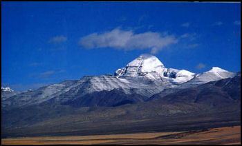
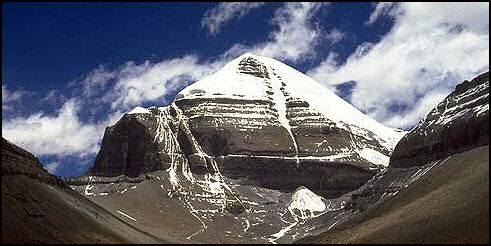
Kalais from a distance MT. Kailash is a 22,028-foot-high (6,714-meter-high) pyramid of ice and rock and the highest peak in the Kailash Range, a group of sacred mountains north of main Himalayan range and the source for three sacred rivers-the Indus, the Brahmaputra and Sutleh. Mt. Kailash is considered to be the center of the universe to Hindus and Buddhists, who regard the mountain an earthly image of the heavenly peak, Mt. Meru. Hindus regard it as the paradise home of Shiva, one of their most important Hindu gods. Tibetan Buddhists believe the 11th-century poet and mystic Milarepa was carried to the peak on the rays of the morning sun.
According to ancient belief, the Ganges descended from Mount Kailash to a spring called Chlimikthungtool, where it was said the sand was composed of emeralds and cat's eyes and people who drank the water became as strong as horses. From there four great rivers — the Ganges, the Brahmaputra, the Indus and Sutleh emerged in pipes in Lake Manasarovar and after circling Mount Kailash and the lake seven times began flowing to the east, south, west and north.
No person has ever climbed Mt. Kailash. In the late 1990s, Beijing gave permission to a Spanish expedition to make the first assault on the summit. Tibetans and others were outraged by such an overt political decision by Beijing and the possibility of the sacrilegious act to Buddhists and Hindus. In the end, the Spanish expedition didn't make the climb. The famous climber Reinhold Messner was invited to climb it in the mid-1980s. He refused. Web Site: Wikipedia Wikipedia Sacred Sites Sacred Sites Summit Post Summit Post
According to a report submitted to UNESCO: Mount Kailash, called ‘Handle of stone mill’ by local Tibetan people, looks like ‘Pyramid’ with four symmetric sides, and its shape is totally different from the surrounding mountain peaks. Its famous symbol of Buddhist swastika, formed by a vertical giant glacial valley and a lateral stratum, can be observed from the south. Though Mount Kailash is not the highest mountain in the region, it is the unique mountain peak which is snow-capped all year round. Wreathed by a sea of clouds and fog, it looks magnificent, unconquerable and mysterious under sunshine.” [Source: National Commission of the People's Republic of China]
Pilgrimage Around Mt. Kailash
Every year, thousands of pilgrims from all over the world gather there to walk around Kailash for worship.The 33-mile trek around Mount Kailash is one of the holiest acts for Buddhists, Hindus, Jains and Bonpos. Pilgrims from all four religions do the trek. Tibetan Buddhists believe that one trek around the mountain cleanses one of his or her sins and 108 circuits (an auspicious number to Tibetan Buddhists) will lead to nirvana in this life.
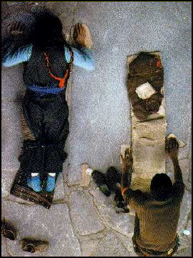
The complete circumambulation of the mountains is known as the kora. Most of the pilgrims follow the Buddhist custom and walk clockwise around the mountain. A few pilgrims walk counterclockwise. They are mostly followers of the animist Bon religion. The main pilgrimage season is in May. Many of them prostrate themselves at regular intervals. Along the route are discarded clothing and drops of blood left by pilgrims who cover the distance on their knees.
Those who prostrate themselves, take one step, make a Tibetan prayer gesture, raise their hands in prayer, and lay down on the ground, their arms extended in front of them. Then they stand up and place their fee where their fingertips had just touched and repeat the process again. Those that do this often wear knee pads, aprons and canvas shoes on their hands and take two three weeks to complete the journey.
See Separate Article WESTERN TIBET AND THE MT. KAILASH AND LAKE MANASAROVAR PILGRIMAGE factsanddetails.com
Darchen is settlement at the base of Mount Kailash where people begin the kora, the pilgrimage trek around the mountain. It is a rough town, often seeming like it is more full of hustlers than pilgrims. In the town are some guest houses with camp beds in narrow concrete rooms and cots for beds. In the high pilgrimage season some tents are erected to absorb the crowds.
Foreigners are usually assigned to an area separated from the other areas. They stay in tents. There is a dining tent and toilet tent. Hawkers and vendors sell all kinds of food and religious items. Darchen sits at about 15,000 feet. Getting There : Darchen is reached by a four-or five'day jeep drive from Lhasa. In many ways it almost easier to get there from Kathmandu, if that can be arranged. Web Site : Travel China Guide (click attractions) Travel China Guide
Mt. Kailas
Shishapangma
Shishapangma (Shisha Pangma, also called Gosainthān) is the 14th-highest mountain in the world, at 8,027 metres (26,335 ft) above sea level. In 1964, it became the last of the 8,000-metre peaks to be climbed. This was due to its location entirely within Tibet and the restrictions on visits by foreign travelers to the region imposed by Chinese authorities. A Chinese team reached the top in 1964, choosing a route that brought climbers up the northwest face along the northeast ridge. The famous American mountain climber Alex Lowe died in a massive avalanche while trying to climb it. Many other mountaineers have died on it slopes.
According to NASA’s Earth Observatory: “The shortest and youngest of the eight-thousand-meter peaks, Shisha Pangma is the only one located entirely within Tibet. (Of the others, three are entirely in Nepal and one in Pakistan. The rest sit along political borders.) Shisha Pangma is known as one of easiest 8000-meter peaks to climb. The steep, craggy south face — much more difficult to climb — rises more than 2,000 meters and has many areas with exposed rock. [Source: earthobservatory.nasa.gov ]
“According to statistics compiled by Eberhard Jurgalski, co-author of On Top of the World: The New Millennium, there had been 302 successful ascents of Shisha Pangma as of March 2012. Twenty-five people had died trying to climb the mountain — a fatality rate of about 8 percent. Many climbers finish on the Central Summit instead of continuing to the slightly higher Main Summit, which requires about an extra hour of climbing along a narrow ridge. British mountaineer Alex MacIntyre described the view along the ridge: “The ridge grew increasingly narrow and sharp. The north side was powdery and steep, impractical and dangerous to traverse; the south side was steeper, vanishing immediately into a jumble of rock and sugary ice.”
K2
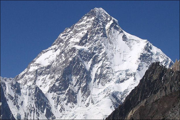
K2 (in the Karakorum range between China and Pakistan) is the second highest mountain in the world after Mt. Everest. It is 8,661 meters (28,251) feet high which is 237 meters (778 feet) less the world's highest peak. The height of these peaks is determined by surveyors who takes measurements from different sides of the mountain and then average the heights together. In 1987 new calculations based on satellite measurements indicated that K2 rose to an elevation of 8,859 meters (29,064 feet) which would make it higher than Everest but the National Geographic Society has not accepted this figure. Similar calculations raise the height of Everest to nearly 30,000 feet.
K2 is in Xinjiang not Tibet but we've included here because its such a cool mountain and I had long thought it could obly be approached from Pakistan. Sometime called Mount Godwin Austen after the British scientist who surveyed it in the 1860, K2 it is a broad glacier shrouded peak that looks like a pyramid on a plateau. Because of it steep slopes, violent summers storms, and high risk of avalanches many mountaineers consider K2 to be a much more difficult climbing challenge than Everest.
Thousands of people have been to the top of Everest. Only a few dozen have summitted K2. Sometimes called "the Savage Mountain" at one point one out of twenty climbers who tried to reach the summit was killed by either, accident, illness or exposure. In 1995 alone, seven people were killed in brutal storm that raged for nine days. Thirty kilometers away a rock climber froze to death in a hanging tent.
It is a 160 kilometer (100 mile) trek just to get to the base of K2. As of 1980 only three expeditions to the top were successful. An Italian one reached the summit in 1954, only a year after Sir Edmund Hillary and Sherpa Tending Norgay reached the top of Everest. A large Japanese group scaled it in 1977.
The first American attempt was in 1953. It like three other expedition ended in failure and took the lives of five climbers. Finally in 1978. AmericansLou Reichardt and Jim Wickwire made it the top. Wickwire was forced to spend the night in a bivouac sack just below the summit and during the effort he said he went temporally insane.
Trekkers generally in Pakistan camp 10 kilometers from K2 at 4541-meter (14,900-foot-high) spot on Godwin Austen Glacier. Most climbing attempts of K2 have been launched from the Pakistan side of the mountain. Few have been launched from Chinese side; only a handful of trekkers have visited the Chinese side of K2.
See Separate Article KARAKORUM-PAMIR REGION OF CHINA factsanddetails.com
Chinese Side of K2 and the Gasherbums
The Tashkurgan section of Xinjiang include of K2. The northern slopes of the Karakoram-Tashkurgan mountains are drier and quite different from the southern slopes in Pakistan. David Hamilton of highadventure.org wrote: “Since my first trip to the Chinese side of the Karakoram in 1989 I have visited the area a total of nine times: two private trips (1989, 1990), five climbing expeditions to Muztag Ata (1998, 2002, 2003, 2006, 2007) and two trekking expeditions to the north side of K2 (2002, 2003). In the summer of 2011 I made my tenth visit leading a private trekking trip to the north base camps of K2 and the Gasherbrums.
The trip could have failed before we left the UK. The Xinjiang-Tibet highway was undergoing major reconstruction work and the Chinese authorities announced that it would only be open to traffic for 3 days in every 10 throughout the summer months....Once this issue was resolved the Chinese visa issuing authorities in the UK placed numerous obstacles in our way, despite the fact that we had obtained all the necessary permits and an official invitation from the China Xinjiang Mountaineering Association.
K2, world's second highest mountain
It was with some relief that the five members of the party were united in Bishkek, capital of Kyrgyzstan...Over two days we drove east reaching the Chinese frontier at the 3,752m Torugart Pass before descending to the city of Kashgar. The following day we set off on the two day drive south on the Xinjiang-Tibet highway” to Mazar and finally Yilik. The next morning we loaded our equipment onto ten camels and left the village together with two Kyrgyz camel drivers and our two Chinese Staff (Mr Li and Mr Liu). After five days of air and road travel it was good to start walking. The trail followed a river valley bounded by high walls of unstable conglomerate until we reached a campsite at the junction of two rivers. It took a further four days to reach Sughet Jangal, the site known locally as the 'Chinese Base Camp' for expeditions climbing K2. On average we travelled for 6-7 hours each day, including about an hour of rests and stops. The days were generally warm and sunny, with a build up of cloud and increasing winds in the afternoons....We generally started walking around 09.00 and this enabled us to reach camp in mid afternoon before the strengthening winds whipped up too much sand and dust.
The route was interesting and varied, passing through steep sided river valleys before crossing the open grasslands of the Aghil Pass (4,870m) and descending to the wide stony valley of the Shagskam River. The river meandered across the floor of the wide valley and we were forced to cross it a few times each day. In many places the water was over a meter deep and we had to climb on top of the baggage camel's loads to cross the fast flowing river. On the final day of the trek to Sughet Jangal we took an optional 'high level' shortcut and were rewarded with excellent views of K2 on a day of clear blue skies. The terrain on the north side of the Karakoram is generally dry and dusty with little vegetation, but Sughet Jangal is one of the largest areas of greenery in the region with a variety of bushes and small trees watered by a clear stream. We spent a rest day here preparing for a three day round trip to visit the Advance BC of K2.
The trail to ABC was too difficult for the camels so this had to be a 'lightweight' trip. All the heavy equipment was left behind at Sughet Jangal. The two camel men plus Mr Liu the cook carried basic camping equipment and food for the team on the long hike to ABC. In the course of a 10hr day we trekked from BC at 3,900m to ABC at 4,700m on a small shelf above the North K2 Glacier. The following day started cloudy and although we knew that K2 was close at hand we had only fleeting glimpses of its outline. The clouds cleared later in the day and we had good views of the dramatic north face of K2 as we trekked back from a vantage point in the middle of the boulder covered glacier.
On our return to Sughet Jangal we were reunited with the camels and the bulk of our equipment for the four day trek to Gasherbrum Base Camp. We retraced our journey along the valley of the Shakskam River as far as the foot of the Aghil Pass before continuing east and following the river upstream towards the glaciers that fed the river. The weather became more unsettled as we approached Gasherbrum BC. By the time we arrived at the campsite there was low cloud in the valley and soon after the rain started. We were scheduled to spend three days exploring the area around Gasherbrum BC. For the first two days we were shrouded in mist and the rain continued to fall. It was with some relief that we woke on the morning of our final day at GBC to find clear skies and a magnificent view of the snow covered peaks overlooking camp.
We spent the day exploring the ice pinnacles on the North Gasherbrum Glacier and photographing the high peaks of the Gasherbrum range. Gasherbrum I and Gasherbrum II were the most easily identifiable features. Scanning the skyline from left to right the ridgeline of the Urdok peaks rose to the summit of Gasherbrum I (8,068m) then fell to the Gasherbrum Pass (6,511m) before rising again to the summit of Gasherbrum II (8,035m). Beyond GII the topography was more complex with several high subsidiary summits making it difficult to identify the summits of Gasherbrum III (7,946m) and Gasherbrum IV (7,932m). A decade ago I spent several summers climbing some of these peaks from the Pakistan side and looking down onto the glaciers and valleys on the Chinese side. It was interesting to be able to look up at these same summits from the north side of the range.
The last “day the trek was shortened considerably by the arrival of our vehicles that came to find us long before we reached Yilik. It still required several hours for the camels to arrive and be unloaded before we could complete the formalities at the Chinese army post and start the long journey northward to Kashgar. The party were anxious to avoid a repeat stay at the rather basic Kun Lun hotel in Kudu where we had stopped on the outward journey. We therefore drove late into the night, through the roadworks, to reach the relative comfort of Yecheng. The next day better roads took us out of the mountains and across a dry and sandy landscape to Kashgar.
Kunlun Mountains
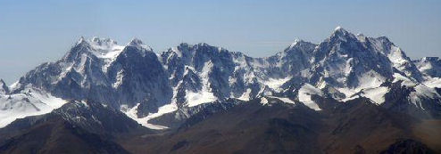
The Kunlun Mountains comprise one of the longest mountain chains in Asia, extending for more than 3,000 kilometers (1,900 miles). In a broad sense, the range forms the northern edge of the Tibetan Plateau south of the Tarim Basin. Located in Tibet, Qinghai and Xinjiang, the Kunlun Shan sits to the south of the Gobi Desert, the Tarim Basin, Taklamakan Desert, the Altyn Tagh. and the Tibet-Xinjiang highway. The range has very few roads and in its 3,000 km length is crossed by only two. In the west, Highway 219 traverses the range en route from Yecheng, Xinjiang to Lhatse, Tibet. Further east, Highway 109 crosses between Lhasa and Golmud. [Range coordinates: 36°N 84°E]
The definition of the Kunlun Shan range varies and the origin of the name appears to come from a semi-mythical location in the classical Chinese text Classic of Mountains and Seas.. Ancient sources use the term to refer to a mountain belt in the center of China, taken to mean the Altyn Tagh and the Qilian and Qin Mountains. The great ancient Chinese historian Sima Qian (Records of the Grand Historian, scroll 123) said that Han Emperor Han Wudi (ruled 141-87 B.C.) sent men to find the source of the Yellow River and gave the name Kunlun to the mountains at its source. [Source: Wikipedia]
From the Pamirs of Tajikistan, the Kunlun Mountains run east along the border between Xinjiang and Tibet to Qinghai province. A number of important rivers flow from the range including the Karakash River ('Black Jade River') and the Yurungkash River ('White Jade River'), which flow through the Khotan Oasis into the Taklamakan Desert. Altyn-Tagh or Altun Range is one of the chief northern ranges of the Kunlun. Its northeastern extension Qilian Shan is another main northern range of the Kunlun. The main extension in the south is the Min Shan. Bayan Har Mountains, a southern branch of the Kunlun Mountains, forms the watershed the Yangtze River and the Yellow River basins.
The Kunlun Mountains highest point is 7,167 meter (23,514 foot) -high Liushi Shan (the Kunlun Goddess in the Keriya area in western Kunlun Shan. Some say the Kunlun extends to northwest and includes 7,649-meter-high Kongur Tagh and 7,546 meter-high Muztagh Ata but the these mountains are more associated with the Pamirs and kind of stand by themselves anyway. The Arka Tagh (Arch Mountain) lies in the center of the Kunlun Shan; its highest points are Ulugh Muztagh (6,973 m) and Bukadaban Feng (6,860 m). In the eastern Kunlun Shan the highest peaks are Yuzhu Peak (6,224 m) and Amne Machin [also Dradullungshong] (6,282 m); the latter is the eastern major peak in Kunlun Shan range and is thus considered as the eastern edge of Kunlun Shan range.
Geology and Mythology of the Kunlun Mountains
The Kunlun mountain range formed at the northern edges of the Cimmerian Plate during its collision, in the Late Triassic (237 million to 201 million years ago). with Siberia, which resulted in the closing of the Paleo-Tethys Ocean. The Kunlun are not volcanic mountains, but over 70 volcanic cones have been counted there, with the highest one being 5,808 meters (19,055 feet) highest, making them the highest volcano in Asia and China and second highest in the Eastern Hemisphere (after Mount Kilimanjaro). The last known eruption was in May 1951. [Source: Wikipedia]
Kunlun is originally the name of a mythical mountain believed to be a Taoist paradise. The first to visit this paradise was, according to the legends, King Mu (976-922 B.C.) of the Zhou Dynasty. He supposedly discovered there the Jade Palace of the Yellow Emperor, the mythical originator of Chinese culture, and met Hsi Wang Mu (Xi Wang Mu), the 'Spirit Mother of the West' usually called the 'Queen Mother of the West', was the object of an ancient religious cult which reached its peak in the Han Dynasty.
The Kunlun mountains (spelled "Kuen-Lun" in the book) are described as the location of the Shangri-La monastery in the 1933 novel Lost Horizon by English writer James Hilton. The mountains are the site of the fictional city of K'un Lun in the Marvel Comics Iron Fist series and the TV show of the same name.
Image Sources: Wikimedia Commons, Nolls China Web site; CNTO; Perrochon photo site; Beifan.com; University of Washington; Ohio State University; UNESCO; Wikipedia; Julie Chao photo site
Text Sources: CNTO (China National Tourist Organization), China.org, UNESCO, reports submitted to UNESCO, Wikipedia, Lonely Planet guides, New York Times, Washington Post, Los Angeles Times, National Geographic, China Daily, Xinhua, Global Times, The New Yorker, Time, Newsweek, Bloomberg, Reuters, Associated Press, AFP, Compton's Encyclopedia and various books and other publications.
Updated in July 2020
