MT. EVEREST
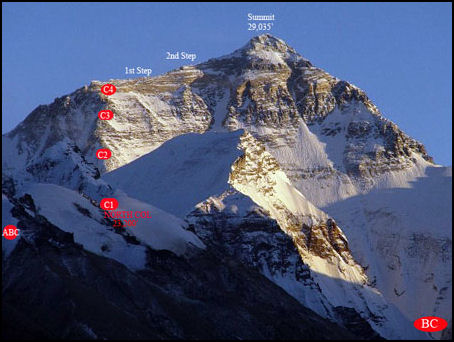
Climbing routes on Tibetan side The currently recognized height of Mt. Everest is 8,848.86 meters (29,031.7 feet). For a long time it was listed as being 8,848 meters (29,029 feet) high. That is almost nine kilometers (5½ miles) high. Taller than 21 Empire State buildings piled on top of one another and almost as high as the cruising altitude of Boeing 747 jumbo jets, Mt. Everest is so high that it sometimes penetrates the jet stream, blowing mountain climbers off the top, and dozens of feet have to be subtracted from surveying measurements to compensate for the gravity created by the mountain. [Coordinates 27°58'60N, 86°55'60E]
Mt. Everest is located at about the same latitude as Tampa, Florida. The rocks making up the mountain are 60 million years old. Located on the border of Tibet (China) and Nepal, Mt. Everest is sometimes referred to as the third pole. It was first known to British surveyors — who first sighted it many miles away in Denhra Dun in India and took measurements of its heights from there — as Peak XV. In 1852 it became significant when a Bengali clerk working in an office in Delhi exclaimed "I have discovered the highest mountain in world" after tabulating measurements of Peak XV from different survey stations across northern India in 1849 and 1850.
Climbers say that other mountains are much more difficult to climb than Mt. Everest. Jan Morris, who accompanied Sir Edmund Hillary and Tenzing Norgay on the first successful Everest expedition in May 1953, wrote: “It’s not the most beautiful of mountains — several of its neighbors were shapelier — but whether in fact or simply in the mind, it seems conspicuously nobler than any of them.” Among the most impressive sights at the summit is the pyramid-shapes shadow that Everest produces at sunrise and sunset. Hardly anybody has been it from the summit itself because few climbers are there at those times. Web Sites: Wikipedia Wikipedia
See Separate Articles: HIMALAYAS factsanddetails.com ; MOUNTAINS: TYPES, GEOLOGICAL FEATURES AND MEASURING THEM factsanddetails.com; PLACES IN THE MT. EVEREST AREA factsanddetails.com; HIMALAYAN GLACIERS: IMPORTANCE, AVALANCHES AND DANGEROUS FLOODS factsanddetails.com; GLACIERS: THEIR MECHANICS, STRUCTURE AND VOCABULARY factsanddetails.com ; AVALANCHES factsanddetails.com; MOUNTAIN GLACIERS AND GLOBAL WARMING factsanddetails.com TIBET, THE HIMALAYAS, MELTING GLACIERS AND GLOBAL WARMING factsanddetails.com; Mount Everest.net Mount Everest.net Summit Post Summit Post
Names and Naming of Mt. Everest
Mt. Everest is named after the British after Sir George Everest, a Welshman and the Surveyor General of the Great Trigonometric Survey of India and the man in charge of mapping India between 1830 and 1843. Everest most likely never saw the mountain named after him and it is believed he would likely have preferred a local name given to tthe mountain.
Everest had no direct connection with the mountain but was responsible for hiring Andrew Scott Waugh, who made the first formal observations of the mountain, and Radhanath Sikdar, who calculated its height. Mount Everest was originally known as Peak "B" and later as Peak XV. In March 1856, Waugh announced to the Royal Geographical Society that his team believed that Peak XV was the highest in the world, and suggested naming it "after my illustrious predecessor", as it was "without any local name that we can discover" and the "native appellation, if it has any, will not very likely be ascertained before we are allowed to penetrate into Nepal".
The Nepalese call Mt. Everest "Samgarmatha" ("Goddess of the Universe" or literally “Forehead of the Sky” pr "Head reaching up to the sky’" . In 1938 after much research, according to the Kathmandu Post, the Nepalese historian Baburam Acharya found that. ‘Sagar’ means "heaven" or "sky" and "matha’ means head or crest in Sanskrit Sherpas and Tibetans call Everest "Qomolangma" or Chomolungma ("Goddess Mother of the Land"). For them the mountain is sacred and the idea of climbing it, until recently, was strange. According to a Sherpa legend Mt. Everest is the home of a goddess bearing a bowl of food and a mongoose spitting jewels.
Measuring the Height of Mt. Everest
Using a global positional device (GPS) placed on the summit in 1999, scientists at the University of Colorado calculated the height of Mt. Everest to be 29,035 feet, or 8,500 meters.(with a margin of error or plus or minus seven feet). This is seven feet higher than earlier estimates. The new height was recognized by the National Geographic Society and placed on their maps.
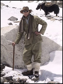
Everest climber in the old days
The measurements were made after a Seattle-based astronomer claimed in 1987 that K2 in Pakistan might be 29,064 feet high, making it higher that Mt. Everest. The K2 measurement was made measuring the altitude of a knoll near K2 using a 75-pound Doppler receiver (a device that measures distance through analysis of slight variations in the wavelength of radio waves) on the knoll and a satellite passing overhead and then using ordinary triangulation to determine the height of K2.
The first survey of Mt. Everest in the 1850s came up with the altitude figure of 29,002 feet based on measurements taken at six sites in the India plains. A second survey made at the turn of the century determined the height of Mt. Everest was 29,141 feet. In the 1954, when Indian surveyors made 12 readings at locations much closer to the mountain, they came with the widely accepted elevation of 29,029 feet (8,848 meters).
The global positioning device taken to the summit of Mt. Everest in 1998 was placed there by mountain climbers. The devise also determined that Everest is still rising at a rate of about a third of an inch every year and moving northeast at rate of three inches a year. Recently a Chinese mountaineering revised the height of Mt. Everest as four meters lower.
Still there is some debate as to what is the world's highest mountain. Mauna Kea on the island of Hawaii stands 10,205 meters (33,480 feet) above the ocean floor and 4,205 meters (13,796 feet) above sea level. According to the Guinness Book of Records, Chimborazo, a 6,267-meter (20,560 foot) -high volcano in Ecuador, is 2,150 meters (7,054 feet) further from the center of the earth than Mt. Everest. It's distance from the earth's center is a result of the fact that Chimborazo is only 160 kilometers (98 miles) from the equator (the earth is slightly flat at the poles and wide at the equator). Chimborazo was thought to be the highest mountain in the world until the 1850s. By some reckoning Hawaii’s Mauna Kea is the world's tallest mountain. From top to bottom it is over 10,000 meters (32,280 feet) — 4,207.3 meter (13,803 feet) above sea level and around 6,000 meters (19,685 feet) below the sea. Chimborazo is 6.4 million meter (21 million feet) or 6,384 kilometers (3,967 miles) from the center of the earth.
Surveying Mt. Everest
In 1848 Andrew Waugh, Surveyor General of India, identified “peak b” as possibly the highest mountain in the world. In 1854, “Peak b” is renamed Peak XV. Overcoming huge obstacles, Waughed measured Peak XV to be at 8,840 meters (29,002 feet), remarkably close to its currently recognized height 8,848.86 meters (29,031.7 feet). In 1865 The Royal Geographical Society officially adopts Mt. Everest as the mountain’s name, after Sir George Everest, first Surveyor-General of India. Everest himself, reportedly favored a local name. In the1950s, an Indian survey team measured Everest at 29,029 feet. [Source: Robin Pagnamenta, The Times, June 2, 2012]
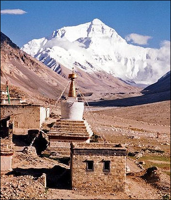
Everest from Rombok Gompa,TibetThe first photograph of Everest was taken in 1904 from a Tibetan village 151 kilometers (94 miles away). A British Army captain, traveling in disguise, came within 64 kilometers (40 miles) of Everest 1913. At that time Tibet was not part of China and was closed to outsiders. In 1920 the 13th Dalai Lama opened Tibet to foreigners. That year a British party explored a route to Everest from the north. The first attempt to climb Everest — by a British team in 1921, ended in failure. The first people died trying to climb Everest in 1922. That year seven Sherpas died in an avalanche. [Source: Robin Pagnamenta, The Times, June 2, 2012]
According to Guinness World Records: Despite being the highest peak on earth, Everest is NOT the tallest mountain? No - at 8,848 meters (29,029 feet), Everest is the highest mountain on Earth – in that it reaches the highest altitude – but the tallest is actually Mauna Kea in Hawaii, USA. You can only see 4,205 meters (13,796 feet) of it (the rest is underwater), but from its submarine base in the Hawaiian Trough, it reaches up for a total of 10,205 meters (33,480 feet).
Because the original measurements of Mt. Everest were made from the faraway plains of India, the height calculations were corrected by as much as 1,375 feet to compensate for refraction alone. Moreover, the chain of triangulation locations began 1,000 miles way in Madras. For K2, they began 1,700 miles away in Madras. The early surveyors were prohibited from crossing into Tibet by the Chinese emperor. To get around this the British hired local tribesmen who disguised their surveyor chains as prayer beads. These tribesmen were educated men known as "pandits." The word "pundit," an expression which originally meant "learned man" was derived from the name of this group. All measurements of Mt. Everest are based on the elevation of the snowcap on the summit not the summit itself. No one knows how deep the snow is and it may vary as much as three feet in the course of a year.
Issues Involved with Measuring the Height of Mt. Everest
According to the New York Times: “In the 19th century, the height of Everest was calculated by measuring the angles between the top of the mountain and points on the ground whose positions relative to the average height of the sea were already known. Now, surveyors place a global positioning system receiver on the summit ice for an hour, and mathematically calculate the height of the sea from satellites and measurements of gravity at the base. [Source: Bhadra Sharma and Kai Schultz, New York Times, February 3, 2018]
The calculation used to determine the height of Mt. Everest is inexact and subject to multiple factors, including things like wind speed and amount of snow and ice at the summit. Bhadra Sharma and Kai Schultz wrote in the New York Times: “In the past, geologists have disagreed about what to include in their calculations: Should the summit’s snowcap be included? Or should surveyors drill down to the peak’s rock base? What about the recent earthquakes in Nepal...Or the fact that wind speed affects how much snow covers the summit at any given time?
“Then there is the challenge of geography: Reaching the summit of Everest is only possible a few weeks each year, and measuring the mountain’s height from sea level has presented difficulties in the past. But teams from around the world, including China, Denmark, Italy, India and the United States, have come up with other calculations, which have sometimes strayed a little bit higher, or a little bit lower, than that figure. Italy, in 1992, lopped seven feet off the standard height, measuring it at 29,022 feet. In 1999, a measurement by American scientists pushed the peak a little higher, saying the mountain reached 29,035 feet. Alan Arnette, a well-known mountaineer, said any measurement of the summit is still “a snapshot in time,” with different levels of ice accumulation causing variations in the height. he health of the nation.”
History of Measuring Mt. Everest
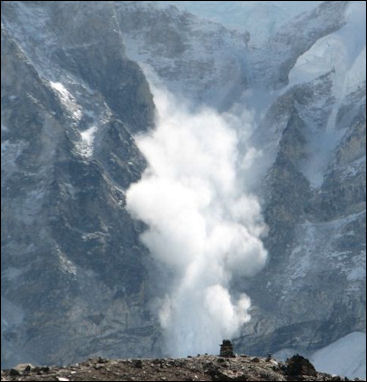
Avalanche on Everest
Radhanath Sikdar, an Indian mathematician and surveyor, was the first person to identify the mountain that would later be called Everest as the tallest peak on the world. Bhadra Sharma and Kai Schultz wrote in the New York Times: “A team hired by Sir George Everest, a former surveyor general of India, assembled near India’s border with Nepal. It was there that Radhanath Sikdar, a young Indian mathematician, and a group of so-called human computers, used triangulation to collect data on the mountain, known then as Peak XV. Folklore has it that when Mr. Sikdar finished calculating his findings in 1852, he made a beeline for the office of a superior stationed in the foothills of the Himalayas and announced that he had “discovered the highest mountain in the world.” [Source: Bhadra Sharma and Kai Schultz, New York Times, February 3, 2018]
“In 1856, the height of Peak XV was recorded at 29,002 feet, a number remarkably close to the height recognized by climbing bodies today. But Mr. Sikdar’s contributions were pushed to the footnotes, and Peak XV was eventually renamed in honor of Mr. Everest.
“About 100 years later, when Nepal cracked open its borders to foreigners, scientists moved their measurement tools closer to the mountain, which lies partly in Tibet. In the mid-1950s, the height was recognized as about 29,029 feet, making it the world’s tallest mountain above sea level.
In 1933, the Houston Everest Flight Expedition, lead by Stewart Blacker, used areial photography to map Everest, pushing their small propeller-driven plane to altitudes over 8,000 meters (26,246 feet). During the flight temperatures changed from 28 degrees C (82 degrees F) to -41 degrees C (-41 degrees F) in a matter of minutes. [Source: Rolex]
Nepalese Pride, China and Measuring the Height of Mt. Everest
Measurement expeditions to determine the height of Mt. Everest have typically not included experts from Nepal. In 2019, for the first time, Nepal sent its own team to the summit to settle the Everest height issue once and for all — with Nepalese input. Bhadra Sharma and Kai Schultz wrote in the New York Times: “In addition to the science, a bit of national pride is at stake. “Mt. Everest is our treasure,” said Buddhi Narayan Shrestha, the former director general of Nepal’s Department of Survey. “What will happen if foreign experts continue to reduce the height of our mountain without us participating?” [Source: Bhadra Sharma and Kai Schultz, New York Times, February 3, 2018]
The first recorded attempt to measure Everest’s height came in the mid-19th century, when Nepal was a Hindu monarchy, closed to outsiders. Government officials in Nepal have been selective about recognizing data generated by other countries, with some measurements less welcome than others. Take the case of China, which shares the summit with Nepal. After Chinese surveyors assessed Everest’s summit in 2005, measuring the height both from the peak’s rock base and from the top of the snowfall, a heated dispute over the height ensued.
“Ang Tshering Sherpa, the former head of the Nepal Mountaineering Association, said China applied pressure on the Nepal’s government and an international climbing body to recognize 29,017 feet, the measurement from the rock base, as the mountain’s new height. But Nepal held its ground, and China recently backed down, Mr. Sherpa said, apparently in response to a drop in climbers tackling the mountain from the Tibet side. Having those few extra feet recognized on summit certificates was enough for some mountaineers to switch routes, opting to climb from, and spend money in, Nepal. “China changed its own findings last year after the number of climbers summiting Mt. Everest from the northern side significantly decreased,” Mr. Sherpa said.
“A proposal from India to jointly measure the mountain with Nepal was passed over. Last year, Swarna Subba Rao, then the surveyor general of India, allocated resources to send a 30-member team of mountaineers to gather data from the summit. Nepal, which has had frosty relations with India in the past, “humbly declined” the proposal. “We are capable of the job,” said Ganesh Prasad Bhatta, the director general of Nepal’s Department of Survey, which is overseeing Nepal’s measurement project.
“To prepare for the country’s own expedition, Nepali surveyors” collected “measurements along the country’s southern plains, where they plan to calculate sea level. A team of Sherpas are also being trained to bring a GPS receiver to the summit. The cost to measure the mountain is estimated at $250,000. Arnette, the mountaineer, questioned whether the expedition was worth what it would cost Nepal. “As a mountaineer, I would like to see the results,” Mr. Arnette said, “but as someone who supports the Nepal people, the money could be spent on jobs, food, clean air and other programs more important to the health of the nation.”
Mt. Everest Grows by Nearly a Meter to 8,848.86 Meters (29,032 Feet)
Measurements made of Mt. Everest in 2019 and 2020 indicated it was almost a meter higher than before — at 8,848.86 meters (29,032 feet). The BBC reported: “Some geologists believe the 2015 earthquake may have changed Everest's height. The mountain is 0.86m higher than had been previously officially calculated, Nepal and China have jointly announced. Until now the countries differed over whether to add the snow cap on top. The new height is 8,848.86 meters. China's previous official measurement of 8,844.43 meters (29,017 feet) had put the mountain nearly four meters lower than Nepal's. [Source: Navin Singh Khadka, BBC, December 8, 2020]
Officials at Nepal's foreign ministry and department of survey said surveyors from both countries had co-ordinated to agree on the new height. Chinese authorities had said previously Mt. Everest should be measured to its rock height, while Nepalese authorities argued the snow on top of the summit should be included.
The Chinese surveyors had calculated their figure after they measured the mountain in 2005. Nepal's government officials told the BBC in 2012 that they were under pressure from China to accept the Chinese height and therefore they had decided to go for a fresh measurement to "set the record straight once and for all". The 8,848 meter (29,027 feet) height Nepal had been using for Mt. Everest was determined by the Survey of India in 1954, but for the first time the country has now conducted its own measurement of the summit.
Did Mt. Everest Get Bigger Because of the 2015 Earthquake in Nepal
Navin Singh Khadka of the BBC wrote: “Some geologists have suggested a major earthquake in 2015 may have had an impact on Mt. Everest's height. The 7.8 magnitude earthquake killed nearly 9,000 people in Nepal, and caused an avalanche which buried parts of the base camp at the mountain. At least 18 climbers were killed. Some geologists said the earthquake may have caused Everest's snow cap to shrink. [Source: Navin Singh Khadka, BBC, December 8, 2020]
“Scientists had found that some other Himalayan peaks such as Langtang Himal, mostly to the north of Kathmandu and close to the epicenter, had reduced in height by approximately a meter after the earthquake. Others have argued that Mt. Everest, like other Himalayan peaks, may have actually grown over time because of the shifting tectonic plates it sits on. But experts say major earthquakes can result in that process being reversed. "The 2015 earthquake is also a major reason why we re-measured the mountain," said Mr Dhakal.
John Elliott, a geophysicist at the University of Leeds in England, who has used satellite data to try to measure changes in heights Himalayan mountains after the 2015 earthquake, told Live Science: “I can’t say one way or the other whether Everest was affected. Because Everest is far away from the epicenter, we cannot conclusively say it went down; it is within the error of our measurement.”
Roger Bilham, a geologist at the University of Colorado Boulder, told the New York Times that “Everest’s location in the zone of compression between southern Tibet and India means it sinks during earthquakes and rises in the period between them. A major earthquake in 1934 lowered the mountain by 63 centimeters, or about two feet, according to data provided by Mr. Bilham.” [Source: Bhadra Sharma and Kai Schultz, New York Times, February 3, 2018]
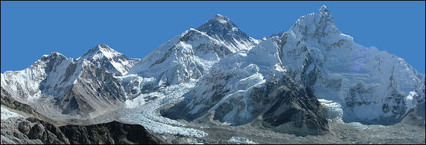
Everest and Nubtse
According to Chinese research published in June 2015, three months after earthquake hit Nepal, the earthquake moved Mount Everest three centimeters (just over an inch) to the southwest, but did not change its height. The 7.8-magnitude quake reversed the gradual northeasterly course of the world's highest peak, the National Administration of Surveying, Mapping and Geoinformation said in a report published in Chinese state media. The report said Everest had moved 40 centimeters to the northeast over the past decade at a speed of four centimeters a year, and risen three centimeters over the same period.[Source: AFP, June 16, 2015] . Bilham agreed with the Chinese findings. But he said the focus should not be on Everest, calling the peak "a lump of uneroded rock that just happens to have survived a little bit higher than all the other rocks in the Himalaya". “The Everest region was a mere bystander, and was pulled slightly by this movement by a few centimeters south and a little bit down," he told AFP. More than 8,700 people were killed in the April 25 quake and a major aftershock on May 12, which also triggered landslides and destroyed half a million homes, leaving thousands without shelter.
How Mt. Everest Was Officially Re-Measured
Navin Singh Khadka of the BBC wrote: The heights of mountains are measured with the mean sea level as the base. So it's less about working out the where the top is, than where the bottom would be. Nepal used the Bay of Bengal as its sea level, but India had already surveyed a point closer to Everest, near the India-Nepal border, from the bay, and was able to provide the Nepalese surveyors with the height at that point. From there, Nepal built a network of line-of-sight stations stretching nearly 250 kilometers (155 miles) to the point Everest first become visible, creating a chain of points it could measure and add together. The Chinese surveyors, according to the state-run China Daily, used the Yellow Sea in the eastern province of Shandong as their sea-level base. [Source: Navin Singh Khadka, BBC, December 8, 2020]
“Surveyors from both sides also used trigonometry formulas to calculate the height of the summit. The formulas they used calculate the height of a triangle by multiplying its base with its angles. But for all the clever ground work, someone still needs to be on top of the mountain. The Nepalese surveyors went up to the summit last year, while the Chinese surveyors went up in May, becoming the only team to reach the top in 2020, after Nepal suspended all expeditions during the coronavirus pandemic and China banned foreign travellers.
“Nepalese officials said they used 12 different lower peaks looking up at the Everest summit for their trigonometry calculations, to achieve a more precise result. Chinese media reported that Chinese surveyors used the same method. "Once the surveyor's beacon had been placed on the summit, surveyors at stations around the summit measured the distance from the six points to the beacon, which meant at least six triangles could be calculated to determine the mountain's height," Jiang Tao, associate researcher at the Chinese academy of surveying and mapping, told the state-run China Daily.
“Both sides also used Global Navigation Satellite Systems to receive elevation data from numerous receivers in their calculations. China has previously conducted two height measurements of Mt. Everest - first in 1975 and then in 2005. Members of the second survey team installed a Chinese version of a GPS device on the summit, according to the Himalayan Database. This time the Chinese surveyors used China's BeiDou navigation satellite system, which is believed to be a rival to the US-owned Global Positioning System, or GPS. "Using the system, snow depth, weather and wind speed would also be measured to help glacier monitoring and for ecological protection," China's state news agency Xinhua reported. Nepalese surveyors used GPS to make their calculations. "We processed this data using internationally accepted methodology to determine the height of Mt. Everest," Mr Dhakal told the BBC.
Four Nepalese land surveyors spent two years training for the mission, before heading to the summit. "Before this, we had never done the measurement ourselves," Damodar Dhakal, spokesman at Nepal's department of survey, told the BBC. "Now that we have a young, technical team [who could also go to the Everest summit], we could do it on our own," Mr Dhakal said. Nepal's lead surveyor Khimlal Gautam lost his toe due to frostbite while on the summit to install height-measuring equipment last year. "For summiteers, scaling the highest peak means a great accomplishment. For us, it was just the beginning," Mr Gautam had told BBC Nepali after his return. "Unlike other surveys of the Everest in the past, we chose 03: 00 to minimise errors that could have been caused because of sunlight in the day time."
Mahalangur Himal
Mt. Everest is located in the Mahalangur Himal sub-range of the Himalayas, which includes Mt. Everest, Lhotse, Makalu, and Cho Oyu — four of Earth's six highest peaks. On the Tibetan side the sub-range is drained by the Rongbuk and Kangshung Glaciers. On the Nepali side it is drained by Barun, Ngojumba and Khumbu Glaciers and a few others. All are tributaries to the Koshi River via the Arun River to the north and east, and Dudh Kosi to the south. The Koshi Rivers flows through Tibet, Nepal and India and winds near Kanchenjunga, the world’s third highest mountain through one of the deepest gorges in the world and eventually makes its way to rivers that empty into the Ganges. The Khumbu region of Nepal is the best known part of the Mahalangurs as it contains the most popular trekking and mountaineering (the South Col route) routes to Everest. [Source: Wikipedia]
The Mahalangur Himal can be divided into three subsections: 1) Makalu nearest the Arun River and along the Nepal-China border, with Makalu (8463 meters, 27,765 feet), Chomo Lonzo (7790 meters, 25,557 feet) south of the Kama valley in Tibet, Kangchungtse or Makalu II (7678 meters, 25,190 feet), Peak 7199 and some ten others over 6000 meters;
2) Barun inside Nepal and south of the Makalu section, with Chamlang (7319 meters, 24,012 feet) and Chamlang East (7235 meters, 23,736 feet), Peak 7316, Baruntse (7129 meters, 23,389 feet), Ama Dablam (6812 meters, 22349 feet) and about 17 others over 6000 meters;
3) Khumbu along the international border west of the Makalu section, with the Everest massif: Everest (8848 meters, 29,029 feet), Lhotse (8516 meters, 27,940 feet), Nuptse (7855 meters, 25,771 feet) and Changtse (7580 meters, 25,755 feet). West of Everest are Pumori (7161 meters, 23,494 feet) and Cho Oyu (8201 meters, 26,906 feet) with around 20 others over 7000 meters and 36 over 6000 meters.
Geology of Mt. Everest
Much of the rock on Everest at least has elements that originated 500 million to 400 million years but was thrust upwards by tectonic activity 60 million to 40 million years ago. The mostly sedimentary and metamorphic rocks found in the mountains have been faulted southward over continental crust composed of Archean granulites of the Indian Plate during the Cenozoic collision of India with Asia around 65 million years ago. The main rock formations consist of marine sediments that accumulated within the continental shelf of the northern passive continental margin of India before it collided with Asia. The Cenozoic collision of India with Asia subsequently deformed and metamorphosed these strata as it thrust them southward and upward. The formation at the base of Everest consists of a sequence of high-grade metamorphic and granitic rocks that were derived from the alteration of high-grade metasedimentary rocks. During the collision of India with Asia, these rocks were thrust downward and to the north as they were overridden by other strata; heated, metamorphosed, and partially melted at depths of over 15 to 20 kilometers (9.3 to 12.4 miles) below sea level; and then forced upward to surface by thrusting towards the south between two major detachments. The Himalayas are rising by about 5 mm (0.2 inches) per year. [Source: Wikipedia]
Geologists divide the rocks of Mt. Everest into three formations, each separated from the other by low-angle faults, called detachments, along which they have been thrust southward over each other. From the summit of Mt. Everest to its base these rock units are: 1) the Qomolangma Formation, 2) the North Col Formation, and 3) the Rongbuk Formation.
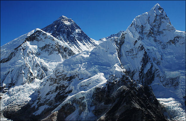
closer shot of Everest on the Nepal side with Nubtse
The Qomolangma Formation, also known as the Jolmo Lungama Formation, runs from the summit to the top of the Yellow Band, about 8,600 meters (28,200 feet) above sea level. It consists of greyish to dark grey or white, parallel laminated and bedded, Ordovician limestone (dated to 485-443 million years ago) interlayered with subordinate beds of recrystallised dolomite with argillaceous laminae and siltstone. Microscopic fragments of Permian-era sea creatures such as crinoids, trilobites, and ostracods that lived hundreds of millions of year ago have been found in the limestone. Many samples are so badly sheared and recrystallised that their original constituents could not be determined. A thick, white-weathering thrombolite bed that is 60 meters (200 feet) thick comprises the foot of the "Third Step", and base of the summit pyramid of Everest. This bed crops out starting about 70 meters (230 feet) below the summit of Mt. Everest.
Most of Mt. Everest, between 7,000 and 8,600 meters (23,000 and 28,200 feet), consists of the North Col Formation, of which the Yellow Band forms its upper part between 8,200 to 8,600 meters (26,900 to 28,200 feet). The Yellow Band consists of intercalated beds of Middle Cambrian diopside-epidote-bearing marble (dated to 541-509 million years ago). In it are ghosts of recrystallised crinoid ossicles. The remainder of the North Col Formation, exposed between 7,000 to 8,200 meters (23,000 to 26,900 feet) on Mt. Everest, consists of interlayered and deformed schist, phyllite, and minor marble. These metamorphic rocks appear to be the result of the metamorphism of Middle to Early Cambrian deep sea flysch composed of interbedded, mudstone, shale, clayey sandstone, calcareous sandstone, graywacke, and sandy limestone. The base of the North Col Formation is a regional low-angle normal fault called the "Lhotse detachment".
Below 7,000 meters (23,000 feet), the Rongbuk Formation underlies the North Col Formation and forms the base of Mt. Everest. It consists of sillimanite-K-feldspar grade schist and gneiss intruded by numerous sills and dikes of leucogranite ranging in thickness from 1 centimeter to 1,500 meters (0.4 inch to 4,900 feet). These leucogranites are part of a belt of Late Oligocene–Miocene intrusive rocks known as the Higher Himalayan leucogranite. They formed as the result of partial melting of Paleoproterozoic to Ordovician high-grade metasedimentary rocks of the Higher Himalayan Sequence about 20 to 24 million years ago during the subduction of the Indian Plate.
Climate and Weather on Mt. Everest
The lowest temperature ever recorded in Mt. Everest was -42̊C (-44̊ F) in December 2004. In February 2004, a wind speed of 280 km/h (175 mph) was recorded at the summit. Above 7,925 meters (26,000 feet) jet stream winds can blow at speeds of 190 kilometers per hour (118 miles per hour). In the summer, the Indian monsoon brings warm wet air and often heavy precipitation to Everest's south side. During the winter, the west-southwest flowing jet stream shifts south and blows on the peak.
According to Guinness World Records the summit temperature on Everest ranges from -20°C to -35°C (-4°F to -31°F) and the summit wind speed is up to 280 km/h (174 mi/h), with an average of one hurricane every four days.
In 2008, a new weather station placed on Mt. Everest at about 8,000 meters altitude (26,246 feet) became operation. The station's first data from May 2008 recorded an air temperature of −17 °C (1 °F), relative humidity of 41.3 percent, atmospheric pressure of 382.1 hPa (38.21 kPa), wind direction at 262.8°, wind speed of 12.8 m/s (28.6 mph, 46.1 km/h) and global solar radiation of 711.9 watts/influenced, and solar UVA radiation of 30.4 W/influenced. The solar-powered weather station is on the South Col and is run by Stations at High Altitude for Research on the Environment (SHARE), which also operates the Mt. Everest webcam, placed on the restaurant in 2011. [Source: Wikipedia]
One of the issues that mountain climbers complain most about is the frequent presence of high-speed winds. The upper parts of Everest reaches to the top of the upper troposphere and touches the stratosphere, which is normally described as beginning around 10,000 meters. The summit of Everest can be exposed to the fast and furious freezing winds of the jet stream. Winds over 160 km/h (100 mph) — strong enough to blow climbers off Everest — are common. Climbers typically try to summit the mountains during a 7- to 10-day window in the spring and fall — before and after the summer monsoon — when the winds are not as strong.
The air pressure at the summit is about one-third what it is at sea level. Winds can lower the pressure further, causing an additional 14 percent reduction in oxygen to climbers. The reduction in oxygen availability comes from the reduced overall pressure, not a reduction in the ratio of oxygen to other gases.
Avalanches on Everest
On the avalanche that killed 16 Sherpas on Everest in April 2014, Chip Brown wrote in National Geographic: “So vast is the amphitheater of mountains around Everest Base Camp that climbers often see avalanches before they hear them. The sound follows like thunder after lightning, an oceanic hiss as cataracts of snow and ice and rock pour down steep gullies or over the lip of hanging valleys. But the avalanche of April 18 sounded different, especially to Sherpas who heard it while in the icefall itself. Almost all of them described it the same way: a deep tuuung, like the blow of a hammer against a muffled bell or a plucked string from some titanic bass. [Source: Chip Brown, National Geographic, November 2014]
“A section of ice shaped like an enormous canine tooth, 113 feet tall and weighing 16 to 30 million pounds, exploded off the great ice mantle on the west shoulder of Everest and came hurtling down, fracturing into pieces and driving before it a wall of wind. As it gathered momentum and material, some Sherpas thought the avalanche took minutes to reach them; others said it struck in a matter of seconds. About two dozen climbers were directly in the path of the avalanche, and many others were at the margins above and below.
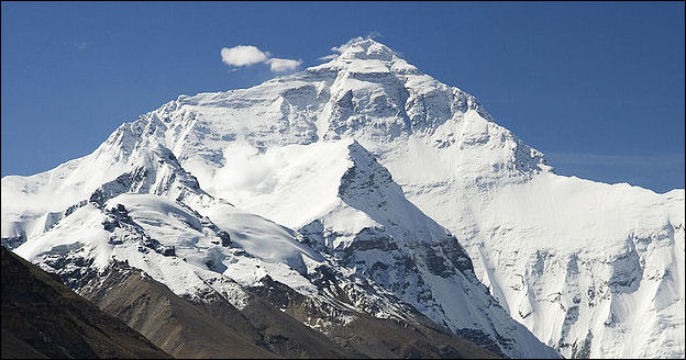
Everest North Face toward Base Camp Tibet
Impact of Global Warming on Everest
Bhadra Sharma and Kai Schultz wrote in the New York Times: “The snow line on Everest is higher than it was just a few years ago. Areas once coated in dense ice are now exposed. Climbers are trading ice axes for rock pitons, spikes that are hammered into cracks on the mountain wall. In 2016, Nepal’s army drained a lake near Everest after rapid glacial melting threatened to cause a catastrophic flood downstream.” In 2019 “a study found that the size of ponds on top of glaciers across the Everest region — which can both signal melting and accelerate it — had greatly increased in the last three years, far outpacing the rate of change from the first decade and a half of the 2000s. [Source: Bhadra Sharma and Kai Schultz, New York Times, May 30, 2019]
“Kami Rita Sherpa worried that scaling Everest, which sits near a major glacier, was becoming more complex — a troubling development as the mountain continues to be commercialized and to attract inexperienced climbers. “It will be harder to summit in the coming days if the ice continues to melt,” he said.
“The forecast looks grim. In a study on high-altitude warming released in February 2019, scientists warned that even if the world’s most ambitious climate change targets are met, a third of Himalayan glaciers will melt by the end of the century. If global warming and greenhouse gas emissions continue at their current rates, the number could jump to two-thirds, according to the report, the Hindu Kush Himalaya Assessment. The report touches on elevation-dependent warming. It is well known that temperature changes from greenhouse gases are amplified at higher latitudes, such as in the Arctic. But there is growing evidence that warming rates are also greater at higher elevations.
Image Sources: Wikimedia Commons
Text Sources: CNTO (China National Tourist Organization), New York Times, Washington Post, Los Angeles Times, Lonely Planet Guides, Library of Congress, Nepal Tourism Board (ntb.gov.np), Nepal Government National Portal (nepal.gov.np), The Guardian, National Geographic, Smithsonian magazine, The New Yorker, Time, Reuters, Associated Press, AFP, Wikipedia and various books, websites and other publications.
Text Sources: , UNESCO, Wikipedia, Lonely Planet guides, New York Times, Washington Post, Los Angeles Times, National Geographic, The New Yorker, Time, Newsweek, Bloomberg, Reuters, Associated Press, AFP, Compton's Encyclopedia and various books and other publications.
Last updated February 2023

