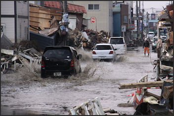
DAMAGE FROM THE EARTHQUAKE AND TSUNAMI OF MARCH 11, 2011
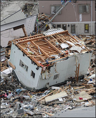
House in Ofunato According to the Japanese National Police Agency in March 2019 a total of 196,559 buildings were destroyed or damaged. More than 460,000 were made homeless and sought refuge in shelters. This included 150,000 in Miyagi Prefecture, 47,000 in Iwate Prefecture and 130,000 in Fukushima Prefecture.
By some estimates the March 2011 earthquake and tsunami was history’s most expensive natural disaster, with losses reaching $310 billion. A total of 1,168,453 buildings were damaged, including 129,107 that were destroyed. Of the destroyed buildings, about 78,000 were completely washed away. Source: Yomiuri Shimbun, August 9, 2011 and Japanese government]
Total damage: ¥17.4 trillion (compared to ¥9.6 trillion for the Kobe earthquake). The Tohoku figure includes 1) ¥10.4 trillion for houses, stores, factories and other buildings; 2) ¥11.3 trillion for electricity, water supplies and other utilities; 3) ¥2.2 trillion for roads, ports and other infrastructure; 4) ¥2.4 trillion for agricultural, fisheries and similar facilites; and 5) ¥1.1 trillion for schools, welfare and similar facilities. A total of 27,149 businesses in three prefectures were damaged. [Source: Japanese government, including the Agriculture, Forestry and Fisheries Agency]
According to the Agriculture, Forestry and Fisheries Ministry, a total of 20,530 hectares of farmland in the three Tohoku prefectures were damaged by the tsunami. As of March 2012, work to desalinate soil had begun in only about 6,870 hectares, or 33 percent, of them. According to the Fisheries Agency, among 260 fishing ports in the three prefectures, 241, or 93 percent, have become able to unload marine products. But shipment at major fish markets as of January was still just 71 percent of that in January last year. Economic losses from the Great East Japan Earthquake are estimated at 16.9 trillion yen, excluding those from the Fukushima nuclear accident. Experts assume that it will cost 2.2 trillion yen to rebuild infrastructure alone. The amount of losses far exceeded the 9.6 trillion yen in damage caused by the Kobe Earthquake.
A survey by the Japanese government showed the percentage of destroyed buildings was markedly higher in areas where the onshore water level surpassed two meters, compared with areas where it was two meters or less. A total of about 535 square kilometers of land was submerged by the tsunami in the six prefectures, the ministry said. About 40 percent of the area was submerged in more than two meters of water. Thirty-four percent of buildings in areas submerged in water between 1.5 and two meters deep were destroyed, but the figure jumped to 72 percent in areas submerged in water between two and 2.5 meters deep.
But at least with the earthquake anyway many were surprised that there wasn't more damage. “Claire Berlinski wrote in the Los Angeles Times: “That so few buildings collapsed in the earthquake was a human triumph of the first order. A minute before the March earthquake, seismic monitoring systems sent warnings to Japanese cellphones. Elevators glided obediently to the nearest floor and opened. Surgeries were halted. Videos from Tokyo show skyscrapers swaying gracefully, like cornstalks in the wind. Not one collapsed. The Japan quake was not the catastrophe it could have been because the country learned from experience. In the wake of the 1995 Kobe quake, in which 200,000 buildings collapsed, Japanese engineers took extensive measures to reinforce buildings and infrastructure. They installed rubber blocks under bridges. They spaced buildings farther apart to prevent domino-style tumbling. They introduced extra bracing, base isolation pads, hydraulic shock absorbers.[Source: Claire Berlinski, Los Angeles Times, July 24, 2011]
Links to Articles in this Website About the 2011 Tsunami and Earthquake: 2011 EAST JAPAN EARTHQUAKE AND TSUNAMI: DEATH TOLL, GEOLOGY Factsanddetails.com/Japan ; ACCOUNTS OF THE 2011 EARTHQUAKE Factsanddetails.com/Japan ; DAMAGE FROM 2011 EARTHQUAKE AND TSUNAMI Factsanddetails.com/Japan ; IWATE PREFECTURE AND THE 2011 TSUNAM factsanddetails.com EYEWITNESS ACCOUNTS AND SURVIVOR STORIES Factsanddetails.com/Japan ; TSUNAMI WIPES OUT MINAMISANRIKU Factsanddetails.com/Japan ; SURVIVORS OF THE 2011 TSUNAMI Factsanddetails.com/Japan ; DEAD AND MISSING FROM THE 2011 TSUNAMI Factsanddetails.com/Japan ; CRISIS AT THE FUKUSHIMA NUCLEAR POWER PLANT Factsanddetails.com/Japan
Good Websites and Sources on Tsunamis: Wikipedia article on Tsunamis Wikipedia ; Surviving a Tsunami, Lessons from Chile, Hawaii and Japan pubs.usgs.gov ; Tsunami Warning System in Japan jma.go.jp/jma ; Tsunami Warnings from Japan Meteorological Agency jma.go.jp/en/tsunami ; Book: “Tsunami: The Underrated Hazard” by Edward Bryant. Tsunamis That Struck Japan Major Tsunamis in Japan in the 20th Century tsunami.civil.tohoku.ac.jp ; Major Earthquakes and Tsunamis in Japan in the 20th Century drgeorgepc.com ; 1933 Earthquake and Tsunami pdf file cidbimena.desastres.hn ; 1983 Tsunami drgeorgepc.com ; Report on the 1993 Tsunami nctr.pmel.noaa.gov ; Small Tsunami in 2010 reuters.com ;
Eyewitness Account of Damage Soon After the Tsunami
Koji Yasuda of the Yomiuri Shimbun Staff flew in plane over the devastated area the day after the earthquake and tsunami. After taking of from Hokkaido he reported: “Devastated areas with collapsed houses and other visible tsunami damage began to appear near Hachinohe Port in Hachinohe, Aomori Prefecture in northern Honshu. “Machines and other equipment lay scattered around factories at the port having been tossed here and there by the surging waters. Floating oil was forming spiral patterns offshore. The plane flew further south. The town of Kuji, Iwate Prefecture, once nestled in the curve of a bay, had been swept away by a tsunami. The ground was soaked in seawater and shining as it reflected the sunlight.” [Source: Koji Yasuda, Yomiuri Shimbun, March 13, 2011]
“The plane entered Miyagi Prefecture. The city of Kesennuma smoldered beneath clouds of white smoke. The fishery town was ravaged by a tsunami during the day and suffered intense blazes at night. As if nothing burnable was left, the tragic area was filled with only rubble. Black smoke also boiled into the sky at Kesennuma, on a part of the coast where heavy oil was flowing from damaged tanks. Inland urban areas were still covered with seawater and white smoke was rising in some places as if the areas had been destroyed by air raids.”
Lots of dramatic video was taken of the earthquake and tsunami as they ravaged affected areas of Japan . A video camera positioned atop Sendai’s airport showed how the tarmac being swallowed by rapids as employees and travelers sought refuge on rooftops. Remarkable video shot by a Japanese news crew as the tsunami struck Sendai, shows their dramatic escape and the rescue of several people who were pulled to safety before the camera.
TV Asahi ANN: and ITN first broadcast jaw-dropping footage of the tsunami sweeping ashore in the fishing port of Miyako, Iwate Prefecture. Several videos appeared that showed the tsunami striking Iwaki City, in Fukushima Prefecture. A powerful video report from Alex Thomson of Britain’s Channel 4 News showed how the tsunami pummeled giant sea walls around a village outside Kamaishi, in Iwate Prefecture.
The nationalist governor of Tokyo, Shintaro Ishihara, said that the quake was an event of “tembatsu” “divine punishment. Ishihara is famous in Japan for saying rash stip things; he apologized the next day.
Damage to Coastal Towns by the 2011 Tsunami
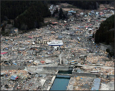
Damage in Wakayu Tens of thousands of homes were destroyed, many roads were made impassable, trains and buses were not running, and power and cell phones remained down. The morning after the quake the JR rail company said that there were three trains missing in parts of two northern prefectures. An oil refinery burned in the city of Chiba. [Source: New York Times]
Japan's National Police Agency said 18,000 houses collapsed and that about 140,000 others were at least partially damaged. By some counts 360,000 were made homeless. More than 270,000 vehicles were damaged by the tsunami in Miyagi, Iwate and Fukushima prefectures. That works out to about 7 percent of all vehicles in those three prefectures. In Miyagi prefecture alone, an estimated 146,000 cars were destroyed.
Dozens of towns and fishing villages and a few small cities along Japan's northeastern coast were battered and deluged by the tsunami . Chico Harlan wrote in the Washington Post, “Towns in Miyagi Prefecture, Iwate Prefecture and Fukushima Prefecture were among the hardest-hit. Video of those areas minutes after the tsunami made landfall gave an initial sense of the ferocity, if not the scope, of the disaster. One sport-utility vehicle was seen wedged between electric poles, pinned down as waves crashed over it. An area that once had been land looked like water. As waves partially submerged the vehicle, a house with a green roof came rushing by, surfing a crest of water. In Natori city, houses were sliced in half — roofs here, living rooms there...Eyewitnesses described entire neighborhoods that have disappeared after being swallowed and chewed up by a massive tsunami wave. Attempts to reach those stranded, trapped or short on supplies were complicated by damage to the roads and rail lines.[Source: Chico Harlan, Washington Post, March 12, 2011]
Todd Pitman of Associated Press wrote; “The scenes of ruin dot the towns and villages along Japan's northeastern coast, devastation not seen here since the U.S. dropped atomic bombs on Hiroshima and Nagasaki during World War II.” The Washington Post reported, “Along the coast between Okawa and Ishinomaki’s central district, the town of Onagawa, population 10,000, had been erased but for a flooded hospital on a hill and the shattered remains of a marine exhibition hall. The tsunami had carried seawater miles inland, to places that couldn’t even see the ocean.”
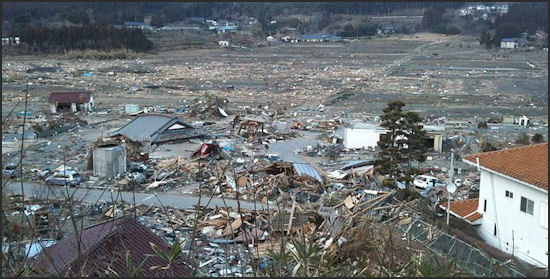
“The coastal town of Rikuzentakata, in Iwate Prefecture,” Harlan wrote, “was entirely submerged by water, according to local authorities. One TV reporter arrived at Iwaki, in Fukushima Prefecture, and reported that the entire town was gone. A hospital in Iwanuma had written “SOS” — in English — on the roof. A derailed train in Miyagi Prefecture, closest to the quake’s epicenter, was seen waylaid against the side of a house. There were no reports on the whereabouts of passengers.”
“Japan’s northeastern coastline, viewed from above, had the look of a dark scar. The fiercest tsunami had sent a wall of water upwards of 20 feet high toward the shoreline, and the wave spread some six miles inland... Some areas, such as Otsuchi town and Sumita town in Iwate Prefecture, sustained such serious damage that nobody has yet been able to get in touch with town officials. In Rikuzentakata city, one of the worst-hit areas, some 5,000 of the town’s 8,000 homes were destroyed...Amid earlier concerns of a nuclear meltdown at one of the Fukushima plants, operated by the Tokyo Electric Power Co., about 40,000 residents were urged to evacuate — just one of many forced migrations across the coast. Tamura city, in Fukushima Prefecture, was asked to receive residents from Okuma town, near the nuclear power plant.”
Shintona was a coastal town close to the epicenter of the earthquake. Describing the destruction there, Jonathan Watts wrote in The Guardian: “The nearby bay is filled with cars, concrete and half-sunken homes uprooted from their foundations. A railway line has been ripped from the ground and twisted vertically like a garden fence. Cars and motorbikes lie broken and so roughly re-parked by the tsunami that some balance precariously on their bonnets. Emergency and media helicopters buzz overhead and the bereaved sob by the side of the road. The air is rich with the rotting smell of disaster and death. [Source: Jonathan Watts, The Guardian, March 13 2011]
While the loss of life and property may yet be considerable, many lives were certainly saved by Japan’s extensive disaster preparedness and strict construction codes. Japan’s economy was spared a more devastating blow because the earthquake hit far from its industrial heartland. Unlike Haiti, where shoddy construction vastly increased the death toll last year, or China, where failure to follow construction codes worsened the death toll in the devastating 2008 Sichuan earthquake, Japan enforces some of the world’s most stringent building codes. [Source: New York Times, March 11, 2011]
Worst Damage to Coastal Towns Where the Water Was Channeled by Inlets and Mountains
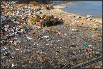
Near Sendai Reporting from Minamisanriku, Martin Fackler and Michael Wines wrote in the New York Times, “Much of the destruction unleashed by the tsunami that struck Japan’s northeastern coast on Friday was captured on television, for all to see. But the most lethal devastation took place in remote fishing communities like this one, where residents said steep mountains and deep inlets amplified the size of the crushing wave, unrecorded by television news helicopters or Internet videos. The only record now is the accounts of the survivors, and as word of what happened here has begun to seep out, even disaster-struck Japan has found itself aghast.[Source: Martin Fackler and Michael Wines, New York Times, March 15, 2011
“Jin Sato, mayor of this quiet fishing port, had just given a speech to the town assembly on the need to strengthen tsunami preparation when the earthquake struck. The tsunami came just over a half-hour later, far exceeding even their worst fears. He and other survivors described a wall of frothing brown water that tore through this town of more than 17,000 so fast that few could escape. Town officials say as many as 10,000 people may have been swallowed by the sea. Even many of those who reached higher ground were not spared by waves that survivors said reached more than 60 feet high.” “It was a scene from hell,” Mr. Sato, 59, said, his eyes red with tears. “It was beyond anything that we could have imagined.”
“In this town, and others nearby, the tsunami created scenes of almost apocalyptic destruction,” Fackler and Wines wrote. “Traumatized survivors have been left to ponder that the living and the dead were separated by the mere caprice of a ravenous, fast-moving wall of water, and sometimes split-second decisions...In Kesennuma, about 16 miles north of here, officials say a six-mile inlet that nurtured the town also proved its undoing, channeling and compressing the tsunami’s power until, at the end, the wave towered nearly 50 feet high...It roared up a river and swamped the new retail district, and it leapt over the harbor wall, veered left and razed whole blocks of the old city center, flinging entire buildings 100 yards and more.
“The scope of the destruction, officials say, far exceeded the worst-case models in experts’ tsunami projections. The wave completely leveled fishing villages and residential enclaves up and down the sound, ravaged the town’s sewage treatment plant and destroyed more than 1.5 miles of shops and apartments on its outskirts.”
Tsunami Damage in Ishinomaki
Flooding and Damage in Ishinomaki
Ishinomaki, a rice-shipping port in Miyagi prefecture founded in the fourth century, was known for its huge fish market, a its manga museum, a replica of the Statue of Liberty on a small island in the Kitakami River and a unique smell made by factories that produced pink fish paste, fermented miso, paper and soy sauce. Home to 162,000 people, it sprawled over wedge of land that included a city and a host of towns and villages,
The disaster hit Ishinomaki — a farming and fishing community of 160,000 about 50 kilometers northeast of Sendai — hard. Of 8,000 people still missing across northeastern Japan, 2,770 are from Ishinomaki; it also has the highest confirmed death toll, 3,100.
Ishinomaki was not only ravaged by the tsunami it was drowned by it. “Nearly a week after the massive earthquake and tsunami hit the city large portions remain underwater, an instant lake clearly visible on NASA satellite photographs,”Mark Magnier wrote Los Angeles Times: “Now, the still-proud statue looks out over legions of logs liberated from a hidden loading dock. Downtown streets, replete with KFC and Coco's Restaurant signs, can best be reached by boat.” [Source: Mark Magnier, Los Angeles Times, March 17, 2011]
“Two-thousand pound cars have punched their way into tractor trailers, through plate-glass windows, up into trees, defying logic as they to rest bumper-to-bumper in seemingly impossible embraces, all a few hundred yards from blocks of untouched Japanese-style strip malls just beyond the high-water mark, stores with names such as "Beauty Shiny," "Hotel Kiss" and "Restaurant Joyfill." Nearby, battered and bruised residents, bracing for the latest aftershock, walk their bicycles on elevated rail lines, the only high-water refuge for many in this flooded The road wasn't designed to end here. But now, the newly formed lake extends into his neighborhood, which abuts the sea, its roads and byways still flooded to neck level.”
Harlan wrote in the Washington Post : “In Ishinomaki and the surrounding towns, one’s fortune is explained by garbage. For thousands who lived closest to the water, their home is a wreck, and the lucky ones — arriving on bikes — pull out a few supplies. For those who lived at higher elevations, where the wall of water reached only waist high, their house can be salvaged, but the damp first-floor contents are piled outside in columns five or six feet high. Women wearing galoshes and track suits drag tatami mats onto their driveways. Young volunteers go house to house, offering help. Possessions pile outside: bookshelves, magazines, stuffed animals, ironing boards, jugs of panko bread crumbs.” [Source: Chico Harlan, Washington Post March 31, 2011]
Tsunami Damage in Shirahama and Shizugawa
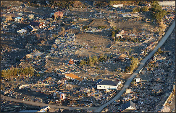
Harlan wrote in the Washington Post: “Shirahama was once a secluded riverfront community, with 40 houses wedged between mountains along the Kitakami River. Fishermen and farmers lived there. Evergreens blanketed hills on both sides, and tunnels connected the town’s main road to destinations east and west. The place to which Yoichi Sato returned had become something far less than a home. Ribbons of exposed insulation and radiant foil hung from two of the walls. The floor was cluttered with children’s books, old receipts and fern branches, all crusted in ocean-floor mud.”
Northern Honshu
“When the quake-triggered tsunami hit March 11,” Harlan wrote, “Sato watched from a hillside as the wave cut his house like a deck of cards. The first floor rolled into the ocean. The second floor carried about 250 feet, sailing over a hill, past a gas station and finally settling at a 20-degree angle atop the concrete foundation of what had once been a Buddhist temple.”
Shizugawa was a small fishing town on Japan's northeastern coast. The massive earthquake and tsunami erased it from the map. More than half the town's 17,000 people are missing. Todd Pitman of Associated Press wrote: “The harbor wall is now half missing. On one road that still exists in Shizugawa, evacuation routes can still be seen painted into the tarmac. One shows a blue wave curled around a running human figure. A green arrow indicates a refuge is just a few hundred yards (meters) away... now covered with debris...Just around the corner, the road is gone, surrounded by an apocalyptic wasteland of knotted rubble that used to be Shizugawa. [Source: Todd Pitman, Associated Press]
Todd Pitman of Associated Press wrote: Shizugawa “had been preparing for just such a disaster since at least 1960, when the largest earthquake on record — a magnitude 9.5 — hit Chile and triggered a tsunami that swept the entire Pacific Ocean and hit Japan. Every year on the anniversary of that destruction — May 22 — residents of Shizugawa practiced tsunami drills — running to designated refuges on higher ground scattered through town as sirens howled and making arrangements for emergency food and shelter.
The drills were voluntary, but most people took part, 50-year-old housewife, Katsuko Takahashi, told AP. "I can't say we prepared enough, because half the population is still missing," she said. "But you cannot prepare for a tsunami this big."
Rikuzentakata
Areas Left Flooded by the Tsunami in 2011
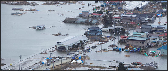
Large swaths of land — mostly in Miyagi Prefecture around Sendai — remained flooded after the tsunami receded. As of late March, 46 percent of Yamamotocho, 38 percent of Wataricho, 34 percent of Iwanuma, 34 percent of Tagajo, 39 percent of Shiogama , 63 percent of Higashi-Matsushima, 46 percent of Ishiomaki and 43 percent of Onagawacho as well as large portions of Sendai and Natori were still under mostly knee- to waist-deep water. Drainage work had started at 33 of them, but 12 areas so far have been left unattended. "This is a disaster much bigger than I'd imagined. I'll start with what I can do," an official from Kagoshima Prefecture sent to help the drainage work in Higashi-Matsushima, told the Yomiuri Shimbun. [Source: Hirokazu Hayashi, Yomiuri Shimbun, March 31, 2011]
Hirokazu Hayashi wrote in the Yomiuri Shimbun: “A two-square-kilometer area in Higashi-Matsushima remains submerged in murky water. A once scenic area...where cherry trees should normally bloom, is engulfed in floodwater now....A road running through the district is submerged when the tide comes in, surfacing again at low tide. Cars and bicycles moved slowly through it, raising sprays of water...No reconstruction can start until the water recedes.”
“Third-year high school student Ryosuke Nakae, 18...Ryosuke has spent a lot of time wading through the dark water that has blurred the boundaries between land and sea. He might find a refrigerator or a deflated soccer ball, but for a long time he came across no clues to his mother's whereabouts or fate. Sometimes, he would stop to look at a spot far away in the sea as if recalling the day the tsunami hit the region. One day, he spotted part of his mother's white car protruding from the dirty water some distance away. However, the floodwater so far has prevented him from approaching it.” "I want to check inside the car," Ryosuke said. "If there wasn't water here..." He bit his lower lip.
“Shichigahamamachi, which faces Matsushima Bay, has four areas still underwater because a coastal levee keeps the floodwater from draining back into the bay. A pumper truck has started to remove water in just one of the areas. “"There might be some bodies still left under the water," an official of the town office's antidisaster headquarters said. "But we can't search for them without draining the water. Restoration of roads and electricity will be possible only after those areas are drained."
Flooding in Minato
Soiled Money and Lost Family Registries and Medical Records
All the family registry data for Minami-Sanrikucho, Miyagi Prefecture, appears to have been lost in the tsunami that struck the town. The town had computerized its family registry data, but its government building was completely destroyed in the disaster. As no system existed to share data with other legal affairs bureaus or local authorities, it is highly likely Minami-Sanrikucho's data has been irrevocably lost. This is believed to be the only case in which data has been destroyed at both a local government and a legal affairs bureau as a result of the March 11 earthquake. The data also had been kept at the Sendai Legal Affairs Bureau's Kesennuma branch in Kesennuma, Miyagi Prefecture, but its system was submerged in the tsunami as well. [Source: Yomiuri Shimbun, March 23, 2011]
The Justice Ministry intends to ask the town to recreate the registries, as required by the Family Registration Law, but this is expected to be extremely difficult. The loss also is expected to spur debate on revamping the family registration system, including the possibility of creating a national network. People who have their legal domicile in Minami-Sanrikucho now have no means of verifying their family registry. A complete copy or an extract of a family register is usually required for inheritance purposes, such as gaining access to a deceased person's bank accounts.
Lost medical records have also been a problem. The Yomiuri Shimbun reported: “At least 14 hospitals in Iwate and Miyagi prefectures lost their medical records in the March 11 tsunami... according to a Yomiuri Shimbun survey, making it difficult to verify patients' medical histories and courses of medication. Numerous records were washed away or rendered illegible by the water, the survey found. However, Ishinomaki Municipal Hospital in Miyagi Prefecture suffered minimal losses because it had digitized its data and kept backup copies at a hospital in Yamagata.”
In late June the Yomiuri Shimbun reported: “More than 2.4 billion yen in bills and coins soiled or damaged by the March 11 tsunami has been brought to Bank of Japan branches in the hard-hit Tohoku region to be replaced. This figure is triple the 800 million yen exchanged for undamaged currency in the six months after the 1995 Kobe Earthquake--an indication of the sheer extent of the damage wrought by the March 11 disaster. As of June 28, 320,000 damaged banknotes and 930,000 coins had been brought to Bank of Japan branches in Sendai, Fukushima, Aomori and Akita, and a temporary branch set up in Morioka.
Image Sources: 1) U.S. Navy except Rikuzentakata posted on Flickr and WikiCommons by Akira Kouchiyama Flickr and Natori photos by NASA
Text Sources: New York Times, Washington Post, Los Angeles Times, Times of London, Yomiuri Shimbun, The Guardian, National Geographic, The New Yorker, Time, Newsweek, Reuters, AP, Lonely Planet Guides, Compton’s Encyclopedia and various books and other publications.
Last updated August 2020

