GLACIER ICE FEATURES
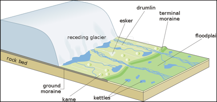
main features left behind after a glacier recedes The main features of a glacier, particularly Alpine glaciers are 1) crevasses, large cracks that occur in glaciers; 2) icefalls, areas where the glacier is moving relatively quickly and breaking apart, producing large areas of crevasses and jagged ice; and 3) moraines, walls of debris that mark the edge of major Alpine glacier tongues. When the ice melts at the bottom of a glaciers rock and soil are deposited. Over time large amounts of this debris accumulate into moraines. The bottoms of glaciers are riddled with caves and tunnels carved out by meltwater. There are tight squeezes and well as huge galleries.
Ice Falls in a glacier are like water falls in a river. They form in steep sections of the glacier and are characterized fast flow that can cause the ice to break into seracs. At these falls, flow is extremely fast, and the ice stretches and thins, often breaking apart to form blocks called seracs. Ice cover may not be continuous in these areas — there even may be sections where bare bedrock is exposed.
Seracs are blocks of ice that have detached from the main glacier. They are the pinnacles of ice formed where the glacier surface is torn by sets of crevasses. Seracs often detach from the glacier in sections of steep ice (see ice falls). At ice fall base, compression and thickening of the ice often reincorporates seracs into continuous glacier ice. Seracs can also form by a process called dry calving at the glacier terminus. In this case, they melt in place. If they are covered in debris after breaking off, they can form depressions called kettles that sometimes fill with water. The flow of the ice down a steep gradient often results in crevasses and seracs.
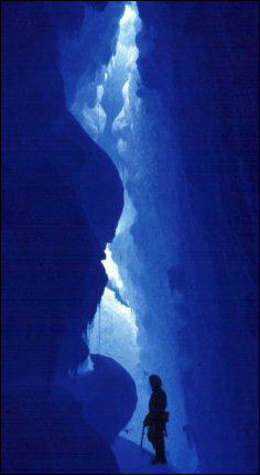
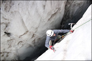
Ice Caves are formed in or under a glacier, typically by running water. Steam or high heat flow can also form glacier caves. Melting at the margin of a glacier may cause small caves to form within the ice, between the ice and the bedrock, or between the ice and the sediment beneath it. Ice caves can also form where water exits from beneath the glacier or where the ice flows over a large bump its bed. Glacier ice caves are cold, with icy water dripping from their roofs. Sometimes, rocks and debris that the glacier has picked up melt out and drop into the caves. People interested in exploring ice caves should wear helmets, as they would in other kinds of caves. Glacier Ice Caves are sometimes referred to as "ice caves", but the term ice caves is more commonly used for caves in rock which contain ice year-round. They are also called Glacier Caves.
Icebergs are also blocks of ice that have detached from the main glacier. Icebergs form when glacier ice breaks off into a water body — a process known as “calving.” Calving refers to large pieces of ice falling off the end of glaciers. This is usually associated with glaciers that terminate in bodies of water, which causes the ice to melt and fracture more quickly. After a calved piece of ice falls into the water it becomes an iceberg. Those in the ocean are not made from sea ice but instead are chunks of glacier ice that formed on land. You can also find icebergs in lakes.
Ogives are arc-shaped features occasionally found across the glacier surface below icefalls. They may be ridges and swales in the ice or bands of darker or lighter ice. One theory of their formation suggests that the ice is stretched and sometimes dirtied when exposed in the icefall during the high velocities of summer; it is compressed during the winter so that bands of different ice thickness form.
See Separate Articles: GLACIERS: TYPES, MECHANICS, DANGERS factsanddetails.com ; MOUNTAINS: TYPES, GEOLOGICAL FEATURES AND MEASURING THEM factsanddetails.com; AVALANCHES factsanddetails.com; MOUNTAIN GLACIERS AND GLOBAL WARMING factsanddetails.com TIBET, THE HIMALAYAS, MELTING GLACIERS AND GLOBAL WARMING factsanddetails.com
Crevasses
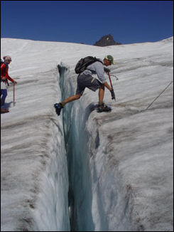
crevasse Crevasses are cracks that form in glacier ice when the glacier is put under too much stress for it to deform by flowing or creeping . This can happen when: 1) The ice stretches too fast and is pulled apart, for example if the ice speeds up as it flows down the valley; 2) Faster-moving ice crunches up against slower-moving ice, for example, when the glacier moves over a bump or step in its rocky bed. [Source: U.S. National Park Service]
Crevasses form where the speed of the ice is variable, such as in icefalls and at valley bends. The surface may appear blistered with crevasses where the ice flows over bedrock knobs and ridges. Crevasses are a glacier's most awesome features and are a constant hazard for climbers. They form where adjacent parts of a glacier are moving at different speeds. This unequal rate of flow produces stresses in the ice that cause it to break. Groups of crevasses often form where the glacier flows over a steep place in its bed. The ice moves faster here, and pulls apart, and a crevasse is formed. Although a large crevasse may seem to be bottomless to the observer, most crevasses are less than 100 feet deep because ice pressure tends to close the open spaces in the ice below that depth.
One type of crevasse forms when a glacier flow speeds up too fast for the ice to compensate by flowing. Think about stretching silly putty or bread dough or any other thick, stretch substance. When it is pulled apart slowly, putty will stretch and deform; when it is yanked apart suddenly, it will break. This is similar to how this type of crevasse forms, when a glacier is flowing too fast for the ice to deform. A second type of crevasse forms when the ice piles up on itself, crunching and cracking. These crevasses form like faults in the Earth's crust, with blocks of ice moving past one another along a crack. They can occur when the ice flows over a bump or step in the bed, rounds a bend, or slows down near its terminus.
Glacial Sediments and Rocks
Glacial till and glacial flour are sediments produced through glacial grinding that are very distinctive. Glacial till contains sediments of every size, from tiny particles smaller than a grain of sand to large boulders, all jumbled together. Glacial flour is that smallest size of sediment (much smaller than sand) and is responsible for the milky, colored water in the rivers, streams, and lakes that are fed by glaciers. [Source: U.S. National Park Service]
Glacial till is the sediment deposited by a glacier. It is an unsorted, unstratified mixture of fine and coarse rock debris deposited by a glacier. It is deposited directly by the glacier without the extreme reworking by meltwater. As glaciers melt, their remaining load of rocks is distributed in several ways. Rocks may be dropped in place by the melting ice; they may be rolled to the ice margins, or they may be deposited by meltwater streams. Collectively, these deposits are called "glacial drift". "Till" refers to the debris deposited directly by the glacier. Rock debris rolls off the glacier edges and builds piles of loose unconsolidated rocks called "glacier moraine".
Glacial Till blankets glacier forefields. It can be mounded to form moraines and other glacier landforms, and is ubiquitous in glacial environments. It has a very distinctive composition that arises from the fact that glaciers not only grind rocks, breaking them into small, fine pieces but also they also pluck off large chunks of rock. This means that glaciers transport everything from large boulders to tiny grains smaller than sand. These rocks and sediments are all mixed together in a jumble after they are deposited. In contrast, rocks and sediments deposited by rivers settle out as the water speed slows, so big boulders are often dropped before small grains of sand. Rather than jumbling sediments of every size, rivers sort them out in a way that viscous glaciers cannot.
crevasse
Glacier Flour describes the component of glacier sediment that is much finer than sand. This material has a similar consistency to flour, which is the reason for its name. Because this sediment is so fine, it is easily transported by and suspended in water. It is responsible for the cloudy or milky appearance of the streams, rivers, and lakes that are fed by glaciers. Glacier lakes can have a wide range of beautiful colors that arise as sunlight scatters when it hits sediment particles in the water. Also called Rock Flour or Glacier Milk.
Glacial flour is the fine-grained sediment carried by glacial rivers that results from the abrasion of rock at the glacier bed. Its presence turns lake water aqua blue or brown, depending on its parent rock type. Rivers originating beneath glaciers are choked with glacial flour, the silty fine-grained sediment produced by the abrasion of rocks at the glacier bed. Fine-grained, silt-size sediment formed by the mechanical erosion of bedrock at the base and sides of a glacier by moving ice. When it enters a stream, it turns the stream's color brown, gray, iridescent blue-green, or milky white.
Glacial Erratics are rocks of unspecified shape and size, transported a significant distance from its origin by a glacier and deposited by melting of the ice. Erratics range from pebble-size to larger than a house and usually are of a different composition that the bedrock or sediment on which they are deposited. Glaciers can pick up chunks of rocks and transport them over long distances. When they drop these rocks, they are often far from their origin — the outcrop or bedrock from which they were plucked. These rocks are known as glacial erratics. Erratics record the story of a glacier's travels. Looking for the bedrock units that correspond with erratics can reveal complex flow patterns.
Glacial drift is the loose and unsorted rock debris distributed by glaciers and glacial meltwaters. As glaciers melt, their remaining load of rocks is distributed in several ways. Rocks may be dropped in place by the melting ice; they may be rolled to the ice margins, or they may be deposited by meltwater streams. Collectively, these deposits are called "glacial drift". "Till" refers to the debris deposited directly by the glacier. Rock debris rolls off the glacier edges and builds piles of loose unconsolidated rocks called "glacier moraine". "Lateral moraines" form along the side of a glacier and curl into a "terminal moraine" at the glacier's downvalley end. Drift and moraines are valuable to geologists because they outline the boundaries of past glaciations.
Glacial polish is the leveling and smoothing of rock by fine-grained debris at the glacier bed. Glacier ice alone is too soft to be a powerful rock-cutting agent. Many glaciers are armed with rock fragments embedded within the ice that are effective cutting tools. The rock-choked ice grazes over the glacier bed, removign rock obstacles and leaving the bedrock rounded and smoothed. In some places fine-grained debris polishes the bedrock to a lustrous surface finish called glacial polish. Coarser rocks may gouge scratches called striations.
Moraines
Glacier moraine: As glaciers melt, their remaining load of rocks is distributed in several ways. Rocks may be dropped in place by the melting ice; they may be rolled to the ice margins, or they may be deposited by meltwater streams. Collectively, these deposits are called "glacial drift". "Till" refers to the debris deposited directly by the glacier. Rock debris rolls off the glacier edges and builds piles of loose unconsolidated rocks called "glacier moraine". "Lateral moraines" form along the side of a glacier and curl into a "terminal moraine" at the glacier's downvalley end. Drift and moraines are valuable to geologists because they outline the boundaries of past glaciations.
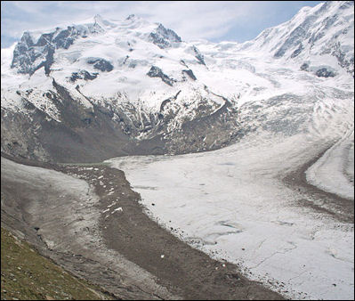
Gorner Glacier Lateral moraines are piles of loose unsorted rocks along the side margins of the glacier. The rocks may be pushed there by the moving ice or dumped from the glacier's rounded surface. As glaciers melt, their remaining load of rocks is distributed in several ways. Rocks may be dropped in place by the melting ice; they may be rolled to the ice margins, or they may be deposited by meltwater streams. Collectively, these deposits are called "glacial drift". "Till" refers to the debris deposited directly by the glacier. Rock debris rolls off the glacier edges and builds piles of loose unconsolidated rocks called "glacier moraine". "Lateral moraines" form along the side of a glacier and curl into a "terminal moraine" at the glacier's downvalley end. Drift and moraines are valuable to geologists because they outline the boundaries of past glaciations.
Lateral Moraines are sharp-crested piles of glacially-transported rocks and debris that are dropped by the ice as it melts. They form only in the ablation zone of a glacier (where more ice is melting than is accumulating as snow each year). This makes them good indicators of where the line between the accumulation zone and the ablation zone — the equilibrium line — occurred on past glaciers. They often remain on the landscape long after glacier retreat and are frequently contiguous with terminal moraines. Lateral and medial moraines consist of glacially-transported rock and debris. They form on the sides of glaciers (lateral moraines) or at the boundary between two tributary glaciers (medial moraines). Either way, they often mark the edges of an ice body. [Source: U.S. National Park Service]
Medial moraines form where two tributary glaciers come together or two mountain glaciers bearing lateral moraines unite. They appear as dark streaks of rock along the glacier centerline. They are generally surficial features on the ice and often consist of rock that has fallen from a rockwall where the glaciers converge. Because they are thin, surficial features, medial moraines are rarely preserved after the ice retreats.
Terminal and Recessional Moraines mark the farthest reaches of a glacier — its terminus — at a given point in time. They are usually built from rocks and debris that are transported to the glacier toe in the ice and melt out there. If the glacier terminus stays in one position for a long time, more debris will accumulate there, building a larger moraine. As long as the glacier does not readvance, the moraine can be preserved for thousands of years! If, on the other hand, a glacier retreats more quickly, and its terminal position changes every few years, it may leave a series of smaller recessional moraines, rather than a large terminal moraine. Sometimes, such moraines dams water melting off the ice today, creating picturesque turquoise lakes.
Terminal moraines are piles of loose unconsolidated rock at the glacier's downvalley end. The rocks may be pushed there by the forward motion of the glacier or dumped from the glacier's rounded surface. As glaciers melt, their remaining load of rocks is distributed in several ways. Rocks may be dropped in place by the melting ice; they may be rolled to the ice margins, or they may be deposited by meltwater streams. Collectively, these deposits are called "glacial drift". "Till" refers to the debris deposited directly by the glacier. Rock debris rolls off the glacier edges and builds piles of loose unconsolidated rocks called "glacier moraine". "Lateral moraines" form along the side of a glacier and curl into a "terminal moraine" at the glacier's downvalley end. Drift and moraines are valuable to geologists because they outline the boundaries of past glaciations.
Terminus: is the downvalley end of a glacier. It is sometimes referred to as the glacier snout. The lower-most margin, end, or extremity of a glacier. Also called Toe, End or Snout.
Glacial Landforms
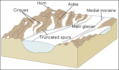
Glacial landscape
Glaciers are moving bodies of ice that can change entire landscapes. They sculpt mountains, carve valleys, and move vast quantities of rock and sediment. In the past, glaciers have covered more than one third of Earth's surface, and they continue to flow and to shape features in many places. Past glaciers have created a variety of landforms such as distinctive, steep-walled, flat-bottomed valleys. U-shaped valleys, fjords, and hanging valleys are examples of the kinds of valleys glaciers can erode. Glaciers and the landscapes they have shaped provide invaluable information about past climates and offer keys to understanding climate change today. [Source: U.S. National Park Service]
U-Shaped Valleys are carved by valley glaciers. They differ from V-shaped valleys carved by rivers. During periods when Earth’s climate cools, glaciers form and begin to flow downslope. Often, they take the easiest path, occupying the low V-shaped valleys once carved by rivers. As glaciers flow through these valleys, they concentrate erosive action over the entire valley, widening its floor and over-steepening its walls. After the glacier retreats, it leaves behind a flat-bottomed, steep-walled U-shaped valley.
Fjords are narrow inlets that reach into the ocean, typically carved by valley glaciers. They over-steepen the walls around them, as they do when carving u-shaped valleys. Thus, fjords have tall, steep walls like glacial valleys, but their floors are below sea level and thus are inundated with ocean water.
Nunataks are rocky islands that are surrounded by flowing glacier ice. As the glaciers surrounding a nunatak come together, a medial moraine composed of rockfall from the nunatak often marks their confluence. Nunataks, arêtes, and horns are the result of glacial erosion in areas where multiple glaciers flow in multiple directions. When the ice is present, they form stark, rocky outcrops above it, adding to the beauty of these harsh landscapes. Once the ice retreats, these uniquely-shaped features provide clear evidence of past glacier flow
Roche moutonnees: are small asymetrically-shaped hills formed by glacial erosion. The upper sides are rounded and smoothed and the lower sides are rough and broken due to quarrying by the glacier. Bedrock knobs are commonly polished on their upper side and are quarried and broken on the lower. These rounded knobs are formed in all sizes. Observers of the 1700s thought they resembled fashionable wavy wigs of their day and named the rouches moutonnees.
Glacial Landscape Features
Glacial Striations are scratches gouged out into the rock at the bed of a glacier by coarse rocks carried by a glacier. As glaciers flow over land, they incorporate pieces of rock and sediment into the ice. These inclusions make the glacier sole (the bottom of the glacier) into a kind of coarse sandpaper that is capable of scratching bedrock. Over time, the glacier moves over rock and sediment, leaving striations or striae, on the rock surfaces that can reveal the direction that the glacier was flowing. Striations indicate grinding of sand and rock particles into the bed under considerable pressure. Glacier ice alone is too soft to be a powerful rock-cutting agent. Many glaciers are armed with rock fragments embedded within the ice that are effective cutting tools. The rock-choked ice grazes over the glacier bed, removing rock obstacles and leaving the bedrock rounded and smoothed. In some places fine-grained debris polishes the bedrock to a lustrous surface finish called glacial polish. Coarser rocks may gouge scratches — striations. [Source: U.S. National Park Service]
Glacier scientists often use striations to determine the direction that the glacier was flowing, and in places where the glacier flowed in different directions over time, they can tease out this complex flow history by looking at the layered striations. Thus, glacier striae are an important tool for people looking to reconstruct past glaciers. As the glacier passes over a surface over longer and longer periods of time, it smoothes it much like sandpaper does. This smooth rock surface often has striations imprinted on it as well, and the entire thing is known as "glacier polish."
Drumlins are hills of sediment (generally a quarter of a mile or more in length) that have been streamlined by glacier flow. Thus, they are often elongated. They often occur together in fields, some with as many as several thousand individuals. The classic drumlin shapes is a hill that highest on its up-glacier end and tapers gently from there, like a half-buried egg. Not all drumlins taper like this, though. Because they have been streamlined by flowing ice, scientists often use them to understand past glacier flow directions. They are longest in the direction of flow.
Outwash Plains occur in front of melting glaciers. They are expansive, generally flat areas that are dominated by braided rivers when the glacier is actively melting. In areas that were once glaciated, old outwash plains can be found by looking for glacial sediment (till) that has been sorted by grain or boulder size as it is picked up and deposited by flowing water. This means that the sediment is typically finest farthest away from the glacier. Outwash plains can extend for miles beyond the glacier margin.
Eskers are meandering ridges of sediment that form in water channels beneath or within the glacier ice. The floors of these channels can be rock, sediment, or ice. As water speeds in the channels slow (during retreat or during periods of low melt), it drops the sediment it carries and builds small piles that take on the shape of the channels.
Outwash plains and eskers form due to the flow of meltwater in front of (outwash plains) or beneath (eskers) that glacier ice. They are composed of glacial sediments that have been reworked by flowing water. The outwash plains in front of many glaciers ends far away from the glacier and are characterized by braided rivers and small ponds.
Alpine Glacier Geological Features
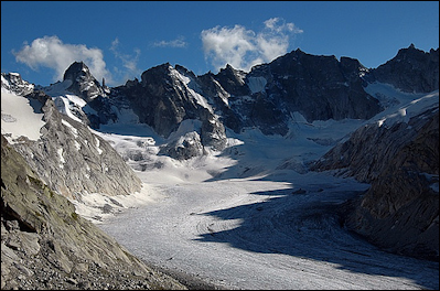
Forno glacier in the Alps A typical Alpine glacier resembles a hand. The palm is the main part of the glacier and where snow is accumulating and turning into ice. The fingers, sometimes called tongues or snouts, are rivers of ice that flow down various valleys and out of the mountains. Tributary glaciers are similar to the streams that feed a river. They are created in reaches of the mountains, where they scrape off rock and pick up gravel and carry them with into the main glacier, resulting in the twisting, parallel black lines that you often see in large glaciers.
Alpine glacier features include: 1) U-shaped valleys, mountain valleys that have been carved out by glaciers; 2) hanging valleys, U-shaped valleys that chopped off by a glacier going another direction, leaving a valley with a big cliff at its widest and lowest point (spectacular waterfalls often form here); 3) cirques, bowl-like basins formed by glacial erosion; 4) cols, jagged glacier-carved peaks. A valley with a parabolic or "U" shaped cross-section, steep walls and generally a broad and flat floor. Formed by glacier erosion, a U-shaped valley results when a glacier widens and over-steepens a V-shaped stream valley. 5) A tarn is A lake that develops in the basin of a cirque, generally after the melting of the glacier (See Glacial Lakes).
Glacier pick up and carry massive amounts of rock and soils. These and the ice itself can wear away the hardest rocks and scour the landscape under and beside a glacier, creating a geological features associated with glaciers. Glaciers act like dams that store water in the winter and release it the summer when farmers most need it. But if too much water is releases, such as during a spring heavy rain, when spring melting is at peak, flood can occur. Sometimes lakes created within glaciers burst their dams and cause catastrophic flooding. When a glacier retreats, the land is occupied by a succession of plants, beginning with lichens, grasses and flowering plants. As they produce detritus that fertilizes the soil, mat-forming trees such as willows appear. Within about 50 years, thickets of alder trees have established themselves. A mature forest generally takes about 200 to 250 years to establish itself after a glacier is gone.
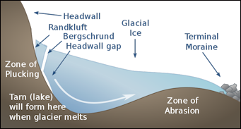
Cirque formation Cirques are deep, steep-walled recess in a mountain, caused by glacial erosion. They are typically bowl-shaped, amphitheater-like depressions that glaciers carve into mountains and valley sidewalls at high elevations. Often, the glaciers flow up and over the lip of the cirque as gravity drives them downslope. Lakes (called tarns) often occupy these depressions once the glaciers retreat. How can glaciers flow uphill? Glacier ice always flows downslope, but the slope that dictates ice flow direction is not that of the rock or sediment beneath the glacier. Rather, ice flow direction is determined by the glacier surface: a glacier will always flow in the direction the ice is sloping. This means a glacier can flow up hills beneath the ice as long as the ice surface is still sloping downward. Because of this, glaciers are able to flow out of bowl-like cirques and overdeepenings in the landscape. Learn more about glacier motion here.
Hanging Valleys are U-shaped valley carved by a glacier that reaches a cliff created by a much biiger glacier. A small mountain glacier may join a larger valley glacier, just as a stream may join a larger river. The smaller glacier, however, may not be as deep as the main one, and its base may be higher in elevation than the main glacier's base. When the glaciers retreat from the area where they formerly met, the floor of the u-shaped valley formed by the smaller glacier may be many feet above the main valley. Waterfalls often form at this point when rivers begin flow through the glacier valleys. [Source: U.S. National Park Service]
Arêtes are a thin, jagged crests that separate — or that once separated — two adjacent glaciers. These rugged ridgelines often look like serrated knives or saw blades, with steep sides and a sharp crest. The low points on the serated surface are known as cols. Cols act as spillways for the ice and occur where glacier action has eroded the rock sufficiently to overtop it.
Horns are pointed peaks that are bounded on at least three sides by glaciers. They typically have flat faces that give them a somewhat pyramidal shape and sharp, distinct edges. The Matterhorn is perhaps the most famous example of this kind of peak.
Glacial Lakes
Paternoster Lakes occur in a series down a formerly glaciated valley in small basins scooped out by the glacier as it retreated. The name suggests a similarity to beads on a rosary, and the lakes are often connected to one another by streams that run between them and down the valley. [Source: U.S. National Park Service]
Kettles form when a block of stagnant ice (a serac) detaches from the glacier. Eventually, it becomes wholly or partially buried in sediment and slowly melts, leaving behind a pit. In many cases, water begins fills the depression and forms a pond or lake — a kettle. Kettles can be feet or miles long, but they are usually shallow. As a glacier recedes, sediment is washed out from the glacier and deposited in a flat area below, forming an outwash plain. Kettles pockmark these outwash plains and other areas with glacial deposits.
Tarns are lakes that form in glacially-carved cirques. They are often dammed by moraines. If they are still associated with moving glaciers, tarns are often full of tiny, glacially-ground sediment that scatter light and can make the water appear colorful. Thus, the color of a glacier's tarn is a good way to diagnose whether or not the ice is still actively moving (crevasses on the glacier surface are another good indication of glacier movement).
Glacier Mice

Glacier Mice
Nicholas Midgley and Stephen Coulson wrote in The Conversation: “Glaciers are commonly considered to be cold and barren places that are hostile to life. Plants cannot grow directly on these slowly flowing bodies of ice, but life can be found here nonetheless, and perhaps none of it stranger than the glacier mice. You might be imagining a small rodent that has evolved an especially thick coat to withstand the cold. But glacier mice are actually balls of moss, each about the size of a tennis ball, and typically shaped into slightly squashed spheres that amass around pebbles on the surfaces of some glaciers. Where you find one glacier mouse, you tend to find a whole group of them. If you’re struggling to imagine one, they look a bit like tribbles, from the famous Star Trek episode, or the rolling trolls from Frozen. [Source: Nicholas Midgley, Lecturer in Physical Geography, Nottingham Trent University and Stephen Coulson, Project Manager, Swedish University of Agricultural Sciences, The Conversation, June 8, 2020]
“Glacier mice were first documented by a researcher called Jón Eythórsson in 1951, who gave them their strange name (“jökla-mýs” in Icelandic). But it would be over 50 years before scientists properly studied them, and there was a lot that initially baffled them. How did these plants grow on the icy surface without perishing? How did they manage to form balls, with growing moss on all sides? And, strangest of all, how did they manage to move, around 2.5cm each day, with choreographed, herd-like behaviour?
“Glacier mice don’t appear on just any ice sheet – there are only a few glaciers worldwide where they can be found. In 2012, we travelled to one called Falljökull to study their movements. We dissected some of these moss balls and inserted accelerometers. These devices measure movement, and are used to orient mobile phones so that if you rotate them, their displays turns accordingly. The data we collected from accelerometers helped crack the puzzle of how moss in contact with the ice can survive when other plants would usually die. The glacier mice rotated often, at least once every few days. It is this rotation that enables the glacier mice to grow moss around the whole of their outer surfaces – sometimes creating near perfect spheres. If the glacier mice stopped rotating, the moss that comes into permanent contact with the glacier surface would die.
“Glacier mice are often found teetering on icy pedestals, and that’s because each of these moss balls actually reduces the amount of melting that occurs underneath it. So over a period of hours and days, the glacier mouse becomes elevated on a pedestal of ice and it eventually rolls off. This process repeats itself over and over, so that the ball exposes a different surface to the sun each time it falls. In time, this means the moss ball rotates often and evenly enough to prevent any part staying in contact with the ice too long.
“Recent research on glacier mice in Alaska found that glacier mice can live for more than six years in this pattern. But scientists still don’t know why groups of glacier mice tend to move herd-like on the ice surface, sometimes south, sometimes west, but always in concert with each other. Wind, gravity and melting patterns aren’t enough to fully explain the mystery, so research continues.
“Globally, glacier mice are rare. But where they are found – in places such Alaska, Svalbard and Iceland – they tend to be abundant, with dense groups of mice sometimes forming on areas of the glacier. Despite living in one of the coldest environments on Earth, we found that the temperatures inside glacier mice are relatively warm. Over a two-week period in July and August, the internal temperature of the glacier mice reached a maximum of 14.7°C, much higher than the ice surface, which is close to 0°C. This warmth amid so much frigid cold provides a unique ecosystem for other life, such as microscopic animals that we were surprised to discover living on a glacier. These included springtails (small insect-like animals), water bears (also known as tardigrades, the only animals known to have survived in space) and roundworms.
Image Sources: Wikimedia Commons, United States Geological Survey (USGS), NASA, Purdue University
Text Sources: United States Geological Survey (USGS), U.S. National Park Service, New York Times, Washington Post, Los Angeles Times, Times of London, Yomiuri Shimbun, The Guardian, National Geographic, The New Yorker, Time, Newsweek, Reuters, AP, Lonely Planet Guides, Compton’s Encyclopedia and various books and other publications.
Last updated April 2022
