GEOGRAPHY OF JAPAN

With the Pacific Ocean to the east, the Sea of Japan to the west and the East China Sea to the south, Japan is an archipelago comprised of four major island and 6,800 smaller islands. Covering about 145,856 square miles (378,000 square kilometers), Japan is slightly larger than the United Kingdom, slightly smaller than California, approximately the same size as Germany, Finland, Vietnam, or Malaysia, and one twenty-fifth the size of the United States. The nearest countries are Korea (about 100 miles to the west), Russia and China. Japan is divided into state-like 47 prefectures.
The islands of Japan make up less than 15 percent of Japan’s total territory. Most of its territory is in the sea. In addition to the 200 nautical miles (370 kilometers) of ocean that Japan can also claims around the main islands according to the 1982 United Nations Convention of the Law of the Sea it can also claim 200 nautical miles around far flung Japanese islands that extend from near Taiwan and China to far out in the Pacific Ocean.
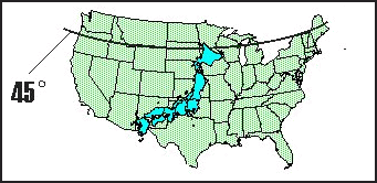
In terms of latitude, Japan coincides approximately with the Mediterranean Sea and with the city of Los Angeles in North America. Paris and London have latitudes somewhat to the north of the northern tip of Hokkaido. About 12.7 percent of the country is good for agriculture (compared to 21 percent in the U.S.) and most of this arable land is along the coast or in the river valleys between the mountains on the main islands. Mountains ranges and volcanos (some still very active) cover about 68 percent of Japan. Large plains around Tokyo and Osaka that once contained a lot of farm land are now heavily urbanized. Only 1.7 percent of Japan is covered by pastures and grasslands.
Websites and Resources
Links in this Website: LAND AND GEOGRAPHY OF JAPAN Factsanddetails.com/Japan ; CLIMATE AND WEATHER IN JAPAN Factsanddetails.com/Japan ; STORMS, FLOODS AND SNOW IN JAPAN Factsanddetails.com/Japan ; TYPHOONS Factsanddetails.com/Japan ; TYPHOONS IN JAPAN Factsanddetails.com/Japan ; NATURAL RESOURCES AND JAPAN Factsanddetails.com/Japan
Good Websites and Sources: Geography of Japan afe.easia.columbia.edu/japan ; Statistical Handbook of Japan Land and Weather Chapter stat.go.jp/english/data/handbook ;2010 Edition stat.go.jp/english/data/nenkan ; News stat.go.jp ; Japan’s Ministry of Environment env.go.jp/en ; Essay on Use of the Term Orient aboutjapan.japansociety.org ; Essay on Comparing Japan and Britain on Environmental Criteria aboutjapan.japansociety.org ; Wikipedia article on Geography of Japan Wikipedia ;
Maps Statistical Maps of Japan stat.go.jp ; Library of Congress Map Collection (do a Search for Japan ) http://lcweb2.loc.gov/ammem ; Japanese Historical Maps from Berkeley davidrumsey.com/japan ; Japan Map Center jmc.or.jp/english ; Geographical Survey Institute, Government of Japan gsi.go.jp ; JNTO JNTO No. 2 ; Lonely Planet Lonely Planet ; Perry-Castaneda Mapp Collection University of Texas ; National Geographic Map Machine: National Geographic ; Maps.com Maps.com ; Google Maps Google Maps
Land and Landscape of Japan
Most Japanese live in the sprawling urban areas that seem to go on forever, but once they end they give way to beautiful countryside. Forests cover about two-thirds of Japan. About 41 percent of the trees in the forests have been planted in nice neat rows, and 44 percent of the planted tree are cedars. The heavily indented coastline extends for 16,654 miles.
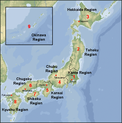
The less developed side of Japan that faces the Sea of Japan is often referred as the “backside of Japan” as opposed to more developed “front side” that faces the Pacific. East Japan refers mainly to the Tokyo-Yokohama, Mount Fuji, Japan Alps area. West Japan refers to everything south of Kyoto and Osaka on Honshu, plus the northern part of Kyushu. The area around Tokyo is called Kanto (a reference to Kanto Plain which Tokyo is part of); the region that embraces Osaka, Kyoto and Kobe is called Kansai (or Kinki). Tohuko describes northern Honshu.
The Japanese countryside landscape, sometimes called the satoyama, is structured like a fine patchwork quilt or tile mosaic. An amazing variety of land-use patterns are jumbled together in a complicated manner. The individual patches are all small in area, and often isolated from others of their kind. Each type of land-use pattern contains its own distinctive set of tree species. The result is that a wide diversity of trees, shrubs and woody vines can be found within a very limited area. [Source: Kevin Short, Daily Yomiuri, October 5, 2011]
Paul Theroux wrote in The Daily Beast: Japan is almost without hinterland. Its population lives mainly on its coast. The mountains are for tunneling through, not residing on. And where there is open landscape, as in the low rolling hills of Hokkaido, it is thinly settled. From the carriage window, as the train travels north from Tokyo, through Sendai and the coastal towns of Minamisanriku, Kesennuma, Okuma, and others — the ones now swept away — the Japanese can be seen living in unusual urban density, the low, snug houses cheek by jowl, traversed by narrow lanes, as they have been throughout history. My sense is that they have been able to live closely together because of their elaborate good manners, mutual respect, self-sufficiency, and work ethic. A less polite society would require more space or higher fences or guard dogs. [Source: Paul Theroux, The Daily Beast, March 20, 2011]
“With this acute sense of limited land and few natural resources, and the hostility of nature, they have taken pains to put off the evil day by manipulating their weird geography, even if it means a disfigurement. The result makes the strange Japanese landscape even weirder: it is the most possessed-looking place imaginable, its awkward-seeming features ordered and buttressed, the human hand visible everywhere. The notion of control and containment, which dominates Japanese life, dominates the landscape. Rivers are cemented into place, embankments are tiers of concrete blocks; sidewalks and bridges exist in the most unlikely places. The 33-mile Seikan Tunnel that links Honshu to Hokkaido under the Tsugaru Strait is the world’s longest railway tunnel. The watchtowers and sea walls all over the coast reinforce the look of Japan as a fortress in the sea. It is, of course, an illusion.

regions of Japan
Japan’s Island Arcs
Japan is an archipelago that forms an arc in the Pacific Ocean to the east of the Asian continent. The land comprises four large islands named (in decreasing order of size) Honshu, Hokkaido, Kyushu, and Shikoku, together with many smaller islands. The Pacific Ocean lies to the east while the Sea of Japan and the East China Sea separate Japan from the Asian continent.
The four main islands account for 90 percent of Japan's land area. The four major islands of Japan are: 87,800-square-mile Honshu, or the "mainland," where Tokyo, Osaka and Kyoto are found; 30,150-square-mile Hokkaido, the northernmost of the large islands; 14,100-square-mile Kyushu, the volcanically-active southernmost large island; and 7,050-square-mile Shikoku, a rustic island on the Inland Sea between Honshu and Kyushu.
Japan is comprised of island arcs. An island arc is a string of volcanic islands in a curving arc-like pattern above a deep ocean trench. It is formed by magmatic activity after one oceanic tectonic plate subducts another one. Island arcs serve as nests for earthquakes and volcanoes. They are scattered throughout Southeast Asia, the Pacific Rim and the Caribbean Sea. In Japan, four island arcs converge on an area extending from Hokkaido through Honshu to Kyushu, to create a complex formation that has rarely occurred throughout the Earth's history. This formation makes the country always under threat from disasters. [Source: Yomiuri Shimbun, July 10, 2012]
“Island arcs are vulnerable to tsunami because their land extends over a small area at relatively low altitudes. They often experience heavy rain and tropical cyclones as many are sandwiched between a continent and the high seas. However, Japan's island arcs come with unique benefits. Rich river resources have been created by rapid currents that are caused by a radical difference in height between mountainous and low-lying areas. Magma has produced a leading geothermal area blessed with undersea deposits of precious metals and rare earths raised from deep within the seabed. There are also deposits of an icy natural gas substance called methane hydrate, which was created by high-pressure low-temperature conditions.
“The U.N. Commission on the Limits of the Continental Shelf upheld in April some of Japan's claims on an extended continental shelf in seabed areas around the country. The elevated seabed from the Shikoku basin and the maritime area to the south of Okinotorishima, the southernmost island of Japan--about 1,700 kilometers from Tokyo--is a remnant of the island arc that was active in the past. Due to the concentration of island arcs, Japan could obtain a continental shelf equivalent to 80 percent of its national land area.
Coastline and Rivers of Japan
Japan has 32,000 kilometers of coast. Much of Japan’s outer coastline consists of alternating stretches of rock shore and beach , with protected bays, marshes and mud flats here and there. Around cities and towns the coastal areas are highly developed. There are not many nice beaches near the cities. The nicest ones in remote places. Many places have been reclaimed from the sea.
Japan’s coastline is quite varied. In some places, such as Kujukurihama in Chiba Prefecture, there are long sandy beaches continuing fairly straight and uninterrrupted for 60 kilometers or so, while the coast of Nagasaki Prefecture is an example of an area characterized by peninsulas and inlets and offshore islands (like the Goto archipelago and the islands of Tsushima and Iki, which are part of that prefecture). There are also accidented areas of the coast with many inlets and steep cliffs caused by the submersion of part of the former coastline due to changes in the Earth’s crust. [Source: Web-Japan, Ministry of Foreign Affairs, Japan]
“There are 32,000 rivers, streams and lakes. Because Japan is so mountainous it doesn't really have any navigable rivers except near the seas. Most of Japan’s rivers flow very fast, their waters reaching the ocean not long after leaving mountain valleys and basins. An example of the “steepness” of river flows is the Kurobe River, which joins the Sea of Japan after flowing only 83 kilometers from its source in the Japan Alps at an altitude of over 2,900 meters.
“Japan’s longest river is the Shinano River, which flows 367 kilometers from the mountains of the Chubu region through Niigata Prefecture to the Sea of Japan. Second in length is the Tone River, which flows through the Kanto Plain to the Pacific Ocean, and third in length is the Ishikari River in Hokkaido, at 268 kilometers. The many rivers descending from mountainous areas have done much to mold Japan’s topography, creating large and small valleys and basins and producing fan-shaped deltas near the points where they flow into the sea. Most of the country’s plains are small. The largest is the Kanto Plain, which includes parts of Tochigi, Ibaraki, Gunma, Saitama, Chiba, Tokyo, and Kanagawa prefectures. Other relatively large areas of flat land are the Echigo Plain (Niigata Prefecture), the Ishikari Plain (Hokkaido), and the Nobi Plain (Aichi and Gifu prefectures).
Beginning about 250 miles south of Kyushu are the Ryukyu islands, which includes Okinawa. North of Hokkaido are a few islands than run up to the Sakhalin islands, which Japan is currently trying to get back from Russia.
Mountains, Volcanoes and Earthquakes in Japan

Hokkaido's Daisetsuzan mountain About three-fourths of Japan’s land surface is mountainous. The Chubu Region of central Honshu is known as “the roof of Japan” and has many mountains which are more than 3,000 meters high. Japan’s highest mountain is Mt. Fuji (3,776 meters) on the border of Yamanashi and Shizuoka Prefectures. Japan’s secondhighest peak is Kitadake in Yamanashi Prefecture, at 3,192 meters, and its thirdhighest peak is Hotakadake at 3,190 meters, on the border between Nagano and Gifu Prefectures. Mt. Fuji Japan’s highest peak, Mt. Fuji, is seen here from Lake Kawaguchi in April. It remains covered in snow until June. [Source: Web-Japan, Ministry of Foreign Affairs, Japan]
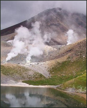
“As it is situated along the circum-Pacific volcanic belt, Japan has several volcanic regions — usually considered to number seven “from the far north to the far south. Of the total number of volcanoes, approximately 80 are active, including Mt. Mihara on Izu Oshima island, Mt. Asama on the border between Nagano and Gunma Prefectures, and Mt. Aso in Kumamoto Prefecture. Japan has almost 1/10 of the world’s approximately 840 active volcanoes, even though it has only about l/400 of the world’s land area. Mt. Fuji, which has been dormant since its last eruption in 1707, is by no means incapable of erupting again in our lifetimes. Though volcanoes can cause great harm through large eruptions, they also contribute an incalculable tourist resource. Touristic areas such as Nikko, Hakone, and the Izu Peninsula, for example, are famous for their hot springs and attractive scenery of volcanic mountains.
“As all these volcanoes attest, the Earth’s crust beneath the Japanese archipelago is unstable and full of energy. Thus Japan is among those countries most likely to suffer from earthquakes. Every year there are approximately 1,000 earthquakes which are strong enough to be felt. In January 1995, the Great Hanshin-Awaji Earthquake killed approximately 6,000 people, injured over 40,000, and left 200,000 homeless. An earthquake in Niigata Prefecture in October 2004 left over 60 people dead and more than 4,700 injured. In March 2011, a magnitude 9 earthquake was recorded off the coast of Sanriku (Tohoku) in the Pacific Ocean, and the ensuing tsunami, more than 10m high in places, hit the coast across a vast region from Tohoku to Kanto. The number of dead and missing after the earthquake and tsunami reached nearly 20,000.
Geographical Names and Japan
In the early 1990s both the U.N.'s conference on Geographical Names and the U.S. Board of Geographic names rejected suggestions by Koreans to the change the name of the body of water between Korea and Japan from the Sea of Japan to the East Sea.
In August 2007, the ninth conference for the standardization of geographical names ruled that the Sea of Japan will remain the Sea of Japan. South Korea and North Korea wanted the name to be changed to the “East Sea” or the “Sea of Korea,” names which they say have been used for more than 2,000 years. The chairman of the conference said, “I encourage the three countries involved to find a solution acceptable to all of them, taking into account any relevant solutions, or else agree to differ.”
North Korea and South Korea joined together to contest the name and argued that the “East Sea” and “Sea of Japan” names to be used concurrently until a common designation could be worked out. Japan argues that the “Sea of Japan” name has long been established and widely recognized as the name of the sea since the late 18th century.
Geology of Japan

Geologically, Japan is one of the youngest inhabited areas on earth. It regularly experiences volcanic eruptions and earthquakes. Around Tokyo much of the landscape is made up of marine sediments — deposited when the area was occupied by seas — covered by layers of ash from eruptions by Haokone, Mt. Fuji and other volcanoes.
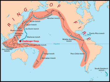
Japan lies on the Pacific Ring of Fire and is home to 108 of the world’s 1,500 or so active volcanos, including more than 10 percent of the active volcanos that are a threat to human populations. Volcanos in Japan are ranked A to C in accordance with the degree of their volcanic activity, with A being the most active. Some A volcanos have erupted 400 times a year. Mt. Fuji is classified as an active volcano even though it hasn't erupted since 1707.
Japan is riddled with faults and is located at the junction of four tectonic plates. In the last 75 years, the Japanese archipelago or areas immediately offshore have experienced five earthquakes measuring more than eight on the Richter scale; and 17 measuring more than seven on the Richter scale. It is unusual for a year to go by without three or four earthquakes measuring 6.0 or more.
Japan's First Glaciers Have Been Found
In April 2012, Jiji Press reported: “A Japanese research team has confirmed that large bodies of ice discovered in the Tateyama mountain range in central japan satisfy the definition of glaciers. The bodies of ice, found in three places in Toyama Prefecture, are the first confirmed glaciers in Japan. Previously, no glacier was known to exist in the region south of the Russian peninsula of Kamchatka. It was learned that the Japanese Society of Snow and Ice reached its conclusion by analyzing research by the Tateyama Caldera Sabo Museum in Tateyama, Toyama Prefecture. Its findings will be reported in the May edition of the society's newsletter. [Source: Jiji Press, April 6, 2012]
Snow in valleys and streams at high altitudes remains even during the summer. This snow may cover large bodies of ice, which may be considered glaciers if they move for at least one year. Using the Global Positioning System, the museum tracked the movements of bodies of ice in the Sannomado and Komado valleys of the 2,999-meter-high Mt. Tsurugi and the Gozenzawa snow valley of Mt. Oyama, which is 3,003 meters high.In research conducted in 2010 and 2011, the museum confirmed that the ice moved 10 to 30 centimeters per month. All three bodies of ice are considered independent glaciers. "I'm very happy [the bodies of ice] have been recognized as glaciers," said museum member Kotaro Fukui, who participated in the study."We will continue our research," he said, noting that there are more bodies of ice that may satisfy the definition of glaciers.
Japan’s Southernmost Island

size, latitude comparison with the U.S. The southernmost point of Japan is a heliport on Okinotori Island — about 1,700 kilometers south of Tokyo. The landing pad sits on a 50-meter-wide foundation intended for an unbuilt lighthouse planned built before World War II. Japan claims the waters around the island — an area of 400,000 square kilometers, which is the total land area of Japan.
Okinotori island embraces a coral reef that has a circumference of 11 kilometers during low tide. At high tide just two peaks — including the one with the heliport’sit above the ocean surface. Located in a strategic spot between Taiwan and Guam, it requires regular “maintenance” to keep it from submerging. China claims that Okinotori is a rock not an island and Japan has no right to claim it or the waters around it. It opposes the “maintenance” efforts.
There has been some discussion of employing new technology that creates sand from substances in seawater to help protect Okinotori from erosion. The technology — called the electrodeposition method — uses electrodes with negative charges that attract calcium and magnesium ions and they in turn form sandlike chemical compounds and they in turn attract coral
Twenty-Three Remote Isles Put under State Ownership
The government has placed 23 remote islands under state ownership after finishing necessary legal procedures last August, Chief Cabinet Secretary Osamu Fujimura said. The 23 islands, which are used to determine Japan's exclusive economic zones, do not include remote isles around the Senkaku Islands in the East China Sea off Okinawa Prefecture. China also claims the Senkaku Islands. This time, the designated remote islands include those under the jurisdiction of the village of Ogasawara, Tokyo; Ishigaki, Okinawa Prefecture; and Tsushima, Nagasaki Prefecture. [Source: Yomiuri Shimbun, March 8, 2012]
“Under the Civil Code, unowned land is vested in state coffers. The government has confirmed that the isles had no owners after checking property registers. The government has been strengthening its control over remote islands based on a basic policy decided in 2009 for the purpose of maritime supervision. The state ownership of the 23 isles is in line with this policy. "The Japan Coast Guard has filed the isles as administrative assets for the purpose of contributing to stable maintenance of EEZs," Fujimura said.
“The legal steps were taken based on the National Property Law. As a reason for excluding the remote islands around Senkaku, Fujimura said: "Only remote islets around unowned islands have been placed under state ownership. Senkaku does not fall within that category." Of the three main isles of Senkaku, the state only owns the Taishojima islet. The Kubajima and Uotsurijima islets are privately owned, though they are leased and administered by the state. In a related move, the government announced a list of 39 newly named islands. These islands had been previously unnamed despite being used as reference points to draw Japan's EEZs.
Image Sources: 1) CIA map 2) Nicolas Delerue 3) 4) USGS 5) Japanese guesthouses
Text Sources: New York Times, Washington Post, Los Angeles Times, Daily Yomiuri, Times of London, Japan National Tourist Organization (JNTO), National Geographic, The New Yorker, Time, Newsweek, Reuters, AP, Lonely Planet Guides, Compton’s Encyclopedia and various books and other publications.
Last updated October 2012
