YELLOW RIVER
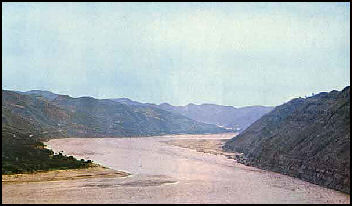
The Yellow River is the second longest river in China, the main river in north China, and the cradle of Chinese civilization as the Nile is cradle of Egyptian civilization. It originates in on Tibet-Qinghai plateau — like the Yangtze, China's largest river, and the Mekong River — and gets nearly 45 percent of its water from glaciers and vast underground springs of the Tibetan Plateau. From Tibet-Qinghai it flows for 5,464 kilometers (about 3,400 miles) through Qinghai, Gansu, Ningxia, Inner Mongolia, the border of Shaanxi and Shanxi, Henan and Shandong before it empties into Bo Hai Gulf in the Yellow Sea.
The Yellow River is known as the Huang He in China. Because the river level drops precipitously toward the North China Plain, where it continues a sluggish course across the delta, it transports a heavy load of sand and mud from the upper reaches, much of which is deposited on the flat plain. After it reaches the North China Plain, the Yellow River I is slow and sluggish along most of its course and some regard it as the world's muddiest major river, discharging three times the sediment of the Mississippi River. It gets its name and color from the yellow silt it picks up in the Shaanxi Loess Plateau . The Yellow River flows in braided streams, a network of smaller channels that weave in and out of each other. In each channel silt slowly builds the riverbed above the surrounding landscape and gives the river its devastating habit of breaking its banks and changing course.
The flow of the Yellow River is channeled mainly by constantly repaired manmade embankments; as a result the river flows on a raised ridge fifty meters or more above the plain, and waterlogging, floods, and course changes have recurred over the centuries. Traditionally, rulers were judged by their concern for or indifference to preservation of the embankments. In the modern era, the new leadership has been deeply committed to dealing with the problem and has undertaken extensive flood control and conservation measures.*
The Yellow River is a vital to making northern China inhabitable. It supplies water to 155 million people, or 12 percent of the Chinese population, and irrigates 18 million acres — 15 percent of China's farmland. More than 400 million people live in the Yellow River basin, which overs 752,443 square kilometers (290,520 square miles). Agricultural societies appeared on its banks more than 7,000 years ago and depended on it for drinking water and irrigation as they do today. Web Sites: Wikipedia Wikipedia
See Separate Article ROUTE OF THE YELLOW RIVER: ITS SOURCE, CITIES AND SIGHTS AND THE ORDOS BEND factsanddetails.com
Route of the Yellow River
The Yellow River originates on Tibet-Qinghai plateau and flows for 5,464 kilometers (about 3,400 miles) through seven present-day provinces and two autonomous regions — (from west to east): Qinghai, Gansu, Ningxia, Inner Mongolia, the border of Shaanxi and Shanxi, Henan and Shandong — before it empties into Bo Hai Gulf in the Yellow Sea. Initially flowing northeast from its source, the Yellow River follows a a somewhat winding path toward the sea with a large chunk of it running through the Loess Plateau, one of the historic center of Chinese civilizations, where its pick up a lot of silt that gives its yellowish-brown color.
Where the Yellow River begins, source tributaries drain into Gyaring Lake and Ngoring Lake in the Bayan Har Mountains of Qinghai. In the Zoige Basin along the border of Qinghai and Gansu border, the Yellow River loops northwest and then northeast before turning south, creating the "Ordos Loop", and then flows generally eastward across the North China Plain to the Gulf of Bohai. Major cities along river include (from west to east) Lanzhou, Yinchuan, Wuhai, Baotou, Luoyang, Zhengzhou, Kaifeng, and Jinan. The mouth of the Yellow River is located at Kenli County, Shandong. [Source: Wikipedia]
The Yellow River is commonly divided into three stages: 1) the Upper Section. roughly northeast of the Tibetan Plateau; 2) the Middle Section at the Ordos Loop; and 3) the Lower Section in the North China Plain. Tributaries of the Yellow River listed from its source to its mouth include: White River, Black River, Huang Shui, Datong River, Daxia River, Tao River, Zuli River, Qingshui River, Dahei River, Kuye River, Wuding River, Fen River, Wei River (the Wei River is the largest of these tributaries), Luo River, Qin River, Dawen River, Kuo River,
From time to time parts of the Yellow River change their routes and courses, sometimes with profound impacts. For example, the river Huai He, a major river in central China and the traditional border between North China and South China, traditionally cut through north Jiangsu to reach the Yellow Sea. However, from 1194 the Yellow River further to the north changed its course several times, running into the Huai He in north Jiangsu each time instead of its other usual path northwards into Bohai Bay. The silting caused by the Yellow River was so heavy that after its last episode of "hijacking" the Huai He ended in 1855: the Huai He was no longer able to go through its usual path into the sea. Instead it flooded, pooled up (thereby forming and enlarging Lake Hongze and Lake Gaoyou), and flowed southwards through the Grand Canal into the Yangtze. The old path of the Huai He is now marked by a series of irrigation channels, the most significant of which is the North Jiangsu Irrigation Main Channel, which channels a small amount of the water of the Huai He alongside south of its old path into the sea.
Yellow River Floods
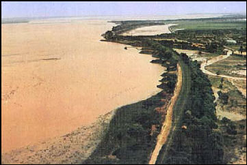
Sometimes called the "River of Sorrow," the Yellow River is one of the world's most dangerous and destructive rivers. Since historians began keeping records in 602 B.C., the river has changed course 26 times and produced 1,500 floods that have killed millions of people. The root of these disasters is the large amount of silt generated by soil erosion.
From time to time the Yellow River overflows its banks and fills huge plains with large amounts of water. Floods sometimes occur when blocks of ice block the Yellow River. About once a century these floods reach catastrophic levels.
When the levees of the Yellow River break, which happens with some regularity, the countryside is devastated. When the river's dikes were breached in 132 B.C., floods occurred in 16 districts and a new channel was opened in the middle of the plain. Ten of millions of peasants were affected. The break remained for 23 years until Emperor Wu-ti visited the scene and supervised its repair.
In A.D. 11, the Yellow River breached its dikes near the same place, and the river changed course and forged an new path to sea, a hundred miles away from its former mouth. Repair work took several decades.
In a tactic intended to halt the southward movement of Japanese soldiers from Manchuria before World War II, Chiang Kai-shek ordered his soldiers to breach the levees of the Yellow River and purposely divert its flow. At least 200,000, maybe millions, died, millions more were made homeless and the Japanese advanced anyway.
Sometimes when the Yellow River floods it becomes like a flowing mudslide. The river normally carries an enormous amount of silt and the amount increases when it floods. During a 1958 flood sediment levels were measured at 35 pounds per square foot, causing the river surface to become “wrinkled.
Yellow River Silt
Each year 1.5 billion tons of soil flows into the Yellow River. Sometimes there is so much sediment in the river it looks like chocolate milk. Three fourths of this silt ends up in the Yellow Sea, with the remainder settling in the river beds, causing the level of the river to rise. Over the centuries the river has risen between 15 and 40 feet above the surrounding plains, in some cases with silt blocking off natural drainage channels and making areas more prone to flooding.
The middle section of Yellow River in the Loess Plateau supplies 92 percent of the river's silt. The large amount of mud and sand discharged into the river makes the Yellow River the most sediment-laden river in the world. The highest recorded annual level of silts discharged into the Yellow River was 3.91 billion tons in 1933. The highest silt concentration level was recorded in 1977 at 920 kilograms per square meter. These sediments are mostlt deposit in the slower lower sections of the river, elevating the river bed and creating the famous "river above ground"
Technical problems posed by the large amount of silt and the rising water levels include: 1) the need to build higher and higher levees; 2) the need to continuously dredge large amounts of silt; 3) creating channels to release floods; and 4) building of dams to control floods. Dam building presents its own problems. The reservoir behind the Soviet-designed Yellow River dam built at Sanmenxia in 1960 silted up after only two years.
Yellow River: "River above Ground"
To hold the river back and prevent floods, the Chinese have built 800 kilometers of levees. Some of the levees are huge. Because water levels in the river rise every year, the levees also have to be raised. In many places the river has sat above the surrounding landscape for some time. The journalist Edgar Snow wrote in 1961: "The riverbed [is] twenty to twenty-five feet above the surrounding countryside. I have watched junks sail overhead at that height."
Today, the Yellow River is above the landscape for much of its last 800 kilometers (500 miles) to the sea and the river continues to rise at an alarming rate of four inches a year. If a levee breaks, larger tracts of the countryside are vulnerable to flooding. Much of the silt, sand and mud carried by the Yellow River originates in the faster-flowing upper reaches but is largely deposited on the flat plain, where the river flow is much slower.
Artificial embankments that channel the flow require constant repair. In some places the river flows on a raised ridge that is 50 meters (164 feet) m) or more above the plain. Still enough sediment reaches the sea, where deposits have created a kind of continental shelf (a Distal Depocenter) around the Shandong Peninsula in the Bohai Sea extending to the North Yellow Sea and South Yellow Sea.
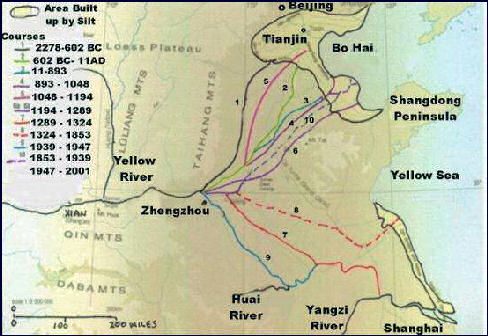
Changing Yellow River courses
Drying Up of the Yellow River
The Yellow River has dried up more than 30 times since 1972, when it ran dry for the first time in recorded history. It ran dry all but one year in the 1990s. In 1994, it ran dry for 122 days along a 180-mile section in Shandong, not far from where it empties into the Yellow Sea. In 1996 it ran dry 136 days. In 1997, for 226 days, denying water to 7.4 million acres of farmland and producing a dry riverbed that stretched more than 372 miles. The outflow o the river is just 10 percent of what t was in the 1940s. Timely releases of reservoir water kept it from drying up in the 2000s.
The Yellow River wasn't always like this. A resident of one town on the river told the Los Angeles Times, "Forty years ago, their was so much water that you could sit on the embankment, wait for fish to swim by, and go down ad catch them." Now he said, "There are no fish because there's not enough water for them to grow." In some places heavy equipment mines sand from the dry river bottom for construction work.
Water levels in 2008 were 60 percent of normal. In the early months of 2008, 600 million cubic meters of water was diverted to Beijing and Hebei and Shandong Provinces to help with a drought there an ensure there were adequate water supplies for the 2008 Olympics. More than 70 million cubic meters was diverted to the city of Qingdao, where the Olympics sailing events were held.
The Yellow River's problems begin at its source where droughts in the Tibetan plateau have reduced the amount of water flowing to the river. But the main reason the river runs dry is because between 80 to 90 percent of its water had been taken upstream for urban areas, industry and agriculture. Decline of water caused by global warming and the melting of Tibetan glaciers could make the situation worse.
Demand for and Waste of Yellow River Water
Li Xiaoqiang of the Yellow River Conservancy Commission told AFP, “Everyone wants more water, the dams want water for electricity, the industries want water to increase production, the farmers want more water for irrigation and cities need water for daily living. We estimate that some provinces and regions will see rather large shortages during peak water use periods."
A lot of water is wasted. Agriculture swallows up 65 percent of the Yellow River's water, with more than half lost to leaky pipes and ditches, with rest swallowed up by industry and cities. Twenty major dams punctuate the Yellow River and another 18 are scheduled to be built by 2030. Dams are particularly damaging on the Yellow River because they exacerbate silting and pollution. The reduced flow cause by dams causing silt to settle and prevents the flushing out if pollutants.
To keep the river flowing efforts are being made to distribute water more equitably and use it more efficiently. In August 2006, new laws were passed to better manage and reduce fights over the Yellow River. Beijing gave broad authority to the Water Resources Ministry to oversea management of the river in 11 provinces and municipalities and gave it a mandate to impose stiff fines and sanctions on officials that don't comply with the rules or take more than their share of water.
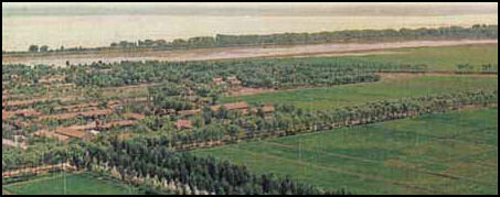
Yellow River Plain in Shandong
Yellow River: the Birthplace of Chinese Civilization?
The Yellow River is regarded at the cradle of Chinese civilization and culture. Some of the Yellow River valley’s earliest cultures and civilizations are in present-day Henan Province. Among the most famous ones are the Neolithic Peiligang Culture and Yangshao Culture, where some of the world’s first writing, alcoholic drinks and musical instruments appeared 8,000 years ago.
A thriving New Stone Age culture in the Yellow River basin raised crops in the fertile yellow soil of Shaanxi Loess region around Yellow River before 4000 B.C., and began irrigating this land at least around 3000 B.C. By contrast, people in Southeast Asia at this time were still mostly hunter gatherers that used pebble and flake stone tools. The situation wasn’t that different in Europe.
According to the National Palace Museum, Taipei: “In the north covered in loess and yellow earth, the flowing Yellow River gave birth to the splendid ancient Chinese culture. Inhabitant in this area excelled in pottery with patterns of multi-colored twisting and turning patterns. Compared to the animal motifs popular among the inhabitants in the coastal area to the east, they instead created simple yet potent jade objects with geometric designs. Their circular pi and square "ts'ung" were concrete realization of a universal view, which saw the heavens as round and he earth as square. The segmented pi disk and large circular jade designs may represent the concepts of continuity and eternity. The existence of edged jade objects in great numbers seems to bear out what is recorded in the annals of the Han Dynasties: "In the times of the Yellow Emperor, weapons were made were made of jade." [Source: National Palace Museum, Taipei npm.gov.tw \=/ ]
Traditionally it was believed that Chinese civilization arose in the Yellow River valley and spread out from this center. Recent archaeological discoveries, however, reveal a far more complex picture of Neolithic China, with a number of distinct and independent cultures in various regions interacting with and influencing each other. The best known of these is the Yangshao culture (5000-3000 B.C.) of the middle Yellow River valley, known for its painted pottery, and the later Longshan culture (2500-2000 B.C.) of the east, distinguished for its black pottery. Other major Neolithic cultures were the Hongshan culture in northeastern China, the Liangzhu culture in the lower Yangzi River delta, the Shijiahe culture in the middle Yangzi River basin and primitive settlements and burial grounds found at Liuwan in Qinghai Province, Wangyin in Shandong Province, Xinglongwa in Inner Mongolia, and the Yuchisi in Anhui Province, among many others. [Source: University of Washington]
Archaeologists now believe that the Yangtze River region was just as much of a birthplace of Chinese culture and civilization as the Yellow River basin. Along the Yangtze archeologists have discovered thousands of items of pottery, porcelain, polished stone tools and axes, elaborately carved jade rings, bracelets and necklaces that date back to at least 6000 B.C.
Peiligang Culture and Jiahu
The Peiligang culture is the name given by archaeologists to a group of Neolithic communities in the Yi-Luo river basin in Henan Province, China. The culture existed from 7000 to 5000 B.C.. Over 100 sites have been identified with the Peiligang culture, nearly all of them in a fairly compact area of about 100 square kilometers in the area just south of the river and along its banks. The culture is named after the site discovered in 1977 at Peiligang, a village in Xinzheng County. Archaeologists think that the Peiligang culture was egalitarian, with little political organization. [Source: Wikipedia +]
Jiahu is a rich but little known archeological site located near the village of Jiahu near the Yellow River in Henan Province in central China. About equidistant between Xian and Nanjing, the site was occupied from 9,000 to 7,700 years ago and then from 2,000 year ago to the present. In addition to yielding the world's oldest wine and some of the oldest rice and earliest playable musical instruments, it may have also yielded the earliest examples of Chinese writing.
Laura Anne Tedesco of the Metropolitan Museum of Art wrote: “The archaeological site of Jiahu in the Yellow River basin of Henan Province, central China, is remarkable for the cultural and artistic remains uncovered there. These remains, such as houses, kilns, pottery, turquoise carvings, tools made from stone and bone—and most remarkably—bone flutes, are evidence of a flourishing and complex society as early as the Neolithic period, when Jiahu was first occupied. [Source: Tedesco, Laura Anne."Jiahu (ca. 7000–5700 B.C.)", Heilbrunn Timeline of Art History, New York: The Metropolitan Museum of Art, metmuseum.org \^/]
“Fragments of thirty flutes were discovered in the burials at Jiahu and six of these represent the earliest examples of playable musical instruments ever found. The flutes were carved from the wing bone of the red-crowned crane, with five to eight holes capable of producing varied sounds in a nearly accurate octave. The intended use of the flutes for the Neolithic musician is unknown, but it is speculated that they functioned in rituals and special ceremonies. Chinese myths known from nearly 6,000 years after the flutes were made tell of the cosmological importance of music and the association of flute playing and cranes. The sound of the flutes is alleged to lure cranes to a waiting hunter. Whether the same association between flutes and cranes existed for the Neolithic inhabitants at Jiahu is not known, but the remains there may provide clues to the underpinnings of later cultural traditions in central China. \^/
“Pictograms, signs carved on tortoiseshells, were also uncovered at Jiahu. In later Chinese culture dating to around 3500 B.C., shells were used as a form of divination. They were subjected to intense heat and the cracks that formed were read as omens. The cracks were then carved as permanent marks on the surface of the shell. The evidence of shell pictograms from Jiahu may indicate that this tradition, or a related one, has much deeper roots than previously considered." \^/
See Separate Articles PEILIGANG AND JIAHU (7000-5700 B.C.): CHINA’S EARLIEST CULTURE AND SETTLEMENTS factsanddetails.com ; JIAHU: EARLY FLUTES AND WRITING AND THE WORLD’S OLDEST WINE factsanddetails.com
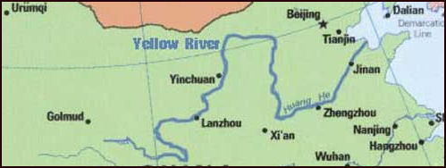
Yellow River map
Yangshao Culture
The Yangshao culture was a Neolithic culture that thrived on the Loess Plateau along the Yellow River in China. In existence from around 5000 B.C. to 3000 B.C., it is named after Yangshao, the first excavated representative village of this culture, which was discovered in 1921 in Henan Province by the Swedish archaeologist Johan Gunnar Andersson (1874–1960). The culture flourished mainly in the provinces of Henan, Shaanxi and Shanxi. Major sites includes Banpo and Jiangzhai. The Yangshao culture was preceded by the Peiligang culture (Jiahu, see separate articles), Dadiwan culture and Cishan culture. It was followed by the Longshan culture. A culture related to the Yangshao culture that emerged in the northwest is classified into three categories, the Banshan, Majiayao, and Machang, each categorized by the types of pottery produced."Sources: Wikipedia, Metropolitan Museum of Art]
The Yangshao archaeological culture is well known for its painted pottery. It consisted of hundreds of settlements along the Yellow River and Wei River regions, and stretched across the northwestern plains from Shaanxi province in central China to Gansu province in the west. Yangshao village, the source of the Yangshao name, is located near the confluence of the Yellow, Fen and Wei rivers. Around 4000 B.C, about 800 years before civilizations developed in Mesopotamia and Egypt, carefully laid-out villages were founded by hunter-farmers on the Yellow and Wei rivers.
Dr. Robert Eno of Indiana University wrote: “The Yangshao culture is one of the two great Neolithic cultures that proliferated in northern China. Its earliest sites in the Wei River valley date from about 5000 B.C., and the westernmost regions of the Yangshao culture seem to persist until approximately 2000 B.C. In other words, Yangshao culture possessed a history of three thousand years – as long as the time from the Zhou conquest of the Shang to the election of George W. Bush. Yet because Yangshao society was pre-literate, we are unable to know it in any narrative form that would convey the enduring stream of social and political drama and surely make it seem one of the great civilizations of world history...We see in Yangshao culture a likely ancestor of the elaborate kinship structures of later Chinese society and their associated ritual aesthetic.We cannot, however, identify the Yangshao people as the forbears of the warrior society of walled China. [Source: Robert Eno, Indiana University indiana.edu ]
Yanhshao is a broad term. There are many Yangshao sites. Some scholars also group Neolithic culture sites into two broad cultural complexes: the Yangshao cultures in central and western China, and the Longshan cultures in eastern and southeastern China. The Yangshao culture (5000-3000 B.C.)of the middle Yellow River valley, known for its painted pottery, and the later Longshan culture (2500-2000 B.C.)of the east, distinguished for its black pottery, are te best known of the ancient Chinese Yellow River cultures. Traditionally it was believed that Chinese civilization arose in the Yellow River valley and spread out from this center. Recent archaeological discoveries, however, reveal a far more complex picture of Neolithic China, with a number of distinct and independent cultures in various regions interacting with and influencing each other. Other major Neolithic cultures were the Hongshan culture in northeastern China, the Liangzhu culture in the lower Yangzi River delta, the Shijiahe culture in the middle Yangzi River basin and primitive settlements and burial grounds found at Liuwan in Qinghai Province, Wangyin in Shandong Province, Xinglongwa in Inner Mongolia, and the Yuchisi in Anhui Province, among many others. [Source: University of Washington]
See Separate Article YANGSHAO CULTURE (5000 B.C. to 3000 B.C.) factsanddetails.com
Yellow River Pollution
The Yellow River travels through major industrial areas, China's major coal producing region and huge population centers. By one count 4,000 of China's 20,000 petrochemical factories are on the Yellow River and a third of all fish species found in the Yellow River have become extinct because of dams, falling water levels, pollution and over fishing.
More than 80 percent of the Hai-Huaih Yellow River basin is chronically polluted. Four billion tons of waste water — 10 percent of the river's volume — flows annually into the Yellow River. Canals that empty into it that were once filled with fish are now purple from the red waste water from chemical plants. The water is too toxic to drink or use for irrigation and kills goats that drink from it.
In October 2006, a one kilometer section of the Yellow River turned red in the city of Lanzhou in Gansu Province as result of a “red and smelly” discharge from a sewage pipe. In December 2005, six tons of diesel oil leaked into a tributary of the Yellow River from a pipe that cracked because of freezing conditions. It produced a 40 mile long slick. Sixty-three water pumps had to be shut down, including some in Jinan, the capital of Shandong Province.
Every year the Yellow River absorbs 1 million tons of untreated waste from the city of Xian alone. A report issued in November 2008, declared that two thirds of the Yellow River is heavily polluted by industrial waste and is unsafe to use. The Yellow River Conservancy Committee said that 33.8 percent of the samples taken from the river in various places registered worse than Level 5, meaning it was unfit for drinking, agriculture or industrial use. Only 16.1 percent of the samples reached Level 1 or 2 — water considered safe for household use. The survey found that 73 percent of the pollutants came from industry, 23 percent came from households and 6.4 percent from “other sources." The report did not identify specific pollutants.
Around 50 percent of the river has been designated as biologically dead. In some areas along the river there have dramatic increases in cancer, birth defects and waterborne disease, Cancer rates in some places are so high they have been designated cancer villages. Among these is Xiaojidian, a village in Shandong on tributary of the Yellow River. Water from tanneries, paper mills and factories is blamed from causing 70 people to die of stomach or esophageal cancer in five year in a village with only 1,300 people. More than a thousand other in 16 neighboring villages have also died.
Yellow River Dams and Flood Control
Dr. Robert Eno wrote of Indiana University wrote: “Dams had been a feature of the Chinese landscape for centuries, particularly in the flood plain of the Yellow River, where catastrophic floods periodically laid waste to vast regions of farming. From the late Spring and Autumn period on, the increases in corvée labor available for massive public works projects led states to address this sort of problem more comprehensively than in the past – not, for the most part, cooperatively, but rather as one aspect of increasing political competition. [Source: Robert Eno, Indiana University indiana.edu /+/ ]
“Along the lower reaches of the Yellow River, the state of Qi, which extended east from the geographically lower southeast bank, constructed a great dike about eight miles to the east, greatly reducing flood damage. The states of Zhao and Wei, which shared the northwest bank and which had not been much troubled by floods, suddenly found themselves awash in the backwaters created by the dike in Qi, and the constructed their own dikes at a similar distance from the river channel. As a result, flood damage was constrained to a strip about fifteen miles wide. The rich silt deposited there by floods actually made this land highly fertile, and farmers exploited the land very actively, only slightly discouraged by the fact that every decade or two, catastrophic floods destroyed their crops and drowned them in great numbers.” /+/
See Separate Article YELLOW RIVER DAMS AND FLOOD CONTROL factsanddetails.com ;WATER PROJECTS, CANALS AND FLOOD CONTROL IN ANCIENT AND IMPERIAL CHINA factsanddetails.com
Image Sources: Wikimedia Commons, Nolls China Web site; CNTO; Perrochon photo site; Beifan.com; University of Washington; Ohio State University; UNESCO; Wikipedia; Julie Chao photo site
Text Sources: CNTO (China National Tourist Organization), China.org, UNESCO, reports submitted to UNESCO, Wikipedia, Lonely Planet guides, New York Times, Washington Post, Los Angeles Times, National Geographic, China Daily, Xinhua, Global Times, The New Yorker, Time, Newsweek, Bloomberg, Reuters, Associated Press, AFP, Compton's Encyclopedia and various books and other publications.
Updated in June 2022
