GLOBAL WARMING AND RISING SEA LEVELS
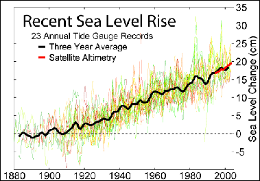
Recent Sea Level Rise Global warming is being blamed for rising seas. Sea levels rose about 10 centimeters and 20 centimeters (between four inches and eight inches) in the 20th century according to the The United Nations' Intergovernmental Panel on Climate Change (IPCC), a rate that is 10 times the average of the previous 2,000 years. In the same time global temperatures rose by more than 1̊C.
Sea levels are expected to keep rising for the next 1,000 years. The debate on the issue focuses primarily on when and how much. In 2007, the IPCC estimated the sea level rise would be between 18 centimeters a and 59 centimeters by 2100 but more recent data suggest the change could be between 50 centimeters and 1 meter. In a report published in Science in March 2006, scientists from the National Centre for Atmospheric Research warned that if current trends continue world’s sea levels could rise four to six meters by 2100. The melting of the Greenland and Antarctic ice caps would be the main cause. If such a change were to occur oceans would be at their highest levels in 130,000 years. The prediction was based on a model that considered past, present and future climates and information on past temperature rises based on ice and coral samples.
The journal Science reported that new studies show that ocean levels may rise higher and faster than previously thought. A study published in Science in 2006 by Stefan Rahnstorf of the Potsdam Institute for Climate Impact Research, for example, estimated that sea levels could rise by as much as 140 centimeters by 2100 based on the study of air temperatures and past sea level changes rather than computer models.
See Separate Article: IMPACT OF CLIMATE-CHANGE-INDUCED RISING SEA LEVELS: SALT WATER INTRUSION AND ABANDONED ISLANDS ioa.factsanddetails.com
RECOMMENDED BOOKS:
“Climate and the Oceans” (Princeton Primers in Climate) by Geoffrey K. Vallis Amazon.com
“The Encyclopedia of Weather and Climate Change: A Complete Visual Guide”
by Juliane L. Fry, Hans-F Graf, et al. Amazon.com
“Atmosphere, Ocean and Climate Dynamics: An Introductory Text” (International Geophysics by John Marshall, R. Alan Plumb Amazon.com
“Great Ocean Conveyor: Discovering the Trigger for Abrupt Climate Change”
by Wally Broecker Amazon.com
“Beyond Extinction: The Eternal Ocean―Climate Change & the Continuity of Life”
by Wolfgang Grulke Amazon.com
“The Unnatural History of the Sea” by Callum Roberts (Island Press (2009) Amazon.com
“The Ocean of Life: The Fate of Man and the Sea” by Callum Roberts Amazon.com
“Plastic Soup: An Atlas of Ocean Pollution” by Michiel Roscam Abbing Amazon.com
“Blue Hope: Exploring and Caring for Earth's Magnificent Ocean” by Sylvia Earle (2014) Amazon.com
“The Empty Ocean” by Richard Ellis (2003) Amazon.com
“Oceans: The Threats to Our Seas and What You Can Do to Turn the Tide” by , Jon Bowermaster (2010) Amazon.com
“Dark Side of The Ocean: The Destruction of Our Seas, Why It Maters, and What We Can Do About It” by Albert Bates Amazon.com
“Ocean's End: Travels Through Endangered Seas” (2001)
by Colin Woodard Amazon.com
“The Blue Machine: How the Ocean Works” by Helen Czerski, explains how the ocean influences our world and how it functions. Amazon.com
“The Science of the Ocean: The Secrets of the Seas Revealed” by DK (2020) Amazon.com
“Atmospheric and Oceanic Fluid Dynamics: Fundamentals and Large-Scale Circulation” by Geoffrey K. Vallis (2006) Amazon.com
“Essentials of Oceanography” by Alam Trujillo and Harold Thurman Amazon.com
“Ocean: The World's Last Wilderness Revealed” by Robert Dinwiddie , Philip Eales, et al. (2008) Amazon.com
Causes of Climate-Change-Induced Sea Level Rises
Over the last 80 million years sea levels have dropped by about 175 meters due to the lowering of basins caused by an aging, subsiding crust and continental drift. Sea levels have also risen and fallen as a result of ice ages in the past.
Tim Folger wrote in National Geographic: “Global warming affects sea level in two ways. About a third of its current rise comes from thermal expansion—from the fact that water grows in volume as it warms. The rest comes from the melting of ice on land. So far it’s been mostly mountain glaciers, but the big concern for the future is the giant ice sheets in Greenland and Antarctica. In 2007, the Intergovernmental Panel on Climate Change (IPCC) issued a report predicting a maximum of 23 inches of sea-level rise by the end of this century. But that report intentionally omitted the possibility that the ice sheets might flow more rapidly into the sea, on the grounds that the physics of that process was poorly understood. [Source: Tim Folger, National Geographic, September 2013]
Climate scientists now estimate that Greenland and Antarctica combined have lost on average about 50 cubic miles of ice each year since 1992—roughly 200 billion metric tons of ice annually. Many think sea level will be at least three feet higher than today by 2100. Even that figure might be too low.
““In the last several years we’ve observed accelerated melting of the ice sheets in Greenland and West Antarctica,” says Radley Horton, a research scientist at Columbia University’s Earth Institute in New York City. “The concern is that if the acceleration continues, by the time we get to the end of the 21st century, we could see sea-level rise of as much as six feet globally instead of two to three feet.” Last year an expert panel convened by the National Oceanic and Atmospheric Administration adopted 6.6 feet (two meters) as its highest of four scenarios for 2100. The U.S. Army Corps of Engineers recommends that planners consider a high scenario of five feet.
Ice Ages and Ice Age Glaciers
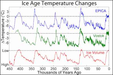
Ice Age Temperature For at least the last two million years, the earth's climate has fluctuated between ice ages. These cycles are largely driven by slight changes in the way the earth orbits around the sun -- just small changes in the various wobbles of the earth's motion are sufficient to fundamentally shift the earth from an "ice-house" to a "hot-house".
Ice Ages are periods of time when huge continental glaciers (sheets of ice) crept down from the Arctic and covered much of North America and Europe. The Pleistocene Age, which lasted from 1,000,000 (or 500,000) to 10,000 years ago, is regarded as the period of ice ages, even though the first Ice Age glaciers began appearing around 2 million years ago and large glaciers had covered landmasses for millions of years before that.
The tremendous size of the ice sheet lowering sea level about 140 meters (450 feet) below the present level; the water contained in the ice and snow came from the oceans. The continental shelves around our continent, as well as the other continents of the world, were above water and, as a result, some States such as Florida were much larger than they are today. The shoreline deposits and shells at the edge of the Continental Shelf, in waters to 450 feet deep, are evidence of this marked drop in sea level during the Pleistocene. [Source: Schlee, Our Changing Continent: USGS General Interest Publication, Online, January 2001
See Separate Article ICE AGES AND ICE AGE GLACIERS factsanddetails.com
2011 Study Predicts Sea Levels Could Rise up to 1.6 Meters by 2100
Alister Doyle of Reuters in May 2011, “Quickening climate change in the Arctic including a thaw of Greenland's ice could raise world sea levels by up to 1.6 meters by 2100, an international report. Such a rise -- above most past scientific estimates -- would add to threats to coasts from Bangladesh to Florida, low-lying Pacific islands and cities from London to Shanghai. It would also, for instance, raise costs of building tsunami barriers in Japan. [Source: Alister Doyle, Reuters, May 3 2011]
"The past six years (until 2010) have been the warmest period ever recorded in the Arctic," according to the Oslo-based Arctic Monitoring and Assessment Programme (AMAP), which is backed by the eight-nation Arctic Council. "In the future, global sea level is projected to rise by 0.9 meters (2ft 11in) to 1.6 meters (5ft 3in) by 2100 and the loss of ice from Arctic glaciers, ice caps and the Greenland ice sheet will make a substantial contribution," it said. The rises were projected from 1990 levels.
Arctic glaciers, ice caps and the Greenland ice sheet contributed over 40 percent of the global sea level rise of around 3 mm per year observed between 2003 and 2008," it said. The 2007 IPCC report that predicted that sea levels were likely to rise by between 18 and 59 cm by 2100 did not include a possible acceleration of a thaw in polar regions.
"It is worrying that the most recent science points to much higher sea level rise than we have been expecting until now," European Climate Commissioner Connie Hedegaard told Reuters. "The study is yet another reminder of how pressing it has become to tackle climate change, although this urgency is not always evident neither in the public debate nor from the pace in the international negotiations," she said.
The AMAP study, drawing on work by hundreds of experts, said there were signs that warming was accelerating. It said the Arctic Ocean could be nearly ice free in summers within 30 to 40 years, earlier than projected by the IPCC. "There is evidence that two components of the Arctic cryosphere -- snow and sea ice -- are interacting with the climate system to accelerate warming," it said.
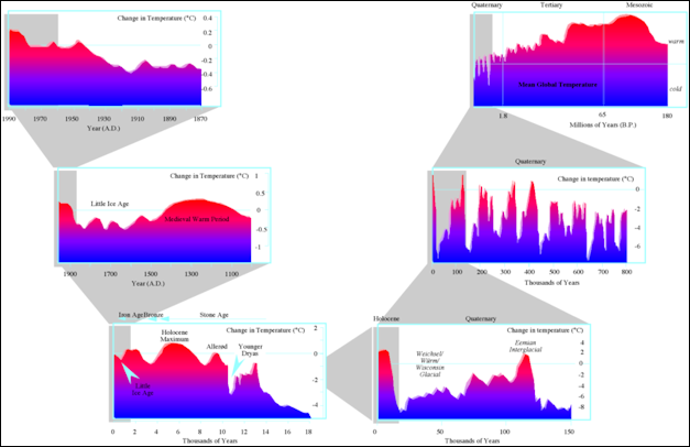
Ice Age time-slice
Greenland and Antarctica and Global Warming
Greenland and the West Antarctic ice sheets together hold 20 percent of the world’s fresh water. Much of this water is locked up in ice shelves “thick plates of ice protruding from the land and floating on the sea and almost exclusively in Antarctica, Patagonia and Greenland. As the ice shelf move they produce ice quakes as powerful as earthquakes. Warmer temperatures are causing the ice in glaciers to soften. Water is dripping down through the glaciers, lubricating their bottoms. If the tongues — the part of large glacier or ice shelf that floats on the sea — give way, the glaciers or ice shelve could start flowing even more rapidly. The tongue of a glacier has been compared to a cork or a buttress. that holds the ice shelf in place. One geophysicist told the Los Angeles Times, “If you remove the buttress, the cathedral will collapse.”
The disintegration of these ice sheets becomes increasingly more likely if temperatures rise above 5 degrees F. In a worst case scenario, ice caps of Greenland and the coastal shelf of West Antarctica and could melt significantly, raising oceans levels by six to nine meters (20 to 30 feet). Recent studies have shown that giant glaciers are capable of moving faster than previously thought. This is based studies of ice shelves in Antarctica, which are moving quicker and melting faster than had been previously been thought possible. Global warming could lead to more snow and this could thicken the ice capes. While they are gaining some mass in their interiors due to increased snowfall, they are losing ice around their edges.
Elizabeth Weise wrote in USA Today: Time is running out for the world's largest ice sheets. Both the Antarctic and Greenland ice sheets are melting, and the Antarctic is believed to be the most unstable. If they melt entirely, it would cause catastrophic sea level rise around the globe. Loss of the Antarctic sheet could result in as high as 3.4 meters (11 feet of rise). Loss of the Greenland sheet could be seven meters (23 feet), said Timothy Lenton, chair of climate change and Earth system science at the University of Exeter, United Kingdom. [Source: Elizabeth Weise, USA Today, April 7, 2022]
"About 90 percent of the transportation worldwide goes over the ocean and all port infrastructure is at sea level – you can see what a problem this will cause," said Peter Schlosser, director of the Global Futures Laboratory at Arizona State University.Though the rise probably will take much longer, it could happen as quickly as 100 years from now for Antarctica and 300 years for Greenland, a paper by Lenton found. “I know that might seem a long way off, but you’d be talking about having to move many coastal megacities in the next 100 or 150 years,” he said.
Greenland and Rising Sea Levels
The Greenland ice sheet averages 1600 meters in thickness, reaching peaks of 3,000 meters, and covers 700,000 square miles, enough to cover Mexico. Snow that fell 250,000 years ago is stored in its interior. The weight of the ice on the Greenland landmass is so high that it pushes the land below sea level and conceals the fact that Greenland may be made of three islands. Twelve major outlet glaciers move snow and ice to the sea.
The Greenland ice cap is thought be more vulnerable to global warming changes than Antarctica. It is losing about 200 cubic kilometers of ice per year, compared to about 100 cubic kilometers per year in the mid 1990s and is losing ice around is edges at a rate of 12 cubic miles a year. If Greenland ice cap were to melt completely it would raise sea levels by seven meters. On top of that the effect of so much freshwater entering the oceans could dramatically affect currents in the Atlantic. See Global Warming and Ocean Currents.

Antarctic iceMelting on the Greenland ice cap increased 30 percent between 1979 and 2007. In the winter of 2007-2008 it rained, something thought to be impossible a decade ago. A study in Science published in 2006 reported that the rate of slide of the Greenland ice sheets had doubled in five years to about eight miles a year and was responsible for a sixth of the annual sea level rises. Studies have also found that melting water is percolating quickly through the glacier to the bedrock, and melting is occurring at higher and higher elevations.
A study in 2005, found that the Greenland ice cap is thickening at a rate of five centimeters a year, especially in the highlands because of increased snowfall. Satellite data shows that the movement of the three largest outlet glaciers has been accelerating since 2002. The Jakobshaven glacier is moving at the alarming rate of 20 meters to 35 meters a day, depositing ice into Ilulissta Fjord, where 20 billion tons of icebergs are produced every year. The number of ice quakes has also increased.
Melting Greenland Glaciers Already Raising Sea Levels See Separate Article CLIMATE CHANGE, PERMAFROST, GREENLAND AND THE ARCTIC factsanddetails.com
Antarctica and Rising Sea Levels
Climate change is melting the floating ice shelves along the Antarctic peninsula giving a hint to what might happen if ice shelves around the entire continent began melting. Antarctica contains 91 percent of the world’s glacier ice. If all the land-based ice on Antarctica were to melt sea levels could rise 65 to 73 meters worldwide. The West Antarctic sheet covers 360,000 square miles. If it were to melt it alone would raise ocean levels by six meters. In the past during interglacial period it did collapse. If major parts of the East Antarctica ice sheet go. Sea levels could rise by over 25 meters.
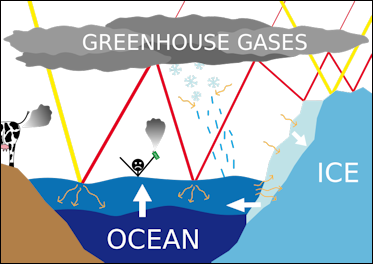
Sea-level rise scheme. In Antarctica, ice shelves are breaking up; giant icebergs are being produced; and grass is growing in places that were once hidden under ice. Much has been made about icebergs, the size of small U.S. states, breaking off from the Ross Ice Shelf (See Below). In 1995 the 1,250-square-mile Larsen A ice shelf disintegrated. In 1998 the nearby Wilkins ice shelf collapsed.
According to a study released by the University of Colorado in March 2006, the West Antarctic ice sheet is slowly melting and Antarctica is losing up to 59 cubic kilometers of ice annually. The acceleration rate of some glaciers has increased eightfold in recent years and ice is thinning at a rate of tens of meters a year.
Antarctica itself is not so vulnerable to global warming. Global warming could lead to more snow and thicken the ice cape. Antarctica itself creates a kind of deep freeze resistant to climate change. Of area thought be particularly vulnerable to climate change is the so-called “weak underbelly of West Antarctica” — an area where the ice shelves are as large as Texas and much of the land is below sea level.
Between 1950 and 2004, average temperatures rose 3 degrees C (4.5 degrees F) on the West Antarctic peninsula, the biggest rise of almost any place on Earth. Winter temperature there rose 5.9 degrees C ( 8.8 degrees F) over the same period. The rise was attributed to rising global temperatures and regional shifts in ocean and air currents. Increased snow fall caused the ice layer t become thicker.
In recent years the “ice streams” of Antarctica have been losing more ice to the sea and scientists aren’t sure why as global warming doesn’t seen to be the obvious cause as it is in Greenland. Scientists studying the phenomena say the ice is being “pushed” rather than melting with glaciers on the west side of the of Antarctica moving particularly fast.
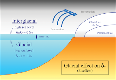
Glacial effect on sea levels
Because global warming seems to be producing additional snowfall that is causing ice to accumulate faster than it is melting some scientists estimate that the Antarctic could make sea levels five centimeters lower by 2100, and if anything global warming will cause more snow fall and increase the amount of ice locked up in Antarctica.
Thwaites — the Antarctic Doomsday Glacier
Tim Folger wrote in National Geographic: One of the biggest wild cards in all sea-level-rise scenarios is the massive Thwaites Glacier in West Antarctica. Four years ago NASA sponsored a series of flights over the region that used ice-penetrating radar to map the seafloor topography. The flights revealed that a 2,000-foot-high undersea ridge holds the Thwaites Glacier in place, slowing its slide into the sea. A rising sea could allow more water to seep between ridge and glacier and eventually unmoor it. But no one knows when or if that will happen. [Source: Tim Folger, National Geographic, September 2013]
““That’s one place I’m really nervous about,” says Richard Alley, a glaciologist at Penn State University and an author of the last IPCC report. “It involves the physics of ice fracture that we really don’t understand.” If the Thwaites Glacier breaks free from its rocky berth, that would liberate enough ice to raise sea level by three meters—nearly ten feet. “The odds are in our favor that it won’t put three meters in the ocean in the next century,” says Alley. “But we can’t absolutely guarantee that. There’s at least some chance that something very nasty will happen.”
Thwaites glacier is a massive but melting glacier that faces the Amundsen Sea and may eventually lose large amounts of ice because of warm water. Florida-sized Thwaites, the widest glacier in the world by land and sea, has gotten the nickname the “doomsday glacier” because of how much ice it has and how much seas could rise if it all melts — more than 65 centimeters (two feet) over hundreds of years. The glacier is also in one of the remotest, hard-to-get-to places in the world and thus has beee little studied. Located on Antarctica's western half, east of the jutting Antarctic Peninsula, itt is not near any of Antarctica’s research stations and is difficult to reach by sea. [Source: Seth Borenstein, Associated Press, January 6, 2022]
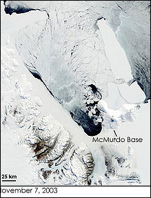
Giant iceberg B15 ““Thwaites is the main reason I would say that we have so large an uncertainty in the projections of future sea level rise and that is because it’s a very remote area, difficult to reach,” Anna Wahlin, an oceanographer from the University of Gothenburg in Sweden, said. She and other scientists did research at Thwaites in 2022 from the research vessel Nathaniel B. Palmer. “Thwaites “looks different from other ice shelves,” Wahlin said. “It almost looks like a jumble of icebergs that have been pressed together. So it’s increasingly clear that this is not a solid piece of ice like the other ice shelves are, nice smooth solid ice. This was much more jagged and scarred.”
It is configured in a way so that it’s potentially unstable. And that is why we are worried about this.”
Thwaites deposits about 50 billion tons of ice into the water a year. The British Antarctic Survey says the glacier is responsible for 4 percent of global sea rise, and the conditions leading to it to lose more ice are accelerating, University of Colorado ice scientist Ted Scambos said. Oregon State University ice scientist Erin Pettit said Thwaites appears to be collapsing in three ways: 1) Melting from below by ocean water. 2) The land part of the glacier “is losing its grip” to the place it attaches to the seabed, so a large chunk can come off into the ocean and later melt. 3) The glacier’s ice shelf is breaking into hundreds of fractures like a damaged car windshield. This is what Pettit said she fears will be the most troublesome with six-mile (10-kilometer) long cracks forming in just a year.
Giant Icebergs
In a 35 day period in February and March 2002, the huge 1,250-square-mile Larsen B shelf in Antarctica collapsed, losing more than a quarter of it total mass and setting thousands of icebergs adrift in the Weddell Sea. Scientists were stunned by the rapidity in which the event occurred. A huge iceberg, measuring 200 meters thick, 85 kilometers long, 64 kilometers wide and covering 3,250 square kilometers (1,250 square miles), broke off. Massive icebergs have broken off before. An iceberg the size of Delaware broke from Antarctica in October 1987. In 1958 an iceberg was spotted that was thought to be the size of Belgium.
In 2000, an iceberg dubbed B15 broke off from Antarctica. The iceberg initially covered 29,525 square kilometers (11,400 square miles) — an area the size of Jamaica — but split several times. The iceberg is thought to have killed millions of penguins after it blocked their access to the sea from the Ross Ice Shelf. The remnant of B15, B15A was still floating around in 2005 and measured 3.100 square kilometers (1,200 square miles).
The A68A iceberg was part of the Larsen-C Ice Shelf on the Antarctica peninsula before it broke off in July 2017. At the time, it was the biggest iceberg on Earth at 5,720 square kilometers (2,208 square miles), larger than the state of Delaware. It was estimated that glacier released over 167 billion tons of freshwater during a three-month period and nearly one trillion tons in its lifespan. [Source: Jordan Mendoza, USA TODAY, January 24, 2022]
When A68A broke off, it began to drift across the Southern Ocean. In December 2020, the iceberg began to approach South Georgia island, which is around 2,000 kilometers off the Argentina coast. The island is home to many wildlife, including penguins and seals. Scientists said the iceberg broke apart just before it could have hit the seabed. A collision could have seriously damaged the island's ecosystem, including killing wildlife.
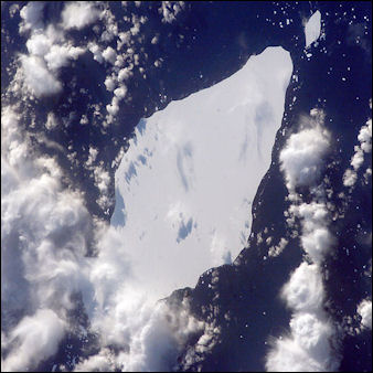
giant Iceberg A22A in South Atlantic OceanAccording to a study published in the March 1, 2022 edition of Remote Sensing of Environment.The melting was due to the iceberg's movement from the cold waters along the Drake Passage to the warmer Scotia Sea near the island. When the iceberg got near the island, it dropped in thickness from 771 feet to 219 feet, most of which occurred from November 2020-January 2021.
By April 2021, it had completely melted, totaling to992 billion tons of ice lost in its 2,485 mile journey since it first broke off in 2017. At its peak, 22 feet of ice melted each month.
Image Sources: World Meteorological Organization; National Oceanic and Atmospheric Administration (NOAA), Wikimedia Commons
Text Sources: World Meteorological Organization; National Oceanic and Atmospheric Administration (NOAA), New York Times, Washington Post, Los Angeles Times, Times of London, Yomiuri Shimbun, The Guardian, National Geographic, The New Yorker, Time, Newsweek, Reuters, AP, Lonely Planet Guides, Compton’s Encyclopedia and various books and other publications.
Last updated December 2025
