ICE AGES
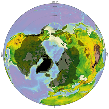
Northern Hemisphere Ice Age glaciation Ice Ages are periods of time when huge continental glaciers (sheets of ice) have crept down from the Arctic and covered much of North America and Europe. The Pleistocene Age, which lasted from 2.6-2.3 million to 11,700 years ago, is regarded as an ice age, within which there were glacial periods, which many people think of ice ages, when glaciers grew and shrunk during different periods. The first Ice Age glaciers began appearing long ago. Large glaciers have covered landmasses for millions of years at different times before the Pleistocene Age.
There has been at least five major ice ages. The first one occurred about 2 billion years ago and lasted about 300 million years. The most recent one started about 2.6 million years ago, and technically is still going on. Denise Su wrote: So why isn’t the Earth covered in ice right now? It’s because we are in a period known as an “interglacial.” In an ice age, temperatures will fluctuate between colder and warmer levels. Ice sheets and glaciers melt during warmer phases, which are called interglacials, and expand during colder phases, which are called glacials. Right now we are in the most recent ice age’s warm interglacial period, which began about 11,000 years ago. [Source: Denise Su, Associate Professor, Arizona State University, The Conversation, June 27, 2022]
Glacial Periods — What Most People Think of as Ice Ages
Ices ages have been defined by the warming and cooling of the climate and expanding and retreating of glaciers. Scientists refer the colder periods within ice ages when there is a lot of ice as glaciations and the warmer periods in between them as interglacial phases. The ice ages often last millions of years while the glacial periods last tens of thousands of years and are characterized by the glaciers expanding reaching a peak and then retreated.
The Last Glacial Maximum — roughly 25,000 to 19,000 years ago — was the coldest part of the last Ice Age.
For at least the last two million years, the earth's climate has fluctuated between glacial periods and interglacial periods. These cycles are largely driven by slight changes in the way the earth orbits around the sun — just small changes in the various wobbles of the earth's motion are sufficient to fundamentally shift the earth from an "ice-house" to a "hot-house".
The four main glacial periods of the Pleistocene Age are (the names refer to the southern limit of the glaciers in Europe and, in parentheses, the United States): 1) the Günz (known in the U.S. as the Nebraskan) occurred around 2 million years ago); 2) the Mindel (known in the U.S. as the Kansan) occurred around 1.25 million years ago); 3) the Riss (known in the U.S. as the Illinoisian) occurred around 500,000 years ago); and 4) the Würm (known in the U.S. as the Wisconsin) occurred around 100,000 years ago).
Ice Age Glaciers
During the Ice Age temperature were only 5 to 10 degrees colder than today. As recently as 20,000 years ago, glaciers hundreds and thousands of feet thick covered all of Canada, much of the United States ad most of northwestern Europe. There was less glaciation over Russia. The glaciers became so large more as a result of cool summers that failed to melt the glaciers rather than cold winters (in really cold areas there is often less snow than slightly cold areas). Every year more and more snow accumulated and created massive glaciers.
Some glaciers were more than two miles thick. The weight of all this ice caused the Earth’s crust to sink between 300 and 800 feet. In many places the land is still in the process of springing back. So much water was frozen into the glaciers that the levels of the sea was lowers by dozens, even hundreds of feet.
The tremendous size of the ice sheets influenced paleogeography by lowering sea level about 140 meters (450 feet) below the present level; the water contained in the ice and snow came from the oceans. The continental shelves around our continent, as well as the other continents of the world, were above water and, as a result, some States such as Florida were much larger than they are today. The shoreline deposits and shells at the edge of the Continental Shelf, in waters to 450 feet deep, are evidence of this marked drop in sea level during the Pleistocene. [Source: Schlee, Our Changing Continent: USGS General Interest Publication, Online, January 2001
Pleistocene Glaciations
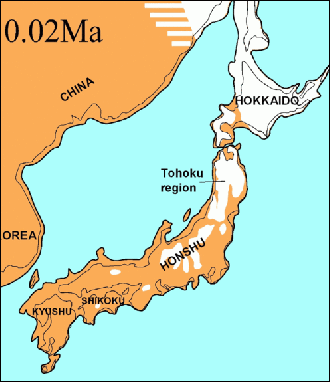
Japan glaciation During the Pleistocene Epoch Ice Age, beginning about 2.5 million years ago, virtually all of southwestern Canada was repeatedly glaciated by ice sheets that also covered much of Alaska, northern Washington, Idaho, Montana, and the rest of northern United States. In North America, the most recent glacial event is the Wisconsin glaciation, which began about 80,000 years ago and ended around 10,000 years ago. [Source: U.S. National Park Service Website, Ice Age Floods, 2002]
During the Great Ice Age, or Pleistocene Epoch, which began about 2 million years ago, large portions of Canada and the Northern United States were blanketed by the continental ice sheet. Much of the rich soil of the Midwest is glacial in origin, and the drainage patterns of the Ohio River and the position of the Great Lakes were influenced by the ice. The effects of the glaciers can be seen in the stony soil of some areas, the hilly land surfaces dotted with lakes, the scratched and grooved bedrock surfaces, and the long, low ridges composed of sand and gravel which formed at the front of the ice sheet. [Source: Schlee, Our Changing Continent: USGS General Interest Publication, Online, January 2001
Increased rainfall in the area south of the continental ice sheet formed large lakes in Utah, Nevada, and California. Remnants of these ancient lakes still exist today as the Great Salt Lake, Pyramid Lake, Winnemucca, and many others. Ancient shorelines for these old lakes can be found along the sides of mountains, as for example, near Provo, Utah.
During the Pleistocene Epoch Ice Age, beginning about 2.5 million years ago, virtually all of southwestern Canada was repeatedly glaciated by ice sheets that also covered much of Alaska, northern Washington, Idaho, Montana, and the rest of northern United States. In North America, the most recent glacial event is the Wisconsin glaciation, which began about 80,000 years ago and ended around 10,000 years ago.
Fraser Glaciation
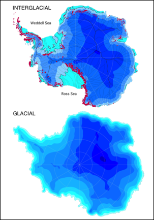
Antarctic Ice Age glaciation During the Fraser (Late Wisconsin) Glaciation, the Cordilleran ice sheet advanced southward from source areas in British Columbia and terminated in the United States between the Pacific Ocean and the Continental Divide. The ice sheet extended farthest along major south-trending valleys and lowlands that traverse the international boundary; it formed several composite lobes segregated by highlands and mountain ranges. Each lobe dammed sizable lakes that drained generally southward or westward along ice margins and across divides. [Source: Waitt, Jr., and Thorson, 1983, The Cordilleran Ice Sheet in Washington, Idaho, and Montana: IN: Wright, Jr., (ed.), 1983, Late-Quaternary Environments of the United States, Volume 1: The Late Pleistocene (Porter (ed.): University of Minnesota Press, 407p.
During the Fraser Glaciation the Cordilleran ice sheet occupied parts of the Fraser and Puget lowland and Strait of Juan de Fuca between about 18,000 and 13,000 B.P., after the maximum stand of nearby alpine glaciers. At its maximum extent about 14,500 to 14,000 years B.P., the ice-sheet surface sloped from about altitude 1,000 meters at the international boundary to between 0 and 300 meters at the ice terminus on the continental shelf and in the southern Puget lowland. Drainage from deglaciated alpine valleys in the Cascade Range and Olympic Mountains flowed southward along both ice margins and coalesced into meltwater streams that built broad outwash trains southward and westward to the Pacific Ocean. In the North Cascades Range, Cordilleran ice overrode high divides and inundated major drainage basins. The ice-sheet surface descended from above 2,600 meters near the international boundary to 270 meters in the Columbia River valley.
East of the Cascade Range, the Okanogan lobe extended southward as a broad lobe that dammed the Columbia River valley to form glacial Lake Columbia. The lake discharged along the course of the Grand Coulee, whose tandem gorges developed by recession of great cataracts beneath catastrophic floods from glacial Lake Missoula.
The Columbia River lobe dammed the Spokane valley to form a shallow glacial Lake Spokane. The Pend Oreille River sublobe, and eastern appendage of the Columbia River lobe, was less extensive than formerly inferred. The Priest River valley remained unglaciated except for a distributary of the Purcell Trench lobe that dammed the valley mouth.
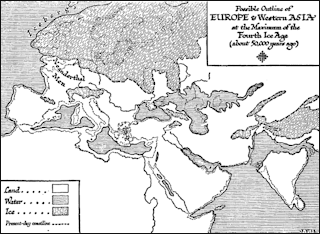
Europe’s 4th Ice AgeThe Purcell Trench lobe dammed the 2,000-cubic-kilometer glacial Lake Missoula, which successively discharged as huge jökulhlaups that flowed to Spokane along the Rathdrum valley and from upper Pend Oreille River valley. From Spokane the great floods swept across the Channeled Scabland and down the Columbia River valley.
The West Kootenai and East Kootenai glaciers flowed across a high-relief landscape, terminating within a general upland. The Flathead lobe was more extensive than formerly inferred. Both the Flathead lobe and nearby alpine glaciers reached near-maximum positions during high stands of Lake Missoula and thus during the maximum stand of the Purcell Trench lobe. Topographic lows trending south from southern British Columbia fed each of the major lobes of the Cordilleran ice sheet east and west of the Cascade Range, but the secondary lobation of the ice margins was determined by the configuration of local valleys.
As the Puget lobe retreated northward, ice-marginal streams and proglacial lakes progressively expanded northward. Glacial Lake Russell drained southward during initial retreat; glacial Lake Bretz later drained northward. Calving into seawater, the Juan de Fuca lobe retreated rapidly and perhaps thereby caused the northwestern part of the Puget lobe to stagnate. Continued ice retreat permitted the sea to enter Puget Sound, and a glaciomarine interval ensued from 13,500 to 11,500 years B.P. Stillstands or readvances of the ice margin occurred during and near the end of the glaciomarine interval. In the northeastern Cascade Range and Waterville Plateau, deglaciation occurred by progressive downwasting and backwasting of ice whose margins frequently stagnated. Most lobes east of the Cascade Range built one or more small recessional moraines. As ice tongues retreated, glacial Lakes Columbia and Missoula fell to successively lower levels as they grew northward behind retreating ice. At length the early lakes were succeeded by glacial Lakes Brewster, Clark, and Kootenay.
The apparent absence of the Glacier Peak layer-G tephra within the northern part of its projected fallout area along with the occurrence of several jökulhlaups from glacial Lake Missoula after the Mount St. Helens set-S airfall suggest that much of the glaciated terrain east of the Cascade Range remained glaciated until about 13,000 years ago. In the North Cascade Range, erratics transported by the ice sheet up valleys to cirque floors indicate that, as the ice sheet disappeared, alpine glaciers did not rejuvenate much below the limits of modern glaciers. Although ice lobes both east and west of the Cascade Range generally retreated from terminal positions to the international boundary during the interval 14,000 to 11,000 years B.P., the lobes were not exactly in phase with each other. Particular stillstands and retreats were influenced by local conditions such as topography or seawater that did not affect all lobes equally.
Wisconsin Glaciation
During the Pleistocene Epoch Ice Age, beginning about 2.5 million years ago, virtually all of southwestern Canada was repeatedly glaciated by ice sheets that also covered much of Alaska, northern Washington, Idaho, Montana, and the rest of northern United States. In North America, the most recent glacial event is the Wisconsin glaciation, which began about 80,000 years ago and ended around 10,000 years ago. [Source: U.S. National Park Service Website, Ice Age Floods, 2002
A mere 15,000 years ago, during the Ice Age, most of northern America lay under the grip of colossal ice sheets. The effects of the advancing and retreating glaciers can be seen in the headlands of Cape Cod, the Finger Lakes of New York, and the hills of Michigan, but nowhere is the glacier's mark upon the land more impressive than in Wisconsin. Indeed, the state has lent its name to the most recent series of glacial advances and retreats — the Wisconsin Glaciation lasting from about 100,000 to 10,000 years ago.
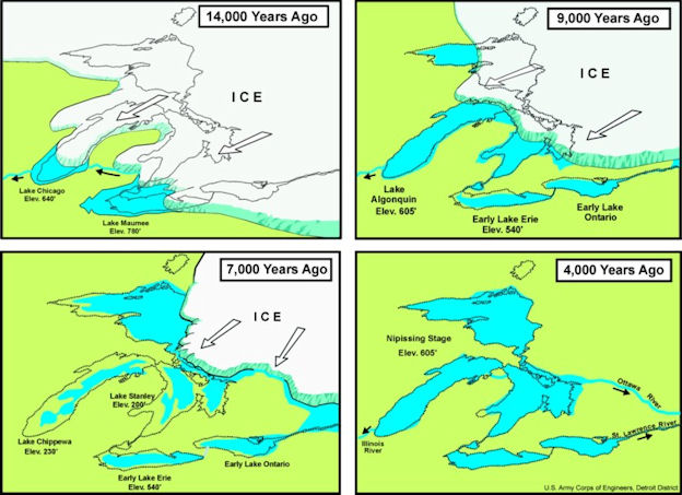
Glacial Lakes
Last Ice Age
Denise Su wrote: When most people talk about the “ice age,” they are usually referring to the last glacial period, which began about 115,000 years ago and ended about 11,000 years ago with the start of the current interglacial period. During that time, the planet was much cooler than it is now. At its peak, when ice sheets covered most of North America, the average global temperature was about 46 degrees Fahrenheit (8 degrees Celsius). That’s 11 degrees F (6 degrees C) cooler than the global annual average today. That difference might not sound like a lot, but it resulted in most of North America and Eurasia being covered in ice sheets. Earth was also much drier, and sea level was much lower, since most of the Earth’s water was trapped in the ice sheets. Steppes, or dry grassy plains, were common. So were savannas, or warmer grassy plains, and deserts. [Source: Denise Su, Associate Professor, Arizona State University, The Conversation, June 27, 2022]
Around 125,000 years ago, in the middle of major warm, interglacial period, sea levels were 20 to 30 feet higher than they are today. Areas of Africa, the Middle East and West Asia that are desert today were covered by tropical deciduous forests and savanna dotted with numerous lakes. After that the climate began getting colder. By around 100,000 years a new Ice Age had begun. About 65,000 years, in the middle of the ice age, glaciers covered nearly 17 million square miles, including much of northern Europe and Canada, and sea levels were more than 400 feet lower that they are today. Many islands and land masses that are now separated by ocean water were connected by land bridges. Among the land masses that were connected were Australia and Indonesia, and Alaska and Siberia.
Around 40,000 years ago glaciers began to melt. At that time they still covered most of Britain and extended into Europe as far south as Germany. By around 17,000 years ago they had retreated from Germany. Around 13,000 they had retreated from Sweden. The last glacial period (the Ice Age to many) officially ended about 10,000 years ago.
Last Ice Age Landscape, Ecosystem and Animals
During the last ice age (interglacial period) the landscape of Europe and North America was covered by ice. But it was also altered in other ways not directly related to the ice. As the glaciers moved southward, for example, forests were replaced with tundra and steppe. Europe was covered mostly by open steppe which is an ideal habitat for grazing animals like horses, rhinos, deer, mammoth, reindeer and bison. Vast herds of these animals, fed on steppe grasses, roamed across Europe and Asia. As the Ice Ages ended and the climate warmed up, the habitant for the large animals herds declined as the grasslands were replaced by birch and evergreen forests.
Denise Su wrote: Many animals present during the ice age would be familiar to you, including brown bears, caribou and wolves. But there were also megafauna that went extinct at the end of the ice age, like mammoths, mastodons, saber-toothed cats and giant ground sloths. There are different ideas about why these animals went extinct. One is that humans hunted them into extinction when they came in contact with the megafauna. [Source: Denise Su, Associate Professor, Arizona State University, The Conversation, June 27, 2022]
Elizabeth Kolbert wrote in The New Yorker: “Among ecologists, the prevailing view of Europe in its natural, which is to say pre-agrarian, state is that it was heavily forested. (The continent’s last stands of old-growth forest are found on the border of Poland and Belarus, in the Bialowieza Forest, which the author Alan Weisman has described as a “relic of what once stretched east to Siberia and west to Ireland.”)” An ecologist named Frans “Vera argues that, even before Europeans figured out how to farm, the continent was more of a parklike landscape, with large expanses of open meadow. It was kept this way, he maintains, by large herds of herbivores—aurochs, red deer, tarpans, and European bison. (The bison, also known as wisents, were hunted nearly to extinction by the late eighteen-hundreds.) [Source: Elizabeth Kolbert, The New Yorker , December 24 & 31, 2012]
See Separate Articles: STONE AGE ANIMALS: CAVE LIONS AND HYENAS AND GIANT APES factsanddetails.com ; WOOLLY RHINOS AND CAVE BEARS factsanddetails.com ; WOOLLY MAMMOTHS: CHARACTERISTICS, HABITAT AND DIET factsanddetails.com ; MAMMOTHS, HUMANS, HUNTING AND CLONING factsanddetails.com
Modern Humans During the Last Glacial Period
Denise Su wrote: People just like us lived through the ice age. Since our species, Homo sapiens, emerged about 300,000 years ago in Africa, we have spread around the world. During the ice age, some populations remained in Africa and did not experience the full effects of the cold. Others moved into other parts of the world, including the cold, glacial environments of Europe. [Source: Denise Su, Associate Professor, Arizona State University, The Conversation, June 27, 2022]
And they weren’t alone. At the beginning of the ice age, there were other species of hominins — a group that includes our immediate ancestors and our closest relatives — throughout Eurasia, like the Neanderthals in Europe and the mysterious Denisovans in Asia. Both of these groups seem to have gone extinct before the end of the ice age.
There are lots of ideas about how our species survived the ice age when our hominin cousins did not. Some think that it has to do with how adaptable we are, and how we used our social and communication skills and tools. And it appears that humans didn’t hunker down during the ice age. Instead they moved into new areas.
For a long time it was thought that humans did not enter North America until after the ice sheets started to melt. But fossilized footprints found at White Sands National Park in New Mexico show that humans have been in North America since at least 23,000 years ago — close to the peak of the last ice age.
Causes of the Ice Ages, Ocean Currents and Panama
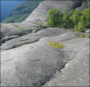
Ice Age glacial abrasion on rocks The causes of the Ice Ages are still a mystery. Some scientists have suggested that they may have been caused by climate changes brought about the movement of the Earth in relation to the sun. Others have attributed them to volcanic eruptions or high levels of atmospheric gases or clouds that shut out the warmth of the sun.
Many scientists believe the ice ages were triggered by major changes in the ocean currents. They theorize that currents that brought warm water to the northern latitudes were somehow disrupted and the flow of warm water northward was somehow cut off and thus the climate in the northern hemisphere became colder and glaciers formed and expanded.
Before 3.5 million years ago, North and South America were not connected and waters from the Atlantic and Pacific mixed and lowered salinity levels in the Atlantic, which meant that lighter water from the tropics was carried all the way to the Arctic Ocean.
When the isthmus of Panama was later created, water from the Atlantic and the Pacific no longer mixed, which increased the level of salinity in the North Atlantic Current, causing it to sink before it reached the Arctic, causing an icecap to form there. The changes also caused the northern diversion of the equatorial Atlantic Ocean current and the intensification of the Gulf Stream, which resulted in more snowfall in the north and the built up of glaciers.
These changes led to an ice age. Between 2.8 and 2.5 million years ago glaciers began creeping from the Arctic Ice cap down over much of the northern hemisphere and the climate in Africa became noticeable colder and drier. Evidence of rainfall and climate changes in the period is based on analysis of rock strata containing dust and pollen deposited in a coastal ocean-floor sediments.
Ice Age Geology and Features
Much of the landscape of Europe has been shaped in various ways by glaciation during the Ice Ages. The jagged appearance of the Alps and other European mountains was created by ice age glaciers that swept over Europe in the last few million years. The sharp snow-capped peaks, cirques, gouged lakes and gentle U-shaped curved valleys were all created by glaciers.
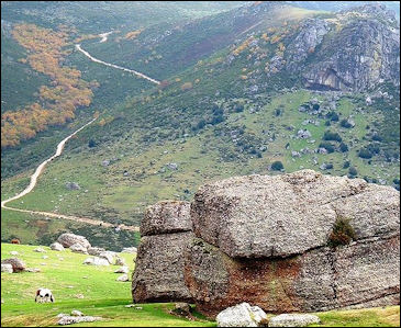
Much of Scandinavia, Northern Europe and Britain were covered by continental glaciers in the last Ice Ages. The scouring action of these glaciers created hundreds of thousands of lakes and left behind a flat or undulating landscape and rough, stony soil.
Fjords are a saltwater arms of the sea that extend inland. Many of fjords in Europe were river valleys carved out by glaciers that were flooded by the sea, when sea levels rose after the last Ice Age was finished.
Drumlins are low hills that have been created by moraine (glacial debris) left behind as the glaciers retreated.
Glaciers create lakes three main ways: 1) by carving out depressions that fill with water; 2) by leaving behind debris on a flat landscape that blocks rivers or traps water in other ways; and 3) by retreating and leaving behind debris that blocks a valley like dam, creating a lake behind it. The latter are sometimes called finger lakes.
Glacial Isostatic Adjustment
Glacial isostatic adjustment is the ongoing movement of land once burdened by ice-age glaciers. The last ice age occurred just 16,000 years ago, when great sheets of ice, three kilometers (two miles) thick, covered much of Earth's Northern Hemisphere. Though the ice melted long ago, the land once under and around the ice is still rising and falling in reaction to its ice-age burden. This ongoing movement of land is glacial isostatic adjustment. [Source: NOAA]
Here's how glacial isostatic adjustment. works: Imagine lying down on a soft mattress and then getting up from the same spot. You see an indentation in the mattress where your body had been, and a puffed-up area around the indentation where the mattress rose. Once you get up, the mattress takes a little time before it relaxes back to its original shape.
Even the strongest materials (including the Earth's crust) move, or deform, when enough pressure is applied. So when ice by the megaton settled on parts of the Earth for several thousand years, the ice bore down on the land beneath it, and the land rose up beyond the ice's perimeter — just like the mattress did when you lay down on and then got up off of it.
That's what happened over large portions of the Northern Hemisphere during the last ice age, when ice covered the Midwest and Northeast United States as well as much of Canada. Even though the ice retreated long ago, North America is still rising where the massive layers of ice pushed it down. The U.S. East Coast and Great Lakes regions — once on the bulging edges, or forebulge, of those ancient ice layers — are still slowly sinking from forebulge collapse.
Forbulge collapse is one of the larger causes of ground movement in the United States. Many places in the Eastern U.S. have been sinking for thousands of years and will continue to sink for thousands more. In fact, estimates say land around the Chesapeake Bay will sink as much as half a foot over the next 100 years because of the forebulge collapse. Other big contributors to ground movement in the U.S. include earthquakes and subsidence. Subsidence is when the ground sinks, either due to natural causes or when resources like water, gas, and oil are pumped out of the ground.
All of these movements are monitored by NOAA's National Geodetic Survey through its nationwide network of nearly 2,000 permanent Global Positioning System stations, called Continuously Operating Reference Stations or CORS. These CORS make it possible for NOAA to provide products for use in construction, navigation, mapping, and other industries.
Image Sources: Wikimedia Commons, United States Geological Survey (USGS)
Text Sources: United States Geological Survey (USGS), New York Times, Washington Post, Los Angeles Times, Times of London, Yomiuri Shimbun, The Guardian, National Geographic, The New Yorker, Time, Newsweek, Reuters, AP, Lonely Planet Guides, Compton’s Encyclopedia and various books and other publications.
Last updated April 2024
