EARTHQUAKES
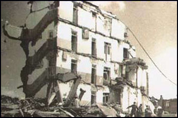
Tangshan Earthquake in 1976
An earthquake is a shaking of the ground. It occurs when large masses of rock suddenly change position. Earthquakes and tremors (small earthquakes) are occurring somewhere around the globe all the time. Some cause a little shaking and people barely know what's going on. Other cause catastrophic damage.
Earthquakes killed 1.8 million worldwide between 1900 and 2005. Hundreds of thousands have died in single events. No other natural events have caused as much destruction in human history and no other events occur with such suddenness and capriciousness. They only thing that ranks with them are catastrophic volcanic eruptions and tsunamis. The former occur with much less frequency and are easier to predict than earthquakes. The latter are generally caused by earthquakes. If anything the destructive power of earthquakes increases as time goes buy as the number of people living in earthquake-prone areas increase even as technology to help them improves.
Earthquakes usually occur on faults, massive cracks or fractures that usually are located around places that tectonic plates meet. The hypocenter or focus is the center of the energy of an earthquake, or where the earthquake originates below the surface of the earth. The epicenter is point in the earth's surface directly above the hypocenter.
See Separate Articles: CAUSES AND PREDICTIONS OF EARTHQUAKES factsanddetails.com ; EARTHQUAKE DAMAGE AND EARTHQUAKE-RESISTANT BUILDINGS factsanddetails.com EARTHQUAKE SAFETY AND SURVIVAL factsanddetails.com TSUNAMIS: CAUSES, PHYSICS AND DANGERS factsanddetails.com
Good Websites and Sources: U.S. Geological Survey (USGS) National Earthquake Information Center earthquake.usgs.gov ; Wikipedia article on Earthquakes Wikipedia ; Earthquake severity pubs.usgs.gov ; Collection of Images from Historic Earthquakes Pacific Earthquake Engineering Research Center, Jan Kozak Collection ; World Earthquake Map iris.edu/seismon Most Recent Earthquakes earthquake.usgs.gov ; Earthquake Pamphlet pubs.usgs.gov ; USGS Earthquakes for Kids earthquake.usgs.gov/learn/kids ; Earthquake Preparedness and Safety Surviving an Earthquake edu4hazards.org ; Earthquake Preparedness Guide earthquakepreparednessguide.com ; Earthquake Safety Site earthquakecountry.info
Seismic Waves
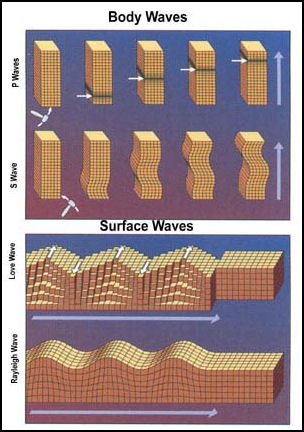
The energy of an earthquake is emitted in the form of shock (seismic) waves. There are two kinds of seismic waves: interior ones, which travel through the earth; and surface ones, which travel along the surface. Surface waves are the most damaging to humans.
Seismic waves that affect the surface are divided into P-waves and S-waves. P-waves, or primary waves, are faster and reach the surface first. They alternately compress and expand the rock which they pass through but pack relatively little energy. S-waves, or secondary waves, come later and move particles and rock from side to side perpendicular to the direction they are traveling. They are much stronger and destructive and can produce intense vibrations that rip buildings off their foundations, churn soils into molasses and cause roofs to fall on people.
Both P and S waves produce heaving and rolling surface waves, which are usually most intense along the ruptured fault and weaken as they move away from the epicenter. The seismic echos of these waves that move through the earth and along the surface. can picked up by instruments around the globe. Scientists can locate the hypocenter and epicenter of a given earthquake by comparing the arrival times of the P-waves and S-waves received at different seismic stations in different locations.
Scientists in California and Japan have figured out ways to get a few seconds warning of an earthquake by detecting fast-moving P-waves before the destructive S-waves arrive. Sixty kilometers away from the epicenter this can translate to a 20 second warning, enough for people to take actions which could save their lives. The Japanese have developed a tremor-detection system that sends out data to the media and other sources once the P-waves have been detected.
Causes of Earthquakes
Most earthquakes occur along cracks in the earth called faults. Some fault are nice neat lines that are visible from planes and outer space. Other are more complex, resembling a shattered or cracked window. Faults visible from the sky easy to locate. Others are less obvious and require some defective work to locate.
The heaviest concentrations of faults are found in places where tectonic plates meet. Along major faults, tectonic plates moves at rate of about eight or nine feet a century, or 1.3 inches a year, which is roughly about the same speed as fingernail growth.
If the movement of tectonic plates or block of earth along faults was steady and smooth earthquakes would not occur. But that is not what happens. Friction keeps the plates together until enough pressure builds up to cause the plates to suddenly lurch. When this happens energy that causes earthquakes is released.
If a small segment of a tectonic plate moves an earthquake with a magnitude of less than 6 occurs. When a large segment, or several small segments rupture, a major earthquake over 7 often occurs. Similar process are taking place with blocks of earth along smaller fault in the general area of where the tectonic plates meet.
Many earthquakes occur along subduction zone, where oceanic plates meet continental plates. Here the denser ocean plate pushes beneath the continental plate. The constant movement and pressure causes earthquakes. Earthquakes also occur along extension zones, where the crust is stretched by subduction. They have also been caused by volcanic eruptions, atomic bob blasts and even dynamite blasted from geological exploration.
For centuries scholars and thinkers have speculated about their causes and mechanisms of earthquakes. Aristotle likened them to the Earth passing gas while the Japanese speculated they were caused by a giant fish wriggling under the Earth’s surface.
Types of Earthquakes
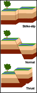
There are two main types of earthquakes: ocean trench ones, which are caused by oceanic plates pushing down on or moving under land plates; and inland quakes, which occur along fault lines between land plates. An earthquake occurring near the surface of the Earth is referred to as a “near-field” or “inland” earthquake. There are vertical and horizontal tremors.
A strike-slip, or transform, fault earthquake is a sudden lateral movement of one rock mass against another at fault in response to plate tectonic forces. During a large earthquake of this sort the rock masses on either side a fault can lurch 10 feet or more in opposite directions. Strike-slip faults are where blocks of earth slide past each other laterally. The plates lock together as pressure builds until the plates surge past each other and cause an earthquake.
A reverse fault earthquake is caused by the compression of a subduction zone. Thrust faults occur where blocks of earth collide at an angle and one block shifts upward. A normal fault earthquake is caused by the normal extension of a crustal extension where plates pull apart.
Megathrust earthquake are destructive earthquakes that occur when two plates collide. Earthquakes of this type can reach a level of 9 or more on the Richter scale while the largest earthquakes that occur on faults like the San Andreas fault can only reach a level of 8 on the Richter scale. The earthquake that caused the tsunami in Indonesia in 2004 and the 9.2 earthquake in Alaska in 1964 were a megathrust earthquake Subduction faults are usually angled at about 10 to 15 percent. Faults like San Andreas fault are roughly vertical. There is a much larger locked area with subduction zones, creating much more energy when the plates unlock
Subduction faults, angled at 10 to 15 degrees from horizontal, are significantly different from vertical faults such as the San Andreas fault in California. With a subduction fault you get a much larger locked area, so the quake can be much bigger. Vertical fault quakes tend to peak at roughly magnitude 8 while subduction quakes can be in the 9s as was the case with the quakes that spawned the 2004 tsunami in Sumatra and the Indian Ocean and the March 2011 earthquake and tsunami in Japan. .Between 8 and 9 is a factor of 30 in energy.
Measuring Earthquakes
The earthquake magnitude scale was by introduced by American geologist Charles Richter (1900-1985) in 1935 and for a long time was known as the Richter scale. This scale is logarithmic, which means that progressively bigger quakes are a lot bigger than smaller quakes. For each unit increase in magnitude (i.e., going from 6.5 to 7.5), the energy released rises by a factor of about 30 — meaning that a two-unit increase translates into a quake that is nearly 1,000 times as severe. If enough stress has built up on a fault to generate a magnitude-7.0 earthquake, say, it would thus take about 1000 earthquakes with a magnitude of 5.0 to release the equivalent energy.
Earthquakes measuring three or four on the Richter scale can be felt. Ones measuring five can cause some damage. Those rating more than six can be destructive. Those measuring more than 7 can cause great damage and many death. Earthquakes above eight are often catastrophic. The most powerful earthquakes ever recorded measured 9 and above. No 10 earthquake has ever been recorded. The destructive power of an earthquake often has more to do with where it occurs than how strong it is.
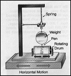
seismograph
The magnitude and intensity of earthquakes are measured with a devise called a seismograph, which records the peaks of the seismic waves. A seismograph consist of a stylus on a pendulum and a rotating drum. During an earthquake the drum moves up and down while the stylus on the pendulum remains stable.
There are 140 stations in 89 countries checking for earthquakes. The data is sifted through by 268 experts who look for secret nuclear tests as well as earthquakes. The network was set up in the 1990s and reached full global coverage in 2004. The number of stations is expect to reach 321 by 2010. The budget is $105 million. The clearing house for the data is in Vienna, where not coincidently the main United Nations nuclear watchdog agency is located.
Vibrations from earthquake and nuclear tests can be picked very far away. The instruments use to measure them are so sensitive they picked up the break up of the Columbia space shuttle in 2003 and the undersea collapse of the Russian submarine Kursk in 2000. The network that looks for nuclear explosions has 170 stations that detect underground shock waves, 11 that scan for undersea explosions as well 80 that sniff the air for radioactivity and 60 that listen for loud sounds in the atmosphere. In May 1998, shock waves from India’s nuclear test was picked up at 11 stations.
Earthquake Energy
The energy released by a 6.7 earthquake is roughly equal the energy released by a one megaton hydrogen bomb. Sometimes when scientists looking for secret nuclear tests pick up something they are not sure whether it is a nuclear explosion or an earthquake. One way they can tell is by carefully examining the shock waves recorded on a seismograph. A magnitude 6.7. earthquake begins gently and suddenly becomes more violent. A nuclear explosion of similar magnitude begins with a sharp spike, followed by aftershocks.
Large earthquakes usually create a visible crack or a displacement of surface rocks and soil and cause the fault to shift at a rate of about two miles per second. The San Francisco earthquake in 1906, which measured 7.8 on the Richter scale, caused movement along 270-mile section of fault that ranged from 6 feet to 16 feet.
Shock waves from earthquakes travel farther in places where the crust is made of old rock, but fortunately these are the places where earthquake are least likely to happen. In areas of new crust generation where earthquakes occur more frequently there are larger amounts of sand, clay and gravel. Shock waves don’t travel as far in these materials but they do more damage by concentrating their forces and causing a lot of shaking.
Aftershocks and Foreshocks
Earthquakes may be classified as foreshocks, mainshocks and aftershocks. All occur when energy in the earth’s crust is released suddenly, forcing tectonic plates to shift. What differentiates them is their relation to each other in space and time. A foreshock is only a foreshock if it happens to occur before a bigger quake on the same fault system. An aftershock occurs after a bigger quake.
Aftershocks may complete the crustal movement initiated by the original earthquake and are usually much smaller than the original earthquake but that is not always the case. Some are as powerful or almost powerful as the original. Aftershocks can occur minutes, hours, days and even years after original.
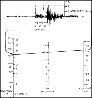
Richter scale measurement Susan Hough wrote in the Washington Post: As far as we understand, an aftershock of a certain magnitude is no different from an independent temblor of a similar magnitude. The shaking and rupture are the same; the energy released is the same. And aftershocks can be more damaging than larger “mainshocks” if they strike closer to population centers. This lesson was illustrated with the earthquake that struck Christchurch, New Zealand, in February 2011 — an aftershock of a larger but less-damaging quake that occurred the previous September. Recent studies show that any earthquake — even an aftershock — has the same small statistical chance of triggering a larger tremor. So a single quake can potentially be an aftershock and a foreshock, further clouding the differences among them. [Source: Susan Hough, Washington Post, August 26, 2011. Hough is a seismologist with the U.S. Geological Survey]
Amy Wallace wrote in Smithsonian magazine: Lucy Jones, an MIT-educated, Cal-Tech-based science adviser for the U.S. Geological Survey, is an expert on foreshocks. A lot of people had pondered foreshocks before Jones did, but she asked a critical question: After an earthquake, is there a statistical method to predict the chances that it was a precursor to a larger jolt? The answer was yes, as Jones demonstrated in a 1985 paper and subsequent studies analyzing every quake in the region’s recorded history. She found that the probability that an earthquake will trigger a bigger one does not depend on the magnitude of the first earthquake but instead is related to its location and interaction with fault systems. [Source: Amy Wallace, Smithsonian magazine, February 2012]
The southern San Andreas ruptures and releases energy on average every 150 years. The last time was more than 300 years ago, which means that Los Angeles and environs may be overdue for a major quake. There’s no way to predict precisely when California’s next “big one” will come, Jones says (or even that it will occur on the San Andreas), but people need to get ready, as was made painfully clear in a massive 2008 study Jones led.
Earthquake Geology
Earthquakes originate below the surface of the earth in places called nucleation sites. Shallow earthquakes are more likely to cause extensive damage than deep ones. Most damaging earthquakes have a hypocenter that is less than six miles below the surface. Although deep quakes usually cause less catastrophic damage to a specific area than a shallower ones they often cause damage over a broader area.
In places where there has been a lot of tectonic activity — where rocks have been folded and mix — earthquake waves radiate outward inefficiently and thus earthquakes tend be very destructive near their epicenters but not far way from it. Earthquakes at the center of plates are often more destructive because the rock has not been folded and mixed so much and is more uniform and conducive to transporting waves over long distances.
Rock and soil types can make a big difference in an earthquake. Bedrock offers a measure of stability. It helps to dampen the shaking from a quake. Sediment and loose soils on the other hand amplify the shaking. In a given earthquake the shaking can be ten times stronger in loose soil than it is over bedrock.
Many earthquakes form rising and falling bumps in the soil and sediments called oscillations that can cause sever damage. On reclaimed land or soil saturated with water, the soil can liquify and begin to flow and shake with even more extreme violence. This occurs because during intense shaking solid particles in soft muds, silts and wet land move downward, while water shoots up at great pressure.
Frequency of Large Earthquakes
According to the U.S. Geological Survey, there have been only five quakes of magnitude-9.0 or greater since 1900. The strongest was a magnitude-9.5 quake that hit Chile in 1960, and all five were ocean trench earthquakes. The Great East Japan Earthquake that generated the huge tsuanmi in 2011 is the fourth-strongest on record. The energy of a magnitude-9.0 quake is 32 times greater than that of a magnitude-8.0 quake.
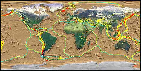
tectonic plates
The U.S. Geological Survey estimates that several million earthquakes occur around the globe every year. Most are too small or too remote to show up in measurements. About 50 measurable earthquakes are recorded every day. In an average year there are 17 major earthquakes (7.0 to 7.9) and one massive one (8.0 or larger).
Lucy Jones, an MIT-educated, Cal-Tech-based science adviser for the U.S. Geological Survey, told Smithsonian magazine: “A magnitude 7 quake happens somewhere in the world every month, a magnitude 6 happens every week.” Many occur in remote or uninhabited regions or under the sea.We pay attention to a disaster like the one that struck New Zealand last year—a 6.3 earthquake near Christchurch that killed 181 people—because, Jones says, it “just happened to be near people. But the earth doesn’t care about that.”
Do small earthquakes release pressure and prevent larger ones? Susan Hough wrote in the Washington Post: In any given area, the numbers of tremors of different magnitudes almost always follow a simple mathematical progression, with about 10 magnitude-6.0 quakes and about 100 magnitude-5.0 quakes for every single magnitude-7.0 quake. Thus, if there is significant strain energy to be released, it must be released in large earthquakes. [Source: Susan Hough, Washington Post, August 26, 2011]
Do Earthquake Occur in Clusters?
Susan Hough wrote in the Washington Post in 2011: “With so many earthquakes in the news recently — such as those in Haiti, Chile and Japan — it seems that the frequency of big temblors is on the rise. Here again, there is an element of truth: Since the magnitude-9.3 Sumatra-Andamans earthquake struck just after Christmas in 2004 and unleashed a tsunami in the Indian Ocean, the Earth has experienced more great quakes, with magnitudes near or above 9.0, than the historical average. [Source: Susan Hough, Washington Post, August 26, 2011]
“Yet the frequency of tremors across the world always fluctuates considerably from year to year. And the energy released by big earthquakes since the end of 2004 was less than the energy released by the two biggest recorded earthquakes: the 1960 temblor in Chile and the 1964 Good Friday quake in Alaska. The number of earthquakes greater than magnitude 7.0has been somewhat high in recent years but well within the range throughout the 20th century.
“A more concerning trend is illustrated by the 2010 Haiti earthquake: This one had a devastating toll despite its relatively modest magnitude because of a prevalence of poorly built structures and a densely packed population. As both population and urbanization expand in developing nations, many more people are in harm’s way. So even if the frequency of quakes is not expected to change significantly, the toll they exact is likely to keep rising.”
Why It Seems Like Earthquakes Occur in Clusters
On the concern that it seems like earthquakes are becoming more common occurrences, Roger Musson wrote in the New York Times: It’s true that more earthquakes are recorded than used to be the case, but that’s simply because there are more monitoring stations that are able to pick up minor earthquakes that once went undetected. If we compare the average global rates of large earthquakes, we find that these are stable as far back as we can trace them. On average, we record an earthquake with a magnitude over 6 every three days or so, and over 7 at least once a month.. [Source: Roger Musson, New York Times, April 10, 2010. Roger Musson is a seismologist with the British Geological Survey.]
“There are two reasons” why it seems earthquakes are happening more frequently. “First, people notice it when earthquakes happen in populated places. A big earthquake in California is news; a big earthquake in the Southern Ocean is noticed only by seismologists. So a run of earthquakes that by chance hit populated places makes it look as though the rate has increased, even if it hasn’t The classic case of this was in 1976. That year, there were a number of high-casualty earthquakes — including a 7.5 magnitude quake in Tangshan, China, that killed more than a quarter of a million people — prompting a lot of news media questions about the increasing frequency of earthquakes. But, in the end, 1976 turned out to have a relatively low number of quakes. It was just that an abnormal number hit populated areas.
“The second reason is that in any semi-random process, you get clustering. Throw enough dice, and sometimes you’ll get several sixes in a row. People notice the clusters; they don’t notice the gaps in between. No one ever asks me during the quiet periods if earthquakes are becoming less frequent. Also, people tend to have short memories; they notice the current cluster, but don’t remember the previous one.
Basic geology explains why the number of earthquakes remains relatively constant. Quakes release a lot of energy, and that energy has to come from somewhere. Ultimately, the source of it is heat released by the steady decay of radioactive material deep inside the earth. For a real long-term increase in earthquake activity, there would have to be an increase in that energy supply, and it’s hard to see how that could happen.
One problem that we do have to face is that our exposure to earthquakes is increasing. As the world becomes more populated and cities grow ever bigger, the potential for quakes to become disasters rises. Tehran, for instance, has been destroyed by earthquakes several times, but it was still quite small at the time of its last damaging quake, in 1830. Now the city is home to millions, and when the next major quake hits, the results will be catastrophic. Unless we devote more effort to protecting communities, the number of earthquake disasters will grow, even if the number of earthquakes stays the same.
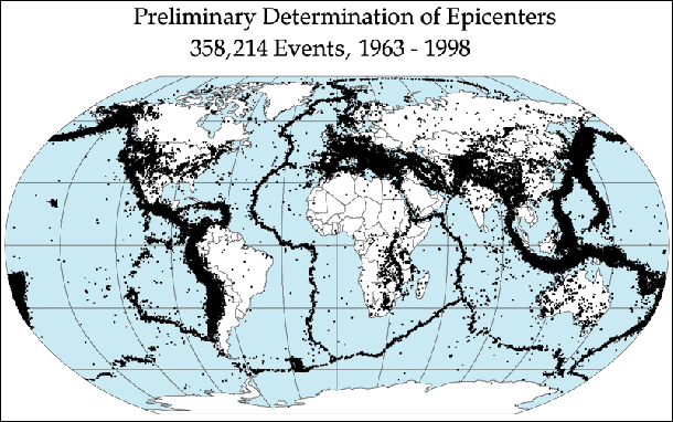
Quake epicenters 1963-98
Surprise Earthquakes
Sometimes earthquakes occur in unlikely places. The magnitude-8.7 Lisbon Earthquake of 1755 killed about 60,000 people, including about 10,000 who died in the quake-triggered tsunami in Lisbon. Two of the most notable quakes in the United States were the 1886 one in Charleston, S.C., and a series of large events centered along the New Madrid Fault of Missouri in 1811-1812. In August 2011, Washington D.C. and other U.S. East Coast cities were shaken by a magnitude-5.9 earthquake centered about 65 kilometers northwest of Richmond. There were no deaths but there were some injuries, damage and building evacuations.
Joel Achenbach wrote in the Washington Post: The March 2011 Earthquake and Tsunami in Japan “wasn’t supposed to be possible. The seismic hazard maps didn’t entertain the idea of a 9.0 magnitude earthquake off the Tohoku coast of Japan. But the Earth paid no heed to scientific orthodoxy. A massive slab of the planet’s crust lurched 180 feet to the east. It rose about 15 feet, lifted the ocean and tipped the Pacific’s waters onto the Japanese coast.[Source: Joel Achenbach, Washington Post, March 9 2012]
“It also humbled the scientific community. Since 2004, earthquake scientists have been caught off guard, or to some extent consternated, by huge killer earthquakes. Scientists were surprised by the location of the 9.1 magnitude earthquake in the Indian Ocean on Dec. 26, 2004, which generated a huge tsunami and took 230,000 lives. That portion of the subduction zone near Sumatra had been considered an unlikely source of a great earthquake.
Since then, more surprises. The 2008 earthquake in China’s Sichuan province, which killed 68,000 people, was in an area that “did not look like a very active region,” American geologist Peter Molnar said afterward. The 2010 earthquake in Haiti occurred along a fault generally considered less dangerous than another fault to the north. And New Zealand has had two significant earthquakes on unmapped faults in the past year and a half. Surprises may be the norm for the seismic future, even in places considered hazard-free. The Virginia earthquake in August, 2012 which damaged the Washington Monument and the National Cathedral, is a reminder that the East Coast could be more vulnerable to tremors than most people realize.
“It is the special challenge of earthquake scientists that they must contend with terrestrial forces that exist outside the frame of human lifetimes, or even the lifetimes of entire civilizations. Some geologic faults may endure thousands of years of strain before a catastrophic rupture. “This is a humbling field. If you want to be smug, don’t be an Earth scientist, and certainly don’t be an earthquake researcher,” said Ross Stein of the U.S. Geological Survey.
“If there’s one obvious change in attitude among geophysicists since Japan’s 3/11 disaster, it’s a recognition that huge earthquakes can potentially happen on any subduction zone — any of the places where one tectonic plate is diving beneath another. For many decades, the presumption had been that some subduction zones were significantly more likely to generate a great quake. As Thorne Lay, a seismologist at the University of California at Santa Cruz, noted in a commentary just published in the journal Nature: “[W]e must allow for the possibility of larger earthquakes in regions where we thought that potential did not exist. That is one difficult lesson that we can consider learned.”
Study of Earthquakes
To study earthquakes scientists break rocks in laboratories to measure stress levels; consult tree rings for clues on ancient tsunamis; dig trenches along faults for signs of pre-earthquake stress; and attach senors to fault zones to get some ideas of what precedes an earthquake. The study of earthquakes as we know it began after the San Francisco earthquake with areal photography of the San Andreas fault and publication in 1908 of the theory of “elastic rebound” which explained the dynamics of earthquakes that fit nicely with theories about plate tectonics that were developed in the 1960s. Using satellite-based synthetic aperture radar (SAR) interferometry scientists can observe ground movements with stunning accuracy during an earthquake. With the help of satellites, aircraft-based LIDAR lasers and global positioning systems (GPS) scientists can accurately monitor specific locations; observe long-term warping and swelling and movement along faults; and detect the slow movements of plates within the thickness of a fingernail.
According to the Los Angeles Times: During the 20th century, improvements in seismic instrumentation and greater use of earthquake-recording instruments (seismographs) worldwide enabled scientists to learn that earthquakes tend to be concentrated in certain areas, most notably along the oceanic trenches and spreading ridges. By the late 1920s, seismologists were beginning to identify several prominent earthquake zones parallel to the trenches that typically were inclined 40-60° from the horizontal and extended several hundred kilometers into the Earth. These zones later became known as Wadati-Benioff zones, or simply Benioff zones, in honor of the seismologists who first recognized them, Kiyoo Wadati of Japan and Hugo Benioff of the United States. The study of global seismicity greatly advanced in the 1960s with the establishment of the Worldwide Standardized Seismograph Network (WWSSN) to monitor the compliance of the 1963 treaty banning above-ground testing of nuclear weapons. The much-improved data from the WWSSN instruments allowed seismologists to map precisely the zones of earthquake concentration worldwide.
Scientists use maps of faults that show areas of high stress in one color and areas of little stress in a different color. After an earthquake the maps have to be redrawn because often stress has been reduced in one some places but is more intense in others. Earthscope is an ambitious $200 million initiative by the National Science Foundation that includes the San Andreas Fault Observatory, the Plat Boundary Observatory, a network of 1,000 GPS receivers at 200 sites along the boundary of colliding plate sin western North America; the United States Seismic Array, a network of seismic stations across the United States; and Interferometric Synthetic Aperture Radar.
Seismic tomography, similar to CT scans, map structures deep in the Earth using measurements of earthquake shock waves.
Drilling Into Faults
To study the physics of earthquake processes, scientists have drilled two miles deep into the San Andreas fault and installed instruments such seismometers, thermal sensors, strainmeters, and fluid pressure transducers that send data to the surface with fiber optic cables. The hole has been bored into a transition area of the fault between an area where small earthquakes occur relatively frequently and an area where larger ones occur less frequently.
The goal is to study places in a fault where the Earthquakes are actually generated. All faults are relatively weak at the surface, The action along them takes place deep in the Earth. The hole goes down vertically for the first 1.4 miles and then angles eastwards towards the fault at 50 degree for another 1.8 miles.
Measurements of temperature, pressure, and chemical composition of minerals are taken. One of the big questions that scientist hope to answer is why rocks in deep in fault sheer under much lower stresses than surface rocks do in the laboratory. Possible explanations for this are: 1) there is something unique about the composition of the rock in the nucleation sites that is different than rocks studied at the surface; 2) water pressure deep underground is higher than expected, creating lubrication that allows the rocks to slip easily. Scientist are asked by journalist all the time if the drilling causes earthquakes. They insist it doesn’t.
Japanese and American scientists are using a drilling ship to bore into the Nankai trough, a subduction zone off the coast of southern Japan, t install instrument at great depths in the hole like those places in the hole at San Andreas Fault. Drilling is scheduled to begin 2007.
Image Sources: Mostly Earthquake Research Institute, University of Tokyo (Japan pictures), USGS (non-Japan pictures) except Tokyo 1923 (J.B. Macelwane Archives, St. Louis University) and Kobe 1995 (Kobe University). Also Wikimedia Commons
Text Sources: New York Times, Washington Post, Los Angeles Times, Daily Yomiuri, Times of London, Japan National Tourist Organization (JNTO), National Geographic, The New Yorker, Time, Newsweek, Reuters, AP, Lonely Planet Guides, Compton’s Encyclopedia and various books and other publications.
Last updated April 2022
