STUDYING GLACIERS

retreat of Grinnell glacier in Glacier National Park
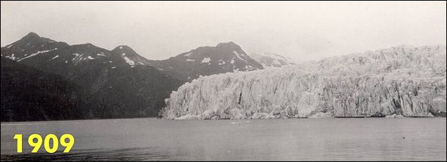
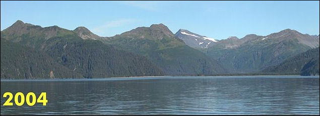
in the U.S. state of Montana. Scientists studying glaciers examine snowfall records and stream flow data; drag ground -penetrating radar over crevasses; analyze soil carbon; and check in animals that live around glaciers. Studying the size and movement of glaciers in the past is difficult because as glaciers move they act like giant erasers, obliterating almost all traces of what happened before. Sometimes the most accurate way to analyze the size of glaciers in the past is to observe old paintings and photographs.
In northern Norway, scientists build temporary caves into the middle of glaciers to study the internal mechanism of glaciers. The caves are dug with warm-water jets. They begin shrinking almost as soon as they are dug and usually collapse within a couple of days. Among the things that scientists have discovered is that bottom of glaciers are filled with water pockets; and friction between sediments in the glacier and rock face is 20 times great than mathematical models predicted.
Scientists in Greenland are drilling deep into continental glaciers there to study climate change, air pollution and other things. The cores reach air pockets and ice that has been trapped for more than 100,000 years. Among the things that scientists have found are ash from the Krakatau explosion, lead pollution from ancient Rome, dust blown from Mongolia and signs that global warming is linked to human intervention.
Scientists study glacier movement dating organic objects found in them such as pieces of wood and plants and analyzing rocks found in deep sediment cores. Scientists are gaining insights into a number of fields by collecting objects that have been revealed as glaciers melts. The Iceman found in 1991 Europe is the most spectacular example of this. Frozen mummies have been found in Peru. Animals of various kinds have been found in glaciers all over the world.
Studying glaciers is often labor-intensive and time consuming. Hundreds of bamboo stakes and poles — often seven meters long — are stuck into the glacier. After a year or so the stakes are checked. The stakes at higher elevations will have snow piled around them and scientists can estimate the amount of snowfall there. The stakes at lower elevations reveal snow melt evaporation. Veteran glaciologist Ian Allison told Reuters, “So you can measure how much height is lowered down below, how much it gained at the top, you’ll need to know the density of the snow and ice as well.” The most carefully studied glaciers are in the Alps.
The process is often hard work. Often the glaciers are hard to reach and the equipment has to be carried in on foot or the backs of horses, mule or yaks. On top of that, especially in the Himalayas, many glaciers are in politically sensitive areas near the borders of India, China, Pakistan or Central Asia . In these places satellite phones and GPS devices are often banned.
Scientists studying glaciers and global warming sometimes carry carbon sensors, sensitive GPS systems and state-of-art, solar-powered weather stations with them on the backs of their pack animals. The teams are not all that different than those used by pioneering mountain surveyors and the first mountaineers to scale the major Himalayan peaks.
See Separate Articles MOUNTAIN GLACIERS AND GLOBAL WARMING factsanddetails.com ; TIBET, THE HIMALAYAS, MELTING GLACIERS AND GLOBAL WARMING factsanddetails.com
Studying Melting Glaciers

Retreat of Helheim Glacier Greenland Scientist are studying the melting glaciers with satellites. Improved satellite imagery and airborne photography and global positioning is making studying remote glaciers easier. This of course yields lots of good data put doesn’t give scientists a close first hand look nor does provide much information of glaciers before the satellites were sent aloft.
Among those who study melting glaciers on foot is Lonnie Thompson, a glaciologist at Ohio State University. As of 2007 Thompson's had been involved in 51 major expedition. J. Madeleine Nash wrote in Smithsonian magazine, “All told, he has spent more than three and a half years at elevations above 18,000 feet. He has endured frostbite and altitude sickness. He rode a Mongolian pony for three days through driving snow and rain on a 1986 expedition to China's Qilian Shan mountains. During a 1993 expedition to Huascarán, the highest mountain in Peru, he crawled across a yawning crevasse on a rickety wooden ladder; camped at 19,800 feet, he was trapped inside a tent as hurricane-force winds carried it toward a precipice. He averted a fall only by stabbing an ice ax through the tent floor.
“Speaking out in the early 1990s, Thompson was one of the first scientists to call the public's attention to glaciers and ice fields as barometers of climate change. He has continued to do so in the years since, reinforcing his message with hard data and before-and-after photographs of disappearing ice fields. Thompson’s speciality is ice-core sampling.
Chinese scientists are busy studying Yulong Snow Mountain, an 18,000-foot peak in southern China's Yunnan province. Barbara Demick wrote in the Los Angeles Times, “Anywhere from five to 20 scientists work here at any given time — planting sticks in the drifts to measure snow accumulation and taking time-lapse photographs of the retreating snows and the advancing tree line up the mountain.” Yulong Snow Mountain is a fitting object for their obsession: It has the southernmost glaciers on the Eurasian continent. Its location at the edge of the Tibetan plateau is also critical. It is the origin of many of Asia's great rivers — among them the Yangtze, the Mekong and Ganges — supplying water to more than 1 billion people. "People are dependent on these glaciers for water and it would have a huge impact on their lives if they disappeared," said He. [Source: Barbara Demick, Los Angeles Times, December 15, 2009]
Ice Core Sampling of Glaciers
Studying ice cores taken from glaciers is a valuable means of gathering information not only about glaciers but also about climate and global warming. J. Madeleine Nash wrote in Smithsonian magazine, “Ice is like a time capsule that preserves the abrupt shifts in climate that have changed the course of human history. From the Quelccaya ice cap — a cap is larger than a glacier — in southern Peru, Thompson and his colleagues pieced together the droughts and floods that unhinged pre-Incan civilizations. In layers of ice cored from the Dasuopu glacier high in the Himalayas, they identified the dusty fingerprints of monsoon failures that have punished the Indian subcontinent with recurrent famine since A.D. 1440. Now Thompson... is using high-altitude ice samples to come to grips with global warming. [Source: J. Madeleine Nash, Smithsonian magazine, July 2007]
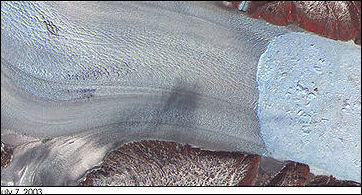
Retreat of Helheim Glacier Greenland “For those who can decipher its arcane script, ice has fascinating stories to tell. Fluctuations in various isotopes, or atomic forms, of oxygen document swings between warm and cold epochs; fluctuations in nitrate levels mark how plants respond to the expansion and contraction of ice. Ice contains bubbles of air from ancient atmospheres and layers of ash from long-ago volcanic eruptions. It contains layers of windblown dust that yield information about broad shifts of precipitation, rising during dry epochs and falling during wet. And ice records shifts of precipitation in the form of thicker and thinner annual layers.”
Thompson's Andean ice, for example, contains ash from known volcanic eruptions, like Huaynaputina's in southern Peru in a.d. 1600. It also incorporates organic detritus that can be radioactively dated. In 1998, Thompson found the remnants of a 6,000-year-old insect in the ice he wrested from a dormant Bolivian volcano. In 2004 and 2005, he recovered 5,200-year-old marshland plants from the Quelccaya ice cap's shrinking edges. Insects and plants near the top of an ice cap or glacier are not so important, since the upper layers bear stripes that reveal the years like tree rings. But establishing dates becomes critical deep in the core, where the weight of overlying ice squeezes annual layers of snow so close together they seem to merge. Just a smattering of independently derived dates from organic material would help nail the Tibetan timelines to the wall.
A wavelike sweep of ice growth proceeding south to north across the Equator bears a striking correspondence to a 21,500-year astronomical cycle. Known as the precessional cycle, it derives from the fact that the earth, like a child's top, wobbles as it spins, altering the time of year in which the Northern and Southern hemispheres come closest to the sun. That, in turn, affects precipitation patterns, including the strength of monsoons.
Studying Melting Himalayan Glaciers in India
The Energy and Resources Institute (TERI) — India’s leading environmental institute’selected three glaciers in 2009 to use as benchmarks to measure, in unprecedented detail, what is happening to the estimated 18,000 glaciers in the Himalayas. Scientists working under Dr Shresth Tayal are is installing high-technology sensors as well as low-take stakes and poles on each of the glaciers in the states of Kashmir, Himachal Pradesh and Sikkim to calculate their precise volume, and the atmospheric conditions affecting them.
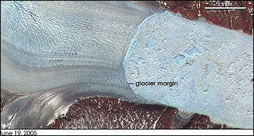
Retreat of Helheim Glacier GreenlandJeremy Page wrote in the The Times, “Inching over the treacherous surface of the Rathong glacier, almost 5,000 meters (16,400ft) high in the eastern Himalayas, Dr Shresth Tayal stooped to inspect a 7m steel rod he buried vertically in the ice six months ago. Tayal on his expedition to install the equipment on the Rathong glacier in Sikkim. “We took it as a challenge when the IPCC said in 2007 there was a lack of data about Himalayan glaciers,” Dr Tayal said. [Source: Jeremy Page, The Times, December 5, 2009]
“After a decade studying Himalayan glaciers, he had expected to find at least half the rod exposed — an alarming enough indication of how fast the Rathong is melting — but even he was surprised by what he found last week. “Six meters in six months,” he cried, breathing hard in the thin mountain air as The Times and the rest of his team stepped gingerly between hidden crevasses and gushing rivulets of freshly melted ice. “It’s pathetic,” he said. “The glacier is dying.”
“Rubbing his hands to ward off the cold, he then tried to fire up a gas-powered drill to plant another 7m rod, but the gas pipe was blocked and with the light fading fast and the clouds rolling in, the team turned back to base camp. But such setbacks are routine for Dr Tayal, one of a handful of intrepid Indian scientists studying a crucial question in the climate change debate: are the Himalayan glaciers disappearing — and with them the biggest fresh water store outside the polar icecaps?”
“The expedition began with a two-hour flight, followed by two days’ drive, then a four-day trek, climbing three vertical kilometers through sub-tropical jungle, alpine forests and barren tundra — all in the shadow of Mount Kanchenjunga, the world’s third-highest peak. His expedition thus included four yaks, four horses, two guides, two cooks and four porters. With satellite telephones banned by the military, if anything went wrong the only options were to improvise — or turn back.”
“To be a glaciologist in India, you have to also be an electrician, mechanic, plumber, engineer.” Dr Tayal said. When he arrived at Rathong he first had to charge a carbon sensor using a motorbike battery, jump leads and a mobile phone charger. Only then could he start assembling a highly sensitive global positioning system and a state-of-the-art weather station. This equipment provides a comprehensive view of atmospheric conditions and a 3-D image of the glacier. Dr Tayal already estimates that Rathong has shrunk by 82 per cent since 1966 and will be gone in ten years because of greenhouse gases, lower precipitation and rising levels of heat-absorbing black carbon or soot.”
“Measuring the lowest point of the glacier is easy enough: a 1966 Survey of India map places it 4 kilometers lower than it is now. But that does not take into account how fast the glacier has been moving downhill. Nor does it indicate its volume, for which its depth must be calculated, or explain the melting. “Think of the glacier as a bucket under a tap, with a hole in the bottom,” said Dr Tayal. “We can now measure how much is coming in, and how much is going out.” The data, is downloaded from the solar-powered sensors once every six months.
McCarty Glacier in Alaska
Studying Melting Himalayan Glaciers in Southwest Tibet
Describing an expedition led by Lonnie Thompson, a glaciologist at Ohio State University, to glaciers around 25,242-foot-high Naimona'nyi is the highest mountain in southwestern Tibet and the 34th highest in the world, J. Madeleine Nash wrote in Smithsonian magazine, “The plan that he has devised with Yao Tandong, director of the Chinese Academy of Sciences' Institute for Tibetan Plateau Research and Thompson's longtime collaborator, is in some ways even more daunting. From our present elevation, about 16,000 feet, they aim to hike another 4,000 feet to the head of a massive ice field in the shadow of Naimona'nyi's highest peak. They will remain there for as long as it takes to drill down to bedrock and extract two or three continuous cores of ice, each hundreds of feet long. [Source: J. Madeleine Nash, Smithsonian magazine, July 2007]
“We wait days for Yao's team to assemble a sufficient number of yaks... Finally, a jangle of bells announces the arrival of a small herd of yaks, bringing the number of pack animals to about 18. The yak herders load our stuff onto the backs of these curious bovines.Then Thompson and his five-member team are off, with Vladimir Mikhalenko, an ice driller from the Russian Academy of Sciences' Institute of Geography, leading the way. Following close behind are chief driller Victor Zagorodnov, glaciologist Mary Davis, graduate student Natalie Kehrwald and geochemist Ping-Nan Lin, all from Ohio State University (OSU). Thompson waves cheerily. "It'll be a walk in the park," he promises.
Half an hour later, I head out... The sharp incline is unrelenting, and I find that I am soon reduced to a rhythm of ten steps followed by a pause in which I suck in an equal number of breaths. In this tortured fashion, I eventually reach 18,400 feet. Thompson is starting the arduous climb to the drilling camp, located high on an ice-filled corridor between two glaciers. He moves steadily but slowly, drawing his breath in ragged gasps. Every now and then he pauses to bend at the waist, as if taking a bow. It's a trick, he says, for easing the burden that high altitude places on the heart. He stops at the top of a tower of rocks deposited by a past advance of ice. Directly below is the glacier he plans to climb.
McCarty Glacier in Alaska
Thompson's team would spend two weeks on the glacier and pull out three cores, one more than 500 feet long (contained in about 140 tubes), representing thousands of years of the glacier's and the atmosphere's history. Then, because their permits had expired, they returned to Lhasa, entrusting their Chinese colleagues with getting the ice off the glacier. It was not an easy task. The first truck hired to haul the cores the 900 miles back to Lhasa never showed up. Porters and yak herders threatened to quit. A two-day snowstorm struck. A second truck choked on the thin air; to keep it running, its drivers had to inject oxygen into the engine from a bottle fetched from Lhasa.
Studying Ice Core Sampling of from Himalayan Glaciers
J. Madeleine Nash wrote in Smithsonian magazine, “About two months after leaving Tibet, I step into the cavernous freezer at OSU's Byrd Polar Research Center. The temperature stands at minus 30 degrees Fahrenheit. Here, stashed on steel shelves, are thousands of shiny aluminum tubes that hold Thompson's collection of ice cores. Organized by expedition, the tubes measure a meter in length; their caps bear an identifying set of letters and numbers. [Source: J. Madeleine Nash, Smithsonian magazine, July 2007]
“My companion, graduate student Natalie Kehrwald, is making a first pass through the Naimona'nyi cores, and even though she's dressed in a wool hat and down jacket, she doesn't linger long in the freezer. Pulling out the tube she wants, she dashes from the freezer to a small anteroom that, mercifully, is some 50 degrees warmer. There she pulls out a cylinder of ice and places it on a light table. This section of the core contains subtly alternating bands of clear and cloudy ice. The transparent bands mark intervals of high precipitation, while the more opaque bands signify drier, dustier times. The pattern is strangely beautiful.”
“Kehrwald examines other lengths of ice. One, from a depth of about 365 feet, is filled with fine air bubbles, which often form under extremely cold conditions. Another, from an even greater depth, contains ice so clear it looks like glass. But it's the ice from closer to the surface that causes the most excitement, for some of it contains intriguing dark flecks that may be fragments of insects or plants — remains that can provide solid rungs in the ladder of time.”
Scientists Studying Tropical Glaciers
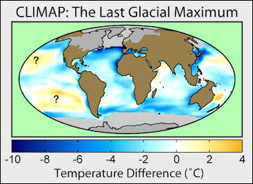
glacial maximum David Fogarty of Reuters wrote: “Scientists have begun drilling ice cores at a shrinking tropical glacier in Indonesia to collect data on climate change, and hope their findings could lead to better predictions about crucial monsoon rains. The team led by alpine glaciologist Lonnie Thompson of Ohio State University is drilling near the summit of 4,884-metre (16,000-foot) Puncak Jaya on Indonesia's part of New Guinea island.
The mountain is the highest in Oceania and the only place in the tropical Pacific with glacial ice that scientists can study to see how the climate has changed over centuries. Thompson said this was probably the last chance to take the ice cores because the tiny glaciers on Puncak Jaya, which have lost 80 percent of their ice since 1936, are melting rapidly. "Our effort is as much a salvage mission to get these records, get whatever they offer and to store some of the ice for the future," he told Reuters from the town of Tembagapura near the mountain during a short break from drilling. "The glaciers have very little time left, much shorter than I thought," he said, adding temperatures at the summit were above freezing and with rain every day that was melting the ice fields.
Glaciers can store long-term records of the climate. Those on Puncak Jaya have layers like tree rings that are the difference between the wet and dry seasons in the tropics, Thompson said. "You can count these layers back through time and you can get a very precise history," he said.
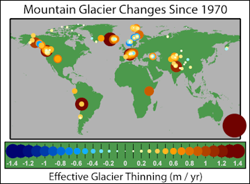
Glacier Mass Balance Map Scientists are particularly interested in finding out more about El Nino. El Nino is a periodic warming of the eastern and central Pacific that can lead to drought in Southeast Asia and Australia and can also affect the monsoon in India while causing floods in parts of South America. Scientists are trying to pin down if global warming will lead to more and stronger El Ninos that could cause more droughts, fires and crop failures in parts of Asia, affecting millions of people and forcing some nations to import more food.
Thompson and his team have so far drilled two cores about 30 metres in length but can't yet say how far back the record goes. He said a 50-metre ice core his team drilled on Kenya's 5,895-metre Mount Kilimanjaro dated back 11,700 years. Thompson has also taken ice cores of Peru's 6,100-metre Nevado Hualcan, on the opposite side of the Pacific. Peru often gets droughts when Indonesia gets wet weather and the idea is to build up a broader set of data covering ice cores, tree rings, corals and other proxies of past climate.
Getting the Indonesian ice cores has proved a vast logical challenge, involve shipping in about four tonnes of equipment, including drills and large ice boxes to store the ice cores to make sure they don't melt on the way to Ohio.
Image Sources: World Meteorological Organization; National Oceanic and Atmospheric Administration (NOAA), Wikimedia Commons
Text Sources: World Meteorological Organization; National Oceanic and Atmospheric Administration (NOAA), New York Times, Washington Post, Los Angeles Times, Times of London, Yomiuri Shimbun, The Guardian, National Geographic, The New Yorker, Time, Newsweek, Reuters, AP, Lonely Planet Guides, Compton’s Encyclopedia and various books and other publications.
Last updated April 2022
