TSUNAMIS IN JAPAN
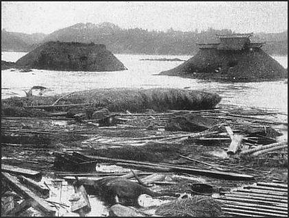
Damage from 1896 tsunami Japan gave the world the word tsunami. A tsunami is a series of waves produced by an event in the ocean such as an underwater landslide or an earthquake that cases large amounts of seawater to be displaced . Sometimes they can be very large. Catastrophic ones occur a few times a century, Other times they are so small they virtually undetectable.
For a long time tsunamis were erroneously called tidal waves. A tidal wave according to Oxford English Dictionary is a “high water wave caused by the movement of the tide.” It is different from a storm surge a flood of water that occur when water pushed inland by a storm such as a typhoon coincides with a high tide. The word tsunami is derived from the Japanese “tsu” (“harbor”) and “nami” (“waves”).
More than 800 tsunamis have been generated in the Pacific in the last century. Some 22 percent of these were generated off of Japan According to geological evidence catastrophic tsunamis like the one that hit Sumatra, Thailand and Sri Lanka in 2004, strike Japan every 400 or 500 years. There have long been worries that a large tsunami on the Pacific coast could kill tens of thousands of people and cause hundreds of billions of dollars in damage. A large earthquake off the east coast of Japan could produce a huge tsunami and people would only have minutes to evacuate even if they are given a warning when the earthquake occurs. This happened in 2011. As bad as it was things could have been worse if a tsunami of that size struck closer to Tokyo or the industrial heart of Japan.
See Separate Articles March 2011 Earthquake and Tsunami factsanddetails.com ; TSUNAMIS: CAUSES, PHYSICS AND DANGERS factsanddetails.com ; TSUNAMIS IN JAPAN factsanddetails.com ; HISTORY OF LARGE TSUNAMIS IN JAPAN factsanddetails.com ; TSUNAMI PREPAREDNESS IN JAPAN: WARNING SYSTEMS, SEAWALLS AND TSUNAMI STONES factsanddetails.com
Good Websites and Sources: Wikipedia article on Tsunamis Wikipedia ; Surviving a Tsunami, Lessons from Chile, Hawaii and Japan pubs.usgs.gov ; Tsunami Warning System in Japan jma.go.jp/jma ; Tsunami Warnings from Japan Meteorological Agency jma.go.jp/en/tsunami ; Book: “Tsunami: The Underrated Hazard” by Edward Bryant. Tsunamis That Struck Japan Major Tsunamis in Japan in the 20th Century tsunami.civil.tohoku.ac.jp ; Major Earthquakes and Tsunamis in Japan in the 20th Century drgeorgepc.com ; 1933 Earthquake and Tsunami pdf file cidbimena.desastres.hn ; 1983 Tsunami drgeorgepc.com ; Report on the 1993 Tsunami nctr.pmel.noaa.gov ; Small Tsunami in 2010 reuters.com
Large Tsunamis in Japan
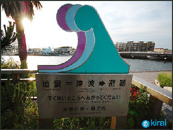
tsunami refuge An earthquake in Tohuku in A.D. 869 is believed to have been the strongest earthquake in historical times. Based on evidence of a tsunami produced by the quake along the Pacific coast it was estimated to have a magnitude of 9 on the Richter scale. About a 1,000 people are thought to have been killed by a tsunami produced by the quake that dumped water three kilometers inland in the Sendai area.
On January 27, 1700, a large tsunami hit a 1,000 kilometer section of Japan’s Pacific coast. It crested at five meters and washed hundred of meters inland and washed up rivers more than two kilometers. The tsunami was generated by a massive earthquake off the American Pacific Northwest coast.
The highest recorded tsunami caused by an offshore earthquake occurred off Ishigaki Island in the Ryukyu chain on April 24, 1771. According to the Guinness Book of Records. it tossed an 830-ton block of coral more than 1½ miles inland and may have been as high as 279 feet.
Unzen, a large volcano on Kyushu near Nagasakai, erupted catastrophically in 1792. An earthquake triggered by the eruption and the collapse of a lava dome sent an entire mountain side sliding into the ocean. The ensuing 100-meter-high tsunami submerged coastal villages, killing about 15,000 people.
Tsunamis engulfed the city of Shimabara with water reaching as far inland as the gates of the city castle. More than 43 square miles of the Shimabara peninsula was covered by water. The waves then traveled across the bay, washing away nearly 6,000 houses and 1,600 fishing boats along another 75-miles section of coastline.
Tsunamis in 1896 and 1933 that struck the northeast coast of Japan around Sanriku killed thousands of people. The one on June 15, 1896 killed 27,120 people in Iwate Prefecture and other areas and occurred after a large earthquake at sea. Fishermen who had been out at sea didn’t eve notice the tsunami when it slipped under their boats. When they returned home they found their villages destroyed and their family members dead or disappeared. There was little warning. The other one was produced by the Sanriku Offshore Earthquake on March 3, 1933, which measured 8.1 on the Richter scale. Most of the 3,008 dead and many of the 7,479 injured were victims of the tsunami.
An 8.2 earthquake in Hokaido in 1952 and an 8 earthquake in 1843 caused tsunamis between four and seven meters (See Tsunamis).
Tsunamis in Japan in Recent Years
In 1960, 100 people were killed and 42 went missing after a tsunami generated by the Great Chilean earthquake struck Japan. That earthquakes measured 9.5 on the Richter scale, the largest ever recorded. The tsunami reached Japan 22 hours after the earthquake occurred.
A tsunami caused by an earthquake in Miyagi Prefecture in northeast Honshu in May 1983 killed 100 people, including a group of elementary school children having picnic on the beach and were swallowed up by a tsunami.
In July 1993, an earthquake hit Okushiri Island, off southwestern Hokkaido. It measured 8.1 on the Richter scale and produced a 10-meter tsunami that washed away many homes and buildings . The tsunami 232 people, destroyed 1,410 houses and caused $500 million in damage. Some victims were killed in high water, landslides and collapsed buildings caused by the tsunami.
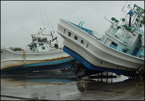
On September 26, 2003, a powerful earthquake struck eastern Hokkaido. Measuring 8.0 on the Richter scale, the quake was located 50 miles off shore and 30 miles below the surface of the sea. A total of 573 people were hurt; 41,000 were evacuated; an oil refinery caught fire; and a train derailed. The main earthquake was followed by a strong earthquake measuring 7.1 on the Richter scale. Much of the damage was caused by a tsunami that reached a height of 1.2 meters in Kushiro in Hokkaido. The tsunami hit about one hour after the earthquake. One man told the Daily Yomiuri, “When a big wave approached the port, I thought it would swallow me and my car whole.”
About two dozen Japanese were killed in Thailand and Sri Lanka by the tsunami in 2004.
In September 2004, a series of powerful under sea earthquakes off of Honshu produced tsunami waves 86 centimeters high in Wakayama. . A powerful and shallow earthquake off of northern Japan produced tsunami waves several centimeters high.
Tsunami Warnings in Japan
Japan has a fairly sophisticated tsunami warning system. Tsunami alerts are issued in television and radio when large earthquakes occur at sea in the vicinity of Japan. More often than not the warnings turn out to false alarms, sometimes very costly ones that cost millions of dollars in lost productivity if a large area is evacuated.
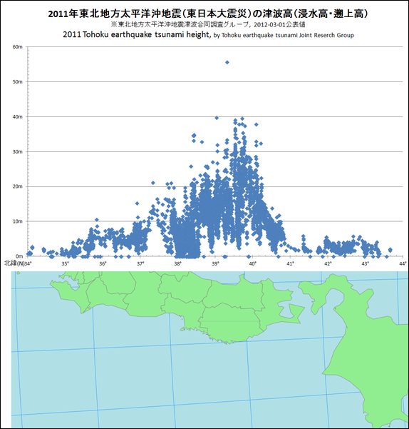
wave heights of the 2011 tsunami in Japan
In November 2006, tsunami warnings were shown repeatedly on televison after an 8.1 earthquake occurred in the Russian-held islands north of Hokkaido. The tsunamis ended up being only a 40 or 50 centimeters high at their highest and few people — even those living in area deemed most dangerous — heeded the warnings and headed for higher ground or shelters. A larger tsunami generated by the same earthquake traveled clear across the North Pacific and produce a 1.8 wave in California and damaged docks and overturned one boat.
In January 2007, an 8.2 earthquake occurred off the coast of Hokkaido about 100 kilometers from the spot 7.9 earthquake occurred in November 2006. . tens of thousands of residents were ordered to seek higher ground in the event of a tsunami. Tsunami warning were issued on television and radio but were widely ignored. The tsunami that hot Hokkaido was only around 20 centimeters high at its highest. It was predicted to be a meter high.
Tsunamis in Japan in Recent Years
According to the Japan Meteorological Agency, the March 4, 1952 Tokachi-oki Earthquake corresponded to a seismic intensity of 8.1. The maximum tsunami height reached 3 to 4m on the Pacific coast f eastern Hokkaido. It caused 28 deaths, injured 287, and destroyed 8,534 houses.
In July 1993, an earthquake hit Okushiri Island, off southwestern Hokkaido. It measured 8.1 on the Richter scale and produced a 10-meter tsunami that washed away many homes and buildings . The tsunami 232 people, destroyed 1,410 houses and caused $500 million in damage. Some victims were killed in high water, landslides and collapsed buildings caused by the tsunami.
On September 26, 2003, a powerful earthquake struck eastern Hokkaido. Measuring 8.0 on the Richter scale, the quake was located 50 miles off shore and 30 miles below the surface of the sea. A total of 573 people were hurt; 41,000 were evacuated; an oil refinery caught fire; and a train derailed. The main earthquake was followed by a strong earthquake measuring 7.1 on the Richter scale. Much of the damage was caused by a tsunami that reached a height of 1.2 meters in Kushiro in Hokkaido. The tsunami hit about one hour after the earthquake. One man told the Daily Yomiuri, “When a big wave approached the port, I thought it would swallow me and my car whole.”
About two dozen Japanese were killed in Thailand and Sri Lanka by the tsunami in 2004.
In September 2004, a series of powerful under sea earthquakes off of Honshu produced tsunami waves 86 centimeters high in Wakayama. . A powerful and shallow earthquake off of northern Japan produced tsunami waves several centimeters high.
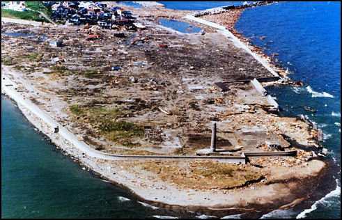
damage from 1983 tsunami in Japan
1983 Sea of Japan Earthquake and Tsunami
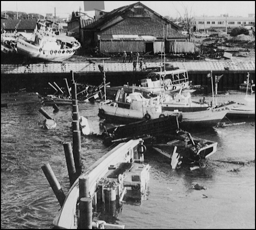
A tsunami caused by an earthquake in Miyagi Prefecture in northeast Honshu in May 1983 killed 100 people, including a group of elementary school children having picnic on the beach and were swallowed up by a tsunami. The tsunami occurred on May 26, 1983, at the middle of the East Sea and propagated across the basin and caused substantial damages along the coasts of Japan and Korea. The tsunami, generated by a magnitude 7.9 earthquake destroyed 700 boats and 59 houses for a total of $800 million in property damage in Japan. A total of 104 people killed or missing in Japan (many drowned in the tsunami) and 324 were injured. Three people were killed in Korea. The earthquake itself damaged 5,100 houses and ended several lives. As a result of the combination of earthquake and tsunami, a process of liquefaction occurred. Liquefaction happens in areas where unconsolidated materials are saturated with water. Under these conditions, what had been a stable soil turns into a fluid that is not capable of supporting buildings or other structures. [Source: History of Tsunamis in Japan, .stfrancis.edu +]
The 1983 Sea of Japan earthquake or 1983 Nihonkai-Chubu earthquake occurred at 11:59am local time. Measuring 7.8 on the moment magnitude scale, it occurred in the Sea of Japan, about 100 kilometers west of the coast of Noshiro in Akita Prefecture, Japan. Out of the 104 fatalities, all but four were killed by the resulting tsunami, which struck communities along the coast, especially Aomori and Akita Prefectures and the east coast of Noto Peninsula. Images of the tsunami hitting the fishing harbor of Wajima on Noto Peninsula was broadcast on TV. The waves exceeded 10 meters (33 feet) in some areas. Three of the fatalities were along the east coast of South Korea (whether North Korea was affected is not known). The tsunami also hit Okushiri Island, the site of a more deadly tsunami 10 years later. [Source: Wikipedia +]
The northwestern side of Honshu lies on the southeastern margin of the Sea of Japan, an area of oceanic crust created by back-arc spreading from the late Oligocene to middle Miocene. The extensional tectonics associated with the spreading formed a series of N-S trending extensional faults and associated basins. Currently the area is being deformed by contractional tectonics, causing inversion of these earlier basins, forming anticlinal structures. It has been suggested that the northwestern coast of Honshu represents an incipient subduction zone, but there remain significant uncertainties about the existence of the Okhotsk Plate and the nature and precise location of its boundary in the Sea of Japan, if it does exist. +
The earthquake lasted for about 60 seconds. The focal mechanism indicates reverse faulting and the distribution of aftershocks is consistent with movement on a thrust plane dipping at 30̊ to the east. The rupture involved two separate faults, the more northerly of which trends NNW-SSE and the more southerly SSW-NNE. The rupture began on the southern fault before continuing on the northern fault after a delay of ten seconds. The maximum perceived intensity was V on the JMA scale (VIII on the Mercalli Intensity Scale). Much of the earthquake damage was due to soil liquefaction, causing the collapse of houses and a number of road and rail accidents. The degree of liquefaction was the worst seen in Japan since the 1964 Niigata earthquake. The greatest effects were observed in areas underlain by loose Holocene aeolian and fluvial sands. Four people were killed by the effects of the earthquake shaking. +
Details of the Tsunami from 1983 Sea of Japan Earthquake and Tsunami
The first wave of the tsunami struck the coast about 12 minutes after the earthquake, with a maximum run-up height of 14.9 meters (49 feet) recorded on the Oga Peninsula. The initial models of the earthquake were unable to reproduce the short time interval between the shock and the first wave arrival at the coast. The possibility that the faults dipped to the west, which would have brought the tsunami source closer to the coast, was inconsistent with seismic data and slow aseismic slip on the southern fault immediately before the mainshock has been proposed as an explanation. [Source: Wikipedia +]
Tsunami deposits associated with this earthquake have been recognised onshore, on the coast and in the Sea of Japan. Offshore both mass failure deposits and turbidites have been observed that are dated to later than 1954 from high Caesium-137 levels in the overlying sediments. +
Tsunami warnings were issued 14 minutes after the earthquake, but many parts of the nearby coast were struck before any action could be taken. Many people were struck by the first wave either on the shoreline or on offshore building sites and there were a hundred deaths. The tsunami caused widespread damage to coastal defences, which had been designed for storms rather than tsunamis. The tsunami reached the coast of South Korea about 1–1½ hours after the earthquake, causing the death of three people. +
1993 Hokkaido Earthquake and Tsunami
On the night of July 12, 1993, their preparations faced a magnitude 7.8 earthquake in the Sea of Japan generated a tsunami that struck various parts of the small island of Okushiri. Five minutes after the main shock the Japan Meteorological Agency issued a warning over television and radio that a major tsunami was on its way. By then, 10- to 20-meter waves had struck the coastline nearest the sources, claiming a number of victims before they could flee. However, 1,200 people escaped the waves when they ran inland after feeling the shaking. [Source: History of Tsunamis in Japan, .stfrancis.edu +]
damage from 1983 tsunami in Japan
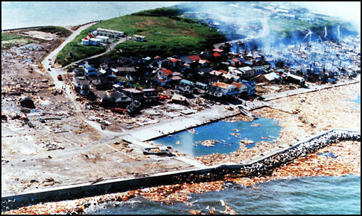
The $600 million in property losses were attributed to the tsunami. This tsunami causes spectacular localized damage, especially on the southwestern shores of Hokkaido and on Okushiri Island. Numerous fires, fueled by above-ground kerosene and propane tanks, broke out following the tsunami, adding to the property loss and misery. The tsunami stripped plants and grasses from the hillside leaving debris in the overhead utility wires. Vertical runup measurements varied between 15 and 30m over a 20km portion of the southern part of Okushiri Island, with several 10m values on the northern portion. As of July 21, 185 fatalities were confirmed, with 120 attributed to the tsunami.
The 1993 Hokkaido Earthquake (Hokkaido- Nansei Oki Jishin) occurred at 1:17pn local time. Measuring 7.7 on the moment magnitude scale with a maximum felt intensity of VIII (Destructive) on the Mercalli intensity scale, it triggered a major tsunami that caused deaths on Hokkaido- and in southeastern Russia, with a total of 230 fatalities recorded. The island of Okushiri was hardest hit, with 165 casualties from the earthquake, the tsunami and a large landslide. [Source: Wikipedia +]
The earthquake occurred in the backarc region of the convergent boundary where the Pacific Plate subducts beneath the Eurasian Plate. The earthquake shaking caused moderately severe damage, VIII on the Mercalli scale. The earthquake had two distinct shocks. The first lasted for 20 seconds, while the second lasted 35 seconds. The rupture occurred on a fault that dipped at 24 degrees to the east. It had an estimated length of 150 kilometers with a displacement of 2.5 meters. The island of Okushiri subsided by 5–80 centimeters. The Okushiri-port landslide involved a volume of 1.5 x 10⁵ m³ of rock. The slide failure occurred at the base of a volcanic breccia bed. The slide occurred in two phases that may match the two separate shocks recorded for the earthquake. +
The tsunami reached Okushiri between 2 and 7 minutes after the earthquake. A tsunami warning was given 5 minutes after the earthquake by the JMA. However, this was too late for the inhabitants of Okushiri. The quake caused fires to start in the town of Okushiri, adding greatly to the total damage. The tsunami inundated large parts of Okushiri, despite its tsunami defenses. Okushiri had been struck by another tsunami 10 year earlier. A maximum run-up of 32 meters was recorded on the western part of the island near Monai. A tsunami was widely observed in the Sea of Japan with a run-up of 3.5 meters at Akita in northern Honshu, up to 4.0 meters in southeastern Russia and up to 2.6 meters on the coast of South Korea. +
The destructive power of this tsunami led to an overhaul of the sea defences on Okushiri involving the construction of tsunami sluices on a river and strengthened embankments. New escape routes were also provided and help was given for households to purchase emergency broadcast receivers. +
Tsunami Caused by Chilean Earthquake in 2010
In February 2010, the Pacific Coast of Japan was struck by a small tsunami generated by a powerful earthquake 17,000 kilometers — half a world away — in Chile that reached Japan the day after the earthquake occurred. The largest tsunami, a 120-centimeter-high surge, was observed at Kuji Port in Iwate Prefecture. A 110-centimeter-high tsunami was seen at Sendai Port in Miyagi and Shibusho Port in Kagoshima Prefecture . Damage was minor: a few building were flooded . Perhaps most remarkably the tsunami traveled 20 kilometers up a river that emptied into Sendai Bay. Tsunami expert Hitoshi Tanaka of Tohuku University told the Yomiuri Shimbun, “In the case of a gently inclining river, a tsunami can travel upriver for long distances and cause flood damage inland. Residents living near rivers have to be careful.”
Tsunami waves generated by the Chilean earthquake kept coming for 20 hours. They were triggered when the seabed and water were raised by a massive amount of energy, created by movement along a 600-kilometer-long fault near Chile.
The greatest damage was suffered by oyster and scallop producers in Miyagi and Iwate Prefectures, where the back surge from the tsunami waves flipped over rafts used to oyster and scallop cultivation. . In some cases the ropes that held the rafts were severed by the tsunami and the rafts floated away. On one group of islands in Miyagi Prefecture , 90 percent of the 180 rafts used to raise nori seaweed were destroyed.
damage from 2003 Hokkaido earthquake and tsunami
The first major tsunami warning in 17 years was issued after the Chilean quake. Advisories, messages and bulletins were broadcast all day long on television with maps showing areas expected to be struck and estimates of the size of tsunamis expected. The Japan Meteorological Agency predicted tsunamis up to three meters in high, which are capable of being quite destructive. In some places train operations were halted and evacuation orders were given. After the event the Japan Meteorological Agency apologized for not only inaccurately predicting the height of waves but also forecasting earlier landfalls than actually occurred.
One survey found that only 6.2 percent of those requested to seek shelter from the tsunami actually did so. Of the 340,000 residents in 36 cities, towns and villages in Aomori, Iwate and Miyagi Prefecture asked to evacuate, only 21,000 sought shelter in designated areas. The others either stayed at home or went somewhere else. On restaurant workers who continued working after the warning was issued told the Yomiuri Shimbun, “The bank here is very high and there’s an evacuation center nearby so we could flee to safety right away if we had to . We were safe when when tsunami caused by [another] Chile earthquake hit here 50 year ago.” Also worrisome was the fact that many of those that did evacuate returned home after the first wave, a dangerous move considering that the most dangerous waves often appear after the first one.
Small Tsunami Hits Japan after 7.3-magnitude Quake
In December 2012, Associated Press reported: “A strong earthquake struck the same Japanese coast devastated by last year's massive quake and tsunami, generating small waves but no immediate reports of heavy damage. Several people along the northeastern coast were reportedly injured and buildings in Tokyo and elsewhere swayed for several minutes. The earthquake had a preliminary magnitude of 7.3 and struck in the Pacific Ocean off the coast of Miyagi prefecture at 5:18 pm, the Japan Meteorological Agency said. The epicentre was 10 kilometers beneath the seabed and 240 kilometers offshore. [Source: Associated Press, December 8, 2012 //\]
“The area was shaken by repeated, smaller aftershocks, the agency said. After the quake, authorities issued a warning that a tsunami potentially as high as 2 metres could hit. Sirens whooped along the coast as people ran for higher ground. Ishinomaki, in Miyagi, reported a tsunami 1 metre high and other towns reported smaller tsunamis. About two hours after the quake struck, the tsunami warning was cancelled. The Pacific Tsunami Warning Centre earlier said there was no risk of a widespread tsunami. //\
Aiko Hibiya, a volunteer for the recovery in Minami-Sanriku, a coastal town devastated by last year's tsunami, said she was at a friend's temporary housing when the quake struck. "It shook for such a long time," she said. Japan has barely begun to rebuild from last year's magnitude-9.0 earthquake, which triggered a tsunami that swelled to 20 meters high in some areas, killing about 19,000 people and displacing over 325,000 people, who now live in barracks and other temporary quarters. Public television broadcaster NHK reported that five people were injured, including a 75-year-old woman in Miyagi who fell while fleeing the tsunami. Police said they could not immediately confirm those reports. //\
In late December 2012, an earthquake with an estimated magnitude of 7.1 on the open-ended Richter scale jolted mainly eastern and northeastern Japan early Saturday, triggering a small tsunami in Pacific coastal areas. [Source: The Japan News, December 26, 2013]
damage from 1983 tsunami in Japan
Small Tsunami Reach Japan from Solomon Quake
A 40-centimeter-high tsunami were observed at Hachijo Island in the Izu chain off Tokyo following an 8.0-magnitude earthquake that rocked the Solomon Islands in the South Pacific, the Meteorological Agency said. A tsunami about 10 centimeters high were also observed at Chichijima in the Ogasawara island chain, at Owase in Mie Prefecture, as well as at Kushimoto and Nachikatsuura, both in Wakayama Prefecture, the agency said. [Source: Kyodo, Jiji, February 7, 2013]
Observation data from other locations along the Pacific coast were mostly within the range of 10 to 20 centimeters or less. The Solomon quake prompted the agency to issue a tsunami alert for Japan’s Pacific coast. At 2:41 p.m., the agency warned that tsunami of up to 50 centimeters high could reach the Pacific coast between Hokkaido and Okinawa. The agency urged people to stay away from the shore and warned that the first tsunami is not necessarily the highest if it originated in a distant location. The powerful earthquake occurred near the Solomon Islands at 12:12 p.m. local time. Tsunami 91 centimeters high were observed in the Santa Cruz Islands.
Image Sources: USGS, Tokyo University, YouTube,
Text Sources: New York Times, Washington Post, Los Angeles Times, Times of London, Yomiuri Shimbun, Daily Yomiuri, Japan Times, Mainichi Shimbun, The Guardian, National Geographic, The New Yorker, Time, Newsweek, Reuters, AP, Lonely Planet Guides, Compton’s Encyclopedia and various books and other publications.
Last updated January 2013
