TIBET AND THE TIBETAN PLATEAU

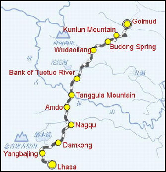
Tibet TIBET is an unworldly place — more intense than it is beautiful — with deep blue skies with low wispy clouds and powerful sunshine; rolling grasslands, dotted with grazing yaks; flat snow-mottled deserts; and yellow, gray and rusty moonscapes with snowy peaks off in the distance. It is also a rough, religious place with fierce dogs, monk-filled monasteries, and nomads who rarely wash. In recent years it has modernized and developed quickly and now has trains that operate on refrigerated tracks, shopping malls and trekkers outfit in US$500 Gortex suits.
Known as the "Rooftop of the World," and the “Land of Snows,” Tibet has long been considered a place of great beauty and mystery. Some of the mystery is rooted in the fact it has traditionally been so darn hard to get and was deepened by the restrictions and prohibition that the Chinese government placed on travel to the area. For centuries Tibet was known as Bod Qiang or Bod. Through most of its history Tibet has been a religious state that coexisted with China under varying degrees of autonomy and control. Since the 1950s it has been under the direct control of Beijing.. Since 1965 it has been administered by the Chinese government as the Tibet Autonomous Region. Areas that traditionally been part of Tibet are now in Qinhai. Gansu, Sichuan and Yunnan. In part because it was so difficult to reach and was off limits to foreigners for so many years many Westerners see Tibet as a mysterious, fascinating place that offers a deeply spiritual way of living than is more meaningful than life in the West.
The Tibetan Plateau, also known as the Qinghai-Tibetan Plateau, occupies most of Tibet, Qinghai, and western Sichuan. It is mostly above 3,000 meters. Norma Diamond wrote in the “Encyclopedia of World Cultures”: “ Barley, buckwheat, and some wheat are grown in the southeastern valleys, while pastoralism (raising yaks, sheep, goats, and horses) is widespread in Qinghai and western Tibet. Traditional trade routes from Tibet to Nepal and India, closed in 1949, have only recently been reopened. Rich mineral deposits are only beginning to be discovered and exploited. Poor communication routes to inner China have helped to make this the poorest region in the country. Population density is low, there are few urban centers, and most of the population is non-Han. Besides the large Tibetan population, the minorities include Hui, Lhoba, Moinba, Qiang, Sala (Salar), and Tu. [Source: “Encyclopedia of World Cultures Volume 6: Russia-Eurasia/China” edited by Paul Friedrich and Norma Diamond, 1994 |~|]
The population of Tibet was 3,648,100 in 2020; 3,002,166 in 2010; 2,616,329 in 2000; 2,196,010 in 1990; 1,892,393 in 1982; 1,251,225 in 1964; 1,273,969 in 1954. [Source: Wikipedia, China Census]
Web Sites: Wikipedia Wikipedia Tibetan Resources columbia.edu/cu/lweb/indiv/eastasian/Tibetan/links ; Photos: Tibet Photo Gallery Tibet Gallery Terra Nomada Terra Nomada Tourist Office: Tibet Tourism Bureau, 18 Yuanlin Rd, 850001 Lhasa, Tibet China, tel. (0)-891-633-5472, fax: (0)- 891-633-4632 Maps of Tibet (Xizang): chinamaps.org
RECOMMENDED BOOKS: "Tibetan Civilization" by Rolf Alfred Stein Amazon.com; “Tibet an Account of the History, the Religion and the People of Tibet” by Colin M. Norbu, Thubten Jigme and Turnbull Amazon.com; “From a Mountain In Tibet: A Monk’s Journey” by Yeshe Losal Rinpoche Amazon.com; “The Story of Tibet: Conversations with the Dalai Lama” by Thomas Laird Amazon.com; “Tibet, Tibet: A Personal History of a Lost Land” by Patrick French Amazon.com; “Tibet: My Story : An Autobiography” by Jetsun Pema and Gilles Van Grasdorff Amazon.com; “Land of Pure Vision: The Sacred Geography of Tibet and the Himalaya” by David Zurick and Eric Valli Amazon.com; Amazon.com; “A Historical Atlas of Tibet” by Karl E. Ryavec Amazon.com; Travel: “Lonely Planet Tibet 10 by Stephen Lioy , Megan Eaves , et al. (2019) Amazon.com; “Tibet: A Travel Survival Kit (Lonely Planet Tibet) by Robert Strauss (1992) Amazon.com; “Tibet: An Inner Journey” by Matthieu Ricard Amazon.com; “Tibet: The Secret Continent” by Michel Peissel Amazon.com
Tibet Autonomous Region
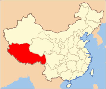
Tibet is officially called the Tibet Autonomous Region (TAR) and sometimes referred to Xizang or the Xizang Autonomous Region or Zang for short. Tibet is not a province but is province-level autonomous region of the People's Republic of China (PRC). It was created in 1965 on the basis of Tibet's absorption into the PRC in 1951. The current borders of Tibet were generally established in the 18th century and includes about half of ethno-cultural Tibet. Vast expanses of TAR are uninhabited by humans. mostly due to its harsh and rugged terrain,
Tibet Autonomous Region is the second largest province-level division after Xinjiang and the least densely populated one. It covers 1,228,400 square kilometers (474,300 square miles) and has a population density of three people per square kilometer. According to the 2020 Chinese census the population was around 3.6 million. About 31 percent of the population lives in rural areas. Lhasa is the capital and largest city, with about 900,000 people. Ethnic Tibetans make up 90 percent of the population of Tibet, followed by Han Chinese (8 percent); Monpa (0.3 percent); Hui (0.3 percent); others (0.2 percent).
Like Chinese provinces, an autonomous region has its own local government, but an autonomous region — theoretically at least — has more legislative rights. An autonomous region is the highest level of minority autonomous entity in China. They have a comparably higher population — but not necessarily a majority — of the minority ethnic group in their name. Some of them have more Han Chinese than the named ethnic group. There are five province-level autonomous regions in China: 1) Guangxi Zhuang Autonomous Region for the Zhuang people, who make up 32 percent of the population; 2) Inner Mongolia Autonomous Region (Nei Mongol Autonomous Region) for Mongols, who make up only about 17 percent of the population; 3) Tibet Autonomous Region Autonomous Region (Xizang Autonomous Region) for Tibetans, who make up 90 percent of the population; 4) Xinjiang Uyghur Autonomous Region, for Uyghurs, who make up 45.6 percent of the population; and 5) Ningxia Hui Autonomous Region, for the Hui, who make up 36 percent of the population. [Source: Wikipedia]
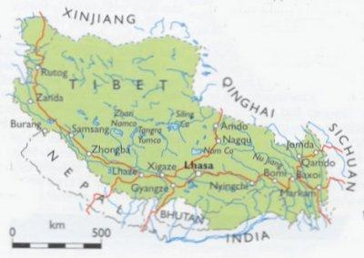
Administratively, Tibet Autonomous Region is divided into one municipality and six prefectures. The municipality is Lhasa, while the six prefectures are Shigatse, Ngari, Shannan, Chamdo, Nagchu and Nyingchi. These are further divided into counties. With nearly 4,000 kilometers of international bounders it marks much of China's southwest barrier. Within China, Tibet is divided from Xinjiang by the Kunlun mountains and from Qinghai Province by the Tanggula Mountains. Sichuan Province lies across the Jinsha River.
Geography of Tibet

map of Tibet Tibet is about twice the size of Texas or twice the size of France and makes up one-eighth of the total area of China. Most of it is covered by a high, wind swept plateau — the Tibetan-Qinghai Plateau (See Below) — that receives little rain and is bitterly cold in the winter. It is separated from Nepal, India and Burma by the Himalayas, which include Mt. Everest.
Tibet is bordered by Xinjiang (Xinjiang Uyghur Autonomous Region, XUAR) to the north, Qinghai province to the northeast. Sichuan Province to th east. There is also a short border with Yunnan province to the southeast. To the south are countries of India, Myanmar, Bhutan and Nepal. China has border disputes with India over the McMahon Line of Arunachal Pradesh, known to the Chinese as "South Tibet". The disputed territory of Aksai Chin is to the west, and its boundary with that region is not defined.
See Separate Article GEOGRAPHY AND WEATHER OF TIBET factsanddetails.com
World's Highest Places in Tibet
According to the Guinness Book of Records, Tibet boasts 1) The highest trail in the world is an eight-mile section between Khaleb and Xinji-fu, Tibet. There are two parts that exceed 20,000 feet. 2) A settlement on the T'e-li-mo trail (southern Tibet) is the world's highest settlement. It is 19,800 feet high.
3) Wenzhuan (Tibet) is the world's highest town. Founded in 1955 on the Quinghai-Tibet road north of the Tangla road, it is 16,730 feet high. 4) Jiachan is 15,870-foot-high and listed in the Guinness Book of World Records are the world's highest inhabited town. 5) Yarlung Tsangpo Valley is the world's deepest valley. According to the Guinness Book of Records, it is 16,650 feet deep and is between the peaks Namche Barwa (25,536 feet) and Jala Peri (23,891 feet), which are 13 miles apart with the Yarling Tsangpo River in between.
The world’s five highest airports are in Tibet or the Tibetan part of Sichuan:
1) Daocheng Yading Airport in Daocheng, Sichuan at an elevation of 4,411 meters (14,472 feet);
2) Qamdo Bamda Airport in Qamdo, Tibet at an elevation of 4,334 meters (14,219 feet);
3) Kangding Airport in Kangding, Sichuan at an elevation of 4,280 meters (14,042 feet);
4) Ngari Gunsa Airport in Shiquanhe, Tibet at an elevation of 4,274 meters (14,022 feet);
5) Garze Gesar Airport in Garzê, Sichuan at an elevation of 4,068 meters (13,346 feet)
Tibetan Climate
 Tibet is sometimes called the "Land of the Snows" even though it snows relatively infrequently. Tibet receives 46 centimeters of precipitation or less a year. Wind is constant and the air is very dry. Tibetans often wrap a bandanna or shawl around their mouths for protection against windblown sand and dust. The best time to travel to Tibet is June through October. Other times of the year it is too cold. June and July are often rainy in eastern Tibet.
The temperatures frequently drop below minus 30̊F in the winter and sometimes rise above 100̊F in the summer. The temperature can drop 80̊F in a single day, and the extremes of hot and cold are enough to break up the granite mountains into dust and sand, and release fierce winds, stinging hailstorms, and blinding dust storms. It is no surprise many Tibetans believe that hell is a bitterly cold place not an inferno.
I couldn’t believe how warm it was when I visited Tibet in December and January. It was a little unreasonably warm when I was there but not much. In Lhasa, which has the same latitude as Florida, it was generally in the 50s F during the day, dropping into the 20s at night. I brought a huge backpack with polypropylene underwear, a thick, fishermen’s knit sweater and various kinds of gloves and glove covers I didn’t need in Lhasa. However, it was quite cold in the Everest area. There was not heat in my hotel room and I slept with my down jacket on and hot water bottles. At my hotel in Lhasa, there was plenty of heat from a radiator.
See Separate Article GEOGRAPHY AND WEATHER OF TIBET factsanddetails.com
History and People of Tibet
The first people showed up about around 30,000 years ago. Tibetans first settling in numbers along the middle reaches of the Yarlung Zangbo (Brahmaputra) River and its tributaries marks the beginning of Tibet. At the beginning of the 7th century, King Songzan Gambo established a kingdom known as "Tubo" ("Bo"). After the Tubo regime was established, the Tibetans increased their political, economic, and cultural strength and had exchanges with the Han Chinese and other ethnic groups in China. In 641, King Songzan Gambo married Princess Wencheng of the Tang Dynasty (618-907). From the 10th to 12th century, Tibet split into several independent regimes. The Mongols, who established the Yuan Dynasty (1279-1368) in China had close relations with Tibet.
Before the 18th century no outsiders bothered too much with Tibet. In the 18th and 19th century it was taken over by China. In 1911, Tibet gained independence again but China reclaimed it 1951 and sealed it off from the rest of the world for more than two decades after a Tibetan uprising in 1959 and the escape of the Dalai Lama and 100,000 Tibetans to India.
About 3.5 million people live in Tibet live in Tibet Autonomous Region, of which about 90 percent are Tibetans. Another four million Tibetans live in the provinces adjacent to Tibet Autonomous Region. Parts of these province were once part of Greater Tibet. Tibetan society was largely feudal until the Chinese abolished serfdom in 1953. The non-Tibetan population include permanent Chinese residents, a "floating population" of Chinese entrepreneurs, many of them of Sichuanese and Muslim Huis, and Chinese soldiers and paramilitary troops.
Tibet has traditionally been one of the poorest and least educated regions in China. Chinese leaders have recently made an effort to improve the living standards of Tibetans, and boost tourism to help local people make money, but many Tibetans are suspicious of Chinese intentions and wish they would go away and leave Tibet to Tibetans. They are especially critical of efforts to destroy and suppress Tibetan culture, the horrible treatment of the Dalai Lama, and the mass migration of Han Chinese to Tibet.
Regions of Tibet
There are four traditional provinces of Tibet: 1) Amdo in the north-east, now largely occupied by Qinghai Province; 2) the Kham in the east, now occupied by western Sichuan and eastern Tibet Autonomous Region; 3) Ngari (including former Guge kingdom) in the north-west; and 4) Ü-Tsang (or Tsang-Ü) in southern and central .
Amdo encompasses a large area stretching from the Yellow River to the Yangtze, embracing much of modern-day Qinghai Province. The region was historically, culturally, and ethnically a Tibetan area and has been ruled by local rulers since the mid-18th century and presided over but not ruled directed by the Dalai Lamas. There are many dialects of the Tibetan language spoken in Amdo due to the geographical isolation of many groups. Amdo is featured in a famous epic story known to both Tibetans and Chinese and traditionally been regarded as place where magnificent horses were raised and allowed to run wild.
Kham is the wild Tibetan area in Sichuan, Yunnan and eastern Tibet that is very different from the dry and brown Tibetan plateau. A lush and green and well-watered place, Kham features old growth forests, rhododendron trees and spectacular mountains and Alpine scenery. Antelopes, golden eagles, packs of green parakeets, snow leopards, bears, monkeys and wolves and bandits still roam here. The roads here have only recently been opened to tourists and many places are still off limits. Kham is different from Tibet in other ways. The Khampa Tibetans live wood or stone houses with brilliantly carved windows not concrete or mud brick houses or yak-hair tents as is the case on the Tibetan plateau. There is not a large Han Chinese presence here other than police and soldiers. Some Han Chinese here have even married Tibetans. There region has long had a reputation unruliness and
Ngari Prefecture is located in the western part of Southwest China's Tibet autonomous region, at the center of the Changtang Plateau on the northern part of the Tibetan Plateau. It begins at Zhamai Mountain, west of the Tanggula Mountains, in the east, bordering the Nagqu Prefecture, and stretches to the western section of the Himalayas in the west and southwest, bordering India and Nepal. It joins the middle section of the Kangdese Mountains, neighboring the Shigatse Prefecture's Zongba and Sagar counties, and ends on the southern side of the Kunlun Mountains in the north, neighboring Xinjiang Uygur Autonomous Region. The border totals 1,116 kilometers with 57 passageways linking the area to other places. [Source: chinaculture.org, Chinadaily.com.cn, Ministry of Culture, P.R.China]

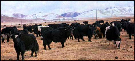
Yaks and yak-cow hybrids
Ü-Tsang
Ü-Tsang (or Tsang-Ü) is the cultural heartland of the Tibetan people. It covers south-central Tibet and includes the Brahmaputra River watershed and the Lhasa and Shigatse areas. The Himalayas defined Ü-Tsang's southern border. The present Tibet Autonomous Region corresponds approximately to what was ancient Ü-Tsang and western Kham. [Source: Wikipedia]
Ü-Tsang was formed by the merging of two earlier power centers: Ü (dbus) in central Tibet, controlled by the Gelug lineage of Tibetan Buddhism under the early Dalai Lamas, and Tsang (gtsang) which extended from Gyantse to points west, controlled by the rival Sakya lineage. Military victories by the powerful Khoshut Mongol Güshi Khan that backed 5th Dalai Lama and founded Ganden Phodrang government in 1642, consolidated power over the combined region, followed by the rule of the Qing Dynasty started in 1720 by the Qianlong Emperor that continued until the British expedition to Tibet (1903–1904).
Tsang, whose largest cities are Gyantse and Shigatse, near where the Panchen Lama has his traditional seat at Tashilhunpo Monastery, was designated on maps of the Qing dynasty as "Back Tibet", while Ü, where the Dalai Lama has his seat at Lhasa, was designated "Front Tibet". This division was an artificial construct of the Chinese and had no currency within Tibet where the Dalai Lama exercised effective rule over both Tsang and Ü.
Making the Tibetan Plateau the World’s Biggest National Park?
In 2017 China announced plans to turn the entire Tibetan plateau in a national park, in the process creating the world’s biggest national park by A survey to help draw boundary of 2.5 million square-kilometers (965, 250 square-mile) park — roughly the size of Tanzania — began in the summer of 2007 [Source: Stephen Chen, South China Morning Post, April 22, 2017]
Stephen Chen wrote in the South China Morning Post: China is considering turning the entire Tibetan plateau and surrounding mountains into a huge national park to protect “the last piece of pure land”, according to scientists briefed on the project. Dubbed the Third Pole National Park because the plateau and mountains, including the Himalayas, have a natural environment that in many ways resembles polar regions, it would be the world’s biggest national park. The plateau covers an area of more than 2.5 million square kilometers, mainly in Tibet and Qinghai, dwarfing the biggest national park at present, Greenland’s 972,000 square kilometers Northeast Greenland National Park.
“In summer of 2017, the Chinese government launched the biggest scientific survey of the Tibetan plateau, with a large number of scientists from China taking part, accompanied for the first time by others from neighbouring countries such as Nepal and Pakistan. The researchers were assisted by advanced research equipment including drones and new earth-observation satellites. One important mission of the survey will be to help draw the boundary of the new national park, according to some researchers preparing for expeditions.
“But the project’s feasibility has been questioned. Professor Liu Jingshi, researcher with the Chinese Academy of Sciences’ (CAS) Institute of Tibetan Plateau Research, said the Third Pole National Park, if established as proposed, would be difficult to manage due to its unprecedented size. He said it took the United States government decades to figure out how to manage Yellowstone, the world’s first national park, which was established in 1872. The Third Pole would be more than 250 times larger, with a much more sophisticated natural landscape. “It is too big for a park,” Liu said.
“And unlike the unpopulated park in Greenland, the Tibetan plateau is home to cities, towns and nomadic tribes, with native Tibetan population estimated at 7.8 million. The main purpose of a national park is conservation, which would limit a wide range of economic activities and might necessitate the relocation of some residents. “Some people will lose their jobs. The lives of many may be affected,” said Professor Yi Chaolu, another researcher with the Institute of Tibetan Plateau Research. “To establish the park or not may go beyond science. It is also a political issue.” The Tibetan plateau is also rich in natural resources, but establishing a national park would mean an end to most, if not all, mining.
Image Sources: Seat 61, Wikimedia Commons, Nolls China Web site; CNTO; Perrochon photo site; Beifan.com; University of Washington; Ohio State University; UNESCO; Wikipedia; Julie Chao photo site
Text Sources: CNTO (China National Tourist Organization), China.org, UNESCO, reports submitted to UNESCO, Wikipedia, Lonely Planet guides, New York Times, Washington Post, Los Angeles Times, National Geographic, China Daily, Xinhua, Global Times, The New Yorker, Time, Newsweek, Bloomberg, Reuters, Associated Press, AFP, Compton's Encyclopedia and various books and other publications.
Updated in September 2022
