TOWNS AND CITIES IN ANCIENT EGYPT

ANCIENT EGYPTIAN CITIES AND TOWNS


With few exceptions, villages, towns and cities were set up on the Nile, which was the main transportation route and the main source of water for drinking and agriculture. There were streets in the towns. They generally were not paved.

Cities and large towns had separate districts where glassware was produced, textiles were made, cattle were kept and pigs were slaughtered. The nicest neighborhoods were near the pharaoh’s or the governor’s palace. Agricultural fields were often mixed in with houses, which tended to clustered together so as not to waste land.

Large cities in the Near East in the third millennium B.C. had only around 20,000 people. Later they got bigger, Memphis, the capital for much of Egypt’s ancient history, covered 20 square miles at its largest in about 300 B.C. , with a population of around 250,000. Today most of it lies under the village of Mit Rahina and fields that surround it.

In towns and cities "granaries, breweries, carpenters and weavers shops were attached modular fashion to households." Smelly fish-processing and smokey bakeries were usually on the northwest, downwind side, of the households.

Websites on Ancient Egypt: UCLA Encyclopedia of Egyptology, escholarship.org ; Internet Ancient History Sourcebook: Egypt sourcebooks.fordham.edu ; Discovering Egypt discoveringegypt.com; BBC History: Egyptians bbc.co.uk/history/ancient/egyptians ; Ancient History Encyclopedia on Egypt ancient.eu/egypt; Digital Egypt for Universities. Scholarly treatment with broad coverage and cross references (internal and external). Artifacts used extensively to illustrate topics. ucl.ac.uk/museums-static/digitalegypt ; British Museum: Ancient Egypt ancientegypt.co.uk; Egypt’s Golden Empire pbs.org/empires/egypt; Metropolitan Museum of Art www.metmuseum.org ; Oriental Institute Ancient Egypt (Egypt and Sudan) Projects ; Egyptian Antiquities at the Louvre in Paris louvre.fr/en/departments/egyptian-antiquities; KMT: A Modern Journal of Ancient Egypt kmtjournal.com; Ancient Egypt Magazine ancientegyptmagazine.co.uk; Egypt Exploration Society ees.ac.uk ; Amarna Project amarnaproject.com; Egyptian Study Society, Denver egyptianstudysociety.com; The Ancient Egypt Site ancient-egypt.org; Abzu: Guide to Resources for the Study of the Ancient Near East etana.org; Egyptology Resources fitzmuseum.cam.ac.uk

Egyptian Urban Centers

Since the 1980s excavations have uncovered urban remains that have debunked conventional ideas that the Egypt of the pharaohs, in contrast to Mesopotamia, was somehow a civilization without cities. “We can now confirm that this was not the case,” Nadine Moeller, an Egyptologist at the Oriental Institute of the University of Chicago, told the New York Times. [Source: John Noble Wilford, New York Times, July 1, 2008]

Moeller described the discovery of a large administration building and seven grain silos buried at the site of an ancient provincial capital on the Upper Nile. The partly preserved round silos, more than 3,500 years old, appear to be the largest storage bins known from early Egypt. Seal impressions and other artifacts associated with commodities put a somewhat older date for the central building, with at least 16 columns.

20120215-Karnak_Temple_Map.jpg
Karnak temple map
“This is a really amazing site, at the cutting-edge of recent Egypt archaeology,” Stuart Tyson Smith of the University of California, Santa Barbara told the New York Times. “Digging into towns, you get the full range of life, not the very narrow view of society as seen from the top, from the rich and elite.” Mark Lehner, an Egyptologist who uncovered remains of settlements for workers who built the pyramids at Giza, said that at Dr. Moeller’s site he inspected layers of sediments showing occupation extending back 5,000 years to the dawn of Egyptian civilization and forward to the early Islamic period in the first millennium A.D. The silos are near temple ruins from about 300 B.C. “Where there are temples, we are learning, they were surrounded by towns which have usually been overlooked,” Dr. Lehner said.

John Noble Wilford wrote in the New York Times, “The site of the recent discovery is at Tell Edfu, halfway between the modern cities of Aswan and Luxor (Thebes in antiquity). For much of Egyptian history, the central government was based in Memphis, in the north, or Thebes. The town at Tell Edfu was an important regional center with close ties to Thebes.Dr. Moeller and a team of European and Egyptian archaeologists began excavations near the temple there in 2005. They exposed a large courtyard surrounded by mud-brick walls. Underneath the courtyard, they came upon foundations of the first three of the seven silos. From artifacts, the archaeologists dated the silos to the 17th dynasty, 1630 to 1520 B.C.

These storage bins, presumably for barley and emmer wheat, which were used for food and as a medium of exchange, were built of mud brick, with diameters from 18 to 22 feet. If their height was greater than the diameter, as was the usual case, the silos probably stood at least 25 feet tall. “Their size was a surprise, nothing we had encountered before, certainly not in a town center,” Dr. Moeller said.

In the last three years, the team excavated the column bases and chambers of what they think was the town’s administrative center. The building layout suggests it may have been part of the governor’s palace, and artifacts mark it as the economic heart of town.

Seal impressions, which established the building’s existence in the 13th dynasty, 1773 to 1650 B.C., indicate their use in identifying different commodities. Some seals showed ornamental patterns of spirals and hieroglyphic symbols belonging to different officials. Archaeologists said this was evidence of the activities in the building like accounting and the opening and sealing of boxes and ceramic jars in the course of business transactions.

“The work at Edfu is important in that it allows us to examine ancient Egypt as an urban society,” said Gil Stein, director of the Oriental Institute. As a specialist in Mesopotamian archaeology, Dr. Stein noted the longstanding assumption that the valley of the Tigris and Euphrates Rivers was “a land of cities and Egypt was something else, because in Egypt we had not been looking at or for cities.”

Memphis

Memphis (18 miles southwest of Cairo) is oldest capital of ancient Egypt. Founded around 3000 B.C. by King Menes on land reclaimed from the Nile, it was selected as a site for the capital because it was located between Upper Egypt and Lower Egypt at a place where the Nile Valley narrows to less than a mile across, and travel between the northern and southern Egypt could be controlled.

Memphis was the capital for much of ancient Egypt’s history. For a long time it was the administrative capital of the ancient Egyptian empire while Thebes was the religious center. The Pharaohs spent much of his time in Memphis and visited Thebes only during special religious ceremonies.

20120215-Lepsius-Projekt_tw_1-1-16.jpg
Pyramid layout near Memphis

When Memphis was at its largest around 300 B.C. it covered 20 square miles and had a population of around 250,000. Today most of it lies under the village of Mit Rahina and fields that surround it. Memphis was once on the Nile but the now the river is some distance away. Nearly all of the great buildings that once stood in Memphis have been lost to time.

The Memphis Museum contains a huge 30-foot-long reclining Colossus of Ramses the Great that weights 120 tons and is made of fine-grained limestone. Childless women still walk around the statue seven times in the belief it will make them pregnant. Some women reportedly have even climbed on statue and simulated the movements of love making. The Temple for Embalming the Sacred Apis Bull shows how to embalm a bull. Situated in a grove of palm trees is the Alabaster Sphinx of King Tuthmosis III. In the area is the necropolis of the Apis bulls (Serapeum), which contains 24 granite sarcophagi, each weighing over 60 tons.

Abydos in the New Kingdom

Abydos was another early city that declined and was reborn under Ahmose (1550-1525 B.C.) in the early New Kingdom. Cliffs around Abydos drops to the Nile flood plain and desert. New Kingdom sites include the remains of the last royal pyramid, built by Ahmose (1550-1525 B.C.), and remnants of a structures with scenes from Ahmose’s battle victories. In the a huge necropolis nearby archeologists discovered the Tablet of Abydos, which contains the names of Egyptian kings from Menes (the first great pharaoh) to Seti I. This long list of inscriptions helped scholars figure out the sequence of pharaohs starting with the first Egyptian kings.

The Temple of Seti I (1306-1290 B.C.) is one of the best preserved Pharaonic buildings in Egypt. Also known as El Balyana, it is painted and honors seven gods, including Orisis and the deified Seti I, and was constructed under Seti I and Ramses II. The Temple of Seti is best known for its detailed bas-reliefs and murals painted by the ancient Egyptians, Greeks and Romans. The temple includes two hypostyle halls. The second one contains a forest of pillars and the best murals. A row of seven small chapels in the second hypostyle hall contains scenes of Seti I and various deities.


Abydos


Thebes (Luxor): the Home of Ancient Egypt's Great Temples

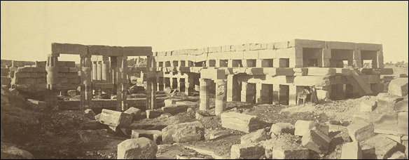
Present-day Luxor (500 kilometers south of Cairo) was the site of ancient Thebes and is home to the greatest concentration of ancient monuments in Egypt: the magnificent temples of Karnak, Luxor and Hatshepsut , the Valley of the Kings, the Valley of the Queens, the tomb of Tutankhamen, and the Colossi of Memnon, the giant broken statues of Ramses the Great that inspired Shelley's poem “Ozymandias”. From 2,100 to 750 B.C., Thebes was the religious capital of Pharonic Egypt and the center of Egyptian power. It embraced the area occupied by Karnak and Luxor. The priests who worked out of the temples became so powerful they were regarded as a threat to the pharaoh.

Thebes emerged as the main power center of Egypt at the dawn of the Middle Kingdom (2125 to 1520 B.C.) and became the capital of Egypt after the Hyksos were kicked out of Egypt. During the New Kingdom (1539 to 1075 B.C.) it was the center of Egypt. The pharaohs resided here and perhaps 1 million people lived in the area. The largest and most spectacular building were built during the reigns of Amenhotep III and Ramses II in the 14th and 13th century B.C. By Greco-Roman times it was already major tourist attraction. Pilgrims continued going to Karnak Temple to around A.D. 100.

Thebes (Waset, in ancient Egyptian) was the City of a Hundred Gates. It was the capital of Egypt beginning in the twelfth dynasty (1991 B.C.) and reached its zenith during the New Kingdom. Mark Millmore wrote in discoveringegypt.com: “It was from here that Thutmose III planned his campaigns, Akhenaten first contemplated the nature of god, and Rameses II set out his ambitious building program. Only Memphis could compare in size and splendor but today there is nothing left of Memphis: It was pillaged for its masonry to build new cities and little remains. Although the mud-brick houses and palaces of Thebes have disappeared, its stone temples have survived.” [Source: Mark Millmore, discoveringegypt.com discoveringegypt.com]

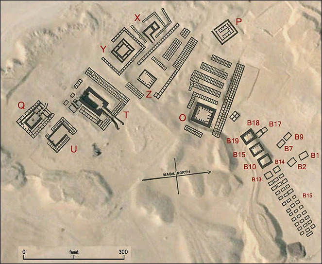
Elaine Sullivan of UCLA wrote: “The ancient city of Thebes (or Waset as it was known in Egyptian) played an important role in Egyptian history, alternately serving as a major political and religious center. The city’s tombs, including those in the Valley of the Kings and the Valley of the Queens, are located on the west bank of the Nile, in the area’s limestone cliffs. The mortuary temples of many of the New Kingdom kings edge the flood plain of the Nile. The houses and workshops of the ancient Thebans were primarily located on the river’s east bank. Little remains of the ancient settlement, as it is covered by the modern city of Luxor. A series of important temples, composing the religious heart of Thebes, constitutes most of what remains today. To the south, close to the banks of the Nile, lies the Temple of Luxor. To the north, joined to Luxor by a sphinx- lined avenue, stand the temples of Karnak. Karnak can be divided into four sections: south Karnak, with its temple of the goddess Mut; east Karnak, the location of a temple to the Aten; north Karnak, the site of the temple of the god Montu; and main/central Karnak, with its temple to the god Amun-Ra.” [Source: Elaine Sullivan, UCLA, UCLA Encyclopedia of Egyptology 2010, escholarship.org ]


Karnak festival Hall


Amara West, a Typical Ancient Egyptian Town

Amara West in present-day northern Sudan is a town of modest size compared to the royal residence towns of Tell el-Amarna or Qantir in Egypt proper, and once stood on an island in the Nile as it flows eastwards. According to the British Museum: “ A mudbrick town wall was built in the reign of Seti I, as shown by bricks bearing his stamped cartouche, measuring around 100m on each side. Three gates provided entrance to the town, the northeastern one leading into the stone cult temple. Perhaps commenced under Seti I, the decoration was undertaken under later kings, most notably Ramses II, Merenptah and near the end of Egyptian control of the area, Ramses IX. [Source: British Museum =]

“The temple, built from poor quality local sandstone is of typical plan for this era, with three cult chapels at the rear. It remains preserved, buried underneath spoil from the excavations of the 1940s, and at some point will require new epigraphic recording. The remainder of the walled town comprised densely packed mudbrick buildings, including large-scale storage, housing of varying grandeur (from 50 to 500m²) and structures of unclear function. =

“The Egypt Exploration Society excavators identified four phases of architecture, thought to span the 19th and 20th dynasties. The magnetometry survey of 2008 revealed the hitherto unknown western suburb, with a series of large villas. One of these was excavated in 2009, and featured rooms for large-scale grain-processing and bread cooking, as well as private areas with brick-paved floors and whitewashed walls. Near the southeastern corner of this building, we uncovered the remains of a circular building of unclear purpose, whose architecture clearly falls within a Nubian, not pharaonic, tradition, and thus might reflect the ethnic diversity of the population at Amara West. Further excavation in the western suburb in 2013 and 2014 has revealed additional villas and mid-sized houses, built over extensive rubbish deposits and probable garden plots. =

“There are few signs of Ramesside period buildings elsewhere on the island, although a group of small chapels and other buildings excavated by the EES outside the east wall of the town may hint at further suburb buried beneath the sand. Otherwise, much of the land was probably perfect for small-scale agricultural use, given the rich alluvial deposits left on its banks by the Nile channel each year.” =

Amarna (Akhetaten, Tell el-Amarna)

Anna Stevens of Cambridge University wrote: “Tell el-Amarna is the site of the late 18th Dynasty royal city of Akhetaten, the most extensively studied settlement from ancient Egypt. It is located on the Nile River around 300 kilometers south of Cairo, almost exactly halfway between the ancient cities of Memphis and Thebes, within what was the 15th Upper Egyptian nome. [Source: Anna Stevens, Amarna Project, 2016, UCLA Encyclopedia of Egyptology, 2013 escholarship.org ]


Amarna


“Founded by the “monotheistic” king Akhenaten in around 1347 BCE as the cult center for the solar god, the Aten, the city was home to the royal court and a population of some 20,000-50,000 people. It was a virgin foundation, built on land that had neither been occupied by a substantial settlement nor dedicated to another god before. And it was famously short-lived, being largely abandoned shortly after Akhenaten’s death, some 12 years after its foundation, during the reign of Tutankhaten; a small settlement probably remained in the south of the city. Parts of the site were reoccupied during late antique times and are settled today, but archaeologists have nonetheless been able to obtain large expo sures of the 18th Dynasty city. Excavation and survey has taken place at Amarna on and off for over a century, and annually since 19.

“The ancient name Akhetaten (Axt jtn : Horizon of the Sun’s Disc) seems to have referred both to the city itself and its broader territory, which was roughly delineated by a series of Boundary Stelae cut in the cliffs around the settlement. The archaeological si te has been known as Tell el-Amarna since at least the early nineteenth century CE. The name is probably connected to that of the Beni Amran tribe who settled in this part of Egypt around the beginning of the eighteenth century CE and founded the village of el-Till Beni Amran (now usually shortened to el-Till) on the ruins of Akhetaten. The name Tell el-Amarna is often abbreviated to Amarna or el-Amarna, to avoid giving the impression that it is a tell site in the sense of a mound of ancient remains. The archaeological landscape of Amarna is a fairly flat one, reflecting the largely single-phase occupation of the site.

From a historical viewpoint, Akhetaten was never one of ancient Egypt’s great cities or religious centers, rivaling Thebes or Memphis. The importance ascribed to Amarna originates largely from modern scholarship, for two main reasons. The first is that it formed the arena on which one of the most unusual, and in some respects transformative, episodes in ancient Egyptian history played out. The second is its contribution to the study of urbanism in the ancient world.

“In addition to its historical significance, Amarna is our most complete example of an ancient Egyptian city. Allowing for its unusually short period of occupation, and the particulars of Akhenaten’s reign, it serves as a fundamental case site for the study of settl ement planning, the shape of society, and the manner in which ancient Egyptian cities functioned and were experienced. Overall, the city has a fairly organic layout, albeit with hints of planning: the line of the Royal Road seems to have formed an axis al ong which key buildings such as the North Palace, the temples and palaces of the Central City, and the Kom el-Nana complex were laid out, and it is probably not a coincidence that the axis of the Small Aten Temple lines up with the mouth of the Royal Wadi. Scholarly opinion differs, however, on the extent to which the city was formally designed, and particularly how far it was laid out according to a symbolic blueprint befitting its status as cult home for the Aten. Less contentious is the observation that the residential areas of Akhetaten developed in a fairly piecemeal manner, the smaller houses built abutting one another, often fitting into cramped spaces, and with thoroughfares developin g in the areas between —although the city presumably never reached the kind of urban density of long-lived settlements such as Thebes and Memphis.”

Amarna as a Thriving Egyptian City

Marsha Hill of The Metropolitan Museum of Art wrote: “Not only was Akhetaten the center for worship of the Aten and the dwelling place of the king, it was the home of a large population—an estimated 30,000 people, nowhere signaled in the provisions of the boundary stelae. When the city was abandoned after about two decades, the streets and structures with their archaeological evidence were preserved in the state in which they were left after removal of much of the stonework and destruction of statuary. Because the city was not impacted by use over long periods of evolution, the site constitutes a remarkable laboratory for observation of an ancient society, albeit a very particular one created from the ground up at a specific moment. [Source: Marsha Hill, Department of Egyptian Art, The Metropolitan Museum of Art, November 2014, metmuseum.org \^/]

20120215-GD-EG-Caire-Mus.JPG

“A large population of officials and their dependents migrated to the city with the king. Villas of officials were scattered throughout the city; each villa or every few villas had a well, and that nucleus was then surrounded by smaller houses arranged according to the lights of their inhabitants. Amarna's excavator Barry Kemp has aptly described clusters thus formed as village-like, and he has referred to the city they formed as an "urban village." The grouping of smaller houses around an official's house points to the attachment of dependents to a given official, but also to the fact that the members of the complex were all aware of each other as interdependent in a way common to small villages.

“The city offers a good deal of information about the spiritual concerns of its people, although the disparate evidence leaves many gaps and questions. As for involvement in the official Aten religion and the temples, officials presumably commissioned some of the temple statuary of the royal family or small-scale temple equipment at workshops distributed throughout one whole zone of the city. Some of the society at least also seems to have had particular access to certain parts of the temple: the Stela Emplacement area toward the back is one example already noted. Certain figured ostraka or carved single ears—known elsewhere as dedications asking for a god's attention to prayers—may likewise be offerings deposited at some locale in the temples . Moreover, the huge bakeries attached to the Great Aten Temple, along with the many hundreds of offering tables in the temple, point to wide distributions of food, and these could be tied to broad accommodation within areas of the temple enclosure, possibly in connection with the festivals of the Aten promised on the boundary stelae. In their homes, officials might exhibit devotion to the royal family as the children of the Aten, sometimes constructing small chapels in gardens alongside their houses for their own or perhaps neighborhood use. And at least one structure located in the city's bureaucratic and military district was a sort of neighborhood shrine for a cult of the king. From the perspective of the small finds attached to houses and burials of the wider populace, there is very little overt evidence of attention to the new god, although such attention might not be well manifested in such finds for a variety of reasons. What is clear is that there was no absolute prohibition on other gods: material remains testify to continued interest in household gods like Bes and Taweret, protector deities like Shed and Isis, and belief in the efficacious magic of female or cobra figurines. The practice of honoring and invocation of important ancestors and probably other figures in the community through statues or stelae in household shrines or elsewhere seems to have pervaded society, and points to a better understanding of the phenomenon usually termed "ancestor worship". \^/

“Recent excavations have revealed the long-unknown cemeteries of the general populace. The royal and elite tombs have long been known: the royal tomb for Akhenaten along with other partly finished tombs lay in the Royal Wadi through the cliffs to the east of the city and probably held the king's body along with a number of his daughters and his mother, but these interments were removed; two groups of fine tombs for a number of the great officials lined the cliffs to the east of the city, although most of the owners were not actually buried there before habitation at the site was ended. In contrast, the recently excavated South Tombs Cemetery of the general populace shows ample evidence of use, probably holding about 3,000 individuals. A few of these individuals had coffins or stela or a piece of jewelry; most were simply wrapped, apparently not mummified, in a mat of rushes which served as a sort of coffin and accompanied by a few pots. While there was certainly no mention of traditional funerary religion involving Osiris in the royal or elite tombs, there was some variability in the South Tombs Cemetery: one burial had a coffin apparently representing the Sons of Horus. The remains present many points of interest, but perhaps most surprising is the evidence of duress and poor diet well beyond that known for other typical New Kingdom populations. The profile of the population in terms of age at death also indicates to researchers that an as yet unidentified epidemic scoured the population. Other cemeteries have been identified, and more excavation is anticipated.” \^/

Urban-Village Manufacturing Centers in Amarna


On archaeological finds in Amarna, Anna Stevens of Cambridge University wrote: “Like most settlement sites, industry leaves a particularly strong signature in the archaeological record of Amarna in the form of manufacturing installations, tools, and by-products. The site has contributed significantly to the study of the technological and social aspects of such industries as glassmaking, faience production, metalwork, pottery production, textile manufacture, basketry, and bread-making, and has been one of the hubs of experimental archaeology in Egypt.” Most of the places can be classified as “small-scale domestic production, courtyard establishments or formal institutional workshops” [Source: Anna Stevens, Amarna Project, 2016, UCLA Encyclopedia of Egyptology, 2013 escholarship.org ]

Marsha Hill of The Metropolitan Museum of Art wrote: “Village-like complexes produced statuary; stone, faience, and glass vessels, jewelry, or inlays; metal items, and the like. Usually several industries operated in the same complex, serving the furnishing and embellishment of the royal buildings and other needs; by providing for these workers, the official heading the complex must have had rights to the things produced, which he then provided toward the court undertakings. By contrast, a gridded, officially planned settlement, created probably to house workers on the royal tombs and known as the Workman's Village, lay out in the desert plain between the city and the eastern cliffs. Houses themselves, from the simplest to the most elaborate, favored a plan with an oblique entry, a central room with a low hearth for reception or gathering, pillared when possible, and bedrooms and workrooms further back. Second stories may have existed, but sleeping might also take place on the roof. Cooking and food preparation seem to have been done in courtyards. [Source: Marsha Hill, Department of Egyptian Art, The Metropolitan Museum of Art, November 2014, metmuseum.org \^/]

“As a beehive of building and production, the city provides many insights into ancient industry and technology, from construction, to manufacture of glass and faience, to statuary and textile production, to bread making. One revelation is the ubiquity of gypsum as a working material. Gypsum can be used as a stone, but its main use at Amarna was as a powdered material, which with various admixtures can produce anything from a hardening plaster, to an adhesive, to a concrete. Gypsum had long been employed in Egypt as a mortar, a ground for painting, and for its adhesive qualities, but at Amarna it was used to create great long foundation levels, to build up platforms, and in a few instances to form large concrete blocks that functioned like stone. It was used as a mortar for talatat and glue for inlay. It may even have been used to create a whole large stela surface in the newly discovered boundary stela H. And it was used to adhere the elements of the composite statuary created at Amarna, and apparently to construct some balustrades from a three-dimensional mosaic of pieces. The combination of flourishing and inventive composite methods with the ubiquitous use of gypsum-based adherents has the appearance of an acceleration of technological change that constitutes a kind of breakthrough, whether or not it had any validity when Amarna and Amarna systems were abandoned. \^/

Location and Layout of Armana

Anna Stevens of Cambridge University wrote: “The principal remains lie on the east bank of the Nile, in a large bay that is bordered to the east by the limestone cliffs of the high desert. The ancient city probably included agricultural land and settlement on the west bank, but none of this is now visible beneath modern fields and buildings. The bay offers a low flat desert setting, the eastern cliffs forming a high and imposing boundary at their northern end, but lessening in height southwards. The cliff face is broken by several wadis, one of which, the Great Wadi, has a distinctive broad, rectangular profile that resembles the hieroglyph akhet (“horizon”). The shape of the wadi perhaps prompted Akhenaten to choose this particular stretch of land for his new city; at sunrise, the eastern cliffs in effect become a visual rendering of the name Akhetaten. It is curious that the Great Wadi has not revealed any 18th Dynasty remains, but the poor quality of the limestone here probably rendered it unsuitable for tomb cutting. [Source: Anna Stevens, Amarna Project, 2016, UCLA Encyclopedia of Egyptology, 2013 escholarship.org ]


“Thirteen Boundary Stelae have been identified to date on the east bank of the river and three on the west bank, the only trace of the ancient city yet found here. T he Stelae did not delineate a rigid boundary as such, and elements of the city, such as the tombs in the Royal Wadi, lay beyond the limits they defined. Inscriptions on the Boundary Stelae outline Akhenaten’s vision for the city, listing the buildings and monuments he intended to construct. Many of these can be identified within the broader archaeological record, being either directly identifiable on the ground; named in administrative inscriptions, such as jar labels and stamps on jar sealings; or represen ted in scenes within the rock-cut tombs of the city’s elite. The latter depictions, although often stylized, are an important aid for reconstructing the vertical appearance of the stone-built temples, shrines, and palace structures of Akhetaten, which were dismantled by Akhenaten’s successors and now survive only to foundation level. There are, however, institutions listed on the Boundary Stelae and in private tombs that have not yet been identified, among them the tomb of the Mnevis bull. Some of these were perhaps never constructed.

“Akhetaten was a long, narrow city that extended some 6 kilometers north-south along the river, and around 1 kilometers eastwards into the low desert. The city’s riverfront is probably long destroyed under the broad band of cultivation that occupies the riverbank, although there has been little attempt to check if anything survives here. The principal ruins of the city are now contained to the desert east of the cultivation. Akhetaten was largely a mud-brick city, although the most important ceremonial buildings were constructed of stone. The basic building stone was locally quarried limestone that was cut into smaller blocks (talatat) than the previous standard, probably to allow the rapid construction of the city. During the dismantling of the city after Akhenaten’s reign, most of the talatat were removed to other sites for reuse as construction materials, inc luding Assiut and Abydos, with many relocated over the river to the site of el-Ashmunein.

“Excavators divide Amarna into four main zones: the Central City, Main City, North Suburb, and North City. The Central City, located roughly opposite the Great and Royal Wadis, was the official hub of Akhetaten. It contained the two main temples (the Great Aten Temple and Small Aten Temple), two of the royal residences (the Great Palace and King’s House), and further ceremonial, administrative, military, industrial, and food-production complexes. The Main City was the largest residential zone, extending southwards from the Central City, the North Suburb its smaller counterpart to the north. At the far north end of the bay, the North City and its en virons contained housing areas and two additional royal residences (the North Palace and North Riverside Palace), and associated administrative/storage complexes. The North City palaces were connected to the Central City by a north-south roadway, now known as the Royal Road, which probably served, at least in part, as a ceremonial route for the royal family. “The cliffs beyond, extending some 10 kilometers northwards into present-day Deir Abu Hinnis, contained the city’s main limestone quarries. Survey here has identified an extensive network of Amarna Period roadways that probably once linked the quarries to harbors and perhaps also quarry-workers’ settlements. Within the main bay, the low desert between the city and the eastern cliffs was largely free of settlement, apart from two workers’ villages, the Workmen’s Village and Stone Village. The desert to the south seems to have been a kind of cult zone, characterized by the presen ce of several isolated religious and ceremonial complexes: the so-called Maru Aten, and at the sites of Kom el-Nana, el-Mangara, and near el-Hawata. These are now largely lost under cultivation, but were probably dedicated especially to female members of t he royal family. Another ritual complex, the Desert Altars, lay in the northeast of the city . The low desert had a network of “roadways” that probably facilitated the movement of people and goods, but also the policing of the city’s eastern boundary, supported by guard-posts built at points around the cliffs . The low desert and eastern cliffs were also the location of Akhetaten’s cemeteries. Tombs for the royal family were cut in a long wadi now known as the Royal Wadi, and the main public burial grounds occurred in two clusters to the northeast and southeast of the city. Each combined decorated rock-cut tombs for the city’s elite set into the cliff face (the North Tombs and South Tombs) with simpler pit graves in the desert floor or within adjacent wadis. The two workers’ villages also had their own small cemeteries.”

Houses, Neighborhoods and Industrial Areas of Amarna


Anna Stevens of Cambridge University wrote: “Houses at Amarna were built of mud-brick, with fittings in stone and wood. Although no two houses are identical, they show a preference for certain spaces and room arrangements, including a large focal room, often in the center of the building, from which other spaces opened. Most houses preserve a staircase, indicating at least the utilization of rooftops as activity areas, and probably often a second story proper. The elite expressed their status by building larger villas with external courtyards that included substantial mud-brick granaries, and sometimes incorporated ponds and shrines, the latter occasionally yielding fragments of sculpture depicting or naming the royal family. [Source: Anna Stevens, Amarna Project, 2016, UCLA Encyclopedia of Egyptology, 2013 escholarship.org ]

“The large expanses of housing exposed at Amarna have allowed for two fundamental observations on urban life and society here. The first is that smaller houses tend to cluster around the larger estates of the city’s officials and master-craftsmen. This arrangement suggests that the occupants of the former supplied goods and services to the owners of the larger residences, who were themselves presumably answerable to the state, in return for supplies such as grain. The second is that the variations in house size, likely to reflect in part differences in status, allow an opportunity to model the socio-economic profile of the city. When the ground-floor areas of Amarna houses are plotted on a graph according to their frequency, the resultant curve suggests a population that was fairly evenly graded in socio-economic terms, without sharp class distinctions . It is a model that has found support among housing and funerary data at other sites, including Thebes and possibly Tell el-Dabaa.

“Like most settlement sites, industry leaves a particularly strong signature in the archaeological record of Amarna in the form of manufacturing installations, tools, and by-products. The site has contributed significantly to the study of the technological and social aspects of such industries as glassmaking, faience production, metalwork, pottery production, textile manufacture, basketry, and bread-making, and has been one of the hubs of experimental archaeology in Egypt.” Most of the places can be classified as “small-scale domestic production, courtyard establishments or formal institutional workshops”

Main Area of Amarna


Armana center today

Anna Stevens of Cambridge University wrote: “The principal features of Amarna are presented below as they appear roughly from north to south. North City, including the North Riverside Palace The North City is an area of settlement at the far north end of the Amarna bay, originally separated from the rest of Akhetaten to the south by a stretch of open desert. This northern zone of Amarna is one of the least well-published parts of the site. “The North City would originally have been dominated by the North Riverside Palace, most of which is now lost under cultivation. [Source: Anna Stevens, Amarna Project, 2016, UCLA Encyclopedia of Egyptology, 2013 escholarship.org ]

“The large residential zone that spreads southwards from the Central City is termed the Main City. The area is interrupted by a large wadi and is sometimes divided into two: Main City North and South, with a few buildings at the very south end of the site sometimes given the name South Suburb. The Main City and South Suburb combined cover about 2.5 kilometers of ground, north to south.

“The Main City was organized around at least three main north-south thoroughfares: East Road South, West Road South, and Main Road. Fieldwork has focused mostly upon the area east of the Main Road, which is occupied by fairly dense housing areas, generally arranged with smaller houses forming clusters around larger estates. Some of the buildings can be identified as workshops from the detritus left behind by their occupants, and there is a notable concentration of sculptors’ workshops through the northern end of the Main City, on the outskirts of the Central City.

“Apart from wells, there are few obvious public spaces or amenities among the Main City buildings. The buildings to the west of the Main Road remain mostly unexcavated and are now largely lost under cultivation, and it is not known to what extent they had the same residential character.”

Palaces and Royal Residence of of Amarna

Anna Stevens of Cambridge University wrote: “The full extent of the North Riverside Palace “has never been mapped and all that is visible today is a part of the thick, buttressed eastern enclosure wall, although excavations in 1931-1932 exposed a small stretch of what may have been the palace wall proper. To the north of the palace, and perhaps once part of it, is a large terraced complex containing open courts and magazines known as the North Administrative Building. The land to the east of the palace is occupied by houses that include several very large, regularly laid out estates, and also areas of smaller housing units beyond, running up to the base of the cliffs. [Source: Anna Stevens, Amarna Project, 2016, UCLA Encyclopedia of Egyptology, 2013 escholarship.org ]

“This is the best recorded of the Amarna palaces, having been excavated first in the early 1920s and recleared and restudied in the 1990s. The palace was built around two open courts separated by a pylon or possible Window of Appearance, the second court containing a large basin that probably housed a sunken garden. Opening off each courtyard was a series of smaller secondary courts containing altars, magazines, an animal courtyard, probable service areas, and a throne room. A feature of the site was the good preservation of its wall paintings when exposed in the 1920s

“The North Palace and North Riverside Palace are generally thought to have been the main residences for the royal family, the palaces in the Central City playing more ceremonial and administrative roles. The North Palace has often been assigne d to female members of the royal family, whose names appear prominently here, although Spence considers it more likely that royal women had chambers within the North and North Riverside Palaces rather than an entirely separate residence.

“To the south again is a walled complex now termed the King’s House that was connected to the Great Palace by a 9 meters wide mud-brick bridge running over the Royal Road. At the King’s House, the bridge descended into a tree-filled court that led to a columned hall with peripheral apartments, one of which contained a probable throne platform. The famous painted scene of the royal family relaxing on patterned cushions originates from this building; other painted scenes include that of foreign captives, perhaps connected with a Window of Appearance. The complex also contained, in its final form, a large set of storerooms.

“Extending beyond the King’s House to the east was a series of administrative buildings, roughly arranged into a block, among them the “Bureau of Correspondence of Pharaoh,” where most of the Amarna Letters were probably found, an d the “House of Life.” To their south is a set of uniformly laid out houses generally thought to have been occupied by administrators employed in the Central City. In the desert to the east lies a complex identified by the EES excavato rs as military/police quarters. Nearby were several further enclosures, among them a small shrine, the House of the King’s Statue, which has been suggested as a state-built public chapel, perhaps built for those who worked in the Central City.”

Temples and Desert Altars at Amarna


Anna Stevens of Cambridge University wrote: “On the eastern side of the Royal Road lay the Great Aten Temple and Small Aten Temple. The former occupied an area of 800 x 300 m, much of it apparently left empty, contained by a mud-brick enclosure wall. A reexamination of the building began in 2012, confirming that it had two main construction phases. In its final phase, the enclosure contained at least two main buildings: a structure now termed the Long Temple (originally perhaps the Gem-pa-Aten ) towards the front, and the Sanctuary to the rear. The former contained at least six open-air courtyards occupied by several hundred offering tables. Tomb scenes suggest that three of the courts contained cultic focal points: a raised altar in one case, and offering tables in the other two. Along the front of the temple was a series of pedestals surrounded by white-plastered basins. Offering tables and pedestals surrounded by basins were also a feature of an earlier iteration of the temple here, la rgely buried beneath the later structure. Massive fields of mud-brick offering tables that flank the Long Temple to its north and south have also now been shown to belong to the first phase of the temple. [Source: Anna Stevens, Amarna Project, 2016, UCLA Encyclopedia of Egyptology, 2013 escholarship.org ]

“The Sanctuary comprised a rectangular stone building divided in two parts, each open to the sky and filled with offering tables, although recent fieldwork has shown that this area initially featured a grove of trees and a mud-brick altar or pedestal. Three further features occupied the ground in front of the Sanctuary. A building comprising four suites of rooms with lustration slabs was built across the northern enclosure wall, perhaps as a purification s pace for people entering the temple (although identified as the “hall of foreign tribute” by the EES excavators). To the south there was originally an altar or similar construction that supported a stela, pieces of which have been recovered during excavation, and probably a statue of the king, as shown in tomb scenes. To the west of the stela lay a butchery yard, which presumably facilitated the supply of meat offerings to the Aten. Immediately south of the Great Aten Temple is a series of buildings that p robably also served the temple cult, especially the preparation of food offerings. These comprise: the house of the high priest Panehesy; a building containing several columned halls with stone-lined floors and lower walls, troughs, and ovens, perhaps connected with meat processing; a bakery formed of chambers often containing ovens, near which lie large dumps of bread mold fragments; and a set of storerooms and associated buildings.

“The Small Aten Temple, or Hut Aten , lay immediately south of the King’s House, occupying a walled enclosure of 191 x 111 meters that was divided into three courts. The first court contained a field of offering tables flanking a large mud-brick platform of uncertain purpose. The second court contained a house-like building with small dais that was perhaps a throne base; there is space for other structures here that might have been entirely destroyed. The final court contained the stone Sanctuary, very similar in layout to that at the Great Aten Temple and likewise containing many offering tables. The Sanctuary was flanked by trees, and there were several small brick buildings in the ground around it. South of the Small Aten Temple was another set of chambered structures recalling those beside the Great Aten Temple and which may likewise have served as bakeries, although there is also evidence that faience and glass items were produced here.

“The Desert Altars lie on the desert floor not far from the North Tombs. The complex had two main enclosures. The first, in its final form, contained three separate foundations arranged in a line within a court formed simply by clearing the desert of stones. The southernmost supported a colonnaded building, the central construction formed a large altar flanked by two smaller altars, and the northernmost foundation comprised a mud-brick altar approached by ramps on four sides. The second enclosure was originally defined by a mud-brick wall and contained at least one stone-built chapel. It has been suggested that the complex was associated with private funerary cults ; Kemp has also noted similarities between the arrangements of the shrines here and buildings shown in the “reception of foreign tribute” scenes in the nearby tombs of Huya and Meryra II.

“Based on excavated remains, and tomb scenes, it is possible to reconstruct the general ground plan of the complex. The western part of the palace was dominated by stone-built state apartments, with a large courtyard containing statues of the royal family leading to a series of courts and halls, and a possible Window of Appearance. The eastern part was built instead largely of mud-brick, comprising a strip of buildings that included magazines; an area identified by the EES excavators as the “harem quarter,” featuring a sunken garden and painted pavements; and a set of houses and storerooms that probably served as staffing quarters. Late in the Amarna Period, a large pillared or columned hall was added to the southern end of the palace, with stamped bricks bea ring the cartouche of Ankh-kheperura lending it the name Smenkhkare Hall (or Coronation Hall). This area is badly destroyed.”

Boundary Stelae of Amarna

Anna Stevens of Cambridge University wrote: “The Boundary Stelae take the form of tablets carved directly into the limest one bedrock and reaching up to 8 meters in height. Flinders Petrie was the first to methodologically survey these monuments, numbering them alphabetically, but leaving gaps in the sequence to allow for new discoveries, o f which there were none until 2006 when surveyor Helen Fenwick noted a new stela (H) in the eastern cliffs. The stelae have been published in two monographs, with accompanying black-and-white photographs and partial copies of their inscriptions. [Source: Anna Stevens, Amarna Project, 2016, UCLA Encyclopedia of Egyptology, 2013 escholarship.org ]

“Sixteen stelae are known, three on the west bank of the river and the remainder on the east bank. Their purpose was partly to define the limits of the ancient city, and partly to allow Akhenaten to outline his vision for Akhetaten. They are topped with scenes of the royal family worshipping the Aten, and most had statues of the royal family cut out of the rock at their base. The bulk of each tablet, however, is occupied with inscriptions in the form of “proclamations,” including lists of institutio ns the king intended to found. An “earlier proclamation,” inscribed in Year 5, is known from three of the stelae, and the “later proclamation” of Year 6 occurs on 11 examples.

“The earlier proclamation, now less well preserved, was the more detailed of the two, concerned especially with the proper maintenance of the cult of the Aten, outlining festivals to be undertaken for the god, and endowments for the cult. Among the most notable and often-cited statements within the proclamations are the king’s claims t hat Akhetaten was previously unoccupied, and his vow to repair the stelae in the event they are damaged.”


rock tombs of Armana map from 1903


Main Tomb Sites at Amarna

Anna Stevens of Cambridge University wrote: “The Royal Tomb, one of the foundations listed on the Boundary Stelae, was cut into the limestone bedrock deep in the Royal Wadi in the eastern cliffs, recalling the Valley of the Kings in Luxor. Although unfinished, the tomb was used for the buri als of Akhenaten, princess Meketaten, probably Queen Tiy, and another individual, perhaps Nefertiti. At the end of the Amarna Period the contents of the tomb were partly relocated to Thebes. The tomb was badly looted shortly after its discovery in the late nineteenth century and has suffered subsequently from vandalism and flooding. The walls nonetheless retain important scenes, including those alluding to the death of princess Meketaten, perhaps in childbirth. The Royal Wadi also conta ins three additional unfinished tombs and another chamber that is either a store for embalming materials or a further tomb.[Source: Anna Stevens, Amarna Project, 2016, UCLA Encyclopedia of Egyptology, 2013 escholarship.org ]

The North Tombs are a set of elite tombs cut into the cliffs of the high desert towards the northern end of the Amarna bay. There are six principal tombs, numbered 1-6, which belonged to high officials in Akhenaten’s court. Although none was fully completed, these preserve decoration that is notable for representing the city’s monuments, the prominence given to the king and royal family, and the presence of copies of the Hymns to the Aten . There are also several other undecorated tombs. The tombs were reoccupied by a Coptic community in around the sixth to seventh centuries CE and the tomb of Panehesy (no. 6) converted into a church at this time.

“Adjacent to the North Tombs are a number of non-elite burial grounds. The largest, which probably includes several thousand interments, occupies a broad wadi between North Tombs 2 and 3. The graves here take the form of simple pits cut into the sand, containing one or more individuals wrapped usually in textile and mats. There is also a smaller cemetery at the base of t he cliffs adjacent to the tomb of Panehesy (no. 6) and another in the low desert some 700 meters to the west of this, both as yet unexcavated.

“South Tombs and South Tombs Cemetery, a second group of rock-cut tombs belonging to the city’s elite, is situated at the cliff-face southeast of the Main City. There are 19 numbered tombs (nos. 7-25) and several other unnumbered chambers. The tombs are in a less finished state and are smaller tha n the North Tombs. Large quantities of pottery dating to Dynasties 25 and 30 litter the ground nearby, suggesting the tombs were reused in the Late Period.

“The rock-cut tombs are again only the elite component of a much larger cemetery that occupies a 400 meters long wadi between Tombs 24 and 25. Fieldwork here from 2005 to 2013 revealed a densely packed cemetery containing the graves of several thousand people, those of adults, children, and infants intermingled. The deceased were usually wrapped in textile and a mat of palm midrib or tamarisk and placed singly in a pit in the sand. Less often, they were buried in coff ins made of wood, pottery, or mud. The decorated coffins include examples with traditional funerary deities, and in a new style in which human offering bearers replace the latter. Most graves seem to have been marked by a simple stone cairn, and in some ca ses a small pyramidion or pointed stela showing a figure of the deceased . Fragments of pottery vessels that presumably often contained or symbolized offerings of food and drink were common. Other grave goods were rare, but included such items as mirrors, kohl tubes, stone and faience vessels, tweezers, and jewelry such as scarabs and amuletic beads. The study of the human remains showed an inverse mortality curve, ages at death highest between 7 and 35 years, with the peak between 15 and 24 years.”

Worker’s Village of Amarna


Amarna

Anna Stevens of Cambridge University wrote: “The village is one of few housing areas at Amarna to have been formally planned: it is laid out with rows of 73 equally sized house plots, and one larger house, all surrounded by a perimeter wall around 80 centimeters thick with two entranceways. Apart from the larger house, thought to belong to an overseer, the village houses exhibit at ground-floor level a tripartite plan not generally found in the riverside suburbs, with a staircase leading to a roof or further s tory/s above . Perhaps quite soon after the village was founded, its occupants modified and added to their houses and settled the land outside the village walls, constructing chapels, tombs, animal pens, and garden plots. [Source: Anna Stevens, Amarna Project, 2016, UCLA Encyclopedia of Egyptology, 2013 escholarship.org ]

“The latter reflect the efforts of the villagers themselves to sustain their community, but the isolated location of the site, and lack of a well, also made it dependent on supplies from outside. An area of jar stands known as the Zir Area on the route into the village seems to represent the standing stock of water for the village, supplied by deliveries from the riverside city, the route of which is still marked by a spread of broken pottery vessels (Site X2). Near the end of the sherd trail there is a small building (Site X1), which may be a checkpoint connected with the importation of commodities.

“Given its location and similarity to the tomb workers’ village at Deir el-Medina, the Workmen’s Village is thought to have housed workers, and their families, who cut and decorated the rock-cut tombs, including those in the Royal Wadi. This identification is supported by the discovery at the site of a statue base mentioning a “Servant in the Place,” recalling the name “Place of Truth ” used by the tomb-cutters at Deir el-Medina.

“The internal history of the village, however, is not easy to reconstruct. At some stage an extension was added to the walled settlement, possibly to accommodate a growing workforce to help complete the royal tombs. It has also been suggested that, perhaps late in its occupation, the site housed a policing unit. Excavations have produced a relatively high proportion of jar labels and faience jewelry from the last years of the reign of Akhenaten and those of his successors, suggesting a burgeoning of activity at this time, but without ruling out earli er occupation. The discovery of a 19 th Dynasty coffin beside the Main Chapel indicates that the village site was still known of later in the New Kingdom.”

Stone Village at Amarna

Anna Stevens of Cambridge University wrote: “The Stone Village lies on the north face of the same plateau that shelters the Workmen’s Village. Like the Workmen’s Village, the site had a central occupation area (the Main Site), encompassing around half of the area of the walled settlement at the Workmen’s Village. Excavations here revealed remains of both roofed structures and external spaces that were in part likely residential, but were not laid out in the same neat arrangement of houses as the Workmen’s Village. The excavated buildings were made almost entirely from desert clay and limestone boulders, with little sign of the alluvial bricks that were used to lay out the Workmen’s Village houses and perimeter wall. [Source: Anna Stevens, Amarna Project, 2016, UCLA Encyclopedia of Egyptology, 2013 escholarship.org ]

“While the Main Site was surrounded at least in part by an enclosure wall, this was around half the thickness of that at the Workmen’s Village and seems not to have been part of the original layout. And the extramural area of the site is also far less developed than that of the Workmen’s Village, with no obvious sign of chapels, garden plots, or animal pens, although there are marl quarries and a small cemetery. Two simple stone constructions on top of the plateau (Structures I and II) were perhaps connected with the supplying and/or policing of the site, while a smaller stone emplacement to the north (Structure III) was possibly a guard post.

“The purpose of the Stone Village is difficult to pinpoint, but it seems likely to also have housed workers involved in tomb construction. Large numbers of chips of basalt have been found at the site (and likewise at the Workmen’s Village), perhaps for making large pounders of the type used for stone extraction in the Royal Wadi. Given the limited sign of state input in laying out the site, and its simplicity in comparison to the Workmen’s Vil lage, it may be that the workers here were less skilled or of lesser social standing than those at the latter. The possibility that the site had secondary functions —such as supplying desert-based workforces —also remains.”

Kom el-Nana Cult Complex at Amerna


main city of Amarna

Anna Stevens of Cambridge University wrote: “The ruins at Kom el-Nana are the best preserved and studied of the peripheral cult complexes, excavated by the Egyptian Antiquities Organization. Located southeast of the Main City, the site comprises a large enclosure some 228 x 213 m, divided into a northern and southern court. The latter was dominated by a podium (the “central platform”) accessed by ramps on at least its north and south sides, and supporting rooms including a columned hall with stepped dais, possibly the location of one or more Windows of Appearance. [Source: Anna Stevens, Amarna Project, 2016, UCLA Encyclopedia of Egyptology, 2013 escholarship.org ]

“South of the central platform was a long narrow processional building (the “southern pavilion”) containing columned spaces and two open courts with sunken gardens, and to its north the so-called South Shrine, which seems to have included a set of chambers on the east and a columned portico to the west. Badly demolished at the end of the Amarna Period, thousands of pieces of s mashed up limestone and sandstone blocks were found here. Inscriptions on some of these identify the site as the location of a Sunshade of Ra, probably dedicated to Nefertiti, whose image also appears prominently in reliefs; other inscriptions give the nam e rwd anxw jtn , an institution mentioned in the tomb of the official Aye in connection with the provision of mortuary offerings. The southern court also contained a series of tripartite houses and garden plots.

“The northern court housed a second stone shrine, the North Shrine, of which only a small part has been uncovered, along with a bakery and brewery complex. Part of the northern enclosure was overbuilt by a monastery in around the fifth and sixth centuries CE that included a s mall church decorated with wall paintings. The excavations of the monastery are published only as preliminary reports, but studies of its ceramics and glassware and archaeobotany have appeared.”

Maru Aten, a Ritual Complex at Amarna

Anna Stevens of Cambridge University wrote: “The Maru Aten was a ritual complex, incorporating a Sunshade of Ra dedicated to Meritaten, at the far south end of the Amarna plain. The site is known for having been elaborately decorated, including with painted pavements, but is now lost under cultivation. The site comprised two enclosures, a northern one, built first, and southern one. [Source: Anna Stevens, Amarna Project, 2016, UCLA Encyclopedia of Egyptology, 2013 escholarship.org ]

“The northern court was dominated by a large shallow pond surrounded by trees and garden plots, with a viewing platform and causeway built at one end. At the other end was a stone shrine adjacent to an artificial island on which was a probable solar altar flanked perhaps by two courts. The northern enclosure also contained T-shaped basins, probable houses, and other buildings of uncertain purpose. The southern enclosure likew ise had a probable central pool (not excavated) and a building at either end, one a mud-brick ceremonial structure, perhaps for use by the royal family, and the other a stone building of uncertain function.

“The “Lepsius Building” and El-Mangara A few hun dred meters southwest of the Maru Aten there likely stood another stone-built cult or ceremonial complex, noted briefly by Lepsius in 1843, while at the site of el-Mangara, about 1700 meters southeast of Kom el-Nana, evidence was also collected in the 1960s for a stone-built complex, in the form of largely intact decorated blocks, mud-brick, and Amarna Period sherds. Both sites are now lost under cultivation.”

Roads at Amarna


bathroom at a house in Amarna

Anna Stevens of Cambridge University wrote: “The city incorporated several thoroughfares, generally running north-south, the most important of which is now known as the Royal Road. It linked the palaces at the north of the Amarna bay to the Central City and then continued southwards, with a slight change of angle, through the Main City. It is just possible that part of its northern span was raised on an embankment, a mud-brick structure north of the North Palace, cleared briefly in 1925, perhaps serving as an access ramp. [Source: Anna Stevens, Amarna Project, 2016, UCLA Encyclopedia of Egyptology, 2013 escholarship.org ]

“The line of the road from the North Palace through the Central City, if projected southwards, also passes directly by the Kom el-Nana complex near the southern end of the site, suggesting that it was used in laying out the city. Thereafter, the Royal Road probably remained an important stage for the public display of the royal family as they moved between the city’s palaces and temples.

The low desert to the east of the city was crisscrossed by a network of roadways : linear stretches of ground, c. 1.5-11 meters in width, from which large stones have been cleared and left in ridges along the road edges. The most complete survey of the road network is that of Helen Fenwick; its full publication is pending. The roads probably served variously as transport alleys, patrol routes, and in some cases as boundaries, and suggest fairly tight regulation of the eastern boundary of the city. Particularly well-preserved circuits survive around the Workmen’s Village and Stone Village. The roadways are among the most vulnerable elements of Amarna’s archaeological landscape, although protected in part by their isolated locations.”

Karnak Settlements

Marie Millet of the Louvre and Aurélia Masson of the British Museum wrote: “At Karnak, in addition to the well known temples, there is another type of architecture: the settlements, “comprised mainly of mud brick buildings. “They are a testimony of the everyday life of the ancient Egyptians for which remains have been found throughout all of the temples of Karnak. Continuous occupation from the First Intermediate Period until the Late Roman Period is well attested at different locations in the complex of Karnak. Settlements are easily recognizable by their use of brick, especially mud-brick. The artifacts and organic remains found during new excavations of settlements give us a good idea of the inhabitants and their daily life. [Source: Marie Millet of the Louvre and Aurélia Masson of the British Museum, UCLA Encyclopedia of Egyptology 2011, escholarship.org ]

“Karnak is understood as the whole area occupied by the three temenoi: Montu, Amun-Ra, and Mut—by extension all of the current archaeological area. The notion of settlements can be defined by the construction material, the mud-brick, which was used for several types of buildings such as houses, workshops, and storehouses. .. We can find as many settlements outside the religious complex as inside. There are two categories of settlements, either they are associated with the town of Thebes (with regard to the “city of Thebes”) or they are linked to some institutional installations, cultic and royal (warehouses, workshops, priests’ houses, palaces, etc.). Both types can be found within the same settlement and, as they can show the same kind of architecture, it is sometimes hard to distinguish them. In the analysis of Karnak settlements, it would be helpful to erase the actual precinct walls to understand the topography throughout the evolution of the site .

“The southwest sector of the Amun Temple, which corresponds to the area of the Opet and Khons Temples and to the courtyard between the ninth and tenth pylons, was used for cultic activities from the middle of the 18th Dynasty until the Ptolemaic Period (304–30 B.C.). However, between the Middle Kingdom and the beginning of the 18th Dynasty, and later during the Roman and the Late Roman Periods, the architecture was civilian in nature. This was confirmed by excavations in the courtyard of the tenth pylon. Recently, excavations in front of the Opet Temple have provided new evidence for a settlement. A residential or artisanal quarter occupied this sector until the 13th Dynasty. Later it seems to have been associated with cultic buildings.”

Settlements Area in Karnak

Marie Millet and Aurélia Masson wrote: “At north Karnak, settlements dating from the Middle Kingdom until the 17th Dynasty were uncovered under and outside the treasury of Thutmose I. This quarter is characterized by houses and workshops. From the 17th Dynasty, no more than traces of walls were preserved. During the New Kingdom, when the Temple of Karnak was enlarged, the old town was probably partially abandoned as a living area and was covered by official and religious buildings. A renewal of private construction took place after the end of the New Kingdom. From the Third Intermediate Period until the Roman Period, domestic and craft settlements occupied the zone east of the treasury and a limited area within the treasury itself. To the west of Montu’s precinct, a sector including Late Period installations in mud-brick was cleared. The buildings may correspond to houses or to structures linked with nearby chapels. Other Late Period mud-brick structures were discovered in the northwest area of the Temple of Amun. They were located outside the temenos before the precinct was built by Nectanebo. The walls with deep foundations and the cell plan demonstrate their likely use as storerooms. This type of building may have been used in conjunction with cult activities, like the “storeroom” overhanging the chapel of Osiris Neb-Djefau. Buildings presenting such architectural characteristics are present in several places inside the Temple of Amun. The whole district was ravaged by fire in the Late Period. No archaeological remains of a later important occupational phase were uncovered in these areas. Nevertheless, Demotic papyri attest to the existence of a residential quarter in the vicinity of north Karnak, called “the House of the Cow,” which was mainly inhabited by necropolis workers and personnel of the Amun Temple. [Source: Marie Millet of the Louvre and Aurélia Masson of the British Museum, UCLA Encyclopedia of Egyptology 2011, escholarship.org ]


temple complex at Karnak


“At east Karnak, the Temple of Akhenaten was built on domestic structures, dating to Middle Kingdom and Second Intermediate Period phases. Further settlement remains have been found under the Osirian tomb and the chapel of Osiris Heqa-Djet in the temenos of Amun. This settlement, characterized by thin walls and silos, may be earlier and date from the First Intermediate Period to the Middle Kingdom. Even though these structures were found in the actual temenos of Amun, defined by the Nectanebo enclosure wall, they were outside the cult area during the time of their occupation. New Kingdom settlements at east Karnak are only known from residential or storage structures dated to the Ramesside Period. Several architectural phases of the Late Period were discovered too. Between the end of the seventh and the beginning of the sixth century B.C., the area consisted of houses and workshops. The buildings of the 26th - 27th Dynasties show substantial foundations, which could support several floors; their plan presents a cell structure. These features tend to be considered an indication of use for storage; however, this type of architecture seems to have fulfilled many other functions . Occupation continued until at least the 30th Dynasty. During this period some reconstructions and modifications were made, but in general they followed the previous structures. The building called Kom el- Ahmar, located to the southeast and always outside the precinct of the Amun Temple, had the same characteristics, thick walls with deep foundations. This structure, whose function is not determined, was used from the Late Period up to the Ptolemaic Period. Deep trenches helped expose several architectural phases of domestic nature from as early as the 18th Dynasty until the Third Intermediate Period.

“Other excavations have revealed settlements in close proximity to the east side and southeast corner of the sacred lake in the Temple of Amun. The first remains were discovered in this area at the beginning of the twentieth century; mud-brick walls associated with large quantities of ceramics as well as statues from the 13th Dynasty were brought to light. ... Occupation was almost uninterrupted from the First Intermediate Period until the Roman Period. From the First Intermediate Period to the 17th Dynasty, civil occupation was continuous. This area, considered a part of the town, is characterized by workshops and houses. The workshops seem essentially to have been in an open area and included bakeries/breweries, but also a pottery workshop(s), a slaughterhouse, facilities for manufacturing stone tools, beads, etc. With the construction of an enclosure wall during the 18th Dynasty, the sanctuary of Amun and its surroundings were completely reorganized. From this point on, the settlement was closely linked to the activities of the temple. A housing quarter was established on the east bank of the sacred lake, within the limit of the enclosure wall. Apart from a hiatus at the end of the Late Period, we can follow this quarter’s evolution from the Third Intermediate Period until the beginning of the Roman Empire. The inhabitants are clearly identified as priests, since door frames, stelae, and numerous seal impressions bearing the titles of priests were discovered. The priests used these houses during their cultic service, when they were isolated from their families. It was an elite community, whose needs—such as rations, furniture, and so on—were met by the Temple of Amun. During the Ptolemaic Period, the priests lived among the craftsmen: many testimonies of craft activities were uncovered (sculpture, a faience workshop, evidence of metallurgical activity, etc.).

“South of the Amun-Ra precinct in the area of the Mut Temple, mud-brick structures dating to the Middle Kingdom through the Second Intermediate Period have been found, most certainly belonging to the town of Thebes. Some remains of the Late Ptolemaic and Roman Periods were identified as living and/or large storage and cooking areas. “To the west of Karnak, no remains of the Middle Kingdom have been observed, which could indicate the limit of the habitable area. This limit could be located in the vicinity of the third pylon of the Amun Temple. Later, with the migration of the Nile, the temple developed westward. Civil installations, mainly houses, appeared in front of the first pylon at the end of the third century B.C.. The quarter surrounding the chapel of Hakoris was reconstructed many times until the fourth century CE. These successive installations followed similar orientation and outlines. Current excavations by the Supreme Council of Antiquities in the western outskirts of the Temple of Amun have uncovered new settlements from the Ptolemaic and Roman Periods

Chronology of the Settlements at Karnak

Marie Millet and Aurélia Masson wrote: “Continuous occupation from the First Intermediate Period until the Late Roman Period is well attested at different locations in Karnak. It corresponds to the foundation of the first known Amun Temple, dated to the 11th Dynasty. However, recent research has found some ceramic material from the late Old Kingdom associated with mud-brick structures. It is unfortunately impossible to understand the nature of these structures as the evidence comes from a single deep sondage and is presently insufficient to provide a clear picture of the broader context of the finds.[Source: Marie Millet of the Louvre and Aurélia Masson of the British Museum, UCLA Encyclopedia of Egyptology 2011, escholarship.org ]

“The orientation of the Middle Kingdom town is different from that of the Temple of Amun, which was established under the reign of Senusret I. Thus, the town probably predated this temple. It was planned as a square of 100 cubits and was most likely inhabited by people close to power and some craftsmen possibly working for the activities connected with the temple. Southeast of the sacred lake, the excavations uncovered an enclosure wall from the Middle Kingdom. South of this wall, small structures with thin walls belonged to a residential and craft area, whereas to the north, administrative buildings were most likely located. There are parallels for these mud-brick buildings with limestone column bases in Balat and Abydos.

“During the New Kingdom, the sanctuary of Amun was enlarged to a great extent. Settlements from the New Kingdom are seldom preserved within the sanctuary, and there are only few remains outside of it. The sanctuary probably did not allow houses to be built nearby. Of the architectural remains presently known, most were found on the south axis of the temple, and they show the same orientation as one of the Middle Kingdom towns. Ceramics and objects from the New Kingdom indicate the existence of settlements also on the eastern bank of the sacred lake. After the construction of the New Kingdom enclosure wall, the settlements within the sanctuary follow, most of the time, the new orientation given by this enclosure wall. Despite the important change during the 18th Dynasty, the town of the New Kingdom is still very poorly known. B. Kemp discussed the town’s enlargement, trying to compare its surface during the Middle Kingdom and the New Kingdom. However, the recent study of the movements of the Nile linked to new archaeological investigations in Karnak tends to revise his hypothesis.

“The settlements of the first millennium B.C. that are the best known are connected with the religious activities in Karnak. The priests’ quarter mentioned above offers a good example of Third Intermediate Period and Late Period (712–332 B.C.) architecture. Each house varies in size (58 m2 for the smallest, 176 m2 for the biggest) and plan and has a well-defined boundary, even if they all stand next to each other. These contiguous houses share few typical features known from terraced houses. This functional and economical architecture can be found in many institutional programs of the Pharaonic Period.”


model of Karnak


Architectural Features and Material Used in Karnak Settlements

Marie Millet and Aurélia Masson wrote: “Settlements use brick, especially mud-brick, as their primary building material. Unfired brick is used in the construction of the houses themselves, but also in different types of equipment like silos, ovens, cooking areas, etc. Red brick was commonly employed since the Roman Period in the Karnak settlements. However, tests indicated that most of the bricks of the Kom el-Ahmar building were lightly fired prior to their use. Mud-brick is composed of Nile silt mixed with sand and/or straw. In general, brick composition and size do not determine the dating and purpose of the settlements’ architectural remains. Moreover, reuse of mud-brick can occur: House A, one of the houses in the priests’ quarter dating to its Ptolemaic phase, is made of bricks from the New Kingdom enclosure wall. [Source: Marie Millet of the Louvre and Aurélia Masson of the British Museum, UCLA Encyclopedia of Egyptology 2011, escholarship.org ]

“Stone is used for some elements of construction like doorjambs, pivot holes, column bases, and clerestory windows (openings high in the wall with stone lattice work). The use of stone often indicates an official building. Although evidence of wood is scant, it was used for roofing, staircases, doors, columns, and shelving. East of Karnak, J. Lauffray discovered buildings with two colonnades with stone bases and probably wood columns. Reuse of a column base as a pivot hole in a workshop was observed in the new excavation southeast of the sacred lake.

“In the village of Deir el-Medina, some colored coating has been preserved on the walls, but until now, only white coating has been found in the Karnak settlements, sometimes just a coating in mud to smooth the walls. The floors were generally a hard-packed surface. Paved floors, mainly in sandstone, are found in some late buildings during the first millennium B.C.. They were usually used in a single room, especially, but not exclusively, when some culinary activities were involved. This is the case in some houses in the quarter of priests: paved rooms, located between the enclosure wall of the New Kingdom and the back of the houses, were used as a kitchen.

“The buildings could have been more than one story high, since staircases are a common feature in Karnak settlements. Some staircases may only have led to a roof. Thanks to archaeological observations, we can assume that some houses, magazines, and workshops had a basement. Modest structures, especially in open areas, were built without foundations.”

Karnak Settlement Artifacts and What They Say About Its Inhabitants

Marie Millet and Aurélia Masson wrote: “The artifacts found during the 2001 - 2008 research project east of the sacred lake give a good idea of the inhabitants and their daily life. Sieving all the contexts through a fine sieve (1 mm mesh) provided a wealth and variety of material scarcely seen in Theban settlements. Ceramics represent the most common type of artifact. Typologies were established that enabled the dating of the buildings and installations. The majority of the ceramic material belongs to ordinary vessels, which were used for the transport and storage of liquids and commodities, for culinary activities, and the consumption of food. Ceramics for cultic use, such as incense burners, are very common in the priests’ quarter, especially in the contexts of Late and Ptolemaic Periods; it is likely though that they were often only used for domestic purposes. [Source: Marie Millet of the Louvre and Aurélia Masson of the British Museum, UCLA Encyclopedia of Egyptology 2011, escholarship.org ]

“As expected in the Theban region, the imports are rare but originate from various regions: Cyprus, the Levant, Greece, the Aegean region, and Nubia. A variety of stone tools, particularly made of silex, are commonplace within the sector, such as work tables, pebble grinders, flint blades, and perforators. They attest to culinary and craft activities. Furthermore, some seal impressions were also found, which have given us the names and titles of inhabitants of the town of Thebes and people working in the sanctuary of Amun. Titles range from the “High Priest of Amun-Ra” (Hm-nTr tpy n Imn-Ra), “Prophet” or “Divine Father of Amun” (Hm-nTr/jt-nTr n Imn) or other deities, to those responsible for the storerooms (xtm bjty jmy-r xtmt). Hence, settlements in Karnak represent an interesting testimony to the social classes allowed to live in the sanctuary and its neighborhood. Other categories of objects give information about daily life: for example, games, like clay toys or counters, or jewelry made of faience, clay, semiprecious stone, or metal. Objects can also specify the social class of the inhabitant. Luxurious or elegant objects werefound in the settlements within the sanctuary. It seems that priests, or craftsmen working for the temple, had access to objects from the temple storerooms.

“The study of the food remains carried out in the recent excavations east of the sacred lake indicates a great gap between the diet of the people living in the sanctuary and those who lived outside. Priests and craftsmen working in the temple ate meat from animals usually sacrificed to the deities, such as beef and goose, confirming Herodotus’ testimony. The other people, at least during the Middle Kingdom, mostly ate pork and fish, food that was not admitted inside the temple, as pork and fish were very often considered too impure to sacrifice and therefore excluded from the diet of the priests. In Elephantine, pork and fish seem absent from a house linked with cultic activities related to the Khnum Temple, whereas they are present in the rest of the town. In the case of the quarter of priests, the multidisciplinary approach of the study has revealed that the inhabitants profited from the divine offerings. Nevertheless, they received these products raw, as their houses were sufficiently equipped for culinary activities with grindstones and pebble grinders for the cereals and seasoning, various categories of ceramic vessels for the preparation and the consumption of food, and ovens and hearths to cook the food. Storage facilities were, on the other hand, very scarce. This might indicate a dependence of this quarter on the offering magazines. The recent excavations demonstrated that offering magazines stood on the southern bank of the sacred lake, in the neighborhood of the quarter of priests, at least since the Third Intermediate Period, if not the New Kingdom.”


Large Ancient Egyptian Town in the Middle of the Desert

A relatively large 218-acre town site at the end of an ancient road was found at the Kharga Oasis, a string of well-watered areas in a 60-mile-long north-south depression in the limestone plateau that spreads across the desert. John Noble Wilford wrote in New York Times, The oasis is at the terminus of the ancient Girga Road from Thebes and its intersection with other roads from the north and the south. A decade ago, the Darnells spotted hints of an outpost from the time of Persian rule in the sixth century B.C. at the oasis in the vicinity of a temple. “A temple wouldn’t be where it was if this area hadn’t been of some strategic importance,” Ms. Darnell, also trained in Egyptology, said in an interview. [Source: John Noble Wilford, New York Times, September 6, 2010]

Then she began picking up pieces of pottery predating the temple. Some ceramics were imports from the Nile Valley or as far away as Nubia, south of Egypt, but many were local products. Evidence of “really large-scale ceramic production,” Ms. Darnell noted, “is something you wouldn’t find unless there was a settlement here with a permanent population, not just seasonal and temporary.” It was in 2005 that the Darnells and their team began collecting the evidence that they were on to an important discovery: remains of mud-brick walls, grindstones, baking ovens and heaps of fire ash and broken bread molds.

Describing the half-ton of bakery artifacts that has been collected, as well as signs of a military garrison, Dr. Darnell said the settlement was “baking enough bread to feed an army, literally.” This inspired the name for the site, Umm Mawagir. The Arabic phrase means “mother of bread molds.”

In addition, Dr. Darnell said, the team found traces of what is probably an administrative building, grain silos, storerooms and artisan workshops and the foundations of many unidentified structures. The inhabitants, probably a few thousand people, presumably grew their own grain, and the variety of pottery attested to trade relations over a wide region. Umm Mawagir’s heyday apparently extended from 1650 B.C. to 1550 B.C., nearly a thousand years after the construction of the Great Pyramid at Giza and another thousand before any previously known major occupation at Kharga Oasis.

“Now we know there’s something big at Kharga, and it’s really exciting,” Dr. Darnell said. “The desert was not a no man’s land, not the wild west. It was wild, but it wasn’t disorganized. If you wanted to engage in trade in the western desert, you had to deal with the people at Kharga Oasis.”

Image Sources: Wikimedia Commons, The Louvre, The British Museum, The Egyptian Museum in Cairo

Text Sources: UCLA Encyclopedia of Egyptology, escholarship.org ; Internet Ancient History Sourcebook: Egypt sourcebooks.fordham.edu ; Tour Egypt, Minnesota State University, Mankato, ethanholman.com; Mark Millmore, discoveringegypt.com discoveringegypt.com; Metropolitan Museum of Art, National Geographic, Smithsonian magazine, New York Times, Washington Post, Los Angeles Times, Discover magazine, Times of London, Natural History magazine, Archaeology magazine, The New Yorker, BBC, Encyclopædia Britannica, Time, Newsweek, Wikipedia, Reuters, Associated Press, The Guardian, AFP, Lonely Planet Guides, “World Religions” edited by Geoffrey Parrinder (Facts on File Publications, New York); “History of Warfare” by John Keegan (Vintage Books); “History of Art” by H.W. Janson Prentice Hall, Englewood Cliffs, N.J.), Compton’s Encyclopedia and various books and other publications.

Last updated September 2018


This site contains copyrighted material the use of which has not always been authorized by the copyright owner. Such material is made available in an effort to advance understanding of country or topic discussed in the article. This constitutes 'fair use' of any such copyrighted material as provided for in section 107 of the US Copyright Law. In accordance with Title 17 U.S.C. Section 107, the material on this site is distributed without profit. If you wish to use copyrighted material from this site for purposes of your own that go beyond 'fair use', you must obtain permission from the copyright owner. If you are the copyright owner and would like this content removed from factsanddetails.com, please contact me.