DESERT CLIMATE
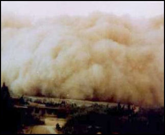
dust storm in China Desert Climate is generally dry and hot, with low humidity. Temperatures can drop quite low at night because heat that arrives during the day, with no clouds to hold it in, escapes into the atmosphere at night. In some deserts in Saudi Arabia temperature can drop below freezing as late as April. In the hottest deserts in the winter, temperatures can rise to the 90s F (30s C) in the day and drop to the 30s F (single digits C) at night.
The summer is so hot that shoes fall apart because the glue melts, thermometers don’t have high enough readings to record the high temperatures, and the hot sands can reach 180 degrees F. The air is so dry that pages fall out of books because the bindings fail. At night the temperature drops only to 85 degrees or 90 degrees F (30 degrees C) and people sleep on their roof to escape the heat.
Websites and Resources on Deserts: United States Geological Survey usgs.gov/gip/deserts ; Desert USA (good info on the world’s deserts); desertusa.com/life ; United Nations Global Desert Outlook unep.org/geo/gdoutlook ; Desert Biome article, University of California, Berkeley Desert Biome ; Blue Planet Biomes (about U.S. deserts) blueplanetbiomes.org ; Wikipedia article Wikipedia ;National Geographic online article National Geographic Oxfam Cool Planet oxfam.org.uk/coolplanet ; Sand Dunes article waynesword.palomar.edu ; United States Geological Survey usgs.gov/gip/deserts
Climate and Weather in Saudi Arabia
Arabia one of the world’s hottest and driest places. With the exception of a brief, cool, rainy period in the winter, hot, dry weather prevails the entire year. There can be great extremes of hot and cold. Daytime and nighttime temperature differences of 80 degrees F (45 degrees C) have been recorded. Temperature in some areas cooled somewhat by elevation and nearness to the sea.
Precipitation is generally scarce, and most of it originates in the Mediterranean. Very little rain comes in from the Persian Gulf, Red Sea or Sahara. Mountains along west coast block much of the moisture from the Mediterranean. Mountains in Yemen and Oman block much of the moisture carried in by the monsoons. As a result the rainfall amounts are considerably lower in central and eastern Saudi Arabia than in the western part of the kingdom.
In the desert regions rainfall can vary greatly from month to month and year to year. Some places go years without seeing any rain. Rain, when it does come, arrives in the form of deluge in fierce, short-lived storms. Riyadh, and the barren deserts in the south and east get between nothing and 5 inches (13 centimeters) of rain a year. Rain is mostly likely to fall in February, March and April in Riyadh; and December, January, February and March in eastern Saudi Arabia. The highest rainfall amounts occur on the western slopes of the coastal mountains. Some places here have average annual rainfalls is above 15 inches (50 centimeters) a year.
Saudi Arabia suffers water shortages and droughts. The coastal areas of the Red Sea and the Persian Gulf can be as oppressively humid and as they are oppressively hot. In other places the air is often hot and dry during the day and damp at night.
Winter in Saudi Arabia is warm in most of the country, with high temperatures in the 70s and 80s F (20s C), and cool in the mountains, where the temperatures may fall below freezing at night. Polar air masses that occasionally blow south from Russia can bring some truly cold weather. After the rains of a normal winter, the brown hills of Saudi Arabia can erupt with carpets of red poppies, anemones, blue cornflowers and lupines.
Summer in Saudi Arabia is very hot throughout the country and lasts from May to November. There is generally no rain. In most of Saudi Arabia the highs are in the 100s or 110s F (40s C). Some places are extremely hot, with temperatures often rising above 120 degrees F (50 degrees C).
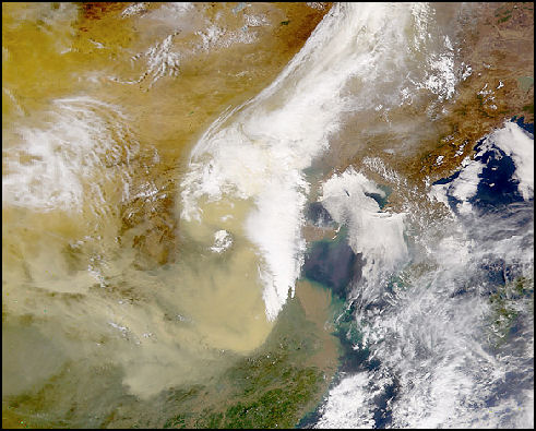
Satellite image of a Gobi dust storm
Climate, the Atmosphere, the Earth and Deserts
We live at the bottom of a gaseous envelope--the atmosphere--that is bound gravitationally to the planet Earth. The circulation of our atmosphere is a complex process because of the Earth's rotation and the tilt of its axis. The Earth's axis is inclined 23.5̊ from the ecliptic, the plane of the Earth's orbit around the Sun. Due to this inclination, vertical rays of the Sun strike 23.5̊ N. latitude, the Tropic of Cancer, at summer solstice in late June. At winter solstice, the vertical rays strike 23.5̊ S. Latitude, the Tropic of Capricorn. In the Northern Hemisphere, the summer solstice day has the most daylight hours, and the winter solstice has the fewest daylight hours each year. The tilt of the axis allows differential heating of the Earth's surface, which causes seasonal changes in the global circulation. [Sources: “Deserts: Geology and Resources” by A.S. Walker, United States Geological Survey]
On a planetary scale, the circulation of air between the hot Equator and the cold North and South Poles creates pressure belts that influence weather. Air warmed by the Sun rises at the Equator, cools as it moves toward the poles, descends as cold air over the poles, and warms again as it moves over the surface of the Earth toward the Equator. This simple pattern of atmospheric convection, however, is complicated by the rotation of the Earth, which introduces the Coriolis Effect. The Guardian
To appreciate the origin of this effect, consider the following. A stick placed vertically in the ground at the North Pole would simply turn around as the Earth rotates. A stick at the Equator would move in a large circle of almost 40,000 kilometers with the Earth as it rotates.
Coriolis Effect, Wind, Air Circulation and Deserts
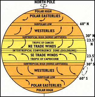
The Coriolis Effect illustrates Newton's first law of motion--a body in motion will maintain its speed and direction of motion unless acted on by some outside force. Thus, a wind travelling north from the equator will maintain the velocity acquired at the equator while the Earth under it is moving slower. This effect accounts for the generally east-west direction of winds, or streams of air, on the Earth's surface. Winds blow between areas of different atmospheric pressures.
The Coriolis Effect influences the circulation pattern of the Earth's atmosphere. In the zone between about 30̊ N. and 30̊ S., the surface air flows toward the Equator and the flow aloft is poleward. A low-pressure area of calm, light variable winds near the equator is known to mariners as the doldrums. [Sources: “Deserts: Geology and Resources” by A.S. Walker, United States Geological Survey]
The circulation pattern of the Earth's atmosphere. Most of the nonpolar deserts lie within the two trade winds belts. Around 30̊ N. and S., the poleward flowing air begins to descend toward the surface in subtropical high-pressure belts. The sinking air is relatively dry because its moisture has already been released near the Equator above the tropical rain forests. Near the center of this high-pressure zone of descending air, called the "Horse Latitudes," the winds at the surface are weak and variable. The name for this area is believed to have been given by colonial sailors, who, becalmed sometimes at these latitudes while crossing the oceans with horses as cargo, were forced to throw a few horses overboard to conserve water.
The surface air that flows from these subtropical high-pressure belts toward the Equator is deflected toward the west in both hemispheres by the Coriolis Effect. Because winds are named for the direction from which the wind is blowing, these winds are called the northeast trade winds in the Northern Hemisphere and the southeast trade winds in the Southern Hemisphere. The trade winds meet at the doldrums. Surface winds known as "westerlies" flow from the Horse Latitudes toward the poles. The "westerlies" meet "easterlies" from the polar highs at about 50-60̊ N. and S.
Desert Winds
Near the ground, wind direction is affected by friction and by changes in topography. Winds may be seasonal, sporadic, or daily. They range from gentle breezes to violent gusts at speeds greater than 300 kilometers/hour.
Low pressure in the Persian Gulf generates regular wind patterns in the Middle East, with the prevailing winds blowing from north to south. Saudi Arabia can get very windy and experience nasty sandstorms, particularly in the spring and summer. The “shamal” and “sharqi” winds blows from northwest through the Tigris and Euphrates Valley from March until September. These winds bring cool weather and can reach speeds of 60mph and kick up fierce sandstorms. In September, the humid “date wind” blows off the Persian Gulf and ripens the date crop.
The “Khamsin” is a hot, dusty, wind associated with North Africa that sometimes reaches Saudi Arabia. It blows up from the south during the summer. Sometimes beginning as early as April, it lasts for two or three days and is strong enough to kick up huge clouds of dust and sand and damage vegetation.
“Etesian” is an eastern Mediterranean summer that blows from the north towards the Sahara and from the Near East highlands towards the sea. It is also called a “Meltemi” . Sometimes sandstorms suddenly whip up, particular in khamsin season, shutting down flights, reducing visibility to near zero and sometimes killing people. These are often accompanied by thunderstorms or “sinoons” (hot sand-laden storms).

Desert Belt
Most of the world's deserts lie along the Tropic of Cancer and Tropic of Capricorn between 20 degrees and 35 degrees latitude on the western sides of continents. They are located in the path of the trade winds, which blow from the northeast in the northern hemisphere and from the southeast in the southern hemisphere, or the adjacent horse latitudes.
Beginning at the equator, rainy tropical hot air rises and is deflected to the north and south. As the hot equatorial air moves it sheds its moisture and cools. The cooled air subsides and warm up again between 15 degrees and 30 degrees latitude, where deserts are found.
Rising air causes rain. Subsiding air like that found in the desert belts is dry and doesn't set in motion in the chain of events necessary for rain. Consequently rain clouds don't form and deserts form. In the desert subsiding hot air sucks moisture out of the atmosphere. This air then loops back to the equator and plunging down as rain.
The weather pattern described above, sometimes called the sub-tropical high-pressure belt, parches the Sahara, the Middle East, Central Asia, northern Mexico, and the southern United States in the northern latitudes; and the Kalahari and Namib Deserts of Africa, the deserts of Peru, Chile, and Australia's barren outback in the southern latitudes.
Rain Shadows, Coastal and Middle Latitude Deserts
Moisture is generally carried in by winds from the nearest sea. Mountains often block these clouds as they move inland. As a result the rainfall amounts are considerably higher in windward sides of the mountains than on the leeward sides. This phenomena is sometimes called the rain shadow.
Coastal deserts tend to form in areas where cold ocean currents run along the coast. When winds blow from the cold ocean to the warm land, dry air is heated and little rain falls. To produce rain moist air needs to be cooled.
Middle latitude deserts are located at the interior of continents and are created by the rain shadow effect and the blocking from rain-bearing clouds by mountains.
Features of Desert Weather
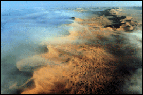
coastal fog in the Namib Desert The absence of clouds in the desert and an omnipresent daytime sun means no rain and no shade and high temperatures in the day. It also denies the land of a blanket that would normally trap heat at night. This means it can get quite cold at night. Temperatures variances of 25 degrees to 40 degrees are common. Variances as much as 60 degrees or 70 degrees occur.
At night the bare, dry earth quickly releases the heat its has absorbed during the day. In the dry air, with no insulating clouds to block it, the heat rises high into the atmosphere. Near the surface, the temperatures steadily drops during the night and reaches its lowest point before dawn.
Deserts can also have a temperature variance between the winter and summer. Some deserts in Central Asia have an average temperature in July of 90 degrees F and an average temperature in January of -17 degrees F.
Deserts have very low humidity. What little moisture there is evaporates very quickly. Many deserts produce enough heat to evaporate 20 times the amount of rainfall they receive.
Temperatures in some deserts climbs above 50 degrees C (122 degrees F), a heat so intense that rocks become too hot to touch, steel vehicles are transformed into ovens hot enough to melt paint on the walls, and pens are too hot to write with. The sunlight itself can be blinding.
In arid regions, sunlight, particularly ultraviolet-B light, is responsible for decomposition. In places where there is plenty of water bacteria usually does the job.
Rain and Flash Floods
Rain does fall occasionally in deserts, and desert storms are often violent. A record 44 millimeters of rain once fell within 3 hours in the Sahara. Large Saharan storms may deliver up to 1 millimeter per minute. Normally dry stream channels, called arroyos or wadis, can quickly fill after heavy rains, and flash floods make these channels dangerous. More people drown in deserts than die of thirst.
Rain can be quite destructive. "In this almost rainless land," adventurer and journalist Michael Asher. "a rare downpour could wreak more havoc than an army of raiders." A guide pointing to a ruined house told him,"We used to live here when I was young," "but then a great shower of rain came that lasted three days. It only rains here once every 40 years, but when it rains these mud-brick houses come crashing down like paper. There were even people trapped inside, by God! The government declared it was forbidden to live here after that."
Rain is often accompanied by hail. Sudden downpours produce flash floods that cause a lot damage and even kill people if they are in the wrong place at the wrong time. Flash floods can occur when there is no rain in the area: by distant downpours that fill stream beds or by sudden snow melts in the mountains
The downpours cut gullies and fill dry stream beds. Sometimes there is enough water to fill a shallow lake in a basin. Most are temporary lakes called playas with layers salt deposited when the water evaporates.
Mirages and Dust Devils
Mirages, which appear like silvery water, are caused by light from the sun reflecting off a layer of turbulent heated air near the desert surface. They are most common on hot days on a flat, heated surfaces. The "water" is simply a reflection of the sky. As one approached it disappears.
Small whirlwinds, called dust devils, are common in arid lands and are thought to be related to very intense local heating of the air that results in instabilities of the air mass. Dust devils may be as much as one kilometer high.
Desert Sandstorms and Dust Storms
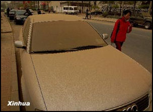
Storm sand left behind in Beijing
Deserts are windy places. Part of the reason for this is the great variances in temperature. When winds kick up the air is filled with fine dust and grit that collects in the nose, eyes and throat if there is no protection. During period of high winds or during a dust storm or sandstorm you should cover your nose and mouth with a handkerchief or other piece of cloth.
Eolian turbidity currents, the scientific name for dust storms occur because air over deserts is cooled significantly when rain passes through it. This cooler and denser air sinks toward the desert surface. When it reaches the ground, the air is deflected forward and sweeps up surface debris in its turbulence as a dust storm. [Sources: “Deserts: Geology and Resources” by A.S. Walker, United States Geological Survey]
Dust storms and sand storms are fierce desert storms that send sand, dust and grit hurling through the air at high velocities and make the sky and air opaque and amber-yellow or rusty brown in color. Sometimes they are accompanied by thunderstorms. The winds are sometimes powerful enough to blow people over and the dust and sand are thick enough to fuse eyelids shut and freeze anything with moving parts. Skin dries out so much that people put lip balm all over their face.
Most of the dust carried by dust storms is in the form of silt-size particles. Deposits of this windblown silt are known as loess. The thickest known deposit of loess, 335 meters, is on the Loess Plateau in China. In Europe and in the Americas, accumulations of loess are generally from 20 to 30 meters thick.
Crops, people, villages, and possibly even climates are affected by dust storms. Dust storms and sand storms can close airports and other facilities. They can cause eye and respiratory infections and transport dangerous bacteria and fungi to far away places. An increasing number of sandstorms around the world are linked with global change and are blamed for spreading deserts and making them bigger. Some dust storms are intercontinental, a few may circle the globe, and occasionally they may engulf entire planets. When the Mariner 9 spacecraft arrived at Mars in 1971, the entire planet was enshrouded in global dust.
Description of a Sandstorm
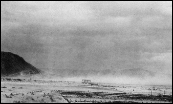
Mojave dust storm in 1919 Describing a desert sandstorm in Iraq, Arian Campo-Flores wrote in Newsweek, “The wind whipped into a frenzy and the air began to glow a seemingly radioactive red. Tents strained against their poles, and any loose objects fired away like a projectile. Minutes later the sky turned dark and we were fully enveloped in dust. Then thunder cracked the sky and it began to rain mud, as moisture in the air gathered particles on its way to earth.”
“The sand — much of it as fine as flour — is inescapable. It infiltrates every sealed container and every orifice...We ended up eating ham and rice suffused with sand...Simply waking 100 feet to an adjacent squad required using a Global Positioning System. Those attempting to defecate in the field had to contended with dust surging up their back sides — and toilet paper being yanked from heir hands in the howling wind.
“Sandstorms exact a physical and psychological toll. Your breathing becomes labored....Goggles and bandanas are de rigeur. Bombarded with fine particles, your body responds by emitting copious amounts of fluids. Your nose seeps brown snot. Your throat discharges dark phlegm. Your eyes — which quickly turn scarlet from irritation — shed tears continuously, releasing muddy rivulets on your face.”
Desert Coastal Fogs
Thick fogs, known as “camanchaca”, rolls in from the Pacific ocean and backs up against the coastal mountains nourishing cacti and small shrubs. On occasion the fog is so thick it looks as if a downpour is imminent, but rain clouds rarely materialize. Cool air holds less moisture than hot air and the air blowing in off coastal waters hold little moisture because it is cooled by ocean currents which are bringing up cold water from the south and from the depths of the ocean. When the coastal air reaches the land its relative humidity is lowered by subsidence, making the formation of rain clouds even more difficult. [Source: Rick Gore, National Geographic November 1979]
Every few years some coastal towns in Chile get a mist, but the drops were extremely small. Rain is so infrequent that many coastal towns in Chile have holes in the roof and people in one village still talk about a "flood" decades ago when it rained all day and floors became soaked. ┵
Fog farmers collect fog in huge polyurethane nets and use it for agriculture. It takes something like 20,000 dew drops to equal one drop of water. The water is collected and used for irrigation. Initially it was used to supply water for drought-resistant trees. Now it used to grow potatoes, tomatoes and vegetables.
Image Source: United States Geological Survey (USGS) usgs.gov/gip/deserts ; except China storm pictures, Xinhua
Text Sources: "Deserts Geology and Resources" by A.S. Walkers, USGS Online publication; Rick Gore, National Geographic, November 1979 [┵]; New York Times, Washington Post, Los Angeles Times, Daily Yomiuri, Times of London, National Geographic, The New Yorker, Time, Newsweek, Reuters, AP, Lonely Planet Guides, Compton’s Encyclopedia and various books and other publications.
Last updated March 2011
