WORST RECORDED EARTHQUAKES

Tokyo 1923 An earthquake in northern Japan in A.D. 869 is believed to have been the strongest earthquake to hit Japan in historical times. Based on evidence of a tsunami produced by the quake along the Pacific coast it was estimated to have had a magnitude of 9 on the Richter scale. About 1,000 people are thought to have been killed by a tsunami produced by the quake that dumped water three kilometers inland in the Sendai area.
Worst Recorded Earthquakes (number of dead): 1) Shaanxi, China, Jan. 24, 1556 (830,000); 2) Calcutta, India, Oct. 11, 1737 (300,000); 3) Tangshan, China, July 28, 1976 (242,000); 4) Antioch, Syria, May 20, 526 (240,000); 5) December 26, 2004, Sumatra in 2004 (225,000); 6) Yokohama , Japan, Sept. 1, 1923 (200,000); 7) Nan-Shan, China, May 22, 1927 (200,000); 8) Hokkaido Japan , Dec. 30, 1730 (137,000); 9) Chihli, China, Sept. 27, 1290 (100,000); 10) Gansu, China, Dec. 16, 1920 (100,000); 11) Sichuan China, May 12, 2008 (90,0000); 12) (100,000) Messina, Italy, Dec. 28, 1908 (83,000); 13) Shemaka, Caucasia, Nov. 1667 (80,000); 14) Gansu, China, Dec. 26, 1932 (70,000); 15) Northern Peru, May 31, 1970 (66,794); 16) Cilicia, Asia Minor, 1268 (60,000);
17) Catania, Italy, Jan. 11, 1693 (60,000); 18) Lisbon, Portugal, Nov. 1, 1755 (60,000); 19) Armenia, Dec. 7, 1988 (55,000); 20) Quetta, India, May 31, 1935; 21) Corinth, Greece, 856 (45,000); 22) Quito, Ecuador, Feb. 4, 1797 (41,000); 23) Northwest Iran, June 21, 1990 (40,000+); 24) N. Persia, June 7, 1755 (40,000); 25) Peru, Ecuador, Aug 13-15, 1868 (40,000); 26) Kamakura, Japan , May 20, 1293 (30,000); 27) Lisbon, Portugal, Jan 26, 1531 (30,000); 28) Calabria, Italy, Feb. 4, 1783 (30,000); 29) Echigo, Japan , Dec. 28. 1828 (30,000); 30) Erzincan, Turkey, Dec. 26, 1939 (30,000); 31) Avezzano, Italy, Jan. 13, 1913 (29,980); 32) Chilean, Chile, Jan. 24, 1939 (28,000);
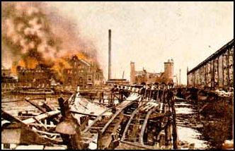
An earthquake in Tokyo in 1855 left more than 10,000 people dead. An earthquake in 1927 raised the land along two faults by more than two meters. The tectonic makeup of Tokyo and surrounding areas is complicated, with two ocean plates subducting below a land plate on which the Japanese archipelago is located. There have been many earthquakes in this area, as both plate-boundary quakes, which are caused by friction between the plates, and inland quakes, which are caused by faults in the plates, can occur.
See Separate Articles GREAT TOKYO EARTHQUAKE OF 1923 factsanddetails.com ; KOBE EARTHQUAKE OF 1995 factsanddetails.com ; MAJOR EARTHQUAKES IN JAPAN IN THE 2000s factsanddetails.com ; LARGE TSUNAMIS AND EARTHQUAKES IN JAPAN factsanddetails.com
Study Reveals Five Huge Ancient Kanto Quakes
In September 2012, Jiji ress reported: “At least five huge earthquakes similar to the magnitude-7.9 Great Kanto Earthquake in 1923 hit the region between 4,000 and 2,000 years ago, researchers have revealed.In the study, researchers from the University of Tsukuba, the University of Tokyo, Tohoku University and other institutions analyzed sediments brought by tsunami to the southeast coast of the Miura Peninsula in Kanagawa Prefecture. They found evidence that massive earthquakes with a magnitude of about 8 on the Richter scale occurred in the Kanto region at least five times--2,000 years ago, 3,000 years ago, 3,300 years ago, 3,700 years ago and 4,000 years ago. [Source: Jiji Press, September 25, 2012]
It is already known that earthquakes as powerful as the 1923 quake that devastated Tokyo and surrounding areas periodically occur due to the subduction of the Philippine Sea Plate under the North American Plate along the Sagami Trough, which stretches beneath the Pacific Ocean off the Kanto region.In 2004, a government study team estimated after analyzing existing data that the 1923-type quakes have a recurrence interval of about 200 to 400 years.
Massive 794 Earthquake Thought to be a Nankai Earthquake
A massive earthquake believed to be a Nankai earthquake occurred in 794 when the capital was transferred from Heijokyo in Nara Prefecture to Heiankyo in Kyoto Prefecture, according to historical documents, Katsunori Imazu, an associate professor at Okayama University told the Yomiuri Shimbun. Nankai earthquakes are believed to occur in 100-year cycles, but historical documents from a 200-year period before and after the earthquake have not been found. Imazu said the 794 earthquake occurred in the middle of this blank period. [Source: Yomiuri Shimbun, April 20, 2012]
“Imazu found a statement that suggests the occurrence of a massive earthquake in a historical document called Nihon Kiryaku, which was compiled in the Heian period (794-1192) and summarizes the contents of Nihon Koki, an officially commissioned Japanese history text. The statement dated July 10, 784, says: "The earthquake hit the imperial court as well as the government quarters and houses in Keiki [modern-day Kyoto and its surrounding areas]. People died due to the earthquake." He also found statements related to the earthquake that said the Nankaido, an ancient road along the coast of Shikoku, was shut down and a new road was built two years later. Imazu concluded the 794 earthquake was a Nankai earthquake because the epicentral area was estimated in the Pacific, and said the Nankaido was closed due to a tsunami following the quake.
A trough is an underwater depression, or trench, lies at the intersection of a plate on the land side and a plate on the sea side.. The Nankai Trough originates from Suruga Bay, west of the Izu Peninsula. It extends to the seabed off the southern part of the Japanese archipelago, which is about four kilometers deep off the Shikoku and Kyushu regions. Along the Nankai Trough, the Philippine Sea Plate is moving beneath a land-side plate at a rate of several centimeters per year, dragging with it part of the latter at the point where they meet. When the land-side plate has been pulled to a certain extent, it is bound to spring back with tremendous force. This is how a massive earthquake occurs where plates meet. [Source: Yomiuri Shimbun, April 17, 2012]
Jogan Earthquake and Tsunami in A.D. 869
There was a great tsunami in A.D. 869. Generated by a quake known as Jogan, it struck the Sendai area and produced tsunami waves that reached almost two kilometers inland in an area just north of the present-day Fukushima nuclear power plant. According to Japan's historical document, "Nihon Sandai Jitsuroku" ("The True History of Three Reigns of Japan"), compiled during the early Heian Period (794-1192), the Jogan Tsunami flooded inland areas more than three kilometers from shore and killed more than 1,000 people.
The 869 Jogan earthquake (also known as the Sanriku earthquake or Jo-gan jishin) and associated tsunami struck the area around Sendai in the northern part of Honshu on July 9, 869 (26th day of 5th month, 11th year of Jo-gan). The earthquake had an estimated magnitude of 8.6 on the surface wave magnitude scale. However, it is likely that the moment magnitude rating may have been similar to the 2011 To-hoku earthquake and tsunami at around 9.0. [Source: Wikipedia +]
According to the Active Fault and Earthquake Research Center the quake that caused the Jogan Tsunami made the fault slip more than seven meters. According to a report submitted by the national institute to the government in the spring of 2010, the Jogan Earthquake occurred off Miyagi and Fukushima prefectures and is estimated to have had a magnitude of about 8.3 or 8.4. The Jogan Earthquake tsunami penetrated more than four kilometers inland in the Sendai plain in Miyagi Prefecture, and about 1.5 kilometers inland in an area where Minami-Soma, Fukushima Prefecture, is currently located, the report said. According to a study conducted by Tohoku University, two tsunamis equivalent to the size of the Jogan Earthquake tsunami have hit the Sendai plain in the past 3,000 years. [Source: Yomiuri Shimbun, June 12, 2011 ^^]
A passage in the “Nihon Sandai Jitsuroku” read: “The lands of Mutsunokuni were severely jolted. The sea covered dozens, hundreds of blocks of land. About 1,000 people drowned...The sea soon rushed into the villages and towns, overwhelming a few hundred miles of land along the coast. There was scarcely any time for escape, though there were boats and the high ground just before them. In this way about 1,000 people were killed.” Mutsunokuni is the name of the region that covered most of the present-day prefectures in the Tohoku region. ^^
According to the "Nihon Sandai Jitsuroku:" On 26th day of 5th month (9 July 869 AD) a large earthquake occurred in Mutsu province with some strange light in the sky. People shouted and cried, lay down and could not stand up. Some were killed by the collapsed houses, others by the landslides. Cattle got surprised, madly rushed around and injured the others. Enormous buildings, warehouses, gates and walls were destroyed. Then the sea began roaring like a big thunderstorm. The sea surface suddenly rose up and the huge waves attacked the land. They raged like nightmares, and immediately reached the city center. The waves spread thousands of yards from the beach, and we could not see how large the devastated area was. The fields and roads completely sank into the sea. About one thousand people drowned in the waves, because they failed to escape either offshore or uphill from the waves. The properties and crop seedlings were almost completely washed away. +
See Separate Article LARGE TSUNAMIS AND EARTHQUAKES IN JAPAN factsanddetails.com
Ansei Great Earthquakes
The Ansei Great Earthquakes (Ansei no Dai Jishin) were a series of three major earthquakes that struck Japan during the Ansei era (1854–1860). The 1855 earthquake was blamed on a giant catfish (Namazu) thrashing about. Ukiyo-e prints depicting namazu became very popular around this time. Other notable quakes to strike in the Ansei period include one in the Iga area, one which registered 7.4 on the Richter scale and struck Kyushu and Shikoku . [Source: Wikipedia +]
The Ansei-To-kai Quake (Ansei To-kai Jishin) was an 8.4 magnitude earthquake which struck on December 23, 1854. The epicenter ranged from Suruga Bay to the deep ocean, and struck primarily in the To-kai region, but destroyed houses as far away as in Edo. The accompanying tsunami caused damage along the entire coast from the Bo-so- Peninsula in modern-day Chiba prefecture to Tosa province (modern-day Ko-chi prefecture) The Ansei-Nankai Quake (Ansei Nankai Jishin) was an 8.4 magnitude earthquake which struck on December 24, 1854. Over 10,000 people from the To-kai region down to Kyushu were killed. +
The Ansei Edo Quake (Ansei Edo Jishin) was a 6.9 magnitude earthquake which struck Edo (modern-day Tokyo) on November 11, 1855. One hundred and twenty earthquakes and tremors in total were felt in Edo in 1854-55. The great earthquake struck after 10 o'clock in the evening; roughly 30 aftershocks continued until dawn. The epicenter was near the mouth of the Arakawa River. Records from the time indicate 6,641 deaths inside the city, and 2,759 injuries; much of the city was destroyed by fire, leading many people to stay in rural inns. Aftershocks continued for twenty days. This quake was a particularly destructive deep thrust quake caused by a giant slab of rock stuck between the Philippine Sea Plate and the Pacific Plate. +
Impact of Earthquakes and the Disasters in the Ansei Era (1854-1860)
Masayuki Yamauchi is a professor at the University of Tokyo's Graduate School of Arts and Science, wrote in the Yomiuri Shimbun, “During the Ansei era (1854-1860), a host of devastating earthquakes and epidemics occurred, compounded by domestic political crises, forcing the political leaders of the day to rise to challenges. In 1854, the first year of the Ansei era, when the Tokugawa shogunate bowed to Commodore Matthew Perry in opening Japan to the United States, the Great Tokai Earthquake and the Great Nankai Earthquake, both magnitude-8 tremors, and the magnitude-7.4 Great Hoyo Earthquake occurred, causing terrible tsunami damage to Pacific coastal areas. In October 1855, the magnitude-6.9 Ansei Edo Great Earthquake battered the capital. One of its most prominent victims was Fujita Toko, a senior Mito domain official, who was crushed to death. Yet, this temblor was smaller than the magnitude-7.4 quake that rocked the Iga Ueno area — now in Mie Prefecture — in June 1854.” [Source: Masayuki Yamauchi, Yomiuri Shimbun. May 8, 2011]
“In 1856, a typhoon swept through the Izu Peninsula and the northern parts of Edo, now Tokyo, causing widespread floods along the Tonegawa and Arakawa rivers, killing about 100,000 people. An influenza epidemic in 1857 was followed by cholera epidemic that claimed the lives of 100,000 to 300,000 people. The cholera was brought to Japan by a U.S. naval fleet. In 1859, a large number of people died from a measles outbreak, an event known as the Great Ansei Mashin (measles).”
“In the face of these calamities, the Ansei "prime ministers" of the shogunate, Abe Masahiro and Hotta Masayoshi, did not hesitate to pick up the gauntlet with extraordinary resolution and courage. Hotta assumed the post of chief of the Council of Elders (roju) — ranking immediately below the shogun — only a week after the 1855 Edo earthquake and started tackling a series of internal and external difficulties.”
“Even before taking up his new post, Hotta ordered shelters erected for quake victims two days after the earthquake, had emergency kitchens provide food and ordered emergency rice distribution. By today's standards, he acted extremely swiftly...The Tokugawa shogunate, however, continued to weaken as it was forced to carry out emergency fiscal spending to finance disaster reconstruction. If the Ansei streak of calamities had not occurred, the shogunate might not have helplessly yielded to the alliance of the rebellious Satsuma and Choshu domains, both of which suffered almost no damage from the natural catastrophes. By extension, measures taken against disasters and reconstruction efforts elsewhere would have imposed political challenges so serious they could have upended any regime.
Famous Earthquakes in Japan in the 19th and 20th Centuries
On October 28, 1891, a devastating quake hit the former provinces of Mino and Owari. Records show that there tragedy caused 7,273 deaths and 17,175 casualties. Based on the destruction, the Mino-Owari Earthquake is estimated that the Richter Scale hit a magnitude of 8.0. [Source: Time.com, Japan's History of Massive Earthquakes]
The 1946 Nankaido Earthquake. On December 20, an earthquake occurred in the submarine region of the Nakai Trough, a zone where large earthquakes have been reported since the 7th century. The tremors were felt from the northern parts of Honshu to Kyushu, Japan's southern island. The devastation destroyed approximately 36,000 homes and left about 1,360 dead, 2,600 injured and another 100 people missing. In addition, the quake triggered a tsunami that destroyed about 2,100 homes.
The 1948 Fukui Earthquake. On June 28th a 7.1 magnitude earthquake struck the Chubu region of Honshu at 5:13pm. The intense tremors hit the city of Fukui the hardest, causing the collapse of the Nakazuno Bridge and liquefaction, by which the violent shakes and vibrations of the quake cause loosely packed soil to behave like liquid, making it unable to support building foundations. An estimated 67,000 homes were destroyed and 3,894 civilians lost their lives in the tragedy.
The 1964 Niigata Earthquake. A 7.6 magnitude quake ferociously shook the northwest coast of Honshu, Japan's largest island, on June 16th at 1:01pm, causing liquefaction and claiming the lives of 26.
The 1978 Miyagi Earthquake. This June 12th quake hit at 5:14 PM, rocking the northeastern part of Honshu with a 7.7 magnitude, causing massive landslides that destroyed over 1,100 homes houses and killed 28 people. This earthquake was so catastrophic that in 1981, the Building Standard Law was revised to require stricter seismic design codes.
Worst Earthquakes in Japan in the 20th Century
1923 Tokyo Earthquake Worst earthquakes in Japan in the 20th century (date; magnitude; dead; destroyed buildings): 1) Tokyo Earthquake (September 1, 1923; 7.9; 142,807; 576,262) 2) Kobe Earthquake (January 17, 1995; 7.2; 6,435; 512,880); 3) Fukai Earthquake (June 28, 1948; 7.1; 3,848; 39,111); 4)Sanriku Offshore Earthquake (March 3, 1933; 8.1; 3,008; 7,479); 5) Kita-Tango Earthquake (March 7, 1927; 7.3; 2,925; 16,295); 6) Mikawa Earthquake (January 13, 1945; 6.8; 2,306; 12,142; 7) Nankai Earthquake (December 21, 1946; 8.0; 1,432; 15,640); 8) Tottori Earthquake (September 19, 1943; 7.2; 1,083; 7,736); 9) Tonankai Earthquake (December 7, 1944; 7.9; 998; 29, 189). 10) Kita-Tajima Earthquake (May 23, 1925; 6.8; 428; 3,475)
Most deadly earthquakes since 1900 (magnitude on the Richter scale): 1) China in 1976, 255,000 dead (7.5);2) Sumatra in 2004, 225,000 dead (9.3); 3) China in 1927, 200,000 dead (7.9); 4) China in 1920, 200,000 dead (8.6); 5) Japan in 1923 , 143,000dead (7.9).
Most powerful earthquakes since 1900 (magnitude on the Richter scale): 1) Chile on May 22, 1960 (9.5); 2) off Sumatra, Indonesia on December 26, 2004 (9.3); 3) Prince William Sound in Alaska on March 28, 1964 (9.2); 4) Andreanof Islands, Alaska on March 9, 1957 (9.1); 5) Kamchatka Peninsula in eastern Russia on November 4, 1952 (9.0); 6) off the coast of Ecuador on January 31, 1906 (8.8); 7) Rat Islands, Alaska on February 4 1965 (8.7); 7) off Nias Island, Indonesia on March 28, 2005 (8.7); 9) Tibet on August 15, 1950 (8.6); 10) Kamchatka Peninsula in eastern Russia on February 3, 1923 (8.5); 10) Banda Sea, Indonesia on February 1st 1918 (8.5); 10) off Etorofu Island, northern territories, Japan (8.5.) [Source: U.S. Geological Survey]
Image Sources: J.B. Macelwane Archives, St. Louis University, USGS
Text Sources: New York Times, Washington Post, Los Angeles Times, Daily Yomiuri, Times of London, Japan National Tourist Organization (JNTO), National Geographic, The New Yorker, Time, Newsweek, Reuters, AP, Lonely Planet Guides, Compton’s Encyclopedia and various books and other publications.
Last updated January 2014