OGASAWARA ISLANDS

THE OGASAWARA ISLANDS (1000 kilometers south of Tokyo) are a group of remote volcanic islands belonging to Japan that lie in the middle of the Pacific about halfway between Japan and Guam. Technically part of Tokyo, they include Chichijima, Haha-jima and Ani-jima and are known as the Bonin Islands in the West. They have some guest houses and mainly attract scuba divers and birdwatchers
The subtropical Ogasawara Islands have been dubbed the Galapagos Islands of the East, because the contain a large number of flora and fauna found nowhere else in the world. Created by undersea volcanos, they have sheer cliffs covered by layers of oval-shaped pillow lava and have never been connected to any mainland bodies. Until the arrival of man all the flaura and fauna on the islands evolved from organism carried by the wind or sea.
In December 2006, Tsunemi Kubodera, a scientist at the National Science Museum, caught a giant squid at dept of 650 meters about 27 kilometers off the northeast coast of Ototojima island in the Ogasawara Islands. The squid was not fully grown. It measured 3.5 meters despite have its two longest tentacles severed. It is is estimated that of the tentacles were intact the squid would have measures seven meters in length.
Ogasawara Islands: UNESCO World Heritage Site
The Ogasawara Islands were designated a UNESCO World Heritage Site in 2011. According to UNESCO: “The property numbers more than 30 islands clustered in three groups and covers surface area of 7,939 hectares. The islands offer a variety of landscapes and are home to a wealth of fauna, including the Bonin Flying Fox, a critically endangered bat, and 195 endangered bird species. Four-hundred and forty-one native plant taxa have been documented on the islands whose waters support numerous species of fish, cetaceans and corals. Ogasawara Islands' ecosystems reflect a range of evolutionary processes illustrated through its assemblage of plant species from both southeast and northwest Asia, alongside many endemic species. [Source: UNESCO]

“The Ogasawara Islands are located in the North-Western Pacific Ocean roughly 1,000 kilometers south of the main Japanese Archipelago. The serial property is comprised of five components within an extension of about 400 kilometers from north to south and includes more than 30 islands, clustered within three island groups of the Ogasawara Archipelago: Mukojima, Chichijima and Hahajima, plus an additional three individual islands: Kita-iwoto and Minami-iwoto of the Kazan group and the isolated Nishinoshima Island. These islands rest along the Izu-Ogasawara Arc Trench System. The property totals 7,939 ha comprising a terrestrial area of 6,358 ha and a marine area of 1,581 ha. Today only two of the islands within the property are inhabited, Chichijima and Hahajima.
“It is the combination of both the concentration of endemism and extent of adaptive radiation evident in the Ogasawara Islands which sets the property apart from other places illustrating evolutionary processes. When taking into account their small area, the Ogasawara Islands show exceptionally high levels of endemism in land snails and vascular plants.”
Ogasawara Islands Ecosystem
According to UNESCO: The landscape is dominated by subtropical forest types and sclerophyllous shrublands surrounded by steep cliffs. There are more than 440 species of native vascular plants with exceptionally concentrated rates of endemism as high as 70% in woody plants. The islands are the habitat for more than 100 recorded native land snail species, over 90% of which are endemic to the islands. [Source: UNESCO]
“The islands serve as an outstanding example of the ongoing evolutionary processes in oceanic island ecosystems, as evidenced by the high levels of endemism; speciation through adaptive radiation; evolution of marine species into terrestrial species; and their importance for the scientific study of such processes. The property's ecosystems reflect a range of evolutionary processes illustrated through its rich assemblage of plant species from both a Southeast Asian and a Northeast Asian origin. There is also a very high percentage of endemic species in selected taxonomic groups, resulting from these evolutionary processes. Within the flora it is an important centre for active, ongoing speciation.
“The Ogasawara Islands provide valuable evidence of evolutionary processes through their significant on-going ecological processes of adaptive radiation in the evolution of the land snail fauna as well as in their endemic plant species. The examples of fine-scale adaptive radiation between and sometimes within the different islands of the archipelago are central to the study and understanding of speciation and ecological diversification. This is further enhanced by the relatively low extinction rates in taxa such as the land snails.
Visiting the Ogasawara Islands

Tetsu Joko wrote in the Yomiuri Shimbun, “Approaching Chichijima island one sees a gigantic rock wall rising into the sky out of the cobalt blue ocean. A large, reddish-brown, heart-shaped feature that looks like it has been engraved in the wall is known as "Heart Rock" among residents of the Ogasawara Islands, of which Chichijima is a part. The rock surrounding Heart Rock is mostly a type of andesite called "boninite," a fine-grained rock that was created by underwater volcanoes about 48 million years ago and then rose to the surface of the sea with crustal movement. Such a massive amount of boninite in the ground is quite rare.
Much of the islands are composed of boninite s produced when magma cools near the Earth’s surface. Of the 447 plant species found on the island chain, 161, or 36 percent, are found nowhere else. The islands are also home to an unusually high number of land snail species. In the forest of Chichijima island, needle-thin burgundy plants shoot up from the mossy ground. There are suzufuri hongoso [Sciaphila okabeana Tuyama],an indigenous species only about four centimeters tall, and adorned with flowers and fruits just three millimeters wide.The recent UNESCO designation of the islands is expected to bring more tourists, which could also mean a threat of destruction of the natural environment.
The Ogasawara Islands are comprised of 30 large and small islands, which are divided into four groupings: the Chichijima Islands, the Mukojima Island, the Hahajima Island and the Ninamitorish Islands. Only Chichijima and Hajima — with population of just over 2,000 — are open to tourists, Chichijima can be reached a once-a-week ferry from Takeshiba pier in Tokyo. The ferry lands at Futami Port to Chichijima and takes 25 to 30 hours and cost between $200 and $550 one way. Plans to build an airport and introduce high speed boats have been shelved for environmental and cost reasons.
Minamijima is an uninhabited island located about 1.5 kilometers from Chichijima. There already too many tourists have trampled plants and exposed the island’s red soil. Japan’s Environment Ministry and the Tokyo metropolitan government have teamed up to protect the environment on the island by limiting walking routes as well as the number of tourists. The efforts have gradually paid off as the plants are coming back.
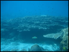
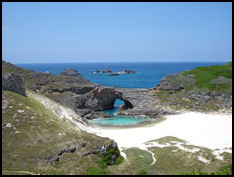
Hahajima is famous for birds. Minamjima Island boasts a rare underwater limestone sinkhole and beautiful white sand beaches and dunes There is good snorkeling at Anijima island underwater park A number of World War II wrecks lie on the ocean floor. .
Websites: Government National Park Site National Parks of Japan ;Wikipedia Wikipedia Bonin Islands; Dive Japan Dive Japan Map: Go Tokyo PDF gotokyo.org ; Getting There: The Ogasawara Islands are only accessible by ferry. The airport on Iwo Jima is not used by commercial aircraft. Lonely Planet Lonely Planet
Chichi Jima

Chichi Jima (one the Ogasawara Islands) is home to a handful of Japanese with European features. Descendants of whalers and adventurers who came to the island in the 19th century and married local Polynesian and Japanese women, they have names like Washington, Savory and Gonzalez and speak a language that mixes Japanese, English, Polynesian and Melanesian words.
Chichi became an important whaling station in the early 19th century after good supplies of freshwater were discovered there. Among those that stopped there were Commodore Matthew Perry and the writer Jack London. In 1944, former U.S. President George Bush, then a 20-year-old pilot, was shot down offshore and rescued by a submarine. During World War II, there were reports of cannibalism taking place there.
Chichijima is home to Japan’s only aquarium dedicated to turtles, particularly green turtles, and most of the hotels in the Ogasawara Islands. Activities on the island include swimming with dolphins and whale watching and turtle watching. The number of green turtles coming ashore to lay their eggs is increasing at a rate faster than anywhere else in the world. Sperm whales are often seen at a site about one hour from Chichijima. In the late autumn mothers are spotted with their calves.
Humpback whales breed in waters off the island from December to May, peaking in February and March. According to Oasawara Whale Watching Association about 20 whales a day can be seen from the Chichijima island observation tower if the conditions are good. The waters off the island are 200 meters of shallower with gentle waves, providing good breeding conditions.
Website: John LaPlant Tripod.com ; Getting There: Lonely Planet Lonely Planet ; Ogasawara whale watching Ogasawara whale watching
Iwo Jima

The beach where
American forces landed Iwo Jima (170 miles south Ogasawara, 1,250 kilometers south of Tokyo, halfway between the main islands of Japan and Guam) is where the famous World War II battle took place. Part of a group of volcanic islands called the Bonins, it is still off limits to travelers because of high number of unexploded shells on the island.
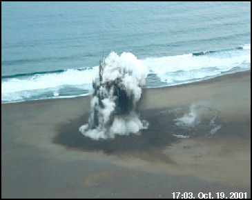
Iwo Jima is also very active volcanically. Some geologists speculate that the volcanos on Iwo Jima are ready to blow any time and the island my be the next Mt. St. Helens or Pinitabu. Iwo Jima means “Sulfur Island.” The island rose 46 centimeters between June 2006 and January 2007, growing 12 centimeters in a one month period in November and December 2006. This was more than it rose before it erupted in September 2001. Evidence of a steam explosion was seen late in 2007.
Iwo Jima is five miles long and two and half miles wide and covers 22.4 square kilometers, with 550-foot-high Mount Suribachi being the highest point on the island. Many of the original inhabitants were New Englanders who got dropped here by whaling vessels. A man called Uncle Charley Washington, who was 87 in 1968, for example, was the son of a black cabin boy who jumped ship in 1843.
Before World War II there were 202 inhalants with American ancestry known as "Yankees" and about 6,000 Japanese colonists. Some of the Yankees fought for the Japanese army but most were evacuated to the Japanese mainland. After the war the United States controlled the island the let descendants of the original island — 135 of them — return. In 1968 the Bonins and Iwo Jima were given to Japan, which to control of the islands so it can claim the fishing rights for the waters around them. [Source: Paul Sampson, National Geographic, July 1968]
Iwo Jima is now a Japanese military base as it was at the beginning of World War II. Iwo Jima can be visited only with military permission and usually only on military transport, usually a C-130 Hercules from Okinawa. U.S. Marines make periodic visits there to boost morale.
Visitor can visit the cave of the Japanese commander. It sits I 30 feet below the surface of the land and is still littered with possessions of Japanese soldiers who died there in the 1944 battle.
See World War II Website: Wikipedia Wikipedia
Conservation and Protection at the Ogasawara Islands

beach euption on Iwo JimaAccording to UNESCO: “The boundaries of the serial property cover the key values of the property and are well designed. The zonation and the legal protection provide an appropriate framework, while the boundaries of Ogasawara National Park serve as a functional overall buffer zone. Marine protected areas are partly included, contributing to more effective management of the terrestrial-marine interface and thus integrity. Integrity issues are mostly related to external threats, most importantly invasive alien species. The effects of invasive alien species and historic logging have already altered many of the archipelago's habitats. Future invasions have the potential to compromise the very values the Ogasawara Islands have been recognized for and therefore need careful and continuous attention. Possible future air access, as well as increased visitation and corresponding development potentially have strong and even irreversible effects in a fragile island environment. Control of access to the islands and of alien invasive species, two in part overlapping issues, is of critical importance for the conservation of the archipelago. [Source: UNESCO]
“The majority of the property is state-owned and under the authority of various agencies. Some land is owned by Ogasawara Village with some other areas privately owned. The property contains five legally designated categories of protected area managed by three national Government agencies and is surrounded by the much larger Ogasawara National Park serving as a functional buffer zone. The property is protected through seven pieces of national legislation which overlap in jurisdiction and objectives specifying the mandate of the Ministry of the Environment, the Forestry Agency and the Cultural Agency. Any jurisdictional conflicts are resolved through an interagency Regional Liaison Committee structure.
“The 2010 multi-agency Ogasawara Islands Management Plan and companion Ogasawara Islands Ecosystem Conservation Action Plan cover a wide area of 129,360 ha and include controls beyond the property such as ship navigation routes. The plans deal with critical issues such as access to the islands and control of alien invasive species. Management activities are detailed for the different island groups within the property with clear coordination mechanisms and monitoring plans prescribed. The plan is based on scientific knowledge and includes timetabled and prioritized actions.”
Image Sources: 1) 3). 4) 5) Wikipedia 2) Ogasawara National Park 6) 7) Tokyo University Volcano Research
Text Sources: JNTO (Japan National Tourist Organization), Japan.org, Japan News, Japan Times, Yomiuri Shimbun, Japan Ministry of the Environment, UNESCO, Japan Guide website, Lonely Planet guides, New York Times, Washington Post, Los Angeles Times, National Geographic, The New Yorker, Bloomberg, Reuters, Associated Press, AFP, Compton's Encyclopedia and various books and other publications.
Updated in July 2020
