KUMAMOTO

Amakusa Island church
Kumamoto (1½ hours from Fukuoka) is often called the city of woods because of its abundance of green groves. Kyushu's third largest city, it is home to 565,000 people and has a lively nightlife scene, a good tram system and is said to have the tastiest horsemeat in Kyushu.
Situated about five kilometers inland from the west coast of Kyushu on an extensive plain near the Shira River, Kumamoto was an important castle town in the 17th century. Today is serves as market center for the surrounding agricultural region. The city was founded in the 16th century and grew around the striking castle built and was a regional stronghold during the samurai era. Pilgrims and tourists visit Kumamoto's Buddhist temple and Shinto shrines. Industries in the city include food processing, textiles, and chemicals. Kumamoto has two universities and is home to about 740,000 people The Kumamoto area hosts Japan’s largest Country and Western music festival each October called "Country Gold," which sometimes attracts famous performers from the U.S.
Worth checking out in Kumamoto City are the Buddhist Pagoda on Hanaokayama Hill, where Prime Minister Nehru of India gave some of Buddha's ashes to the Emperor of Japan; Hosokawa Gyobutei, a villa with a collection of kimonos and everyday items and a white sand garden; the house of the writer Natsume Soseki; and the Kiizumi Yakumo Museum, the former home of Lafcadio Hearn. There is also an art museum, crafts museum, and nature park.
Contemporary Art Museum, Kumamoto (central Kumamoto) is one of the few contemporary art museums in Kyushu. Opened in 2002 and known by its abbreviation CAMK, its goal is to bring art closer to people’s lives, and to bring the community closer through art. Today, it is actively engaged in providing events for the community, and functions as a community center of sorts. Work by James Turrell are permanently installed amongst the unique bookshelves designed by Marina Abramovic. Address: 2-3 Kamitori-cho, Chuo-ku, Kumamoto-shi, Kumamoto 860-0845, Tel: +81-96-278-7500
Kumamoto Prefecture covers 7,409 square kilometers (2,860 square miles), is home to about 1.8 million people and has a population density of 241 people per square kilometer. Kumamoto is the capital and largest city, with about 740,000 people. It has nine districts and 45 municipalities. Kumamoto was hit hard by a 7.0-magnitude earthquake in 2016 that killed more than 50 people, splintered roads, triggered landslides and badly damaged many buildings including Kumamoto castle
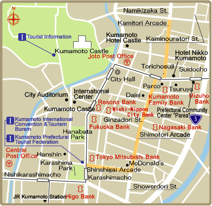
Tourist Office at the main train station has maps and pamphlets and an English-speaking staff that can offer advise on Kumamoto city and prefecture. Kumamoto Tram Map: Urban Rail Website: urbanrail.net Websites : Kumamoto Prefecture Tourism kumamoto.guide Kumamoto City Guide kumamoto-guide.jp Map: Explore Kumamoto explore-kumamoto.com
Ryokan and Minshuku Japanese Guest Houses Japanese Guest Houses Budget Accommodation: Japan Youth Hostels Japan Youth Hostels Check Lonely Planet books Getting There: Kumamoto is accessible by air and by bus and by train from Tokyo (10 hours) and Osaka (6 hours) and other Japanese cities. The shinkansen ends in Fukuoka-Hakata. The fastest train from there is the limited express. Lonely Planet Lonely Planet
Kunamoto Castle

Kumamoto Castle Kunamoto Castle is regarded as the best of Japan's reconstructed castles. Designated as an Important Cultural Property, it contains a dozen turrets and towering stone walls and stairs that make the castle grounds into a three dimensional maze. It is a delightful place to stroll around especially in the cherry blossom season when white and pink blossoms blend with fresh green from giant elms and camphor trees. The museum has an interesting collection of weapons, maps and palanquins.
Kumamoto Castle was originally built by the feudal lord Kato Kiyomasa (1562-1611) and at its height had 130 walls, 49 turrets, 18 turret gates, 29 castle gates and 5-kilometers of outer walls. The original castle was destroyed by fire in 1877 during the Satsuma Rebellion and rebuilt in 1960. Many of the stone walls are original. From the top there are wonderful views. Near the base of the castle is the beginning of the Shinmachi shopping and nightlife area.
Kumamoto Castle was built in 1607 and attracts about 1.7 million tourists a year. It is home to 13 important cultural properties designated by the central government, including the castle’s 11 scaffolds and a gate. Some stairways in the castle were built to different lengths in what was originally intended to make it difficult for enemy samurai to walk when they entered the premises. The keep, rebuilt in 1960 in concrete, is regarded as the symbol of the castle. It has two parts — a larger keep and a smaller one
Kumamoto Castle was badly damaged by the 2016 earthquake. Of those, two scaffolds completely collapsed and the roof and walls of a scaffold gate have also been damaged. In some places its massive walls crumbled. About 30 percent of the 79,000 sq.-meter wall is damaged, and a further 10 percent has completely collapsed. By some estimates it will take 10 years to repair the castle and 20 years to fix the walls. For a while visitors could only view the castle in limited locations, including Kato Shrine, where they can get closest to the collapsed tenshukaku (castle keep). The reconstruction has involved building elevator inside Kumamoto Castle. Stairways from the castle entrance to the keep have been be rebuilt as ramps. Although the restoration has been a long-term project, the city will occasionally open certain areas such as the Miyukizaka area, a famous cherry blossom-viewing spot, to the public. [Source: Daisuke Kikuchi, Japan Times, April 13, 2017]
Suizenji Park
Suizenji Park (Kumamoto) is one of the finest example of Japanese landscape gardening. Established in 1632, it contains simulations of the 53 stations of the old Tokaido Road (between Kyoto and Tokyo) complete with miniature models of Mt. Fuji, Lake Biwa and other famous places along the route.
The lovely thatch-roof Kokindenju tea room is located on a carp-filled pond and surrounded by geometric topiary known as “hazo-zukuri” ("box work") and rocks arranged into a dry waterfall. The tea house was built in 1612 and moved to Kumamoto in 1912 from Kyoto’s Hachijo Castle.
The garden is small, just over 7 hectares, but needs at least an hour to savor. During holidays and the flower-viewing season it is often crowded with tour groups. Many seeks out a small spring whose waters are said to bring long life. At the back of Suizenji there is special horse run used for displays of “yabusame” (mounted archery) at festivals held in late April, early August and mid October. Noh performances are held at the Izumi Shinto Shrine within the garden.

Near Kumamoto
Hitoyoshi (70 kilometers south of Kumamoto) is charming castle town sometimes called “Kyoto of Kyushu.” The donjon was destroyed by a fire but the castle sits impressively by the Kumagawa River. There are a number of samurai houses and temples in the town. Hitoyoshi is also famous for its sochu liquor. It has a steam train and hot springs. Websites: City of Hitoyoshi City of Hitoyoshi
Kuma River (running through Hitoyoshi) is regarded as of the fastest and cleanest rivers in Japan. Originating in the Kyushu mountains, the river earned its reputation over seven centuries, since midway through the Edo Period (1603-1867), when it became an active thoroughfare carrying people and timber between the towns of Hitoyoshi and Yatsushiro. Having ceded this role to the train, nowadays, the river is best enjoyed on one of the regular pleasure cruise ships that ply these waters, including heated table seating at colder times of year. Boat trips are offered through the river's rapids. Location: Kumagawa Kudari, 333-1 Shimoshin-machi, Hitoyoshi-shi, Kumamoto; Website: kumagawa.co.jp/
Tsujunkyo Bridge (30 kilometers southeast of Kumamoto) is Japan’s largest stone-arch aqueduct bridge. Constructed in 1854 by a local official Yasunosuke Futa in Yabe, it is spectacular when a huge plume of water is releases from the side of the brideg. The structure’s purpose is to supply water to the Shiraito Plateau where people suffered from water shortage at that time the bridge was built. The supply of water comes from the upper stream of the Sasahara River about six kilometers away. The total length of the water passage is approximately 30 kilometers , and the irrigated area covers an extensive, 100 hectares. The bridge is capable of pouring out 15,000 square meters of water in 24 hours, if needed to irrigate the surrounding paddy fields. The recipient of the National Cultural Property in 1960 is well known for its water release during the Hassaku Festival. The length of the water passage is 126 meters ; and the bridge measures at 75.6 meters in length, 6.3 meters in width, and 20.2 meters in height. The radius of the arch is 27.6 meters.. Location: 861-3661 Nagahara, Yamatocho, Kamimashiki-gun; Information: Yamato Town Office, Commercial, Industrial and Tourism Section; Tel: 0967-72-1158; Admission: Free.
Amakusa Islands
Amakusa Islands (west of Kumamoto) is known for a spectacular drive along the five painted bridges that link the islands. This route is also called the "Pearl Line" because of all the cultured farms in the area. An unexplained phenomenon called "Shiranui', or the mysterious fire takes place on the waters of Yatsushiro Bay between the Amakusa Islands and Kyushu in early February. At first a red light appears far out in the bay. It is soon followed by a long stretch of blinking lights that span the dark waters for 27 kilometers (16 miles). Getting There: From Haneda Airport in Tokyo it takes about two and a half hours flight time (excluding the wait) — via Fukuoka Airport or Aso Kumamoto Airport — to get to Amakusa Airport. The Amakusa Airport Shuttle Bus takes about 15 minutes to get to Hondo Bus Center. The Sanko Bus' Rapid Bus Service takes about 55 minutes to get to Nigokyoiriguchi, the bus stop closest to Amakusa Visitor Center Websites: Amakusa Tourism site t-island.jp/en ; Japan National Tourism Organization JNTO UNESCO Hidden Christian Sites in the Nagasaki Region UNESCO .
The Amakusa area has been formed when the geographical stratum that accumulated between about 100 million years ago (Mesozoic Cretaceous period) and about 47 million years ago (Cenozoic Paleogene period) was elevated from the ocean bed. The islands around Goshoura are sites where fossil remains of marine clams and dinosaurs have been discovered, are called dinosaur islands or fossil islands, and in 2009, it was approved as a Japanese Geopark. Also in 2014, the Geopark area was expanded to include the entire Amakusa area in Kumamoto Prefecture to be approved as the Amakusa Geopark. The land area of Amakusa area is characterized by coastal plants including grand crinum lily and the rare Myoporum bontioides. [Source: Ministry of the Environment Government of Japan]
The Amakusa Area is abundant in wild birds, and many summer birds such as blue-and-white flycatchers, narcissus flycatchers and little cuckoos migrate to this area, and their singing echo throughout the mountains. In winter, many duck species migrate to the Suwano-ike Pond. Shimo-shima Island is situated directly over the migratory route for wild birds, which is the westernmost one in Japan, and the area around Mt. Rokuroji is a good viewing spot to observe the migration of Accipiter soloensis, hooded crane, and the white-necked crane.
The underwater is populated with brightly colored corals, thanks to the warm Tsushima current, where schools of subtropical fishes of various colors swim. There are also spawning grounds of loggerhead turtles. Indo-Pacific Bottlenose Dolphin (Tursiops aduncus) are found in here as well as coastal areas of temperate zones in the northwest and southwest Pacific Ocean, and in the Indian Ocean. Found throughout the year in the sea between the Amakusa Islands and the Shimabara Peninsula. Dolphin watching is available.
Amakusa Visitor Center uses panels and models to give visitors to the Amakusa area of the national park an easy-to-understand introduction to nature and culture. Rich with information that makes travels more fruitful, it delights those who visit. Its spacious rest area allows leisurely relaxation as well as an excellent view. Location: Aitsu 6311-1, Matsushima Town Kamiamakusa City, Nagasaki Prefecture, Tel: 0969-56-3665; Hours Open: 9:00am-5:00pm, Closed Tuesdays (if coinciding with a national holiday, the next day), end and beginning of year
Tomioka Visitor Center spotlights the abundant nature of Amakusa-nishi Coast, the site of the Tomioka Marine Park, Amakusa Marine Park, and Ushibuka Marine Park. Using panels, videos, and more, it also provides an easy-to-understand introduction to the history and culture of the people who reside there. Location: Honmaru 2245-15, Tomioka, Reihoku Town, Amakusa County, Kumamoto Prefecture, Tel: 0969-35-0170; Hours Open: 9:00am-5:00pm, Closed Wednesdays (if coinciding with a national holiday, the next day) (Open during the end and beginning of year, May holidays, and August 13-15)
Sights in the Amakusa Islands
Fossils of Ammonites and Dinosaurs have been found on Goshonoura Island, located in the south of the Amakusa Islands, in a stratum from the Cretaceous Period. Ogase contains a few dozen pillar-shaped reefs sticking out of the ocean along the western coast. They create a distinct seascape.
Myoken-ura Bay on the western coast of Shimo-shima Island is lined with cave mouths and cliffs rising straight up to provide a majestic seascape. Above all, the Myoken-iwa rock in Myoken-ura Bay is famous for its shape that gives the appearance of an elephant when viewed from the south.
Mt. Jiromaru along with Mt. Taromaru in the north, the Jiromaru is known as the magnificent mountains of Amakusa for the appearance of a triangular pyramid with the eastern face of the mountain plunged perpendicularly and the assemblage of gigantic sandstone stones at the crest. The mountaintop commands an extensive prospect of the Ariake Sea and Mt. Unzen.
Cape Magari is situated on a land-tied island sticking out of Shimo-shima Island. Here a magnificent sand spit spreads out. The periphery presents rocky shores and the underwater is inhabited by the brightly-colored Alcyonacean soft corals and schools of colorful fish.
Sakitsu Church bears historical evidence of the Christian faith. Though situated outside of the park zone, the church stands splendid on the corner along the complex ria coastline, giving a cultural touch to the natural landscape of the national park.
Unzen-Amakusa National Park
Established in 1934, Unzen-Amakusa National Park covers an area of 282.79 square kilometers hectares (land area) in Nagasaki, Kumamoto and Kagoshima Prefectures One of Japan's first national parks, it originated as Unzen National Park and later in 1956, the Amakusa area was added and it became Unzen-Amakusa National Park. The highlight of this park is its terraqueous panorama composed of volcanic landscape of the steaming Mt. Unzen and archipelagic seascape of Amakusa. [Source: Ministry of the Environment Government of Japan]
The Unzen area is a mountainous area of the Shimabara Peninsula centered on Mt. Unzen, consisting of over 20 mountains, and it affords various panoramic views along with the seascape on three sides. Visitors can experience volcanic activity throughout the area including Jigoku Onsen (hell hot spring), the origin of the name Mt.“Unzen.” The Amakusa area is an archipelago with 120 islands and is a place to savor a varied coastline with indentations unique to a submergent coast, land-tied islands and sea cliffs, as well as corals in the sea.
Both Unzen and Amakusa areas are rich in historical sites resulted from the earliest arrival of foreign cultures in Japan, including the history of Christianity known as the Shimabara-Amakusa Rebellion. In recent years, both areas are approved as geoparks, where visitors enjoy learning geological origin and blessing of the areas, named Unzen Volcanic Area Geopark and Amakusa Geopark, respectively with the national park zone as its core.
Surrounded by the waters on three sides, the mountain trails and roadways on Mt. Unzen afford a panoramas of magnificent views. Additionally, its elegant curved silhouette captures the hearts and minds of those who gaze upon it. In the archipelagic Amakusa area, its calm sea and rough cliffs are contrastive, and the eastside area of Kami-shima Island is referred to as "Kankai (ocean view) Alps" for its sharp ridgelines rising from the sea.
Visiting the Amakusa Islands
Amakusa Collegio Center exhibits documents and items of Namban culture — European culture brought to Japan during the 16th century. Shigeru Ueda wrote in the Yomiuri Shimbun: “Between 1591 and 1597, Catholic missionaries came to this area to open a collegio, or college, to teach about 60 students. At that time, a Gutenberg printing press — which back then was considered cutting-edge technology — was brought to Japan. Aesop’s Fables, known in Japanese as Isoho Monogatari, was translated into Japanese and then printed using the Gutenberg press. The appearance of the popular author of fables was said to have been printed on the books. [Source: Shigeru Ueda, Yomiuri Shimbun, January 1, 2012]
“Walking around the hall, I encountered another unexpected event — a live performance of Renaissance music. Thanks to the collegio, various instruments from the Renaissance era such as the lute and viol were introduced to Amakusa. Even today, people in Amakusa still play modern versions of these instruments. Surprisingly, the music I heard — called "Mille regretz" (Chiji no Kanashimi) — was performed by Ito Mancio and other members of the Tensho youth mission for Toyotomi Hideyoshi upon their return from their mission to Europe. The resonant tune took me back to the 16th century.
“The Amakusa region is a chain of islands with a deep-rooted culture. Their rich history is hidden in mountains and forests that dominate the chain. Following the footsteps of Christians is a quite a journey; I visited the Amakusa Collegio Center, the Amakusa Christian Center, Amakusa Rosario Center, the Sakitsu Cathedral, the Oe Cathedral and the Tomioka Castle ruins — the battlefield of the Shimabara Rebellion. It’s impossible to visit all those places in a day. The trail also gave me the chance to discover unexpected historical facts.
“In the Rosario Center, for example, there are documents explaining the 1805 "Amakusa Kuzure" incident — a massive crackdown of clandestine Christians. According to the description, 5,205 people — about half of the population of 10,669 villagers living in the eastern part of the island — were found to have been Christians. The incident occurred 167 years after the Shimabara Rebellion was suppressed. At the time, a local official settled the Amakusa Kuzure incident peacefully and the clandestine Christians avoided persecution. "Do you want to see a [Christian’s] real 'hiding room'?" Yoshiaki Yamashita, the Rosario Center’s curator, asked me. Yamashita took me to a 200-year-old private house of farmer Hiroshige Yamashita, 82. There we saw an attic room where his Christian ancestors had secretly prayed. Apparently due to Amakusa’s climate, the Sakitsu and Oe cathedrals, which were built after the anti-Christian edicts were repealed, naturally fit into the island’s landscape despite their Western architecture.
“At the end of the trip, I went down to the ocean to do some a dolphin watching. It’s a year-round sightseeing attraction, and whenever ships set out to sea, there is a 99 percent chance of spotting the dolphins. After about 20 minutes of sailing, I saw dolphins swimming parallel to the boat as if they had come to welcome us. Getting There: From Haneda Airport, it takes 1½ hours to Fukuoka Airport and another 35 minutes to Amakusa Airport. Flights from Kumamoto Airport to Amakusa take 20 minutes. From Kumamoto Airport, it takes about 2½ hours by car to the central part of Amakusa city. Website: Amakusa Tourism Association: t-island.jp/en; Tel: (0969) 22-2243.
Mt. Aso

Mt. Aso (halfway between Kumamoto and Beppu) is one of the world's most active volcanoes and is Japan’s largest active volcano. The bowl-shaped caldera covers 380 square kilometers and has 50,000 living inside and on top of it. The most popular of Aso’s peaks, hissing and steaming Nakadake crater, can be reached by cable car and looks like a barren moonscape, with a crater rim lined with concrete shelters in case of an unexpected eruption.
Mt. Aso has been described as double-coned volcano but is best seen not as a single volcano but rather a complex of active vents in the center of a large caldera. Created by at least four catastrophic eruptions between 270,000 to 90,000 years ago, the huge caldera is 16 kilometers (10 miles) wide and 24 kilometers (15 miles long. The outer rim of the caldera consists of a series of undulating plateaus, which contains small communities, roads, and farms with grazing horses and cattle.
Within the caldera are the Five Mountains of Aso: 1) 1337-meter-high Mt. Eboshi-dake, 2) 1238-meter-high Mt. Nishima-dake, 3) 1216-meter-high Mt. Naka-dake, 4) 1408-meter-high Mt. Neko-dake, and 5) 1592-meter-high Mt. Taka-dake.
Most of smoke, high-temperature gases and sulfurous fumes emanate from Mt. Naka-dake. Scattered around the perimeter of Naka-dake's crater are heavily-reinforced concrete structures, where tourists can seek refuge should volcanic bombs suddenly begin flying out of the volcano. These were built after sudden eruptions in 1958 killed 12 visitors near the crater. Another eruption in 1979 killed three people, one kilometer away, in an area thought to safe. In 1989 and 1990 the cable car was closed by a series of eruptions.
See Separate Article MT. ASO: ERUPTIONS, CRATERS AND HIKES factsanddetails.com
Saga
Saga City (60 kilometers southwest of Fukuoka, on the JR Nagasaki line) is a small city between Fukuoka and Nagasaki. There isn’t much to see there but there is some nice countryside around it. At low tide the Ariake Sea near Saga becomes a huge mud flat filled with mudskippers. Off the coast are vast nori (seaweed farms). Near one large playground and park on the Ariake Sea is a birdwatching area with about 20 spoonbills that live there most of the year and place where you can try a variety of bicycle-like contraptions. Every year in late October and early an area by a river hosts a huge balloon festival with hundreds of hot-air balloons from all over the world competing in a variety of events. There are also concerts, fireworks, food stalls and entertainment.
Saga Castle (in Saga City) has some stone walls, moats and open grassy area but the main building doesn’t look much like a castle. It looks more like a large nicely-restored traditional Japanese building. Inside is a nice museum, some handsome displays and tatami mat rooms with slide doors and shoki rice paper walls. Few displays are in English. Websites Saga official tourism site saga-tripgenius.com;
Saga Prefecture covers 2,441 square kilometers (942square miles), is home to about 833,000 people and has a population density of 341 people per square kilometer. Saga is the capital and largest city, with about 236,000 people. It has six districts and 20 municipalities.
Karatsu (west of Saga) is a nice town with a castle and a pine-tree-lined beach. Nagoya Castle (a 30 minute drive from Karatsu and 1½ hours from Fukuoka) was built by Toyotomi Hideyoshi in the late 16th century as a base to mount his invasion of Korea. The large castle grounds and what was virtually a city around it — made of over 120 camps of participating daimyos (warlords) located with a three kilometer circumference of the castle — were built in an astonishing short period of around two years, with much of the work done in a five month span of time.
The castle covered 170,000 square meters and was second in size only to Osaka castle. At its peak 100,000 people lived in the castle and surrounding daimyo camps. The site today is made up mainly of large stone walls and embankments and covers a fairly large area. It is nice place to wander around and offers some views of wind turbines and the sea. There is a good historical museum with some models of 16th century Japanese and Korean ships and other things. Website: karatsu-kankou.jp;
Saga and the History of Japanese Porcelain
Porcelain is a type of pottery made from kaolin, a fine whitish clay composed of quartz and feldspar, that becomes hard, glossy and nearly transparent when it is fired in a kiln. The word porcelain reportedly is derived from the Italian word porcella, meaning little pig, or possibly from a similar word meaning female pig genitals. The name was given first to a smooth, white, cowrie shell, and then to the smooth, white finish on porcelain pottery. The term “porcelain” was used in Marco Polo’s writings. Porcelain pieces can be dated by their inscribed reign marks. True porcelain is made of fine kaolin clay and feldspar, also known as petuntse or Chinese stone. It is white, thin and transparent or translucent. Before it shaped the kaolin is mixed, filtered and vacuum pressed into slabs for aging.

17th century porcelain elephant Porcelain has been made in Japan for 400 years. In 1510, a Japanese potter named Shonzui visted the Chinese imperial porcelain factory and leaned the craft and brought back some material from China and made porcelain in Japan until his supplies ran out. Korean potters captured during the Japanese invasion of Korea in 1598 taught the Japanese advanced technologies for glazing stoneware and porcelain.
In 1616, a kaolin source was discovered in Arita in Saga Prefecture and Japan began producing its own Chinese-style porcelain there. Later, enameled and decorated porcelain made in Arita but named after Imari, the port from which it was shipped, were greatly treasured in Europe and copied by ceramics factories in Meissen, Germany, Delft, Holland and Worcester, England. Sometsuke (blue-and-white cobalt underglaze ware) is a kinds of Chinese-style porcelain that originated about 300 years ago in Arita and was called Imariware had a profound influence on porcelain makes in Meissen.
Koichi Saijo wrote in the Yomiuri Shimbun: “When Toyotomi Hideyoshi (1537-1598) invaded Korea, the lord of Hizen (an area covering parts of present-day Saga and Nagasaki prefectures) brought potter Yi Sam Peyong back home with him. It is said that in 1616, Yi discovered a fine, white porcelain clay in northern Arita and became the first person to bake porcelain in the country using it. In the Edo period (1603-1867), a large portion of porcelain wares were exported from Imari Port, located in a town next to Arita. Porcelain pots from that time are called Ko-Imari. [Source: Koichi Saijo, Yomiuri Shimbun, August 19, 2012]
In the Edo period, daimyos encouraged the building of kilns, particularly climbing kilns (“noborigama”), which were built on the sides of hills, contained as many as 20 chambers and had the capability of reaching temperatures of 1400̊C. Nabeshima and Kutani wares were two valued styles of Japanese porcelain that emerged in the 17th and 18th century.
In many ways, Japanese porcelain had more of an impact on European porcelain than the Chinese variety. Some of the most beautiful Japanese pottery was made by the 17th century artist Ninsei. Ninsei developed a unique Japanese style of ceramics in which enameled porcelain was applied to pottery to produce graceful, richly-colored natural designs. The potter Kakiemon produced porcelains with stylized brightly-colored paintings of birds and blossom that were copied by potters in Germany, France and Britain.
Certain families were famous for their pottery skills, The Nabeshima family of the Saga clan was known for producing spiderweb and tassel designs 250 years ago that appear quite avant garde today. The Nabeshima kiln produced works for the shogunate for more than 200 years. The first pieces were made Nabeshia Katsushige (1580-1657), the first lord of the Saga clan, who began producing some of Japan’s first porcelain when civil disturbance in China cut off the supply of porcelain from there.
Arita
Arita is Saga’s best known porcelain-making place. There is a nice museum there with some lovely examples of Arita porcelain and a touirst area where you can make your own pottery. To make something with some instruction on using a potter’s wheel cost about US$30. On his trip to Arita, Koichi Saijo wrote in the Yomiuri Shimbun: “After about a 15-minute drive from JR Arita Station in Arita, I walked up a path to one of the town’s tourist spots. The surging water at the Ryumonkyo valley rumbled as it crashed against the rocks. Near the valley is a spot where fresh water gushes out through a rock bed filter. Some local restaurant owners often come to the spot to collect cooking water. The pure water tastes refreshing and clean. [Source: Koichi Saijo, Yomiuri Shimbun, August 19, 2012]
“A local specialty known as "koi no arai," or lightly blanched sliced carp, is cooked using this water. I tried arai at the restaurant Ryusuitei near Ryumonkyo. Each slice of carp is lightly dipped in either a spicy or vinegared miso sauce, both of which are Ryusuitei original recipes. The carp didn't taste like your typical muddy freshwater fish. "After we catch the carp, we let them swim in a pond filled with Ryumonkyo water for about a month before we cook them," said Ryusuitei owner Masumi Tokunaga.
Making my way back to town, I found a number of ceramic studios lined up along the street. There are more than 100 porcelain studios in Arita. However, the sluggish economy over the last few years has cut into the number of porcelain shipments. To revitalize local businesses, Arita Ceramics Wholesalers spent almost eight years to thoroughly study ceramic shapes and ergonomics to design the best piece of pottery for drinking shochu and beer. The research led the association to create its brand, "Takumi no Kura," which is available at Arita Toji no Sato Plaza.”
In 2016, a big festival was held to celebrate 400 years of Arita-yaki porcelain. “A group of Arita-yaki potters, including Yuji Fukagawa, the vice president of long-established manufacturer Koransha Co., visited Europe in February to inspect massive collections of Ko-Imari pieces at various museums, including the British Museum and the Louvre.
“I wanted to stay overnight in Arita, but there’s hardly any accommodations in the town. Luckily, I was able to stay at a former old folk house called Shingetsuan, which is in the district dedicated to preserving traditional architecture. At Shingetsuan, the contrast between its white walls and black columns is beautiful. Yasuhiro Nishiyama, the owner of the restaurant Yasuna, bought the Taisho-era (1912-1926) two-story folk house and remodeled it with help from a state subsidy. The building opened in 2010 as an accommodation facility and houses a studio for visitors to experiment with a pottery wheel. Getting There: Itt takes about 1 hour 45 minutes from Haneda Airport to Fukuoka Airport. It takes about 1 hour 20 minutes from Hakata Station to Arita Station by express train. Website: Arita Tourism Association: arita.jp, Tel: (0955) 43-2121.
Yoshinogari Historical Park

replica of 2nd century B.C. Yayoi house at Yoshinogari Yoshinogari Historical Park (between Tosu and Saga on the JR Nagasaki line south of Fukuoka) is an interesting historical park that brings to life the Yayoi Period (400 B.C. to A.D. 300) with a museum with an interesting display of burial jars and different areas with replicas of Yayoi structures. The entire area is quite large. One can get around using a small bus or on foot.
At the Yoshinogari site moated villages began appearing along with evidence that these villages were starting to unify into a primitive state in the early Yayoi period. In the middle Yayoi period a large circular moat was built around a large area that encompassed several villages. The main village had a designated area where priests lived and high officials met. There were burial mounds for leaders and cemeteries filled with burial jars.
In the late Yayoi period Yoshinogari was the largest known moated village in Japan, It was encircled by a large outer moats dug down in a “V” shape. Inside was special inner areas, some with very large buildings. The large outer moat was designed to protect the entire village from outside enemies; an inner moat inside protected a smaller area. The outer moat had a total length of 2.5 kilometers and encircles an area of more than 40 hectares, an area the size of 30 baseball fields.
Structures include watchtowers, used to spot enemies and display the village’s greatness; semi-subterranean pit dwellings, used as residences and workshops; and platform buildings, used for storage and as residences. The area with the largest buildings is believed to have been a sacred area, where priests lived and carried out rituals, and political leaders held meetings. Large separate areas are thought to have been a marketplaces and a place where ritual objects were made.
Noblemen and ordinary people alike were buried in ceramic jars comprised of two jars placed with their open ends together and sealed. When a person was buried a pit was dug and one earthen jar was placed in the side of the pit, the body with legs bent was placed inside and the other jar was attached in such a way that it extended into the pit, which was then filled in. Noblemen were buried with distinctive bronze daggers.
There are two entrances. At the east entrance is a large information and service center, where snacks, drink, souvenirs and information is available. At the far north of the park is Kitanaikaku, with burial mounds thought to be the resting place of successive Yoshinogari rulers. Inside a museum burial jars have been restored and displayed in rows as they were found.
A short walk to the south is Kitanaikaku, believed to have been the most sacred place at the site. This was the main political center and where festivals were held and ceremonies and ritual were carried out. Some large buildings and watchtower are located here. Nearby at Naka no Mura is where it is believed ritual objects for festivals were made.
Minaminaikaku is another area with a lot of buildings, including a number of pit dwellings that have replicas of Yayoi period furniture and crafts. Judging from the scale of defenses, including watchtowers , a fence and a circular moat this area is thought to have been where a ruler lived. To the west is Kuratoichi, thought to be Yoshinigari’s main commercial area. A large market and storehouses were located here. Website: Yoshinogari Historical Park yoshinogari.jp/en ;
Image Sources: 1) map Japanese Guest Houses 2) 3) Ray Kinnane 4) 5) Fukuoka City Tourism 6) Association for the Promotion of Traditional Crafts Industries in Japan 7) Wikipedia, 8) 10), 11), 12), 13) 14) Nagasaki City Tourism, 9) Gensuikan, 15), 16), 17), 18) 19) 20) Kumamoto Prefecture tourism, 21) Aso Disater Prevention, 22), 23) Hotel Club Travel Club, 24) Joel Swagman
Text Sources: JNTO (Japan National Tourist Organization), Japan.org, Japan News, Japan Times, Yomiuri Shimbun, Japan Ministry of the Environment, UNESCO, Japan Guide website, Lonely Planet guides, New York Times, Washington Post, Los Angeles Times, National Geographic, The New Yorker, Bloomberg, Reuters, Associated Press, AFP, Compton's Encyclopedia and various books and other publications.
Updated in July 2020