KII PENINSULA
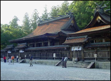
Hongo Temple The Kii Peninsula is the largest peninsula on the island of Honshu in Japan. Named after the ancient Kii Province, it is mostly occupied by Wakayama Prefecture, including the entire southern part. To the northwest of Wakayama Prefecture is Osaka Prefecture, whose southern part is on the peninsula. East of Osaka Prefecture is landlocked Nara Prefecture; farther east is Mie Prefecture. The Seto Inland Sea lies to the west of the Kii Peninsula. To the south and east is the Pacific Ocean and to the north is Ise Bay. [Source: Wikipedia]
The area south of the “Central Tectonic Line” is called Nanki. Waters off the coast here contain some of the northernmost reef-like warm-water coral communities in the world due to the presence of the warm Kuroshio Current. The Kuroshio’s also has string impact on the climate of Nankii, one of the wettest place on Earth’s outside the tropics with rainfall in the southern mountains reaching five meters (200 inches) per year and averaging 3.85 meters (151.6 inches) in the southeastern town of Owase, comparable numbers to wet parts of peninsular Alaska and southern Chile. Kii Peninsula is also one of the most adversely affected areas of Japan when typhoons strike, sometimes dumping almost a meter of rain in a 24 hour period. The area is also vulnerable to tsunamis from devastating Nanki trough earthquakes
Most of the Kii Peninsula is dense temperate rainforest since the climate even in the limited lowlands is too wet for agriculture, and much of the coast consists of networks of small rias (long, narrow inlets formed by the partial submergence of a river valleyes) into which flow very steep and rapid streams with numerous high waterfalls. Forestry and fishing have traditionally the main economic activities and remain important as declining population and labor force declines.
Kii Mountain Sacred Sites and Pilgrimage Routes: UNESCO World Heritage Site
Kii Peninsula embraces Wakayama, Mie, and much of Nara prefectures. It is the home of Mt. Koya, Yoshino, the Kuramo pilgrimage trail, Ise shrine and the hot springs of central Wakayama. Sacred Sites and Pilgrimage Routes in the Kii Mountain Range Nara, Mie, Wakayama prefecture were declared a UNESCO World Heritage Site in 2004 According to UNESCO: “Set in the dense forests of the Kii Mountains on a peninsula in the southernmost part of mainland Japan, overlooking the Pacific Ocean, three sacred sites – Yoshino and Omine, Kumano Sanzan, and Koyasan – are linked by pilgrimage routes to the ancient capital cities of Nara and Kyoto. Together these sites, the connecting pilgrimage routes, and surrounding forests form a cultural landscape that reflect the fusion of Shintoism, rooted in the ancient tradition of nature worship in Japan, and Buddhism, which was introduced from China and the Korean Peninsula. [Source: UNESCO]
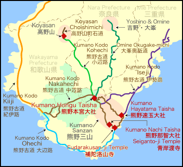
Kii Peninsula with
the Kumano Trail “The sacred sites are connected by 307 kilometers of pilgrimage routes which cover a total area of 506.4 ha. With the surrounding forest landscape, they reflect a persistent and extraordinarily well-documented tradition of sacred mountains maintained over 1,200 years. The area, with its abundance of streams, rivers and waterfalls, is still part of the living culture of Japan and is much visited for ritual purposes and hiking, with up to 15 million visitors annually. Each of the three sites contains shrines, some of which were founded as early as the 9th century.”
The site is important because: “1) The monuments and sites that form the cultural landscape of the Kii Mountains are a unique fusion between Shintoism and Buddhism that illustrates the interchange and development of religious cultures in East Asia. 2) The Shinto shrines and Buddhist temples in the Kii Mountains, and their associated rituals, bear exceptional testimony to the development of Japan’s religious culture over more than a thousand years. 3) The Kii Mountains have become the setting for the creation of unique forms of shrine and temple buildings which have had a profound influence on the building of temples and shrines elsewhere in Japan. 4) Together, the sites and the forest landscape of the Kii Mountains reflect a persistent and extraordinarily well-documented tradition of sacred mountains over the past 1,200 years.”
“The property consists of three sacred sites including precincts and buildings of temples and shrines in the heavily forested Kii Mountains, and a complex pattern of tracks and paths that link the sites together. These component parts are essential for demonstrating the religious framework of Shintoism (rooted in the ancient tradition of nature worship in Japan), Buddhism (introduced to Japan from China and the Korean Peninsula), and Shugen-dô (the Shugen sect) which was influenced by the former two faiths. The three sacred sites with their surroundings demonstrate high degree of integrity. Also the pilgrimage routes, as part of the extensive cultural landscape, at present retain a significant degree of integrity.”
Yoshino
Yoshino (one hour from Osaka by train) is the Kansai area's most famous cherry blossom viewing area and one of the region’s prime hiking areas. Believed to be a homeland for kami (spirit gods), it is also a center of ascetic religious practices associated with mountains. In the old days Mt. Yoshino was a retreat for ascetic Buddhists and has temples associated with Emperor Gadiago and Yoshitsune Minamoto.
There are some 20,000 cherry trees spread across five miles of ridges on northern end of the Omine Mountain Range. The blossom’s gradual change from the bottom to the top of the slopes of the mountainous is known as “Shimo Senbon” and “Naka Senbon” . It has been said people have been coming here since the Heian Period to view cherry Blossoms. In most years the prime cherry blossom-viewing season is in early April.
In 2004, the Yoshino Omine area was named a UNESCO World Heritage Site. The mountains in the Yoshino area have rugged peaks and spectacular cliffs. The scenery around Miyataki, where a 7th century imperial palace once stood, and Lake Tsuburoko is stunning.
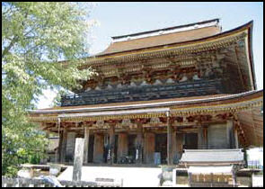
The main tourist sights in Yoshino are Kinpusenji Temple and Yoshimizu Shrine. Kinpusenji Temple, which according to legend was built during the Asuka period as a training center for the Shugendo school by Enonogyoja, a legendary ascetic. Zaodo, the main hall at Kinpusenji Temple, is the largest wooden structure in Japan after the Daibutsuden at Todaiji Temple.
Yoshimizu Shrine was the temporary palace of the Emperor Godiago and a hideout for Yoshitsune, a tragic hero for the Genji family who hid himself from his brother Yoritomo.
Websites:Nara Prefecture tourism site Visit Nara ; Japan Guide japan-guide.com Getting There: Yoshino is accessible by train from Nara, Kyoto, and Osaka and other Japanese cities. Lonely Planet Lonely Planet
Tsubosaka-dera Temple (in Yoshino) is a scenic temples you can have all to yourself at night. After closing hours, let a monk take you on an exclusive tour of this magnificent temple, which overlooks Mount Yoshino, long Japan’s most famous cherry blossom viewing spot. You’ll learn about the temple’s history, don traditional dress, take part in a Buddhist prayer session and receive a good-luck talisman. All that remains is exploring the grounds to your heart’s content before an enchanting and otherworldly night. Group reservations are welcome. Location: 16 3 Tsubosaka, Takatori-cho, Takaichi-gun, Nara; nara-experience.com
Yoshino-Kumano National Park
Yoshino-Kumano National Park (southeast of Nara) embraces the two mountainous districts of Yoshino and Kumano, both of which are rich in gorges, picturesque mountains, seascapes, and ancient temples and shrines. The park covers an area of 614 square kilometers in Mie, Nara, and Wakayama Prefectures on the Kii Peninsula. Its varied landscapes consist of mountains, rivers, and beaches and encompasses the Omine Mountain Range, known as the Roof of the Kinki Region. The region stretches from north to south in the center of the peninsula with Odaigahara Plateau to the east; the Osugi Valley and the Kumano River from its source in these mountains to the Kumano-nada Sea; the middle and lower basin of the Kitayama River; the coastal line overlooking the southernmost Kumano-nada Sea from Owase to Cape Shionomisaki; and Mt. Nachi, which was protected over its long history by those who worshipped Kumano. [Source: Ministry of the Environment Government of Japan]
From the subtle and profound mountains, deep valleys to the southern sea where the Japan Current flows, it is hard to beat this park for diversity. A portion of the area is designated a World Heritage site, named the "Sacred Sites and Pilgrimage Routes in the Kii Mountain Range" and a part of the northern area is designated as a UNESCO Eco Park aimed at the harmonization of preserving the ecosystems and ensuring sustainable utilization, as well as the Nanki Kumano area in Wakayama Prefecture is registered as the Japanese Geopark.
The main draws to this area include the forest region around Kawakami Village, Kitayama-kyo Gorge and Mt. Odaigaharayama, whose top is occupied by a moss- and bamboo-covered plateau. The plateau received 500 centimeters of rain a year. When the clouds clear there are wonderful views of Ushiishigahara, Masakigahara, and Daijagura. The summit of Odaigahara and 1,695-meter-high Hidegadake, are good place to see autumn leaves. Most years the leaves begin changing around October 10 to 15. Warm weather in recent years has delayed the season by around 10 days.
Accommodation Areas: Oodaigahara, Yoshinoyama, Oomine range, Kumano Sanzan, Kumano-nada sea, Karekinada Coast-Shirahama, Tanabe Bay Getting There: From Tokyo Station take the Tokaido/Sanyo Shinkansen about one hour 40 minutes to get to Nagoya Station. From there take JR Limited Express about three hours and 25 minutes to get to Shingu Station. From there take JR Kii Main Line about 16 minutes to get to Ugui Station. From there take a taxi about 5 minutes to get to Ugui Visitor Center 2) From Tokyo Station take the Tokaido/Sanyo Shinkansen about one hour 40 minutes to get to Kyoto Station. From there take Kintetsu Kyoto Line Limited Express about 50 minutes to get to Kashihara-jingu Station. From there take Kintetsu Yoshino Line Limited Express about 50 minutes to get to Yamato-Kamiichi 3) the Nara Kotsu Bus takes about one hour 45 minutes to get to Oodaigahara Bus Stop. Websites: Japan National Parks env.go.jp ; Wakayama Prefecture tourism site visitwakayama.jp
Odaigahara Visitor Center is located at the entrance to these forests, and provides information about the many attractions of the natural environment and history of Odaigahara Plateau, as well as about seasonal sightseeing spots. Location: Kotochi 660-1, Kamikitayama Village, Yoshino County, Nara Prefecture, Tel: 07468-3-0312; Hours Open: 9:00am-5:00pm ((When the Odaigahara Driveway is open; closed when National Route 169 or the Odaigahara Driveway are closed due to rainfall regulations), Closed Closed during winter (late November-late April)
Mountainous Area of Yoshino-Kumano National Park
The Omine Mountain Range is a mountainous region representative of the Kansai region consisting of mountains rising 1,500 meters to 1,900 meters above sea level extending from north to south that includes Mt. Inamuragatake, Mt. Sanjogatake, Mt. Daifugen, Mt. Gyojagaeri, Mt. Misen, Mt. Bussho, Mt. Shakagatake, Mt. Dainichi, and Mt. Tengu with Mt. Hakkyogatake (1,915 meters) as the highest peak. [Source: Ministry of the Environment Government of Japan]
The area around Odaigahara Plateau is a non-volcanic elevated peneplain consisting of sedimentary rocks in the paleozonic strata, and Mesozoic strata, which is rare in Japan for having a vast flat topography, are found at around 1,500 meters above sea level. The Higashinokawa River running through the area creates a deep V-shaped valley with a series of waterfalls and rock cliffs.
With annual rainfall of over 3,500mm, Odaigahara Plateau has the highest rainfall in Honshu (Japan's Main Island). The area has preserved forest ecosystems that are native to Kii Peninsula, including spruce forest that have captured climatic changes since the ice age and Asia-Pacific-type Japanese beech forests that are found in compact areas. The visitor center
The Osugi Valley is situated in the east of Odaigahara Plateau where the side of aqueous rock walls are largely eroded and the streams flow downward. There are also a hundred small and large falls and deep pools along the Osugi Valley including Senpironotaki Falls, Nikoniko Falls and Nanatsugama Falls.
Mt. Nachi Area is a mature mountainous region that consists of Mt. Myoho and Mt. Eboushi and it was formed after granite porphyry intruding into a tertiary deposit remained due to the delayed encroachment compared to other mountains. The famous Nachi Falls, the tallest waterfall found in Japan with a height of 133 meters, flow down the face of a steep cliff between both geological layers.
Animals and Plants Yoshino-Kumano National Park
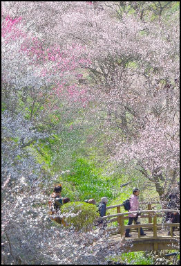
Yoshino cherry trees The east of Odaigahara Plateau (commonly known as the Nishiodai region) is an upheaval semi-plain where an extensive forest of Japanese beech trees grow. As an existing forest of beech trees along the Pacific seaboard of Japan, it is the largest forest in Japan and is thus considered precious as a research area. In addition, as with the Omine Mountain Range, there is the southern limit of spruce forest along the ridge line of Mt. Hidegatake. [Source: Ministry of the Environment Government of Japan]
The Omine Mountain Range is lined with Veitch's silver fir, Tsuga diversifolia, and spruce trees in the vicinity of the summit of Mt. Hakkyogatake and part of the area is designated a natural treasure. Affected by the Japan Current, this area is a suitable habitat for warm-season orchids and ferns, as well as the northern limit for Histiopteris incise, Asplenium antiquum Makino, Pteris fauriei, Ipomoea pes-caprae, Crinum asiaticum L. var. japonicum, Ipomoea indica, and other warm-season plants.
The natural forests on the hillsides of Odaigahara Plateau, Osugi Valley, and the Omine Mountain Range make for a perfect habitat for mammals, birds, and insects. In particular, the mammals found here are large animals including Cervus nippon, Capricornis crispus, and Ursus thibetanus, as well as small and medium-sized animals that include Macaca fuscata, fox, Sciurus lis, Lepus, Mustela itatsi, and Nyctereutes procyonoides, all of which are mostly the mammals living in Japan.
Mycena lux-coeli is a luminescent green mushroom. Frequently found growing on the decayed trunks of Castanopsis sieboldii between the middle of May and summer. The south-east of the Kii Peninsula is a major habitat of Mycena lux-coeli, and observation groups are met annually on the Ugui Peninsula (Nachikatsuura Town, Wakayama Prefecture).
Crinum asiaticum L. var. japonicum is a species of the cluster amaryllis family. Blooms in summer with a white flower. A cork-like seed, which floats in water and is distributed by sea currents. Distributed widely along the coast of the Kumano region.
Places in the Mountainous Area of Yoshino-Kumano National Park
Mt. Yoshino is famous as the finest site of wild cherry trees in Japan. Visitors are invariably captivated by the sight of the entire slope of the mountain gradually becoming tinged by the color of cherry trees in bloom from the bottom to top of Mt. Yoshino in spring. There is an observatory set up at a lookout point where visitors can behold the commanding views of Mt. Kongou and Mt. Katsuragi in a distance, as well as the townscapes around Mt. Yoshino surrounded by greenery.
Omine Mountain Range is a profoundly mountainous area known as the Roof of the Kinki Region and comprises, from north to south, a series of famous peaks: Mt. Sanjogatake (birthplace of the Shugendo school of Buddhism), Mt. Hakkyogatake (highest peak in the Kinki region), and Mt. Shakagatake (dominant peak of the southern part of this area). At present, in addition to spiritual mountain climbing centering on Mt. Sanjogatake, the mountains have been used in various ways including hiking and competitive mountain climbing.
Mt. Misen and Mt. Hakkyogatake feature temperate mixed needleleaf and broadleaf forests and subalpine coniferous forests grow in the Omine Mountain Range. These forests are habitat for a number of wild animals including endangered Asian black bears on the Kii Peninsula and Japanese serows that are designated a nationally protected species.
Odaigahara Plateau receives some of the highest amounts of rainfall in Japan, the area boasts average annual precipitation of approximately 3,500 millimeters. The precipices, waterfalls, and other formations created through erosion caused by heavy rains have created a majestic landscape. A scenic highway takes visitors near the summit to offer a full-fledged mountain climbing experience of a nature walk and hiking near the summit.
Nishi-Odai Area covers 450 hectares and is home to a wide variety of plants and liverworts, such as Japanese beech trees and Abies homolepis, besides serving as a habitat for numerous wild animals including endangered local populations of Asian black bears of the Kii Peninsula, sika deer, and other large animals. There are also living creatures named after Odaigahara such as Odaigahara Sanshouo (Hynobius boulengeri).
Yoshino Area Yamabushi
The Yoshino area, near Nara and Osaka, was a major yamabushi stronghold. The Kii mountain range here encompasses several peaks over 1,500 meters and stretches across the Kii Peninsula into the Yoshino area. Since ancient times, the mountains have been worshiped as a sacred place and have been the site of numerous shugendo ascetics’ practice.
Masahira Ueno wrote in Yomiuri Shimbun: Deep in the Kii mountain range, the sounds of horagai triton shell horns echo around Sho no Iwaya, a cave where mountain ascetics are said to have once spent the winters during their mountain-dwelling shugendo practice to develop their spiritual experience and power. Kumano Shugen, a group of about 30 mountain ascetics based at Seigantoji temple in the Kumano district of Wakayama Prefecture, visit the cave every December as the conclusion of that year’s shugendo practice. [Source: Masahira Ueno, Yomiuri Shimbun, January 28, 2014]
In the old days, yamabushi had to walk the 24 kilometer distance between Tenkawamaru and 1,719-meter-high Mt. Sanjodadake everyday for 100 days. During the first 50 days they were given two days to make the round trip During the second 50 days they had to the round trip trek in a single day, stopping at more than 20 small hokora shines along the route to chant sutras.
See Yamabushi Rituals Under YAMABUSHI, SHUGENDO AND MOUNTAIN ASCETICISM IN JAPAN factsanddetails.com
Rafting in Dorokyo Gorge
The area around Omine boasts Japan's highest amounts of rainfall, and Odaigahara Plateau collects the bounty of water while the Kumano River empties into the Kumano-nada Sea. The middle and lower basin of the subsidiary Kitayama River created a deep V-shaped valley through powerful erosion throughout the area. [Source: Ministry of the Environment Government of Japan]
The Dorokyo Gorge located midstream of the Kitayama River is a gorge situated downstream basin of the Kitayama River, which is a tributary of the Kumano River fed by waters flowing down from the Omine Mountain Range and Odaigahara Plateu. The gorge is divided into several sections from upstream to downstream: Oku-Doro, Kami-Doro, and Shimo-Doro. Shimo-Doro is also referred to as Doro-Haccho. This area features a diverse array of linked scenic elements consisting of vertically sheared cliffs created through the erosion of geological layers formed by the solidification of magma, oddly shaped rocks, and deep pools of water. Board a hovercraft or other vessel to explore the beautiful allure of this extraordinary gorge.
Doro-kyo Gorge (near Yumomine Onsen) is the site of a popular dramatic two-hour boat trip. The trip is done on glass roofed boats and cost about ¥3,300. Many people consider Doro-kyo Gorge to be one of the most beautiful gorges in Japan. Whitewater trips are done from Kamikitayama-mura to Dor-hatch via the Doro-kyo Gorge on unusual rafts on which riders stand up single file. Website: Totsukawa Area Visit Nara
Kumano Rafting is a 600-year-old Japanese tradition that offers exhilarating wet thrills Come to Kitayama, a historic village tucked away in the mountains of the Kii peninsula, and hop aboard a log raft for an exciting whitewater ride. Part of the Yoshino-Kumano National Park, Dorokyo Gorge is the ancestral home of the river runners—loggers who navigated the rapids long before roads were paved. Your guides will lead you downstream using the same techniques employed by their ancestors. You’ll laugh and scream with joy at every twist and turn of the rushing river, taking in breathtaking scenery along the way. Memories of this off-the-beaten-track adventure will stay with you long after your return home. Kitayama is located about 4 hours from Nagoya, or 5 hours from Osaka, by train and bus. Travelers are encouraged to arrive the night before and spend the night at the rustic Okutoro Onsen hot spring resort. Location: 1-20 Minato, Tanabe-shi, Wakayama; Website: Tanabe City Kumano Tourism Bureau kumano-travel.com
Kumano Nachi Taisha Area
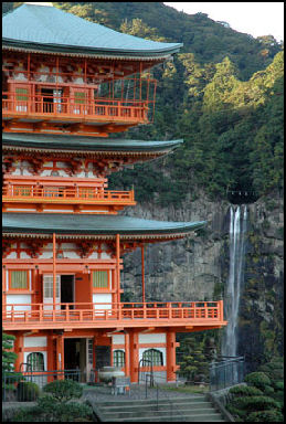
Shingu (on the Pacific Ocean in eastern Wakayama) is the home of Kumano Hayatama Taisha. The bright red and white buildings here houses more treasures than the other major Kumano shrines. Shingu can be reached by train and is a major transportation hub for eastern Kii Peninsula.
Kumano Nachi Taisha (near Shingu) is the most visited and picturesque of the three Kumano shrines. It is located next to 133-meter-high Nacho waterfall, the highest waterfall in Japan. Displayed around the main shrine are offerings — such as paintings, golden swords, tortoise shell combs, statues and bronze mirrors — brought to the shrine during the last 600 years.
The main temple is kind of cheesy and crowded with tourists. Some of the building have spectacular views of the waterfall. Hiking trails lead to other waterfalls in the area. In mid July there is a fire festival here in which participants carry flaming, 50-kilogram torches up a steep series of stone steps from the base of the waterfall to one of the shrine buildings. In late October priests perform a ritual in which they walk across the water just above the falls.
For a small donation you can get one of the shrine's vestal virgins to perform a sacred dance called the “kagura”. The virgin, dressed in a red kimono decorated with golden herons and carrying a baton with bells, performs the slow hypnotic dance to the music of flutes and drums. Website: Japan Guide japan-guide.com ; Photos taleofgenji.org
Conservation and Preservation of Kii Mountain Sacred Sites and Pilgrimage Routes
According to UNESCO: This extensive property is the responsibility of a number of different jurisdictions and is protected by several layers of legislation that permit integrated application of related measures. Basic principles and methodology for comprehensive preservation and management of the tangible cultural assets of each component parts are outlined in the 2003 Comprehensive Preservation and Management Plan. [Source: UNESCO]
“Due to a long tradition of reconstructing and renewing timber structures, the authenticity of each wooden building is well preserved from the view of form/design, materials/substance, traditions/techniques, and location/setting. At the three sacred sites, various religious rituals and practices mainly related to Shintoism, Buddhism, and Shugen-dô have been continually carried out. Such activities are still underway even now, and thus a high level of spiritual authenticity is maintained. These sacred sites and the forest landscape around them retain an extremely high degree of authenticity, in terms of not only tangible elements but also intangible elements represented by religious activities. The sacred sites and pilgrimage routes have attracted worshippers since the 11th or 12th centuries and have thus retained a high degree of authenticity of function.
“The buildings that constitute component parts of the property as monuments have been designated as National Treasures and Important Cultural Properties under the Japanese Law for the Protection of Cultural Properties. The temple and shrine areas, the pilgrimage routes, and the forest landscape around them have been designated as Historic Sites, Places of Scenic Beauty, and Natural Monuments under the same law. Thus, these component parts are rigorously preserved and activities such as alterations are strictly limited because they require the permission of the national government.
“The property includes areas designated as a National Park and Prefectural Natural Park under the National Parks Law, and thus the natural environment is well preserved because development such as construction of new buildings or tree-felling cannot be carried out without the prior permission of the national or prefectural government.
“All of the buildings and the grounds of the temples and shrines are well preserved through preservation and maintenance activities carried out by the relevant religious organizations. Yoshinoyama is preserved and maintained in collaboration with individual owners and local governments, in line with the management plan produced by the local Board of Education. The same applies to pilgrim routes which are preserved and maintained by private owners, local governments, and the national government. The national government can provide financial and technical support for restoration and repair projects on the basis of individual management plans.
“Each component part has a clear and adequate buffer zone designated under the National Park Law, the Forest Act, local government regulations, or the like. The Coordinating Academic Committee, with representatives from the Academic Committees of all three prefectures, works to facilitate proper communication and information sharing among relevant local governments. The Committee has approved a Comprehensive Preservation and Management Plan which is supported by the coordination of three supplementary Prefectural Plans. The status of preservation and management of the property is reported periodically in order to ensure it is fully implemented.”
Image Sources: 1) 8) Kumano Kodo site 2) 5) JNTO 3) 4) Wikipedia 6) 7) 9) 15) Wakayama Prefecture site 8) Kumano Kodo 10) 11) 12) Hongu Kumnao site 14) Wikitravel
Text Sources: JNTO (Japan National Tourist Organization), Japan.org, Japan News, Japan Times, Yomiuri Shimbun, Japan Ministry of the Environment, UNESCO, Japan Guide website, Lonely Planet guides, New York Times, Washington Post, Los Angeles Times, National Geographic, The New Yorker, Bloomberg, Reuters, Associated Press, AFP, Compton's Encyclopedia and various books and other publications.
Updated in January 2023
