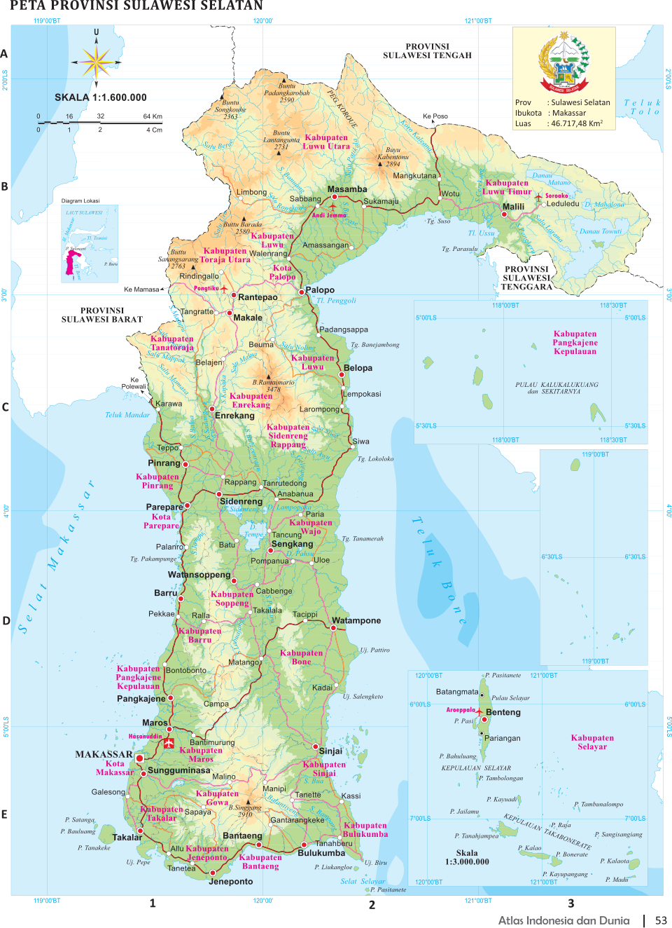
SOUTH SULAWESI
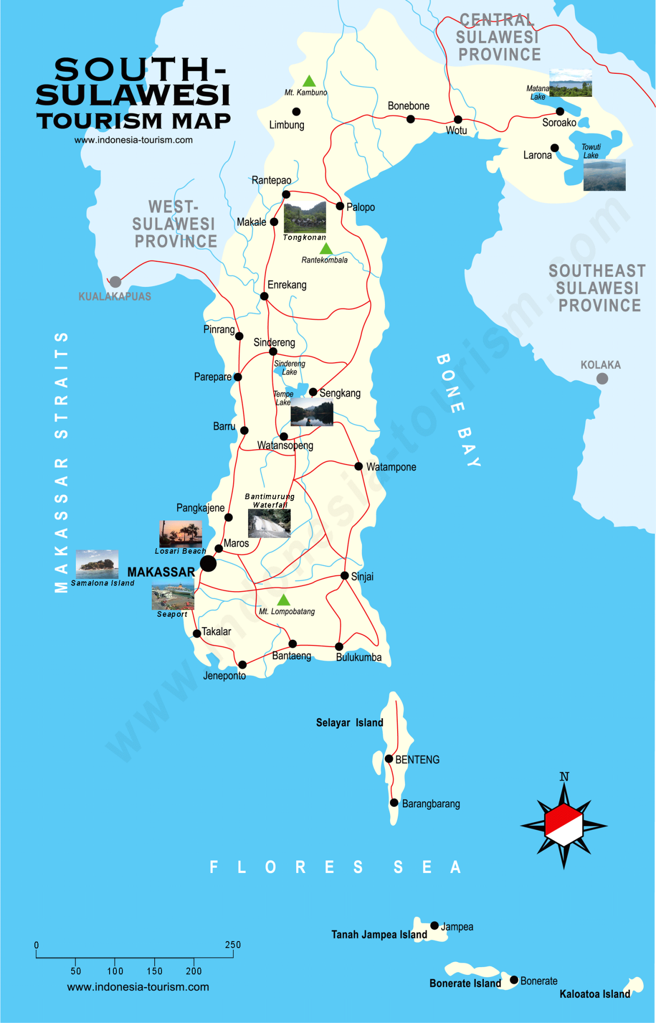
South Sulawesi is a mostly mountainous region best well known for the two unique cultures which inhabit it: the seafaring Bugis on the southern tip of the island and the Torajas who live in the rugged country further north and are known for their unusual customs. Bugis make up two thirds of he region’s population. The Makarese, another seafaring people, make up about a quarter of the population. South Sulawesi Province covers 46,717.48 square kilometers. Its population rose from 8,034,776 in 2010 to 8,395,747 in 2014. Its population density is 179.7 people per square kilometer.
South Sulawesi is regarded as the rice bowl of eastern Indonesia. The highlands in southern Sulawesi range in elevation from 300 meters to 2,884 meters. The rainy season in southern Sulawesi is from November until April.
Makassarese and Bugis are religious people, most are Muslims and are regarded as very strong minded. Bugis people are known for being among the best sailors in the world and have a tradition of piracy. Seafarers from Sulawesi — the Bugis, Bajau, Butonese and Makassarese — have traded with neighboring countries, most notably with the Australian Aborigines, for hundreds of years.
South Sulawesi food includes fresh seafood, Chinese food and coto makassar — soup made from cow innards. Sop saudara is similar to coto but it's more bland compared to coto. Konro or beef ribs soup is tasty and filling. For snacks you might want to try jalangkote, a kind of pastry with a tasty filling, eaten with a spicy sauce. For dessert, try pisang epe — flattened banana with palm sugar sauce, usually mixed with jackfruit or durian. Es pallu butung, made of sliced banana, ice chips, coconut milk and red sauce is also filling and refreshing. Pisang hijau is banana coated with flour and pandan leaves, thus causing the outer layer to turn green. It's sliced and then coated with cocopandan syrup.
RELATED ARTICLES:
ETHNIC GROUPS ON SOUTHERN SULAWESI factsanddetails.com
SOUTHERN SULAWESI: HISTORY, GEOGRAPHY, RELIGION factsanddetails.com
PEOPLE AND CULTURE OF SOUTHERN SULAWESI: LIFE, SOCIETY, BOATS factsanddetails.com
SOUTH EAST SULAWESI factsanddetails.com
SULAWESI factsanddetails.com
MAKASSAR HISTORY, GOWA, TRADE, RELIGION AND SIRI (HONOR) factsanddetails.com
MAKASSAR PEOPLE: LIFE, SOCIETY, CULTURE factsanddetails.com
MAKASSAR CITY AND REGION factsanddetails.com
BUGIS: LANGUAGE, HISTORY, RELIGION. ECONOMIC ACTIVITY factsanddetails.com
BUGIS LIFE AND CULTURE: SOCIETY, FAMILY, FIVE-GENDERS factsanddetails.com
BUGIS SAILING TRADITIONS: SHIPS, PIRACY, WHALE SHARKS factsanddetails.com
TORAJA: HISTORY, LANGUAGE, DEMOGRAPHICS, GROUPS factsanddetails.com
Travel to an Around South Sulawesi

Ricefield in Manipi Town, Sinjai Regency, South Sulawesi
There are many flights and daily service from Jakarta, Bali, Surabaya and Manado to Makassar, the main city in South Sulawesi. There are some good asphalt roads in many places but the roads wind up and down slopes in mountainous areas and traveling can take a while. Tourism Office: JL. Jend. Sudirman No.23, Makassar 90231, Tel. (62-411) 878912, 443355, 872336, fax: (62-411) 872314, E mail: disbudpar-sulsel@telkom.net, Website: phinisiq.com
Daniel Stables of the BBC wrote: A serene old lady and a clucking chicken were my travel companions in a battered sky-blue bemo (public minibus) as I left Makassar behind. As we rattled north, jagged shards of limestone karst, tufted with jungle, lurched skyward from the surrounding rice paddies. It was planting season, and we passed a field where a mechanical plough was being pushed along, preceded by a ritualistic parade of bissu, recognisable by their robes of red, gold and green and their headdresses adorned with colourful flowers. We drove on. The evening sun began to glow like coal, and the Bugis farmers, bending to tend the rice fields, cast hunched and lengthening shadows. [Source: Daniel Stables, BBC, April 13, 2021]
Bantimurung National Park
Bantimurung National Park (50 kilometers north of Makassar and 20 kilometers from the Sultan Hasanuddin international airport) is famous for its stunning waterfalls, interesting caves and plethora swarms of butterflies. In 1857, the famed British naturalist, Alfred Russell Wallace visited this area and was amazed by butterflies he saw here in terms of numbers, sizes, colors and variety. Fascinated by what he saw he dubbed the area “the Kingdom of Butterflies” and helped identify some of the 150 species of butterflies found in South Sulawesi and nowhere else in the world. The official website for the park — tn-babul.org — is in Bahasa Indonesian.
The Bantimurung National Park has a total area of 43,750 hectares and is divided into three major types of ecosystems: the karst ecosystems, a lowland forest ecosystem, and a lower montane forest ecosystem. The valleys have limestone hills and steep karst walls with tropical vegetation. The word Bantimurung itself is derived from two Bugis words: Benti meaning water, and Merrung meaning roaring, perhaps a reference to the waterfalls found here. Bantimurung Waterfall described above is situated not too far from the park entrance.
Although there are not as many butterflies today as there were during Wallace’s expedition, visitors can still observe the wide variety of butterflies within the Butterfly Conservation Captivity managed by the Center for Butterfly Breeding. Among various species of butterflies found here are: the Troides halipron, Papiliio Pofites, Papiliio Satapses, Papiliio blumei and Graphium androcles. One of the rarest and biggest butterflies of the world, the papillo androcoles are also found in this National Park. This unique species has the tail similar to swallows. Within the national park, visitors can also find a butterfly museum which houses thousands of unique and rare butterflies that have and still inhabit the area. Among other fauna found in the area are: the Kuskus (Phalanger celebencis), Tarsiers (Tarsius sp.), Monkeys (Macaca Maura), hornbills (Ryticeros cassidix, Peneloppides exahartus), and Weasels (Macrogofidia mussenbraecki).
The hills of Bantimurung-Bulusaurung National Park are the home of karst formations and caves. The most notable of these caves are the Goa Mimpi (Dream Caves) and Goa Batu (the Stone Cave). The inside these caves filled with fascinating stalactites and stalagmites. The dreamlike crystal clear stalactites and stalagmites found in Goa Mimpi earned that cave its popular name. Among these caves are found prehistoric “hand stencils”, dated to 37,000 years ago and regarded as the some of the world’s oldest art, older than the famous cave art in France Hiking up 10 meters of stairs, visitors can discover another amazing cave, the Stone Cave, or Gua Batu, with a small waterfall and a 30-meter-long intriguing cave.
Accommodation: If you plan to stay a little longer, there are several bungalows and modest inns near the entrance of the Bantimurung Bulusaraung, with price ranging from IDR 50.000 to IDR 80.000. With only less than two hours drive from Makassar, it is more comforting if you stay in a hotel in Makassar. Find a Hotel in Makassar
Getting There: Located only 20 kilometers from Hasanuddin Airport, the national park can be reached from the airport by local public transportation called pete-pete for about 30 minutes. The pete-pete will charge about IDR 5.000. If you travel from Makassar, you can catch a public bus or DAMRI, from the Makassar Mall in the direction of Maros for about one hour and costs IDR8.500. From Maros, take the same pete-pete that also goes to the airport.
Prehistoric Cave Sites in Maros-Pangkep
Prehistoric Cave Sites in Maros-Pangkep (Bantimurung National Park) was nominated to become a UNESCO World Heritage Site in 2009. According to a report submitted to UNESCO: “In general, the karst landscape is hilly and has mountainous terrains. The mountainous area is situated in the north east or located in the Bulusaraung Mountains. The highest peak of the mountain is 1,565 m above sea level in the northern side of Bulusaraung Mountain. This side of the mountain has a steep slope with rough texture. The climate in the Maros Pangkep area is tropical with the dry season between the months of November to April meanwhile the rainy season runs from May to October. The temperature ranges from 210 C - 310 C or on average 26.40 C, with fluctuating humidity. The area of the Pangkep conservation forest covers around ± 21.631 hectares from the total forest area of 32.503 hectares. Most of the conservation forest is within the karst area that is part of the National Park of Bantimurung and Bulusaraung (Babul). [Source: Ministry of Culture and Tourism of the Republic of Indonesia]
“In the Karst Maros-Pangkep Area there are various types of flora among others: Bintangur (Calophyllum sp.), Beringin (Ficus sp.), Enau (Arenga pinnata), Nyato (Pala quium obtusifolium), and several from the familiy of Homalanthus, Lagerstroemia, Pterospermum, Kleinho via, Villebrunea and numerous endemic flora among others the Sulawesi black wood (Diospyros celebica) and Sepang wood or Sappang (Caesalpina sappan) which is used by the local people as a drink mixture. The typical wild fauna that are endemic found by researchers and biologists from the Indonesian Institute of Science and from France are among others the Black Monkey (Macaca maura), the Sulawesi possum kuskus (Phectarelanger celebencis), the Sulawesi civet weasel (Macrogolidia mussenbraecki), deers (Cervus timorensis), the black Enggang bird (Hectarelsion cloris), Swiftlet swallows (Aeroramus fluaphectaregus), Bats (Megachiroptera), butterflies (Papilio blumei, Papilio satapses, Troides hectarelipton), various types of amphibia and reptiles such as the python snake (Phyton), Leaf snake, Large Lizards (Paranus sp.), cave bees (Eustra Saripaensis), Troides helena reticulates Cave crabs (Cancroecea Xenomorpha Ng.), Cave scorpions (Chaerilus Sabinae Lourenco) and several aquatic fauna such the Isopoda Aquatic and Cirolana Marosina.
In this region there are hundreds of caves with stalagtites and stalagmites, of which 89 of them are prehistoric caves that contain prehistoric Rock Art Painting, prehistoric stone tools, kitchen waste consisting of shells from an ancient Mollusca. The Karst Maros-Pangkep Area covers an area of 43,750 hectares that comprises of a mining area of 20,000 hectares and the remaining 23,750 hectares are part of the conservation area of the National Park of Bantimurung Bulusaraung.
Traditions of the People Living in Maros-Pangkep
One the lifestyle and customs of the people living in the Marcos-Pankep area, UNESCO reported: “The people already have skills to make woven mats, woven containers for cooked rice, head covers (saraung), rice covers, hats baskets, to produce brown sugar and other products. The main ingredients and tools to make these products are derived from surrounding environment, such as the leaves of a certain palm tree (enau), rumbia leaves (for sago), palm leaves to be woven into mats, meanwhile the brown sugar is made from the flower sap of a special type of palm tree (lontar and enau).
“b. The tradition to go down to the paddy fields: Similar to the agrarian people of South Sulawesi, the people of the Maros-pangkep also have a tradition to go down to the paddy fields. The ritual starts from the tudang sipulung, choosing the seedlings, planting the seedlings, weeding the paddy fields, maddongi, and the tradition of mappadendang. The tradition of Mappadendang follows several steps and the most interesting part is at harvest time when the young start mating and finally marry.
“c. In addition to these traditions, there are also cultural arts from the region namely the traditional dances. From the Maros Regency tehre are traditions and dances such as the Ma'raga dance, Mappadendang dance, Ma'kampiri dance, Salonreg dance, Pepe-pepe dance, mamuri-muri dance, Tubaranina dance, Marusu dance, and the celebration the Muharram month, and the birth of the prophet Muhammad, Appalilli, Katto Bokko, Decorated boat competition, Mallangiri, Kalubampa Dance, and Kesong-kesong dance.”
Leang Timpuseng Cave: Home of Some of World’s Oldest Art
Leang Timpuseng Cave (in the Maros-Pangkep karst area) is the home of the world's oldest hand stencils, regarded as some of the world’s oldest art. Dated to 37,900 B.C., site also includes some of the most ancient animal paintings. The paintings were made with the natural mineral pigment ochre — probably ironstone haematite — which the hunter-gatherers ground to a powder and mixed with water or other liquids to create paint. As of 2014, researchers dated 12 hand stencils and two figurative paintings of animals in seven caves near Maros.
Inside Leang Timpuseng cave, Jo Marchant wrote in Smithsonian magazine: “Scattered on the walls are stencils, human hands outlined against a background of red paint. Though faded, they are stark and evocative, a thrilling message from the distant past. My companion, Maxime Aubert, directs me to a narrow semicircular alcove, like the apse of a cathedral, and I crane my neck to a spot near the ceiling a few feet above my head. Just visible on darkened grayish rock is a seemingly abstract pattern of red lines. Then my eyes focus and the lines coalesce into a figure, an animal with a large, bulbous body, stick legs and a diminutive head: a babirusa, or pig-deer, once common in these valleys. Aubert points out its neatly sketched features in admiration. “Look, there’s a line to represent the ground,” he says. “There are no tusks — it’s female. And there’s a curly tail at the back.” [Source: Jo Marchant, Smithsonian magazine, January-February 2016]
See Separate Article:
EARLY HUMANS IN SULAWESI, INDONESIA AND THEIR 45,000-YEAR-OLD CAVE ART factsanddetails.com
Bugi Area in Southeast Sulawesi
Bira (150 kilometers southeast of Makassar) is one of the best places for seeing Bugis and their wooden ships, and is perhaps the world’s last great place where wooden ships are made. At Marumasa and Tanah Beru near Biri you can see traditional boats of various sizes in various stages of construction. The stilted houses are painted in bright colors and decorated with pictures of dragons and flying creatures with propellers. Marumasa Bira is also famous for its pythons. There are some nice beached nearby.
According to the ancient I La Galigo manuscript, phinisi schooners have been built since the 14th century. These schooners are mostly crafted in the area called Tanah Beru, located about 23 kilometers from the capital of Bulukumba, or 176 kilometers from Makassar. Along the shores of Tanah Beru, you will see tens of dry-docks where phinisi schooners are in various stages of construction. Here the skillful hands of the Bugis with amazing precision, carefully craft the Phinisi that has become the icon of Indonesian seafaring. The Phinisi is built using traditional equipment following exact prescribed traditional techniques that have been passed down from generation to generation. Its construction does not only involve strength and technique but also — as the locals believe — supernatural powers, for which every stage requires strictly adhered rituals and ceremonies.
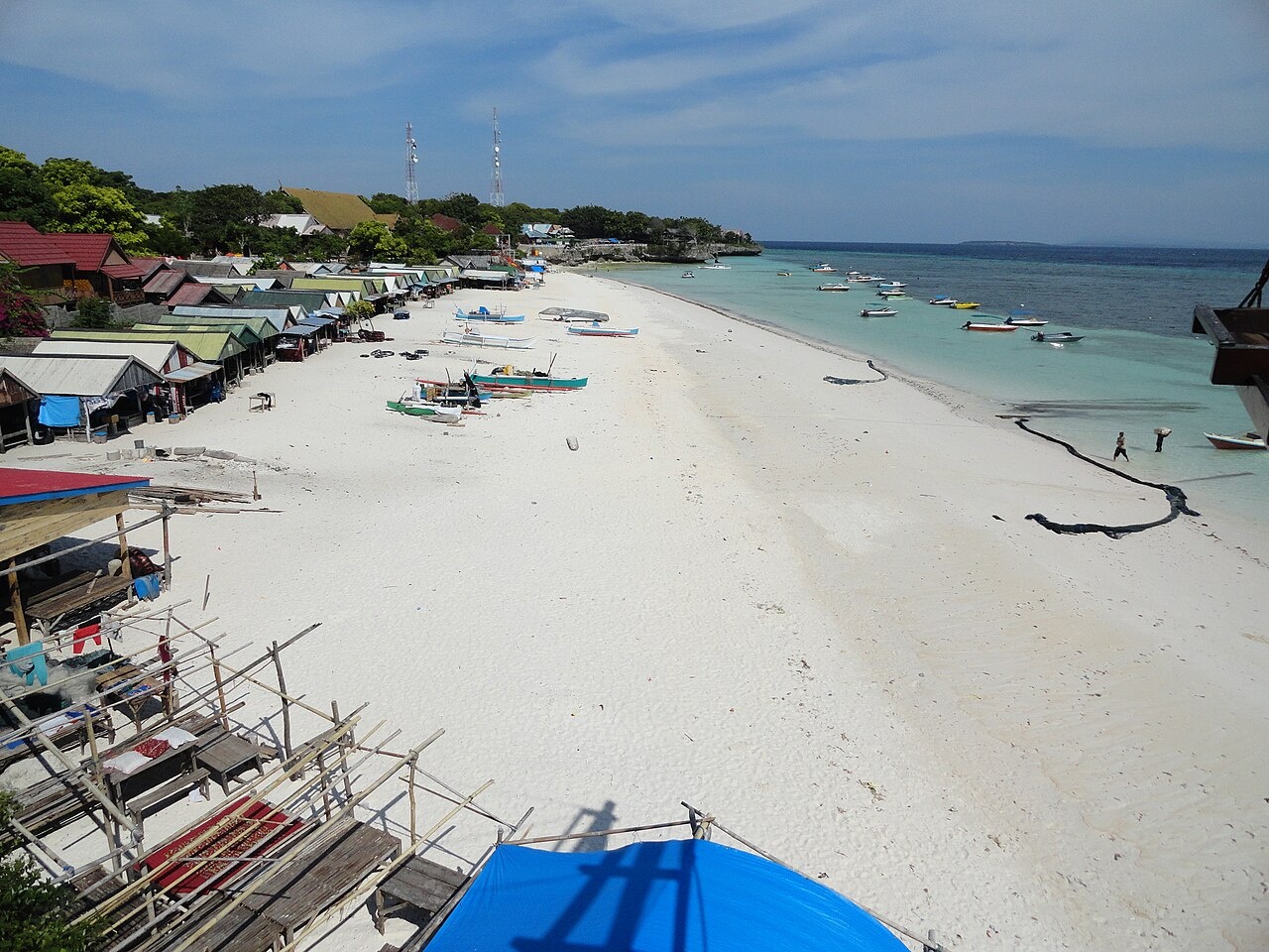
Further south, at the most southern tip of the district, about 200 kilometers from Makassar, the secluded white sandy beach and crystal clear calm waters at Tanjung Bira Beach. Its location alone has made it a special place, where the sun rises and sets magnificently along a straight line. Here you can find the luxurious Amatoa Resort, located on a vast spreading white sand beach, ideal for sunbathing, snorkeling and diving. There are also so me islands offshore that have nice reefs for diving.
There are also some places important in Bugi history. The word “Bulukumba” is believed to be derived from the Bugis phrase “Bulu’ku Mupa”, which loosely translated means “still my mountain”. The name appeared in the 17th century, when a war broke out between two kingdoms of South Sulawesi, namely the kingdoms of Gowa and Bone. At the time, the ridge of Mount Lompobattang, known as “Bengkeng Buki”, - which means “foot of the hill”, - was claimed by The Gowa Kingdom. The Bone Kingdom, however, refuted the claim and defended the area with all they had. From this battle came the passionate outcry: ”bulu’ku mupa!” or “still my mountain”. Gradually its pronunciation shifted to cover the entire area of Bulukumba.
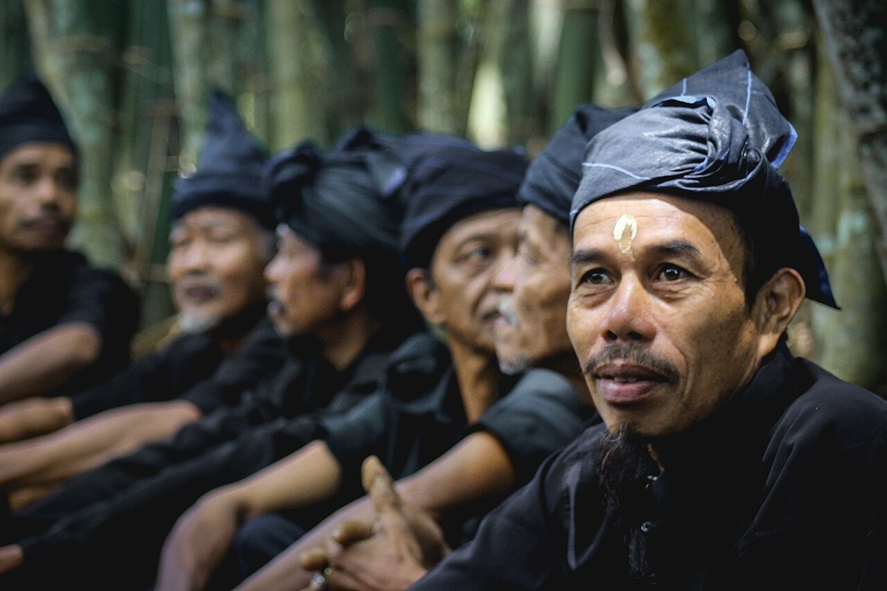
Bulukumba is also the home of a special ethnic group called the Kajang. For centuries they inhabited the interior area of the Kajang regency in an area called Tana Toa, which they regard as having been bestowed to them by their ancestors. Until this day, the Kajang still practice age -old traditions and ways of life that teach men to maintain perfect harmony with nature. Living in simplicity, none of the houses have any furniture, electricity, and other modern convenience.The Kajang also wear black as their daily attire. For to the people of Kajang, modernity deviates from customary rules and ancestral teachings.
Bouton Island (south of eastern Sulawesi) is famous for its golden-robed sultan, his lovely daughters in sarongs made with silver thread, and five miles of fortified ramparts from a Portuguese fort. Visitors are sometimes welcomed to the sultans court with a banquet in the main hall of the palace and music from gongs and drums. The beautiful women have a reputation for possessing magic which can make men never want to leave the island.
Accommodation and Getting to Bira and Bulukumba
The selection of available accommodation in the district of Bulukumba varies from star-rated hotels and resort to modest inns and backpacker’s lodge. Here are among some of the accommodation you can find in Bulukumba: 1) Salassa Guesthouse, Internet, cafe, restaurant, tourist information, motorbike and car rental; 2) Tanjung Bira Inn, AC, breakfast. 085824635570 24hours; 3) Pasir Putih Bira Inn, 0811 420 1028; 4) Kalubimbi Cottage. Bira. 085656 456 853; 5) Ala Din Homestay. 085 299 7021 68|0815 4328 8159; 7) Riswan Bungalows, , Banana boat, 085 341 664 955; 8) Nusa Bira Indah Cottage, Jl. Kapongkolang; 9) Bukit Sawerigading Inn, 081342242318;
10) Bira Beach Hotel and Restaurant, Jl. Kapongkolang No. 2, +62 413 270 2034; 11) Hotel Sapolohe, Right at the coast of pasir pUtih Beach; 12) Anda Beach Hotel and Restaurant, +62 413 258 9065|+62 81 355 963 628; 13) Bahagia Pondok Wisata Hotel, Jalan Bira, Bulukumba 92571, South Sulawesin Indonesia, Tel. (0413) 83599; 15) Awal Fajar Inn, Jl Pisang 19,, nBulukumba 92511, South Sulawesi, Indonesia. Tel: 0413-81267; 16) Anda Bunglows, Jl. Kapongkolang No. 6 Bira, Tel. (0413) 82125; 17) Bira View Inn, Tel. (0413) 82043 - 81763 Representative in Makassar: Tel. (0411) 867336; 18) Wisma Andita Beach, Jl. Yos Sudarso No. 4C, +62 413 81915, Very homey, comfortable, AC, cable TV, shower, breakfast. Room: Rp 200,00.
Getting There: From Malengkeri terminal in Makassar visitors can choose to take a bus or other public transportation to Bulukumba. By public transport, the trip to Bulukumba will take about 2 -3 hours and costs around IDR 35.000. Once you reach downtown Bulukumba, you can get to Bira Beach by taking the pete-pete minibuses for about IDR 8.000 to IDR 10.000. The Tanah Beru phinisi dock yards are along this road.In Tanjung Bira Beach, public transport operates only till the afternoon. If you wish to return to Makassar, there are also cars for hire to take you back to Makasar for about IDR 500.000
Taka Bonerate National Park
The Bonerate National Park (8 hours by bus plus, 8 hours by boat from Makassar) is home to the third biggest atoll in the world after Kwajifein in the Marshall Isles and Suvadiva in the Maldives. The park was nominated to become a UNESCO World Heritage in 2005. According to a report submitted to UNESCO: “The total area of the atoll is about 220,000 hectares with coral reefs spreading over 500square kilometers. The national park includes an area of 530,765 ha. Taka Bonerate is a Bugis’s name that somewhat has a meaning ‘Coral Piled Up On Sand’. There are 15 islands in taka Bonerate National Park where visitors can enjoy diving, snorkelling and marine tours. Stretching south of the main island of Sulawesi into the Flores Sea, the Taka Bonerate National Park in the Selayar Regency is a dominantly rich marine park, but it is also habitat to a number of bird species from land birds to coastal and sea birds that frolic on the many sand dunes. [Source: Ministry of Environment, Indonesia]
The Island of Selayar is the gateway to Taka Bonerate National Park. Taka Bonerate, together with Wakatobi , Ambon , Banda and Raja Ampat , together with Bunaken as well as the Derawan islands in Kalimantan, are at the heart of the Coral Triangle which stretches from the Solomon Islands in the east, to the Philippines in the north, to Bali , Lombok , Komodo , Flores and the Savu Sea in the south, these latter form the base of the huge Coral Triangle. Besides atolls, this national park comprises 21 islands.
The island of Tinabo, which is at the heart of Taka Bonerate is also headquarters of the management of this marine park. Measuring 1.5 km by 400 meters, Tinabo is far away from the hustle and bustle of city life, where it feels like you are on your own private island in the middle of nowhere. Here you can enjoy snorkeling, scuba diving, take a leisurely walk on the white sand beach, canoe, go fishing, or just watch in awe the sun rise in the morning, or in the evening set slowly behind the horizon in fantastic hues of orange and purple.
The crystal clear waters offer a wide range of reefs, from barrier reefs to fringing reefs and atolls to steep drop-offs, as well as slopes and flat seabeds, all offering opportunities for beginners to professional divers to test their skill and be amazed by the wonderful beauty of this underwater sea life. Besides the 242 species of corals, Taka Bonerate boasts 526 species of colorful and strange reef fish as well as 112 species of macro algae.
Divers will be able to get close and swim with dolphins, turtles, manta rays, sometimes spot sharks, or sperm whales, and be enthralled by the giant gorgonian fans, black corals, scorpion fish, nudibranch, tuna, trevallies, napoleon wrasse and more that make up this unbelievable,pristine underwater paradise. You will also find hawksbill turtles (Eretmochelysimbricata), Pacific Ridley turtles ( Lepidochelysolivicea), and green turtles (cheloniamydas). Indeed, Taka Bonerate is said to have one of the world's highest marine diversity. The Park has over 50 fantastic dive sites, a number are by the island of Tinabo, others are near the islands of Kahabia, Belang-Belang, and Taka Lamungan.
Best time to dive is between April to mid-May, and October to mid-November when the soft easterly winds do not whip up the waves. Winds are still reasonable between October through May. But during the west monsoon winds are liable to cause waves to two meters or higher. All ferries will stop operation when waves are dangerously high. The local population, who lives mostly on and around the island of Selayar are predominantly Bugis, known for their superb craftsmanship in boat building, and the Bajau sea gypsies.
To get to Selayar you must first reach Makassar or fly to Aeroppala Airport on Selayar Islands. Wings Air flies daily between the Sultan Hasanudin International Airport in Makassar and the Aeroppala Airport on Selayar Islands. Alternatively, youcan travel overland from Makassar to the town of Tanjung Bira and then take the ferry from Tanjung Bira's port to Selayar. If you want to use public transportation, best take an air-conditioned bus from Makassar that leaves at 9:00am. The route goes via the town of Bira at Bulukumba Regency, where the bus will be loaded on the ferry to cross to Selayar. From Selayar it still takes some 8 hours by boat from the town of Benteng to the island of Tinabo. Garuda Indonesia is scheduled to soon start operating Makassar - Selayar flights which will definitely shorten travel time and increase convenience.
Image Sources: Wikimedia Commons, Indonesia Tourism website, Wikpedia
Text Sources: Indonesia Tourism website (indonesia.travel), Indonesia government websites, UNESCO, Wikipedia, Lonely Planet guides, New York Times, Washington Post, Los Angeles Times, National Geographic, The New Yorker, Bloomberg, Reuters, Associated Press, AFP, Japan News, Yomiuri Shimbun, and various books and other publications.
Last updated in January 2026