GEOGRAPHY AND AND CHINESE HISTORY
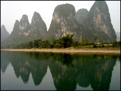
Guilin area of southern China
Dr. Robert Eno of Indiana University wrote: “China today is roughly the size of the continental United States, located at comparable latitude on the globe. Unlike the U.S., China is bounded by only one ocean – the Pacific, on its east coast. Inland, China stretches deep into the deserts and mountain highlands of Central Asia, its far west bounded by India to the South, Kazakhstan and other former Soviet republics due West, and Mongolia to the North.” In addition, China is divided north-to-south by two enormous rivers, the Yellow River in the North and the Yangzi River in the South. [Source: Robert Eno, Indiana University /+/ ]
“Contemporary China embraces a large and diverse territory, stretching from the western coast of the Pacific Ocean to the deserts of Central Asia, and from the northern steppes to tropical forests in the south. During the earliest periods, roughly 1200 B.C. or the early Bronze Age, the territories dominated by what we now call “Chinese” culture and political structures was much smaller: perhaps as little as a tenth the size of today’s People’s Republic of China. But the territory covered by China during the latest period of our course was approximately equal to China’s current extent – areas such as Tibet still lay outside the Chinese sphere, but substantial portions of modern Korea and Vietnam lay within it. /+/
“Within its relatively secure boundaries, China’s geography was diverse. The territory of ancient China was dominated by two great river valleys. In the north, where Chinese civilization seems first to have developed, there flowed the Yellow River. The character of the Yellow River basin was the product of the Central Asian deserts far to the west. Over many millennia, western winds blew the sands of these deserts over the upper and middle reaches of the Yellow River valley. These deposits, called “loess” (pronounced low-ess) gradually rose into high plateaus, fertile, but easily eroded into a landscape of steep escarpments. The river itself carried the sandy soil of these areas towards the east, taking on a muddy color which the Chinese classed as “yellow.”“ /+/
The geography of China facilitated the movement of technology and crops around the country. Goods were moved from east to west along the Yellow River in the north and the Yangtze River in the south. Relatively flat land between the great rivers made it possible to move goods from north to south and eventually led to the construction of the Grand Canal. Iron smelting and rice cultivation spread from the south to the north while bronze technology, Sino-Tibetan languages, written Chinese, state formation and China’s first three dynasties (Hsia, Shang and Chou) originated in the north.
RELATED ARTICLES IN THIS WEBSITE: FIRSTS, ACHIEVEMENTS AND THEMES IN CHINESE HISTORY factsanddetails.com; THEMES IN CHINESE HISTORY: CIVILIZATION, FOREIGNERS AND THE DEFINITION OF CHINA factsanddetails.com; LAND AND GEOGRAPHY OF CHINA factsanddetails.com AGRICULTURE IN ANCIENT CHINA factsanddetails.com;
RECOMMENDED BOOKS:
“China: Its Environment and History” by Robert B. Marks Amazon.com:
“Where's the Yellow River?: The Physical Geography of China”
by Rachel Bubb Amazon.com:
“China: A Historical Geography of the Urban” by Yannan Ding, Maurizio Marinelli, et al. Amazon.com
“China’s Provinces and Populations: A Chronological and Geographical Survey”
by Eric Croddy Amazon.com:
“Geography and Geology of Himalayan Mountains and Tibet” by Sidney Gerald Burrard Amazon.com:
“Karst in China: Its Geomorphology and Environment” by Marjorie Mary Sweeting Amazon.com:
"China: A History (Volume 1): From Neolithic Cultures through the Great Qing Empire, (10,000 BCE - 1799 CE)" Amazon.com:
"The Cambridge Illustrated History of China"
by Patricia Buckley Ebre Amazon.com:
"China: A History"
by John Keay Amazon.com:
"Lonely Planet China" 16 Amazon.com
China’s Isolation
Dr. Eno wrote: “The topography of early China – the land forms that shaped the Chinese state – had an enormous influence on the shape of Chinese history. The principal nature of this influence was to isolate China from the other great cultural centers of the world. The earliest concentrations of the culture we now call Chinese appeared in the valley of the Yellow River, on what we call the North China Plain. To the east, the Pacific Ocean presented a nearly insurmountable barrier to expansion or exploration; in the west, the Central Asian deserts, Tibetan Plateau, and Tianshan Mountains isolated China from the great civilizations of Mesopotamia, although some cultural diffusion may have penetrated these barriers upon occasion. To the north, the Gobi Desert closed China in upon itself, and the steppes, inhabited by nomad tribes, were inhospitable domains for the agricultural society of China. Only to the south were there fertile lands that invited expansion, but the uneven topography of these areas and the sparsely populated jungles that originally covered them made expansion slow. Moreover, even as these lands were settled, the denser jungles of Southeast Asia and the wall of the Himalayas ensured that China would not come into direct contact with the well developed cultures of the Indian subcontinent. /+/ [Source: Robert Eno, Indiana University indiana.edu /+/ ]
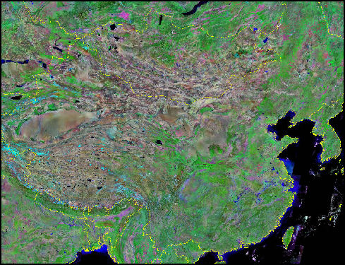
Satellite image of China
As a result of natural barriers, “the people of ancient China grew up in a world where their own culture not only dominated the cultures of surrounding peoples, but seemed to be virtually the only culture in existence. Although the nomad peoples to the north and west possessed sophisticated social and political patterns well suited to their economic needs, their living style did not appear to the Chinese as possessing any of the features which they had come to associate with civilization: agricultural settlement, urban centers of market, political, and religious activity, and literacy. The diverse peoples who lived in scattered settlements towards the east coast and in the forests of the south appeared even less advanced than the nomads. The Chinese, with none of the comparative perspectives available to Mediterranean cultures, saw themselves as a divine anomaly – what force could have brought forth so unique and perfect a civilization other than Heaven itself?” /+/
It is important “to understand China’s remoteness from other centers of civilization. People in China did not know about Europe or its people. Although it is very possible that through a slow process of step-by-step communication, inventions, techniques, and ideas may have seeped back and forth between Europe and East Asia for thousands of years, no one in the ancient world was awareof this if it did occur. As far as mutual recognition was concerned, China and the Mediterranean civilizations could just as well have been on different planets. Although India, the third great center of ancient philosophy, was near China geographically (contemporary India and China share a common border), the wall of the Himalaya Mountains was for each civilization an edge of the world over which nothing could pass. On the whole, then, ancient China’s geographical location on the globe placed it in effective cultural isolation, without any awareness that more than one complex civilization, China itself, existed. /+/
Diversity Within China
Dr. Eno wrote: “But the Chinese did not exist in total cultural isolation. The heartland of China was surrounded by a variety of different peoples. Nomadic cultures based on sheep and cattle herding flourished on the grassy steppes to the North and to the West; hunter-gatherer and fishing cultures existed in the forests of the South and on the coasts of the East. But none of these societies was literate, and none had created stable and complex centers of settlement. The Chinese people had for thousands of years practiced agriculture, and their gradually expanding domain was well marked by extensive engineering projects: networks of walls, roads, and irrigation canals that connected permanent village settlements and populous urban centers. These physical networks reflected enduring political and cultural connections as well. /+/
By Confucius’s time, in the 5th century B.C., China was actually a composite ethnic and cultural entity in the process of long-term dynamic change. One important reason why Chinese civilization was able to outstrip its neighboring cultures by so great a distance was precisely the richness of its multi-ethnic structure, which included cultural contributions from a variety of sources. Although individuals during the period of Classical China tended to conceive and speak of China as a single civilization with a single history and a single destiny, we will discover important variety within that civilization, reflecting the fault lines of China’s cultural geography. /+/

Language Groups in China
China’s Sense That It Is a Special Place
Dr. Eno wrote: “When Confucius, China’s most influential thinker, was born in 551 B.C., China was the most vast and complex political entity on earth, in touch only with the simple and unsophisticated cultures surrounding it. Cut off from Europe by the deserts of Central Asia, from India by the Himalayas, from the rest of the world by ocean, and surrounded by small, mobile, non-literate cultural groups, China had no way of conceiving a world in which there might be many alternative paths of human improvement, organization, and fulfillment. [Source: Robert Eno, Indiana University /+/ ]
“This situation led the ancient Chinese to view themselves as uniquely advanced and valuable. Chinese viewed their civilization as self-evidently the product of some special cosmic grace, and they assumed that there was something special about the culture heroes who, according to history and legend, had created Chinese civilization. Chinese civilization seemed the acme of human development, and the future of China meant nothing less than the future of human kind. This viewpoint is sometimes referred to as China’s "sino-centric" point of view (sino- is a prefix meaning “China”), and it contrasts very strongly with the Mediterranean awareness of multiplicity and variety in social practices and cultural values. /+/
“All this might lead us to expect that China, during the time of Confucius, would have been a static and monolithic society. But another set of geographical facts had created a very different situation. While the people of China felt they were, in fact, a highly unified group, there existed within Chinese civilization itself great diversity, the product of centuries of cultural absorption. /+/
China Proper
Patricia Buckley Ebrey of the University of Washington wrote: “To understand Chinese history and civilization, it is helpful to divide China into two large zones, China Proper and Outer China. China Proper is the area--changing constantly over time--where Chinese culture was dominant. Chinese dynasties also sometimes had control of significant regions populated primarily by other ethnic groups, areas we can consider Outer China. The bulk of China Proper is less than 1000 meters above sea level. With fertile alluvial soil, adequate water, and moderate temperatures, this zone is well-suited to agriculture, a key feature of Chinese civilization from its earliest stages. [Source: Patricia Buckley Ebrey, University of Washington, depts.washington.edu/chinaciv /=]

“Two great rivers run through China Proper: the Yellow River in the north, and the Yangtze (or Yangzi ) River to the south. In fact, most of China Proper belongs to the drainage-basins of these two rivers. Both originate to the far west in the Tibetan Plateau. The much smaller Xi River cuts through southern China.” Over time the courses of these rivers — particularly the Yellow River — have been many changes.” Sometimes the Yellow River has emptied south of the Shandong peninsula, rather than north of it as it does today. And for long periods, the Huai River emptied into the sea./=\
“China Proper was separated from the vast territories of Outer China to the north by the Great Wall. North China is dominated by the alluvial plain along the Yellow River (shown on the right). This part of China Proper is mostly flat and the soil, replenished by silt carried down by the river, is well-suited to agriculture. Staple crops of North China include wheat, corn, sorghum (a grass crop related to sugar-cane), millet and soybeans. Recently, thanks to new varieties and methods, rice has become more and more widely grown. /=\
“The region drained by the Yangtze (Yangzi) River, loosely called South China, is hillier than North China. The region is also warmer and more humid. Rivers are an integral part of the daily life of people in South China.” The Grand Canal was an important link between North China and South China. “From north to south, the Grand Canal is over 1,700 kilometers (roughly 1,100 miles) long, linking Hangzhou in Zhejiang province with Beijing in the north. First started in the Sui dynasty (589-618), it connects several big rivers and provides an important means of transportation and communication. Although provinces such as Guangxi, much further west, are generally more mountainous, they still usually have navigable rivers. Tea is widely grown in the hilly regions in South China and many parts of West China, such as Sichuan province. In fact, tea is so popular in China that it is considered a basic necessity of life. /=\
Outer China
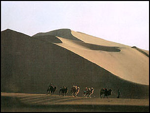
Sand dunes in Xinjiang
Patricia Buckley Ebrey of the University of Washington wrote: “Outer China is the huge area to the north and west of China Proper. It ranges from 1,000 to 5,000 meters above sea level. The zone includes part of Northeast China (also known as Manchuria), Xinjiang, Inner Mongolia, the Yunnan-Guizhou Plateau, part of the Loess Plateau, and a stretch of mountains. [Source: Patricia Buckley Ebrey, University of Washington, depts.washington.edu/chinaciv /=]
“North of China Proper, the Inner Mongolian Plateau is a combination of prairie, mountain, and desert, much of it suitable for raising sheep. Northwestern China has extremely dry weather, which is good for growing such fruit as melons and grapes. The Yunnan-Guizhou Plateau is in the southwest./=\
“The Tibetan Plateau in Southwest China occupies about one-fourth of the land area of the PRC. It is composed of high and super-high mountains and massive highlands, averaging between 4,000 and 5,000 meters (13,000 to 15,000 feet) above the sea level. People on the Tibetan Plateau live mostly in the river valleys. In the summer, herders move their tents to new pastures. The highest point along the Tibetan Plateau, Mount Everest (known in Chinese as Mount Zhumulangma) is also the highest mountain in the world. It is located on the Sino-Nepalese border and rises 8,848 meters (29,028 feet) above sea level.” /=\
Chinese Heartland
Dr. Robert Eno of Indiana University wrote: “Much of this territory reflects the fact that China was constructed as an empire. Its heartland, anchored in its eastern provinces and populated by an ethnic majority known as the “Han” (meaning the descendants of the great Han Dynasty, which flourished about 200 B.C. to 200 A.D.), was expanded through conquest and settlement in order to create vast buffer regions, protecting the central state from marauding neighbors. [Source: Robert Eno, Indiana University /+/ ]
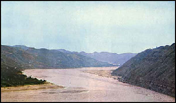
Yellow River, home of some
of the world's earliest civilizations “Today, this variety is both a source of cultural richness and of considerable political tension within China. In the past, sustaining China’s empire often entailed great expense of treasury and life in defense of far-flung borders. And despite these efforts, at certain periods China was conquered and brought under the political control of non-Chinese peoples whose origins lay beyond the bounds of the empire. /+/
“The traditional heartland of China – from Liaoning Province to Guangdong Province on the east coast, stretching west to Shaanxi, Sichuan, and Guangxi Provinces to the west, can be easily divided into two great river valley regions: the Yellow River valley region in the north, and the Yangzi River valley region in the south (see Map 2). The highlands of the Qinling Mountains stretch east from Tibet towards the Pacific, dividing these two regions, and the Chinese often think of their mainstream culture as possessing two variants, Northern and Southern, characterized by major economic, social, and linguistic differences. /+/
China’s Great Rivers: the Yangtze and Yellow River
Dr. Eno wrote: “Within its relatively secure boundaries, China’s geography was diverse. The territory of ancient China was dominated by two great river valleys. In the north, where Chinese civilization seems first to have developed, there flowed the Yellow River. The character of the Yellow River basin was the product of the Central Asian deserts far to the west. Over many millennia, western winds blew the sands of these deserts over the upper and middle reaches of the Yellow River valley. These deposits, called “loess” gradually rose into high plateaus, fertile, but easily eroded into a landscape of steep escarpments. The river itself carried the sandy soil of these areas towards the east, taking on a muddy color which the Chinese classed as “yellow.” As the Yellow River flowed east, the silt it carried gradually raised it out of its original banks. Consequently, it flowed over the North China Plain as a broad shallow band, ideal for irrigation and fertilization of the neighboring crop land, but subject to disastrous flooding. The river actually has no natural bed as it crosses the North China Plain, and has more than once shifted course so radically that its mouth has been moved hundreds of miles. [Source: Robert Eno, Indiana University indiana.edu /+/ ]
“ 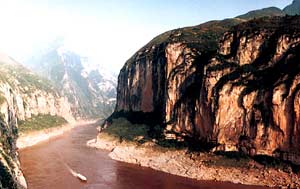
Yangtze River To the south, separated from the Yellow River by the steep Qinling Mountains, lay the valley of the Yangzi River. The Yangzi was far friendlier than the Yellow River. It was deeper, thus more navigable, and it was fed by numberless smaller rivers and streams which could facilitate irrigation and transportation. Ultimately the center of Chinese civilization would shift towards the mouth of the Yangzi, where cities like Nanjing and Shanghai now stand. But in ancient China these lands were still sparsely inhabited, although some major cultural centers developed there after the middle of the first millennium B.C. /+/
“Between the colder, dryer basin of the Yellow River and the warm, humid Yangzi Valley were a number of other important river valleys along which settlements of Chinese culture flourished. These included most prominently the Huai and Han Rivers, and also the smaller River Luo, which joined the Yellow River near the North China Plain, as well as the Wei River, just at the Yellow River’s great elbow bend to the north. /+/
“The earliest centers of Chinese culture had developed during the period c. 5000 - 1000 B.C. in the basin of the Yellow River in the North, an area of dry but fertile soil and moderate rainfall, ideal for raising dry grain crops that were close relatives of wheat and barley. Over time, and particularly after about 1000 B.C., the political and military strength of Chinese culture led to a gradual expansion of its influence into the Yangzi River basin in the South and towards the Southeast coast, an area of high rainfall, rivers and lakes, ideally suited for the cultivation of wet-grain varieties of rice. In these southern regions, the advancing culture of the North China Plain encountered a variety of local cultures with very different features, which, through military, political, or economic processes, were gradually absorbed into Chinese culture as a whole.” /+/
North China
Dr. Eno wrote: “It was in North China that the earliest civilizations ancestral to modern China first appeared. Northern China is largely a dry region, over which westerly winds carries desert sand from the dry Tarim Basin and Gobi Desert to the east, depositing it over much of North Central China. This airborne silt, called “loess” , forms a thick layer of topsoil, fertile but easily eroded. It stretches east across the great bend in the Yellow River, on past the limits of the central mountains, and across the broad valley of the lower Yellow River, known as the North China Plain. [Source: Robert Eno, Indiana University/+/ ]
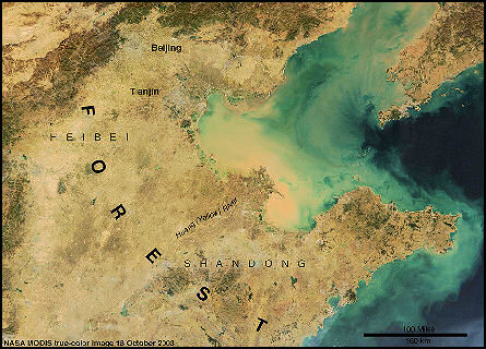
Satellite image of the crop plain of northeast
This plain, sometimes called the cradle of Chinese civilization, has historically been densely populated farm country, sustained by dry-grain agriculture based on millet, wheat, and sorghum, supplemented by vegetable crops. Because of low rainfall, the Yellow River has served as a critical source of field irrigation, but at a great price. The river carries enormous amounts of loess soil in the muddy water that gives it its name; this fertile silt gives the plain its rich farming land. However, the river bed is constantly rising as the silt is deposited, so that the river is actually higher than the surrounding land. Over the millennia, the Chinese have contained its waters by means of massive dikes, but periodically, these have failed, resulting in catastrophic floods. The river, which now empties into Bohai Bay, north of the Shandong Peninsula, has in the past changed its course to empty into the ocean south of Shandong, returning centuries later to its older path. These shifts have had devastating effects on the people of North China. /+/
“For thousands of years, the center of gravity of Chinese culture was in the North, the South being sparsely populated jungle. The early capitals of China were located close to the Yellow River or its tributaries. Although in the earliest periods of Chinese history, the climate was warmer and wetter than it is now, the North was never a region of easy abundance, and Northern culture has traditionally been cautious and conservative. /+/
South China
Dr. Eno wrote: “The Yangzi River valley region was home to some important contributors to early Chinese civilization, but it lay beyond the borders of the earliest Chinese homelands, and Chinese migration to the South did not begin on a large scale until the first century AD, after farmers in the North China plain suffered a particularly disastrous series of floods. [Source: Robert Eno, Indiana University /+/ ]
“South China is warm and moist, a land of rivers and lakes. Once refugee farmers cleared the land, crops were far easier to grow than in the North. The most widely grown grain is rice, which is grown in flooded fields called paddies. Rice farming requires the leveling of fields, so that water can be held within raised field borders, and intensive labor to nurture, transplant, and maintain rice sprouts. But the weather allows the harvesting of two to three crops a year, making rice farming much more productive than dry grains. In addition, the Southern climate is ideal for cultivating fruits, nuts, and vegetables. Moreover, the abundance of waterways, allowing for easy transport, makes South China far more conducive to communications and the movement of goods. This combination of agricultural promise and transportation ease resulted in Southern Chinese culture laying much greater stress on trade and commercial development than was true of the North. From about 1000 AD on, these greater economic opportunities drew the balance of the Chinese population South, and from the 12th to the 17th centuries, the capitals of China were usually located there. A burgeoning urban culture led to a generally more dynamic and daring society than was the case in the North. /+/
“Whether in the North or South, Chinese society has always been based on agriculture. From earliest times, in a world context, China has been a heavily populated society, reliant on high crop yields to sustain itself. Although China is a large country, and was even in ancient times, before its imperial ambitions expanded its borders, in fact only a small percent of its land is suitable for agriculture. In many areas, steep hills, high mountains, swamplands, and deserts make farming impossible. Although in total size China is comparable to the U.S., China has only half as much arable (farmable) land. The struggle to use limited land to nurture a large population has been a theme since the earliest stages of Chinese history. /+/
History and Population in China
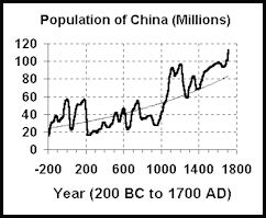 At the time of Christ four fifths of the world's population lived under the Roman, Chinese Han and Indian Gupta empires. The world population at that time was estimated to be 225 million, compared to around 87 million in 4000 B.C.
According to Chinese records, between A.D. 2 to A.D. 742 the population of China remained steady at around 50 million. The population fluctuated in different areas, however. The population of the Yellow River Plain decreased from 35 million in A.D. 2 to 25 million in A.D. 140, rose to 31 million in 609 and fell again to 23 million in 742. During Han Dynasty (206 B.C.- A.D. 220) the highest population densities were on the Yellow River in present-day Shanxi and Henan provinces.
Population growth in China has been linked to increased crop yields achieved through innovations, improvements in agricultural techniques and intensification. During the Tang Dynasty (618 to 907) increases in rice production though intensive irrigation resulted in a doubling of the Chinese population, mainly around Yangtze river. Another period or rapid population growth took place during the Song Dynasty (A.D. 960-1127) green revolution. The population began to rise again after 1450 with the introduction or new rice varieties, sweet potatoes and corn.
History, Hunger, Disease and Famine in China
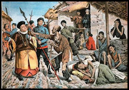
Famine in 1907
Chinese history has been shaped very much by food supply, hunger and famine. Historians have shown that peasant uprisings and revolutions have tended to occur during times of high food prices and large population increases while periods of stability have tended to occur when there was enough food to feed everybody.
During the Tang dynasty (618 to 907) arts and ideas flourished when record rice harvests were being recorded, but the entire dynasty began to collapse when the rising population began to outstrip the food supply. An Arab traveler to China at end of the Tang dynasty wrote that “Chinese law permits the eating of human flesh, and this flesh is sold publically in markets" as a means of providing enough food
In the 11th and 12th centuries, China imported rice from Vietnamese but still suffered from food shortages.
In the 14th century a series of epidemics and famines killed an estimated 35 million people — one in three Chinese. It is estimated that six million died of starvation during the Great Famine of 1333 and 1337.
A three year drought from 1876 to 1879 in central China resulted in a famine that affected 70 million Chinese and left perhaps nine million dead. According to some reports people turned to slavery, murder and cannibalism to survive and children were sold in the markets as food. There were so many bodies that huge graves, known as "10,000-man holes," were dug. Because of the secretive nature of the Manchu dynasty no one in West knew of the disaster until a year after it was over.
Three million starved to death during the devastating drought in the provinces of Hunan, Gansu and Shaanxi in 1928 and 1929. There was also hunger and starvation under Mao during the Great Leap Forward and the Cultural Revolution. The two greatest famines in the 20th century were in China in the 1960s and the Ukraine in the 1930s.
Migration patterns were also defined by the food supply. The population of Hunan increased fivefold between the 8th and 11th century with mass migrations of Han Chinese and the establishment of the region as one of the granaries of China.
See Separate Article FAMINES IN CHINA factsanddetails.com
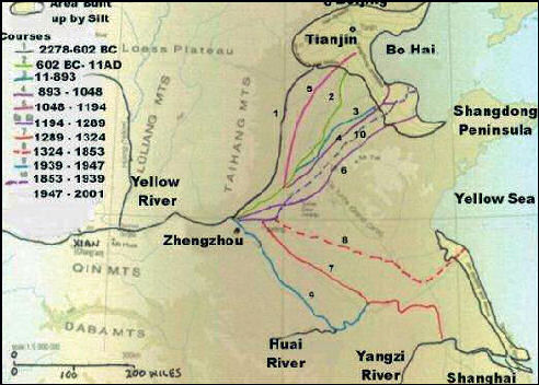
Flood-induced course changes on the Yellow River
Floods and Earthquakes in China
Chinese history has also been shaped by natural disasters Some of the worst floods and earthquakes occurred in China. According to the Guinness Book of Records, the deadliest earthquake ever killed 830,000 people in Shaanxi, Shanxi and Henan Provinces in 1556. Six of the 13 deadliest earthquakes ever occurred in China.
The worst recorded earthquakes (number of dead): 1) Shaanxi, China, Jan. 24, 1556 (830,000); 2) Calcutta, India, Oct. 11, 1737 (300,000); 3) Tangshan, China, July 28, 1976 (242,000); 4) December 26, 2004, Sumatra, Thailand and Sri Lanka (225,000); 5) Antioch, Syria, May 20, 526 (250,000); 6) Yokohama, Japan, Sept. 1, 1923 (200,000); 7) Nan-Shan, China, May 22, 1927 (200,000); 8) Hokkaido, Japan, Dec. 30, 1730; 9) Chihli, China, Sept. 27, 1290 (100,000); 10) Gansu, China, Dec. 16, 1920 (200,000); 11) Messina, Italy, Dec. 28, 1908 (83,000); 12) Shemaka, Caucasia, Nov. 1667 (80,000); 13) Gansu, China, Dec. 26, 1932 (70,000). [Source: The World Almanac]
The five worst floods in history, based on the number of people dead, all occurred in China: Worst Recorded Floods: (number of dead): 1) Yangtze River, China, August 1931 (500,000–4,000,00); 2) Huang He (Yellow River), China, 1887 (900,000–2,000,000); 3) 1938 Yellow River flood (500,000–800,000), 1939; 4) Banqiao Dam failure and floods, 1975, (229,000) 1975; 5) 1935 Yangtze flood(145,000), 1935. ) Holland, 1228 (100,000); 7) Indonesia, Aug 27, 1883 (100,000); 8) Morvi, India, Aug, 11, 1979 (15,000); 9) Bangladesh, Oct 10, 1960 (6,000); 10) Galveston, TX, Sept. 8, 1900 (5,000). [Source: Wikipedia for China; World Almanac for the others]
According to the Guinness Book of Records, the deadliest flood ever killed 900,000 people around the Yellow River in October 1887. A flood in China in 1642 is estimated to have killed 300,000 people.
See Separate Article CHINA: HOME OF THE WORLD'S FIVE MOST DEADLY AND DESTRUCTIVE FLOODS factsanddetails.com
Image Sources: Wikimedia Commons
Text Sources: Robert Eno, Indiana University /+/ ; Asia for Educators, Columbia University afe.easia.columbia.edu; University of Washington’s Visual Sourcebook of Chinese Civilization, depts.washington.edu/chinaciv /=\; National Palace Museum, Taipei \=/; Library of Congress; New York Times; Washington Post; Los Angeles Times; China National Tourist Office (CNTO); Xinhua; China.org; China Daily; National Geographic; The New Yorker; Time; Newsweek; Reuters; Associated Press; Lonely Planet Guides; Smithsonian magazine; AFP; Wikipedia; BBC. Many sources are cited at the end of the facts for which they are used.
Last updated August 2021
