XINING
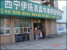
halal butcher in Xining Xining (160 kilometers west-northwest of Lanzhou) is the capital and largest city of Qinghai Province , with about 1.5 million people. A once desolate frontier town and the last major town before Lhasa, it is populated by a mix of Muslims, Chinese and Tibetans. The train to Xining climbs to an elevation of 2,440 meters (8,000) feet on its way to the Tibetan plateau, passing cliffs with troglodyte caves with dizzying stairways. During the hot summer months, many tourists from the hot Southern and Eastern parts of China travel to Xining, as the climate of Xining in July and August is quite mild and comfortable, making the city an ideal summer retreat. The city has a big, modern train station to accommodate them and serve as gateway for the train to Tibet.
Qinghai Province Museum (Xining Square in Chengxi District) covers an area of 22,800 square meters and has nine exhibition halls with a total area of 9,146 square meters. The three main exhibition sections are: 1) the Exhibition of Pre-History Civilization in Qinghai, 2) the Exhibition of Ethnic Cultural Heritage in Qinghai, and 3) the Exhibition of Buddhist Art.
Tibetan Medicine Museum of China (36 Jing’erlu Road in the Bioscience Park) is the first Tibetan medicine museum in the world and the only museum exclusively devoted to Tibetan medicine museum in the world. Its functions are to protect, do research on and serve as a showcase of Tibetan medicine, Ti betan folk customs and Tibetan Buddhism. “The Panorama of Tibetan Colored Paintings,” which is reputed as an encyclopedic drawing of Tibetan, culture and arts, is the most valuable exhibit in the museum. It took Tangka painting master Zongzhe Lajie 27years to conceive the work and more than 400 leading Tibetan, Mongolian, Han and Tu artists from Tibet, Gansu, Sichuan and Yunnan four years to finish it.
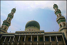
Dongguan Grand Mosque (south side of Dongguan Street) is the largest mosque in Qinghai and one of the largest in northwest China, covering an area of 11,940 square meters (1.194 hectares). Founded in 1380, it is the best-preserved ancient building in the city. The style of the mosque combines both traditional Chinese design and Islamic architectural features, with grand appearance and delicate, dazzlingly inside ornaments interior appointments. Its prayer hall can hold up to 3,000 people. the mosque is not only well known for its magnificent architecture but also for its role as a religious education center and an Islamic institute of higher learning. When Islam’s important holidays come around, tens of thousands of worshippers come to participate in ceremonies and religious activities; Admission: 25 yuan (US$3.92) per person;
Tourist Office: Qinghai Provincial Tourism Bureau, 21 Huaghe Rd. 810001, Xining, Qinghai China, tel. (0)- 971-900-6020, fax: (0)- 971-823-9515 Web Sites: Travel China Guide Travel China Guide Maps of Xining: chinamaps.org ; Budget Accommodation: Check Lonely Planet books; Getting There: Xining is accessible by air and bus on is on the train line between Langzhou and Golmud. Lanzhou is two to two and half hours away by fast train. Travel China Guide Travel China Guide Lonely Planet Lonely Planet
See Separate Article: QINGHAI PROVINCE: VAST HIGH ALTITUDE GRASSLANDS, TIBETAN TOWNS AND THE SOURCES OF YELLOW AND YANGTZE RIVERS factsanddetails.com
Near Xining
Dongguan mosque in Xining Mengda Nature Reserve (110 kilometers southeast of Xining in the Xunhua Salar Autonomous County) is an area of natural beauty with a surprisingly green and wet environment, earning it the nickname “highland Xishuangbanna.” (Xishuangbanna is a fairyland inis the tropical southern region in China’s Yunnan Province). Established in 1980, the reserve is the first reserve focusing on plant protection in Qinghai. Covering a total area of 9,544 hectares, it features primeval primeval forest, a large variety of exotic flowers, waterfalls and many wild animals. Mengda Heavenly Lake has been described as a pearl on the Tibetan Plateau. It is a perfect place for hiking and boating; Admission: 70 yuan (US$10.99) per person;
Kanbula National Forest Park (in Huangnan Tibetan Autonomous Prefecture, 131 kilometers from Xining) features specular rock formations like those found in Arizona and Utah. Covering an area of 152 square kilometers, the park is famous for its unique red gravel rock landforms, forests, soaring peaks, crystal clear water and Tibetan culture. With an altitude of 2,100 to 4,000 meters above sea level, it borders on the Yellow River in the north and is close to Lijiaxia Hydropower Station. The weather amid the mountains can change very frequently; Admission: 87 yuan (US$13.66) per person; Visitors can stay in beach ball-colored cabins called space capsules for US$14 a night.
Taer Lamasery
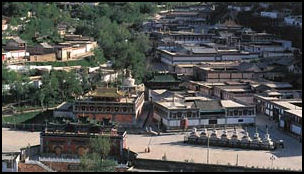
Taer Lamasery (in Lusha’er Town, Huangzhong County, 25 kilometers southwest of Xining) is one of the six largest Tibetan Buddhist monasteries of the Gelugpa (Yellow Hat) Sect of Tibetan Buddhism and one of the largest lamaseries outside Tibet. Covering over 40 hectares (100 acres), it contains 35 buildings and temples filled with Han Chinese and Tibetan art. Butter sculptures, mural paintings and embroidery are three spectaculars specialties of the Ta'er Lamasery. One erotic sculpture shows a woman having sex with an ox.
Taer Monastery
Inside the monastery halls, monks beat on drums while chanting in shrieking voice in rooms filled with smoke from yak butter lamps and incense burners with cypress leaves. Stuffed yaks, goats and bears are placed around the temple and offerings are pinned to them. The huge kitchen smells like a tannery. Meals there are sometimes cooked in seven-foot vats capable cooking 13 yaks at one time.
Taer Monastery is located at the site of the former home and birthplace of Zongkaba (1357-1419), the founder of the Gelugpa Sect, who taught here before moving onto Ganden monastery near Lhasa. While in Lhasa, Zong's mother wrote him and asked him to return, Zong wrote back he couldn't make it. At that instance, the story goes, a pipal tree miraculously sprang up at his birthplace, the same way a Bodhi tree arose when Buddha received the enlightenment. The monastery was built around the pipal tree in 1560.
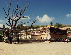
Taer Monastery is also known as Kumbum or Kumbun Monastery. Among the other miracles that have occurred there over the years have been the sudden appearance of trees at the Flower Temple and strange inscriptions that have been mysteriously carved into in their trunks. On display in one of the temples is the white horse that dropped dead after bearing the 9th Panchen Lama here in 1903.
Founded in 1379, the lamasery sits on the slopes of a mountain and embraces 9,300 structures, including scripture halls, Buddha halls, lamas' residences, and Buddhist pagodas. The monastery is very busy. Pilgrims arrive in great numbers and young boys study to be monks. In 1749, Emperor Qianlong of the Qing Dynasty (1644–1911) bestowed on the temple a horizontal board to be placed above its main gate, on which the emperor wrote the words, “Fanzong Temple”. Renovations have been done with money donated from Taiwan, South Korea and Hong Kong as well as Beijing. Admission: 80 yuan (US$12.56) per person;
Monks at Taer Lamasery
Kumbum monastery
(Taer monastery) The present Dalai-Lama was born in the hills nearby Taer and the 3rd Dalai Lama is buried in the monastery's Nine-Roomed Hall. Before the period of Chinese repression, 3,600 monks lived here. During the Cultural Revolution there were virtually none. By the mid-1980s, the number of monks had increased to 500 again.
Taer Monastery is regarded as the most Beijing-friendly Tibetan monastery. It was in the 2000s restored as part of a four-year, US$5 million project paid for by Beijing because the main lama who resided there was deemed to be cooperative (the lama ended up escaping to India and then California in 1998). Former President Jiang Zemin visited the monastery.
Sometimes there is a heavy police presence at the monastery and lamas have been paraded in front of the foreign press to tell reporters they have religious freedom. More than 600 monks have been put through three-month re-education classes and have been forced to disavow Tibetan independence and the Dalai Lama.
The monks have been at the center of the controversy over support of the Beijing-selected Panchen Lama versus the Dalai-Lama-selected Panchen Lam (they have publicly said they supported the Beijing-selected one but privately said they supported the Dalai-Lama-selected one). Portraits of the Dalai Lama are visible.
Taktser, Birthplace of the Dalai Lama
Taktser (an hour by car from Xining) is where the present and 14th Dalai Lama was born on July 6, 1935 in a mud and stone hut when the village had 20 families. Known in Chinese as Hongyacun, it is situated in a remote and desolate region in western China formally known as Amdo region. The village is comprised of households clustered on a red-rock hill that villagers say resembles a crouching lion. The Dalai Lama's parents gave him the name Lhamo Dondrup (which means "Wish-fulfilling Goddess"). In his autobiography the Dalai Lama wrote: “my family was one of twenty or so making a living from the land there."
The Dalai Lama — whose birth name was Lhamo Dondrup — was the ninth child and second son of peasant-farmers, Choekyong and Dekyi Tsering. He was born on the floor of a cow shed on his family's farm. As a child he dressed in traditional Tibetan clothes and he spent the early years of his life in a square mud walled house without windows. His parents met for the first time at their wedding ceremony. They had 16 children but only seven survived past infancy.
In Tibetan Taktser means "Roaring Tiger." Today Taktser is made up of 250 or so households clustered on a red-rock hill. Evan Osnos wrote in The New Yorker, “Neighbors pointed us to the nicest home in the village, a courtyard was later rebuilt, and is now maintained by a relative of the Dalai Lama’s. The authorities keep him close; according to the state news agency, he receives a salary from the government and serves on a local political advisory body.An old woman with silver teeth and a pair of braids opened the wooden doors. The courtyard was lined with cobblestones and flanked by flower beds; prayer flags fluttered overhead. When she saw me, she said, “Sorry, they've told us foreigners aren't allowed inside. If we let them, there will be problems for us."
Qinghai Lake
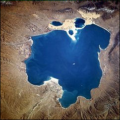
Koko Nor Qinghai Lake (160 kilometers west of Xining) Qinghai Lake is the largest lake in China and ome the largest salt lakes in the world. Located in northeastern Tibetan Plateau at 3,260 meters (10,700) above sea level, it is surrounded by four continuous mountains and broad grasslands. The lake has an abundant supply of fish, which in turn attracts large flocks of birds living in nearby wetlands, while yaks and sheep graze on the lakeside grassland.
In English, Qinghai Lake was formerly known as Ch'inghai Lake or Koko Nor. Koko Nor means "Sky Blue Sea" in Mongolian. Qinghai is means blue or green in Chinese. China's first atomic bombs were prepared at a site on the northeastern shore of the lake in 1964. Salt and potash was mined from the central plain around the lake. A naval torpedo testing station operated until the 1980s, when water levels dropped too low. For a while the station was a museum but now it is abandoned more than 100 meters from the shore.
Qinghai Province is named after Qinghai Lake. The lake has an area of about 4,500 square kilometers and a circumference of over 360 kilometers. Making it the 34th largest lake in the world.. The average depth is 20 meters. The lake, as its names imply, has lovely blue water that is sometimes misty and other times wavy. Around the lake are picturesque grasslands and fields with wheat and rapeseed as well grazing areas for countless sheep, cattle and horses.
Qinghai Lake was nominated to be a UNESCO World Heritage site in 2017. According to a report submitted to UNESCO: The area of nominated property is 4952 square kilometers, located at the northeastern corner of Tibetan-Qinghaian Plateau, in the eastern part of Qinghai Province. As a closed inland basin surrounded by mountains, the region is adjacent to Datong Mountain on the north, Riyue Mountain on the east, Qinghai Nanshan Mountain on the south and Xiangpi Mountain on the west. The nominated property is located completely inside Qinghai Lake National Park, while the boundary of the nominated property coincides with that of Qinghai Lake National Nature Reserve” in “Gonghe County in Hainan Prefecture, Haiyan and Gangcha Counties in Haibei Prefecture.” [Source: National Commission of the People's Republic of China]
Getting There: The north side is accessible by train. You got a long view of the lake from the train that goes to Tibet. But unfortunately most of the bird life is on the southern side. Most people get there as part of an organized tour or rent a vehicle and driver.
Travel China Guide Travel China Guide Budget Accommodation: Check Lonely Planet books; Admission: 270 yuan (US$42.38) per person;
Fluctuating and Salty Qinghai Lake
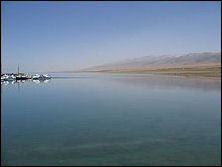
Qinghai is a salt lake. Salt lakes have significantly larger amounts of salt and other minerals than freshwater lakes. Some of them even have a higher concentration of salt than sea water. When water evaporates from the lake, the salt is left behind, making salt lakes a great place for salt production. If the amount of water that evaporates from the lake is more than the water flowing into it, salt deposits will gradually form and create unique sceneries.
Qinhai lake fluctuates in size, shrinking over much of the 20th century but increasing since 2004. It’s surface area in 2008 was 4,317 square kilometers (1,667 square miles). Seasonal fluctuations can reduce the lake by almost a third in the dry season. In 1965 the average size of the lake was 10,000 square kilometers. In the early 2000s it much less than that. In Between 1970 and 2000 the water level has dropped almost four meters and the number of rivers feeding the lake dropped by half, exposing an area the size of Singapore. Smaller lakes were breaking off from the larger lake and large sand dunes tower over the eastern edge of the lake.
According to a report submitted to UNESCO: Przewalksii's naked carp (Gymnocypris przewalskii) became the only fish left in this vast lake. This fish has developed a migratory breeding strategy because its egg could not grow in saltwater. Every summer, numerous Przewalksii's naked carp migrate from Qinghai Lake towards the upstream of the inflowing rivers, while the fish-eating waterbirds gather for food, forming an extraordinary and unique ecological phenomenon on the Tibetan-Qinghaian Plateau.” [Source: National Commission of the People's Republic of China]
The lake used to be full of fish and fisherman pulled in large catches of an unusual scaleless naked carp. But fish levels have dropped off catastrophically and all fishing ins now banned The terraces of salt that rise up from the shore indicate that the lake has been shrinking for a long time: the result of the shrinkage of some glaciers which help feed the lake as well as less rain and desertificition caused by overgrazing. The whole region is dotted by salt lakes, which are often completely evaporated and look like basins of freshly fallen snow.
Sights in Qinghai Lake
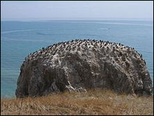
Bird Island Qinghai Lake attracts many tourists. May, June, and July are the best months to visit weatherwise. The area surrounding the lake is populated by ethnic Tibetans. Most pre-arranged tours stop at Bird Island. An international bicycle race takes place annually from Xining to Qinghai Lake.
Being a highland lake with unique characteristics, Qinghai Lake attracts tourists with its natural landscapes, wetland scenery, nomadic culture, Tibetan religious sites and China Atom City. Various tourist attractions and activities showcase the plateau culture and ethnic customs, such as ethnic songs and dances, sand beaches by the lake, a Tibetan folklore garden, a herdsmen’s home, a boat tour of the lake, and the ceremony for offering sacrifices to the lake. You can ride horses, camels, yaks, horse-drawn cart and Suvs.
Bird Island (360 kilometers from Xining) is a 800,000-square-meter piece of land that is more often a peninsula than an island. Over 100,000 birds of different species can be found here at certain times of the year pecking through the muck looking for worms and things. It is now an island in name only because the water has dried up around it. This has put crimps on the birdwatching activities and tourism. Bird Island is a sanctuary for many kinds of birds and is regarded as one of China's eight key bird nature reserves. Covering an area of 0.11 square kilometers, the island provides habitats for over 100,000 migrating birds from south China and Southeast Asia. The high densities of birds found here is rare.
Nongbaotan Nature Reverse (Yushu Tibetan Autonomous Prefecture in Qinghai Province) was established to protect a major breeding ground for black-necked cranes. Embracing spectacular lakes and wetlands, the reserve is 30 kilometers long and four kilometers wide. The grand Bayankela Mountains form a backdrop in the distance.
Geology and Topography of Qinghai Lake
According to a report submitted to UNESCO: Lake Qinghai “is located in the northeast part of the Tibetan-Qinghaian Plateau. It is the largest lake on the largest, highest and youngest plateau in the world, as well as the largest lake in China. Here numerous rivers run through the vast expanse of grassland featuring rich water resource, lush vegetation and quiet environment. The lake is surrounded by four towering mountains, all reaching 3600 meters to 5000 meters altitude: Datong Mountain on the north, Riyue Mountain on the east, Qinghai Nanshan Mountain on the south and Xiangpi Mountain on the west-the four natural barriers embrace the Qinghai Lake. Between the foot of the mountains and the lakefront lies a vast and flat grassland, while the misty waves and endless blue of Qinghai Lake remind of a huge jade plate embedded between the mountains and grasslands. The mountains, the lake and the grassland constitute a scenic, extraordinary landscape. [Source: National Commission of the People's Republic of China]
“The water of Qinghai Lake used to flow into the Yellow River water system. 210,000 years ago, Qinghai Lake became endorheic due to the uplift of the Tibetan-Qinghaian Plateau. Meanwhile, the salinity of the water increased, and the ecosystem and ecological process changed as Qinghai Lake turned from a freshwater lake to a saline lake. Qinghai lake lies in the southern edge of Qilian orogenic belt, between the southern Qilian geosyncline and the Nanshan geosyncline in Qinghai. It is a rift basin generated by the late Himalaya neotectonic movement, mainly under the influence of three fracture structures in NWW, NNW and near SN directions. The major part of the nominated property, the Qinghai Lake, was formed about 210,000 years ago to be a neotectonic rift lake, which in even earlier ages, 200,000,000 years ago, was part of the Tethys Ocean.
“During the early stage of lake formation, Qinghai Lake was an exorheic freshwater lake connected with the ancient Yellow River. Later on, as the Qinghai Lake region experienced an uplift due to the drastic uplift of Tibetan-Qinghaian Plateau during the Quaternary Period, the rising Riyue Mountain blocked the drainage of Daotang River to Yellow River, and Daotang River drained westward into Qinghai Lake instead. Meanwhile, the mineral sediment at the bottom of the lake was continuously eroded and dissolved into the water, further increasing the salinity to form a saline lake. As a crucial part of the Tibetan-Qinghaian Plateau, the geological evolution of the rift basin, Qinghai Lake, somehow recorded the geological history of the tectonic movements of the whole Tibetan-Qinghaian Plateau.
“The general topography of the nominated property inclines from west to southeast, with the mean altitude of 3848 meters. The highest point is Kanggarxolug in the western Datong Mountain on the north of the lake, with the altitude 5291 meters. The lowest point is the surface of Qinghai Lake, with the altitude 3193.3 meters. The highly diverse geomorphic types in the region mainly include lakeside plains, alluvial plains, low mountains, mid-mountains, high mountains, ice plateaus and contemporary glaciers. In the northern and eastern parts of the region, massive aeolian accumulation has led to the development of sandy land, mobile dunes, semi-fixed dunes and fixed dunes. Swamps are distributed in the low-lying land beside the lake. In the western and northern parts of the lake develop river floodplains, deltas and river accumulation terraces. By the riverside distribute sand bar terrace. In the area where foothills alternate with plains there are alluvial fans, and the landscape is dominated by the lake, lakeside and mountains.”
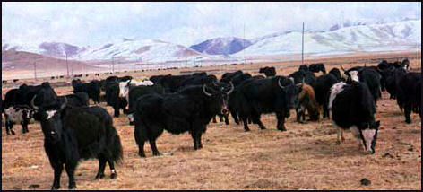
Yaks and yak-cow hybrids
Ecosystem and Wildlife of Qinghai Lake
According to a report submitted to UNESCO: The Qinghai Lake is an inland saline wetland of international importance. It is the largest inland saline lake watershed, the huge water body and the surrounding water system has given birth to the vast and unique plateau inland wetland ecosystem, providing ideal habitat for many wild animals. Qinghai Lake is also an important water body for the ecological safety of the northeastern Tibetan-Qinghaian Plateau, a natural barrier to prevent the eastward expansion of the desertification in western China, a treasury of the richest biodiversity on the Tibetan-Qinghaian Plateau, a concentrated habitat and breeding ground of waterbirds, and the only habitat of an endangered animal, Przewalski's gazelle (Procapra przewalskii). Qinghai Lake plays an irreplaceable role in enriching the biodiversity of Tibetan-Qinghaian Plateau, adjusting the climate of northwestern China, preserving water source and maintaining ecological balance. The ecological environment of Qinghai Lake and its pattern of evolution reflect the trend of the overall ecosystem of the Tibetan-Qinghaian Plateau. Qinghai Lake has become a precious study site for bird migration pattern, and for plateau food chain, ecological environment and biodiversity, providing an important gene pool for plateau organisms with great value for scientific research. [Source: National Commission of the People's Republic of China]
“Qinghai Lake is located at the crossroads of the Central Asian and East Asian Flyways. As an important stopover for migratory birds, each year hundreds of thousands of birds rest in this area during their migration. Qinghai Lake is also the breeding ground for the largest number and the most concentrated population of summer migrants. Each year the large waterbirds brown headed gulls (Larus brunnicephalus), Pallas's gulls (Ichthyaetus ichthyaetus), bar-headed geese (Anser indicus), great cormorants (Phalacrocorax carbo) that gather here to breed add up to more than 58,000 individuals. Besides, the mountains around Qinghai Lake belong to the Important Bird Areas, where live a large number of birds endemic to the Tibetan-Qinghaian Plateau or to China, such as the Tibetan rosefinch (Carpodacus roborowskii), the Sinai rosefinch (Carpodacus synoicus), and the Przewalski's finch (Urocynchramus pylzowi).
“The Przewalski's gazelle that only lives around Qinghai Lake is the rarest mammal species endemic to China, and also one of the rarest ungulates in the world, listed as “endangered” (EN) species by IUCN, Category I wildlife species in China, and “critically endangered” species by China Red Data Book of Endangered Animals: Mammalia published in 1999. The Qinghai Lake National Nature Reserve Administration has taken various measures to save the Przewalski's gazelle. As a result of many years’ protection effort, the number of Przewalski's gazelle individuals has increased from 300 plus in the 1990s to more than a thousand, the number of populations from 7 to 11, and the protection status turned from “critically endangered” (CR) to “endangered” (EN).
“Over the years, the Reserve Administration has paid great effort in conservation, scientific research, eco-tourism and community co-management, accomplishing significant achievements. First, through increasing the law enforcement and applying both on-board and on-land patrols, the conservation and management of the wildlife has improved, especially for the rare and endangered animal Przewalksii's gazelle, Category I protected species black-necked crane, Category II protected species whooper swan (Cygnus cygnus) and Przewalksii's naked carp. Second, the influence of the Nature Reserve has expanded, the investment has increased to strengthen scientific research and conservation, as well as the monitoring of the fragile plateau lake wetland ecosystem of Qinghai Lake and surrounding wetlands, facilitating the sustainable development of the reserve. Now the reserve has become a basement for scientific research and education, and a major advertisement for Qinghao Province.”
Atomic City: China’s Nuclear Weapons Site
Atomic City (101 kilometers from Xining) is where China designed its first nuclear weapons in a facility Code-named No. 221 Plant of the China Nuclear Industry Corporation. Located not far from Qinghai Lake on a 3,200-meter-high grassland called Jinyintan, Plant 221 had 18 workshops, labs and buildings scattered across 220 square miles, employing 30,000 scientists, workers and guards at its peak. Jinyintan itself is a beautiful place celebrated in a 1953 song and film. In the summer, grasslands are exuberant green, and Tibetan and Mongolian herders graze yaks and goats as they have for centuries.
Chris Buckley and Adam Wu wrote in in the New York Times: “Among the yak herds and Tibetan Buddhism prayer flags dotting the windswept highlands of northwestern China stand the ruins of a remote, hidden city that vanished from the maps in 1958. The decaying clusters of workshops, bunkers and dormitories are remnants of Plant 221, also known as China’s Los Alamos. Here, on a mountain-high grassland called Jinyintan in Qinghai Province, thousands of Tibetan and Mongolian herders were expelled to create a secret town where a nuclear arsenal was built to defend Mao Zedong’s revolution. [Source: Chris Buckley and Adam Wu, New York Times, January 20, 2018]
““It was totally secret, you needed an entry pass,” said Pengcuo Zhuoma, 56, a ruddy-faced ethnic Mongolian herder living next to an abandoned nuclear workshop, whose family once supplied meat and milk to the scientists. “Your mouth was clamped shut so you couldn’t talk about it.” That changed in the 1990s, when “Atomic City,” as it is now billed, became a patriotic showpiece, celebrating the scientists and laborers who worked in the harsh, breathtaking conditions on a plateau 11,000 feet above sea level. They built China’s first atomic bomb, detonated in 1964, then its first hydrogen bomb, tested in 1967, and they helped develop missiles to carry the warheads.”
Soviet advisers helped Chinese scientists develop nuclear weapons until the two Communist powers’ bitter split in 1959. During the 25 years it was open, according to Xinhua, China launched 16 nuclear tests here and developed a number of types of strategic nuclear weapons. Xinhua said: “All of China's nuclear tests were carried out with strict safety protection, causing no radioactive harm to anyone. In 1996, China announced a temporary suspension of nuclear testing in a move toward nuclear disarmament.” Between 1996 and 2001, “the nuclear test center has received 300,000 tourists. The local government is discussing ways to repair the ruined factories and build power, chemical and aluminum plants to develop the local economy.” Web Site: Travel China Guide Travel China Guide
Working at Atomic City
When Plant 221 opened in 1958 it was regarded as a mysterious and forbidden zone known the outside world as the Qinghai Mine. Most of soldiers, workers and scientists that worked there had no idea they were involved in making nuclear weapons. Those that did felt great pride about what they were doing. Xihai, a town of 10,000, grew out of Plant 221.
One researcher told the Los Angeles Times, “This place vanished from the map, We didn't have an address, only Mining Area, Mailbox 210." He said he was paid 82 yuan a month (US$11 at current exchange rates), including 18 yuan to remain quiet about what they were doing. He said they endured-20̊F winters and were given rations of buns made with highland barley. But wasn't enough. “Sometimes we had to dig [and eat] wild grass or catch fish from the lake or plant potatoes in the grassland to fill our stomach."
Chris Buckley and Adam Wu wrote in in the New York Times: “Today, veterans of the project proudly speak of how they helped to forge China’s nuclear shield. A museum, still forbidden to foreigners, tells visitors that the weapons were made to fend off American and Soviet aggressors encircling China. A statue of Mao gazes paternally over the square of the main town, where thousands of people still live. “At the time, China’s social conditions and international position were a bit like North Korea now,” said Liao Tianli, a writer who visits Jinyintan once or twice a year and has interviewed scientists who worked on the project. “For many people, it was purely in the spirit of ‘I’ll do whatever Chairman Mao tells me to.’ ” [Source: Chris Buckley and Adam Wu, New York Times, January 20, 2018]
Sights Around Atomic City
Plant 221 closed in 1983 was and open to tourists in 1995 but didn't really begin attracting large numbers of people until 2007 when it was packaged as “Atomic City." The first thing that tourist see are chimneys rising from the ground and railroad tracks buried in the grass. As of 2007, a US$10 million Nuclear City museum was being built and factories, bunkers and old sentry posts were being restored. Most of the work is financed by Beijing's Propaganda Department. For a while the facility was open to foreigners but it seems they are banned.
Describing the facility in 2001, Xinhua reported: “Crumbling factory walls sprawl amid the sand, weeds and grazing sheep at this desolate spot on the Tibet-Qinghai plateau, giving China's first nuclear weapons research center the odd look of an ancient ruin. When it opened in 1958 it was regarded as a mysterious and forbidden zone...Now the local government has erected billboards near the site to attract tourists. Dotting one wall of a geometrically shaped building surrounded by reinforced cement structure are the holes researchers peered through to observe the nuclear testing explosions. The dilapidated site at present was the former No. 6 Factory of the base, called the "shooting range." [Source: Xinhua News Agency, October 4, 2001]
“Some hundreds yards away is the famous "No. 1 Pit in Asia," where nuclear waste is buried. Insiders say that the Chinese government has organized experts to thoroughly clean the testing area with special chemicals over the following two years. The team has already buried waste materials over an area of 5,400 square meters. The government has spent some three billion yuan (US$370 million) ensuring the waste removal to meet strictest international standards, they say.
“The ruined factories are now open to sightseers, who know little about how such places operate. The No. 4 Factory is totally covered by weeds. Nearby, sheep nose about for food. Another site looks like a telecommunications and command center. Only farmers collecting grass to feed their pigs can be seen. Through this bleak scene winds a rusted railway, on which a special train once carried China's first atom bomb to its test field in a remote desert.
“The No. 18 A Zone was the assembling plant of China's nuclear weapons. Now it is a hog farm, where hogs and dogs howl at the sight of strangers intruding on their domain. In the center of the zone is a red-brick, six-storey building, the "generals' tower," where the "fathers" of China's nuclear movement, Wang Ganchang, Zhu Guangya, Deng Jiaxian and Zhou Guangzhao, put their imaginations to reality.
Not far from there stands a tall granite monument, on top of which is a model atom bomb made of steel. The inscription on the monument reads: "This is the place where China's first nuclear bomb was born and China's first hydrogen bomb was successfully researched. On October 16, 1964, China exploded its first atom bomb, declaring to the world that the Chinese nation finally had its atom bomb, making a great contribution to breaking the nuclear monopoly and safeguarding world peace."
Plant 221 Museum at Atomic City
By the late 2000s, the facilities were better restored. The command headquarters for China's first nuclear weapon research program is underneath ten meters of earth and reached through a three-ton steel door with three heavy locks. The rooms are said to be explosion-and poison-gas proof. [Source: Los Angeles Times, September 2,2007]
In one room is old radio-telephone switchboard. In another is a 1.8 horsepower Soviet electrical generator. There are chairs and air filter machines. The presence of pencils give the appearance of the facility was just abandoned. Most of the equipment has been removed The room where the button was pushed to activate China's first nuclear device is about nine meters square. A wax figure depicts the general who telephoned Zhou Enlai to report ths bomb's success.
In the environmental protection room are pictures of masks and protective clothing. The clothes are made from a denim-like material that created an illusion of protection without really providing any. It widely believed that many who worked at the site suffered from radioactivity exposure. A concrete enclosures surrounds the last remaining radioactive material.
Among the exhibits are a bunker with portholes used by scientist to observe test explosions. The radioactive waste is said to have ben buried din a pit five miles from Xinhao. The government insists no one was affected by radioactivity but locals tell a different story: of children coming down with strange diseases and four people killed by an explosion in 1969. In 2001, two Tibetan tried to dynamite into the facility. One died a the scene. One escaped but probably died of radiation sickness.
Herders Brutally Displaced by Plant 221
When Plant 221 opened in 1958, thousands of Tibetan and Mongolian herders that occupied the 1,700-square-kilometer grassland were forced by the government to move.Chris Buckley and Adam Wu wrote in in the New York Times: “The herders and farmers who were moved for the project endured starvation, executions and brutal expulsions. [Source: Chris Buckley and Adam Wu, New York Times, January 20, 2018]
“The Plant 221 museum says those herders moved voluntarily, helped by the government and rewarded with thousands of sheep. But the bucolic images are belied by the account of a police officer who investigated what happened. Herders in many parts of Qinghai had risen up against the confiscations of land and livestock that were part of Mao’s so-called Great Leap Forward. Officials, concerned that the uprising might threaten the nuclear plant, were gripped by fears of spies and saboteurs. “It was necessary to resettle for Plant 221, but the methods used in Jinyintan were utterly barbaric,” said Yin Shusheng, who investigated the clearances as a police officer in Qinghai in 1963. Mr. Yin, now 80, said his report was ignored, and he described the brutality he uncovered in a memoir published in 2012, in a Chinese magazine later brought to heel by Communist Party officials. “I wrote about this to sum up lessons from the past so we don’t commit the same mistakes,” Mr. Yin said in an interview.
“He wrote that officials imprisoned about 700 herders around Jinyintan, accusing them of joining counterrevolutionary gangs. Seventeen died under brutal interrogation. Up to 9,000 herders were expelled in forced marches, given only a day or so to prepare and allowed to take just a few yaks per family. Hundreds died on the journey, beaten and abused by guards, Mr. Yin wrote. “People were no better than beasts of burden,” a surviving herder told an ethnic Mongolian researcher who published their accounts in a small Chinese magazine in 2007. “We weren’t counted as humans.”
Persecuted and Unprotected Scientists at Plant 221
Chris Buckley and Adam Wu wrote in in the New York Times: Political paranoia engulfed the project itself, and thousands of scientists and technicians were persecuted. Some veterans have said that the nuclear workers were not adequately protected against radiation, or given effective care after they fell ill from cancer. “If nobody spoke out, then this episode of history would still be buried,” said Wei Shijie, 76, a retired physicist who worked in a detonation and explosives workshop at Plant 221 during the 1960s. He wrote a lightly fictionalized memoir describing the persecution of workers there, and he has called for better medical care for retirees from the project. Behind the halo of building the two bombs and launching a satellite, many people made agonizing sacrifices,” Mr. Wei said. “Much of that sacrifice was unnecessary.”[Source: Chris Buckley and Adam Wu, New York Times, January 20, 2018]
“The thousands of scientists, technicians and soldiers who poured into Project 221 knew little about what had preceded them....But even as the secret city forged ahead to build a hydrogen bomb, it was not immune to the political storms tearing China apart. In 1966, Mao launched the Cultural Revolution to purge and purify his movement, and the nuclear site — now politically suspect, having been built with the help of the hated Soviets — erupted in purges, interrogations and fighting between rival radical factions.
Mr. Wei, the retired physicist, said he watched as one of Plant 221’s top scientists, Qian Jin, was clubbed by interrogators. Mr. Qian died a few days later. Officials detained and interrogated about 4,000 workers in the nuclear project, and about 50 were executed, beaten to death or killed themselves under the relentless accusations, according to Mr. Wei. Those events go unmentioned in the museum, and some former officials from the plant have urged Mr. Wei not to dwell on such tragedies, he said. But he tells them there is no getting away from the past. “I emphasize that we should reflect on it,” Mr. Wei said. “I still have dreams of 221.”
Image Sources: Wikimedia Commons, Nolls China Web site; CNTO; Perrochon photo site; Beifan.com; University of Washington; Ohio State University; UNESCO; Wikipedia; Julie Chao photo site
Text Sources: CNTO (China National Tourist Organization), China.org, UNESCO, reports submitted to UNESCO, Wikipedia, Lonely Planet guides, New York Times, Washington Post, Los Angeles Times, National Geographic, China Daily, Xinhua, Global Times, The New Yorker, Time, Newsweek, Bloomberg, Reuters, Associated Press, AFP, Compton's Encyclopedia and various books and other publications.
Updated in July 2020
