YUNNAN PROVINCE

Yunnan Province YUNNAN PROVINCE is a land of rain forests, snow-capped Himalayan peaks, Shangri-La lifestyles, ethnic minorities, rushing mountain rivers and some of the world's most spectacular scenery and unusual cultures. Located in southwest China and covering an area about the size of California, it contains half of China's plant and animal species, including 7,000 endemic plant species and 30 endangered animal species. Among them are snow leopards, clouded leopards, Yunnan golden monkeys, red pandas, perhaps a handful of tigers and about 200 wild elephants.
Bordered by Tibet, Sichuan, Burma, Laos and Vietnam, Yunnan means "south of the clouds." The southern part of the province is covered with green mountains, remote cultivated valley, and forested ridges with wild animals. Many of the people that live here are extremely poor and members of ethnic groups similar to those found in Southeast Asia. Over the last couple decades it has become a heroin smuggling region. Marijuana grows wild.
Yunnan Province covers 394,000 square kilometers (152,000square miles)and has a population density of 120 people per square kilometer. About 48 percent of the population lives in rural areas. According to the 2020 Chinese census the population was around 47 million. Kunming is the capital and largest city, with about four million people. The Ethnic make up of the province is Han: 67 percent; Yi: 11 percent; Bai: 3.6 percent; Hani: 3.4 percent; Zhuang: 2.7 percent; Dai: 2.7 percent; Miao: 2.5 percent; Hui: 1.5 percent; Tibetan: 0.3 percent; De'ang (Ta'ang): 0.19 percent.
The population of Yunnan was 47,209,277 in 2020; 45,966,239 in 2010; 42,360,089 in 2000; 36,972,610 in 1990; 32,553,817 in 1982; 20,509,525 in 1964; 17,472,737 in 1954; 9,066,000 in 1947; 12,042,000 in 1936-37; 13,821,000 in 1928; 9,468,000 in 1912. [Source: Wikipedia, China Census]
Yunnan, or Dian for short, is very diverse. Xishuangbanna is a region in southern Yunnan, near Burma and the Golden Triangle opium-growing region, known for its tropical forests, green mountains, and Southeast-Asia-like ethnic minorities. Northern Yunnan lies at the threshold of the Himalayas. The mountains are bigger here, the landscape is drier and more rugged, and many of the ethnic minorities here are related to Tibetans. The popular backpacker towns of Dali and Lijiang are in Yunnan.
Yunnan is currently China’s eighth poorest provinces, one notch below Tibet. Traditionally, the main industry and crop was tobacco, a lot of which is still grown in the Kunming area. These days other important enterprises include tourism, electricity generation, pharmaceuticals and phosphoreus chemicals. Yunnan is rich in natural resources China’s largest reserves of aluminium, lead, zinc and tin are in Yunnan, and there are also major reserves of copper and nickel as well as iron, coal, gold, mercury, silver, antimony, and sulfur. Bordering Vietnam, Laos and Myanmar, the province is China’s important gateway to Southeast Asia and South Asia.
Because of the diversity of elevation, terrains and land forms in Yunnan have created a natural paradise for biodiversity. It has the largest diversity of plant life in China. Of the approximately 30,000 species of higher plants in China, Yunnan has perhaps 17,000 or more. However, the mountains in southwest China have suffered serious deforestation, logging, hunting and collection of plants and animals for traditional medicines. Tourist Office : Yunnan Tourism Administration, 218 Huancheng Nanlu, 650011 Kunming, Yunnan, China, Tel. (0)-871-313-4560 fax: (0)-871-313-5204, E-mail: info@ynto.cn, Web Site HKTA.org Maps of Yunnan: chinamaps.org
Book : China: Yunnan Province by Stephen Mansfield (Brandt Travel Guides, 2000)
Geography and Climate of Yunnan

Yunnan map Yunnan lies on the lower southwestern corner of China, south of Sichuan and Tibet, with the Tropic of Cancer running through its southern part. The province has an area of 394,000 square kilometers (152,000 square miles), 4.1 percent of the nation's total. It borders Guangxi and Guizhou in the east, Sichuan in the north, and the Tibet Autonomous Region in the northwest. To the south it shares a border of 4,060 kilometers (2,520 miles) with Myanmar in the west, Laos in the south, and Vietnam in the southeast.
Yunnan is situated in a mountainous area, with higher elevations in the northwest and lower elevations in the southeast. Most of the population lives in the eastern part of the province. The northern part of the province forms part of the Yunnan-Guizhou Plateau. In the west, the relative height from mountain peaks to river valleys can be as much as 3,000 meters (9,800 feet). Large parts this region have an average altitude of 2,500 to 3,000 meters above sea level.
Yunnan literally means “south of rosy clouds”. The eastern half of the province is a limestone plateau with karst scenery and unnavigable rivers flowing through deep mountain gorges; the western half is characterized by mountain ranges and rivers running north and south. These include the Salween and the Mekong River.
The rugged, vertical terrain produces a wide range of flora and fauna but although the growing period is long, the rugged terrain provides little arable land. The Three Parallel Rivers of Jinsha River, Nujiang River and Lancang River — with some of the world's deepest gorges and canyons and greatest reliefs — lie in the west. Cangshan Mountain and Erhai Lake are located near Dali. More dramatic mountains are found around Lijiang and Shangri-La (Zhongdian). Xishuangbanna near Laos and Myanmar is a land of rain forests.
Yunnan has a generally mild climate with pleasant and fair weather because of the province's location on south-facing mountain slopes, receiving the influence of both the Pacific and Indian oceans, Much of the province has a subtropical highland or humid subtropical climate, with mild to warm winters, and tempered summers, except in the higher elevations where the weather can be quite cold and produce snow and in the almost tropical south, where temperatures regularly exceed 30 °C (86 °F) in the warmer months of the year. In general, January average temperatures range from 8 to 17 °C (46 to 63 °F); July averages vary from 21 to 27 °C (70 to 81 °F). Average annual rainfall ranges from 600 to 2,300 millimeters (24 to 91 inches), with over half the rain occurring between June and August. The plateau region has moderate temperatures. The western canyon region is hot and humid at the valley bottoms, but there are freezing winds at the mountaintops.
People and Ethnic Groups in Yunnan

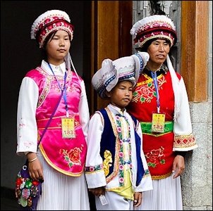
Yi girls Yunnan province is home to a third of all the ethnic minorities in China. Some groups originated from the region; others are believed to have come from the outside. The Bai people are believed to have lived in their homeland for 3,000 years. Archeological excavations in Kunming have unearthed 2000-year old weapons, drums, paintings and silver, jade and turquoise jewelry not that different from those of the Yi who have traditionally lived in the area.
The 26 ethnic minorities that make their home in Yunnan are the Achang, Bai, Benglong, Bonan, Bulang, Dai, De'ang, Drung, Dulong. Hani (Akha), Hui, Jinuo, Jingpo (Kachin in Burma), Lahu, Lisu, Miao (Hmong), Mongols, Naxi, Nu, Pumi, She, Tibetans, Wa, Yao, Yi, and Zhuang. If you add groups that are from outside the province, Yunnan is home to 51 of China's 56 ethnic minorities.
Each minority generally has its own distinctive costumes, culture and language, and many of them are related to minorities found in Laos, Burma, Vietnam and Thailand. It is mostly the women that wear traditional costumes. Yao girls, for example, wear black and blue tunic dresses and silver hoops around their necks and wrists. Their headdresses, which are often decorated with silver, look like deflated turbans wrapped with seashells and a scarf.
The Ethnic make up of the province is Han: 67 percent; Yi: 11 percent; Bai: 3.6 percent; Hani: 3.4 percent; Zhuang: 2.7 percent; Dai: 2.7 percent; Miao: 2.5 percent; Hui: 1.5 percent; Tibetan: 0.3 percent; De'ang (Ta'ang): 0.19 percent.
Binding of the wrists with cotton strings is a custom practiced by some ethnic groups in southern China such as the Jingpo, Hani and Dai. The tiger has great symbolic meaning among people who speak languages of the Yi branch of the Tibetan - Burmese family. The Yi are considered the "the people of the tiger". Among the Bai, Naxi, Mosuo, Pumi, Lahu and Lisu, the tiger also has great importance. Some recent publications suggest that the tiger is in fact, a tigress, and that the cult to the tiger among these peoples is an inheritance from the cult to the mother. Among the indigenous peoples that inhabit villages set up near a small grove that they consider sacred. Usually they believe that this forest is the place that the protective spirits of the village inhabit; they maintain taboos in order to impede any activity that can deteriorate it. [Source: Ethnic China ethnic-china.com *]
See MINORITIES IN SOUTHEAST ASIA AND SOUTH CHINA: factsanddetails.com
History of Yunnan
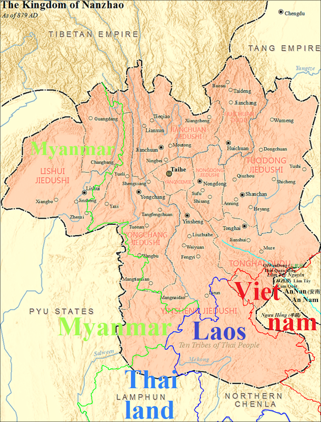
Yunnan became part of the Han Dynasty (206 B.C.-220 A.D.) during 2nd century B.C. It became the seat of a Tibeto-Burman speaking kingdom known as the Kingdom of Nanzhao in the 8th century A.D. Nanzhao was multi-ethnic, but the elite most likely spoke a northern dialect of Yi, which became established as the prestige dialect (see Nuosu language). The Mongols conquered the region in the 13th century.
Much of what is known about their past has been ascertained through studies of their languages, oral history, myths and Chinese records. Some groups were primarily hunters and gathers in the early stages of their development and adapted to agriculture relatively late and then practiced relatively primitive slash and burn agriculture rather than more sophisticated, irrigated, wet-land, rice agriculture.
It is believed that the many ethnic groups that many ethnic groups that live in Yunnan today are descendants of the Qiang tribes that 2,000 years ago inhabited the border region between Sichuan, Gansu and Sichuan provinces. There are numerous references to the frequent wars fought between the Chinese and the Qiang in the Han Dynasty (206 B.C." A.D. 220). Wars and natural disasters forced some Qiang branches to move to the South. The migration took place over at least one hundred years and covered more than 2,000 kilometers. [Source: Ethnic China ethnic-china.com *]
A late Zhou dynasty historian wrote: "the people of those five regions — the Middle states and the Jung, Yi, and other wild tribes around them — all had their severe natures, which they could not be made to alter. The tribes on the east were called Yi. They had their hair unbound, and tattooed their bodies. Some of them ate their food without it being cooked." The same historian also described tribes to the south, west and north that tattooed their foreheads, turned their feet inward, wore skins, and lived in caves.
Early Yunnan Culture
The discovery of a huge new 3,000-year-old neolithic site in Yunnan Province — located on the banks of Jian Lake between Lijiang and Dali — was announced in July 2008. Covering an area of four square kilometers, it is one of the largest Neolithic sites ever found. Thousands of artifacts and wooden poles have been unearthed. The poles, found 4.6 meters underground, were supports for buildings.
Reuters reported: “Thousands of ancient artifacts and wooden poles more than 3,000 years old have been unearthed in China's southern Yunnan province, possibly the world's largest site of a Neolithic community, local media reported. The poles, found standing 4.6 meters underground, were used as part of building structures for an ancient community that may have covered an area of 4 square km, the China Daily reported, citing Min Rui, a researcher at Yunnan Archaeological Institute, who is leading the excavation team. [Source: Reuters, July 22, 2008]
“The site could be older than the Hemudu community in Yuyao, in Zhejiang province, which is among the most famous in China and is believed to be the birthplace of society around the Yangtze River. An area of 1,350 square meters has already been uncovered and excavation is ongoing. "I was shocked when I first saw the site. I have never seen such a big and orderly one," Yan Wenming, history professor at Peking University, was quoted as saying. Excavation began in January, but the site was actually discovered five decades ago during the construction of a canal along the banks of the Jianhu Lake, about 500 km northwest of the provincial capital Kunming. Archaeologists have found more than 3,000 artifacts made of stone, wood, iron, pottery and bone, as well as more than 2,000 of the wooden posts.”
The site was given the name Haimenkou Prehistoric Site. According to Chinese Archaeology: “The Haimenkou Site is located at the synonymous village in Diannan District, Jianchuan County, Yunnan Province, at the southern side of the outlet of the Jian Lake. Two seasons of excavations were undertaken in 1957 and 1978. In January-May of 2008, the Institute of Cultural Heritage and Archaeology of Yunnan Province carried out a third season of excavation, during which it exposed an area of 1395 square meters. [Source: Chinese Archaeology, January 20, 2009, Translated by Zhang Liangren \=]
“The entire dimension of the Haimenkou site, as presently preserved, is 50,000 square meters, and the core area is 20,000 square meters. The three excavation seasons have uncovered dwellings, fire places, wooden post stumps, grayish-white stones, human bones, and postholes. The wooden post stumps and beams, which count over 4000 altogether, constitute two dwellings. The three seasons of excavation have uncovered artifacts made of ceramic, stones, bones, horns, teeth, bronze, iron, as well as animal bones and crop remains. The third season alone yielded 18 bronze artifacts. Cultural deposit in the excavation areas is roughly uniform. The uncovered artifacts allow us to build up a three-period chronology, the first one of its kind in the Jian Lake region. The first period is of the Neolithic Age and dates to 4000~3500BP; no bronze artifacts are found in this period. The second and third periods are of the early and middle Bronze Age and correspond to 3400~3100 and 3000~2500BP respectively. \=\
“The Haimenkou site is very important in the northwestern Yunnan and near the eastern Tibetan Plateau, throwing much light into the prehistoric human activities in this region. The two Bronze Age periods are roughly contemporaneous with the chronology of the Yinsuo Island site, but the two sites differ dramatically in material culture, manifesting a situation of cultural diversity. The lakeshore aboveground wooden dwellings found at the site are well preserved and large in dimension, a rare phenomenon in China. The millet remains testify that this crop had been disseminated southward from the Yellow River valley to northwestern Yunnan by the Bronze Age; the rice and wheat remains provide new information regarding the origin of the two crops. The bronze artifacts and casting molds, which are unearthed during the third season in an unequivocal stratigraphic context, describe an early metalworking site in northwestern Yunnan. In addition, the human and animal bones will surely provide rich information for archaeological, anthropological, and ethnographic studies.” \=\
Nanzhou and Dali Kingdom
In the A.D. sixth and seventh century, the area around Dali developed very quickly. The tribes inhabiting the Erhai Basin joined together to create political entities that become to be known as the Six Zhaos (Kingdoms). Among them was the Mengshe zhao—also called Nanzhao for being the southerner of these kingdoms. Established by Xinuolou in 649 in the present city of Weishan, it became the most powerful of these kingdoms. By 737 the other five zhaos were under the rule of Piluoge, who is considered the founder of the Nanzhao Kingdom. [Source: Ethnic China ethnic-china.com *]
In the A.D. 7th and 8th century, the Bai established a powerful kingdom south of Dali in Nanzhou after driving out the imperial Chinese army of the Tang dynasty (618-907). Extending across southern China and reaching into northern China, the Bai kingdom grew rich by controlling the important trade routes between China, Burma and India and helped the Chinese fight against the Tibetans. The Thais and a handful of Chinese and Southeast Asian ethnic groups descended from the members of the Bai kingdom.
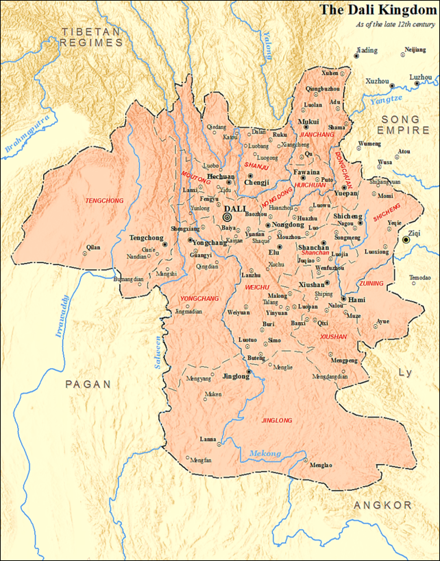
In the 10th century, the Nanzhou kingdom collapsed and was replaced by the Kingdom of Dali, which embraced 37 tribes and had good relations with China. It lasted until Kublai Khan's Mongol invasion in the 13th century. Agriculture was made easier with the introduction of Irish potatoes and maize in the 16th century and the adoption of high-altitude-cool-weather crops like buckwheat, barley, and oats. During Imperial Chinese times, local control was exercised by what were effectively warlords until the 1930s. As with other parts of China's southwest, Japanese occupation in the north during World War II forced a migration of majority Han people into the region.
See Nanzhao and Dali Kingdoms Under MINORITIES IN SOUTHEAST ASIA AND SOUTH CHINA: factsanddetails.com ; DALI: ITS ANCIENT CITY, BAI PEOPLE, LAKE ERHAI, CANGSHAN AND THE BUTTERFLY SPRING factsanddetails.com
Marco Polo in Yunnan
Of his travels in Yunnan, Marco Polo (1254-1324) wrote about local religious customs, shamanistic healing practices and the use of cowrie shells and salt as money, all of which have been verified by scholars. He also wrote about a giant snake with legs and a mouth "so large that it could well swallow a man." Some believe he was referring to crocodiles that lived in the region or to a local legend of a giant man-eating snake.
Marco Polo described people in Yunnanwith tattoos and gold-sheathed teeth. The tattoos were applied, he wrote, using "five needles joined together...they prick the flesh till the blood comes, and they rub in a certain black coloring stuff." The Dai that live in the area he visited have gold teeth and tattoos like those he described. Marco Polo also wrote "people are accustomed to eat the raw flesh of fowls, sheep, oxen and buffalo...the poorer sorts only dip it in a sauce of garlic mixed with good spice...they eat it as well as we do the cooked. The Bai people around Dali eat the same way today.
Describing the Yunnan city of Kunming in the 13th century, when it was under the rule of the Kingdom of Dali, Marco Polo wrote: "In it are found merchants and artisans, with a mixed population, consisting of idolaters, Nestorian Christians and Saracens or Mohametans...The land is fertile in rice and wheat...For money they employ the white porcelain shell, found in the sea, and which they also wear as ornaments around their necks." He also said, “The natives do not consider it an injury done to them when others have connection with their wives, providing the act is voluntary on the woman's part "

ethnic groups in Yunnan
Yunnan Under the Chinese
In imperial times many of the larger, more powerful ethnic groups such as the Dai operated under the tusi system in which local leaders (called “tusis”) were given charters and tacit approval by the Chinese government to govern in return for nominal recognition of imperial authority. The tusi system was a sort of state authorized feudal system in which peasants came under control of tusi landlords and were required to pay them half their harvest as taxes. The system survived for centuries and in some cases was used as an excuse by the powerful groups to subjugate less powerful ones.
Starting in Ming dynasty (1368–1644) China began replacing many of the native chiefs in the tusi system with Han Chinese officials, a policy that was continued under the Qing dynasty. Many minorities came under direct Chinese control. Some were under the control of a Chinese magistrate and a native leader.
After the Ming armies drove out the Mongols in the 14th century, many Chinese moved into the Dali area and intermarried with the Bai. According to the Chinese government: The Ming Dynasty (1368-1644) took power from the Yuan rulers in 1381. The Ming court removed local chieftains and replaced them with court officials. This kind of reform resulted in the weakening of the political and economic privileges of the local lords, brought freedom to the slaves and raised the enthusiasm of the peasants for farming. Those Bais and Hans who had emigrated were encouraged to return, while Hans from other areas were persuaded to settle there. This measure accelerated the development of the landlord economy of Bai society.In addition to the continuation of the Ming policy of dispatching officials from the central government, the Qing (1644-1911) court also appointed local officials and chieftains to rule over the Bais. Some Bai people in remote areas still suffered feudal exploitation and oppression at the time of liberation." [Source:]
After the Ming emperors consolidated their power in the Central Plains, China began exerting itself more in Yunnan. More Han Chinese immigrants arrived in the region. For the most part Chinese and Bai cohabit the region peacefully. Dali was the main political, economic and trading center in Yunnan. There were occasional uprisings, the most significant of which was the Muslim-lead Panthay Rebellion in the 19th century that lasted more than a decade before it was brutally put down. [Source: Ethnic China ethnic-china.com]
In 1874, a Hui Muslim named Du Wenxiu united the Bai, Naxi, Yi and Dai in a rebellion against the Qing dynasty. The rebellion was brutally put down in 1892. Missionaries arrived when the Burma Road was constructed nearby in 1937-38. In 1956, the Dali Baizu Autonomous Region was created under the Communists.
Burma Road

Chinese troops on the
Burma Road
The Burma Road (between Kunming and the Burma-India border) was the major overland supply route to China after the Japanese took over much of coastal China in 1937 and 1938 and blockaded its seaports. It was built at a break-neck pace, often by Chinese laborers forced to work for the Nationalists for two years without pay. When it was finished it was little more than a supply track that could only be used by trucks in the dry season.
The Burma Road was built by 160,000 Chinese laborers with virtually no machinery. One worker, who worked on the road between Ruili in Burma and Kunming in China told National Geographic, “It was not easy. I was a boy. In 1937 the engineers came through with stakes, marking where they wanted the roadway. We worked seven days a week, from sunrise to sunset." [Source: Donovan Webster, National Geographic, November 2003]
The Burma Road follows the Mekong for part of its route in China. Th road itself is pavement at first and then changes to rows of cobblestone the Chinese call corn-ear pavement. The trucks that ply the route are called Dong feng, (“East Wind”). The huge loads they carry are do heavy their brakes sometimes smoke when they go down hill. Sometimes, drivers put water on the wheels to cool them down.
What is called the Burma Road was actually two roads: 1) the roughly 600-mile-long Burma Road, built in 1937 and 1938 between Lashio, Burma and Kunming, China under Chiang kai-shek to bring supplies through a backdoor of China after the Japanese invaded China; 2) and the roughly 500-mile-long Ledo Road
The straight line distance from Ledo to Kunming is about 460 miles. The Burma and Ledo Roads, built through some of the world's most difficult terrain in India, Burma and China, covered more than twice that distance and hooked southward to avoid the Himalayas. The idea was ultimately to use the roads for an invasion of China and from China an invasion of Japan. Churchill called the entire project “an immense, laborious task, unlikely to be finished, until the need for it had passed." The project was not completed until just six months before the war ended.
For more on the Burma Road, See History — Mao. Early Communists, Japanese — World War II and China,
Tourism in Yunnan
Bai People
Yunnan Province, due to its beautiful landscapes, mild climate and colorful ethnic minorities, is one of China's major tourist destinations. Most visitors are Chinese tourists, although many foreign tourist also come.. Mainland tourists travel in huge masses with several million of them showing during national holidays. Small scale and environmentally friendly ecotourism has gained some traction in Yunnan. Some projects have been set up with help from international NGO's.
Tourism revenues have accounted for as much as 12,.6 percent of Yunnan’s provincial GDP and Kunming, the capital Yunnan Province, has hosted the China International Travel several times. In 2010, Yunnan welcomed over 2.3 million overseas tourists and the Yunnan Provincial Tourism Bureau aims to double that under its the 12th Five-Year Tourism Development Plan. Kunming added 11 new mid-to high-end hotels with an inventory of around 4,000 rooms between 2012 and 2016.
Yunnan attracts visitors with beautiful scenery, charming towns and interesting ethnic groups. Among its legendary places are the Three Parallel Rivers; Kunming, known as the Spring City; and the ancient city of Dali with nearby Erhai Lake. The traditional civilian residential houses in the plateau water city of Lijiang eraned it a UNESCO World Heritage Site designation. The town of Zhongdian changed its name to Shangri-La, and it jade-like lakes and snowcapped mountains almost live up to the name. Xishuangbanna is famous for peacock dances and rain forests. Magnificent Yulong, Haba and Meli attract hikers and mountaineers.
Yunnan Cuisine is fragrant, sweet, delicious and tender, with a distinctive sour and spicy taste. Famous local dishes include Bamboo Tube Chicken, Steam-Pot Chicken, Yiliang Stewed Duck, Three Kinds of Silvers with Fungus. Among the most famous local snacks are Sixi Stuffed Balls Made of Glutinous Rice Flour Served in Soup, and Taishi Cake. Kunming is noted for many local delicacies, including "Across the Bridge Rice Noodles" (guo qiao mi xian).
Road and rail transportation in Yunnan has improved greatly in recent decades. There is now fast-train service between Kunming, Dali and Lijiang that is connected to other cities of China. Even some of the most remote locations can be reached by plane. Many new highways have been built. Kunming, which is about 200 kilometers from Vietnam, serves as a transportation and commerce hub for South and Southwest China. Major roads connect city with Vietnam, Laos, Thailand, and Myanmar.
Major roads link Kunming with cities in Yunnan, Sichuan, Guizhou, Guangxi provinces, and Tibet.. Among the main roads are: 1) Kunming-Wanding Highway, also known as the Burma Road; 2) Yunnan-Tibet Highway, via Dali, Lijiang, and Diqing; 3) Kunming-Hekou Highway, via the Stone Forest, Kaiyuan and Mengzi; ) Kunming-Daluo Highway, via Yuxi, Mojiang, Simao and Jinghong; 4) Yunnan-Guizhou Highway, via Qujing; 5) Kunming-Baise Highway, the Stone Forest, Kaiyuan, Yanshan, Wenshan and Funing; and 6 ) Kunming-Suijiang Highway, via Dongchuan and Zhaolong
Image Sources: Wikimedia Commons, ethnic map Johomaps
Text Sources: CNTO (China National Tourist Organization), China.org, UNESCO, reports submitted to UNESCO, Wikipedia, Lonely Planet guides, New York Times, Washington Post, Los Angeles Times, National Geographic, China Daily, Xinhua, Global Times, The New Yorker, Time, Newsweek, Bloomberg, Reuters, Associated Press, AFP, Compton's Encyclopedia and various books and other publications.
Updated in October 2022