DESERTS
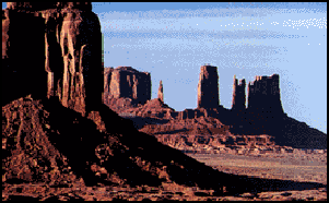
A desert is defined as a place where more water evaporates than falls as rain during an average year. It also defined as a place where there is not enough vegetation to support human beings. Desert areas that do support people are usually built around oases or some artificial water source.
Most deserts receive less than five inches of rain a year. The rain that does fall is often spotty. Often times months or years pass without rain. Sometimes half a year's worth of rain can fall in a single storm. And, when it does rain one place may receive a lot of rain and another place nearby may not receive any.
Deserts cover about 20 percent of the world's land surface, or about a third of the surface if semi-deserts and dry steppes are included. People live only where water is available. Vast areas of the desert are uninhabited.
Deserts may be hot, they may be cold. They may be regions of sand or vast areas of rocks and gravel peppered with occasional plants. But deserts are always dry. Deserts are natural laboratories in which to study the interactions of wind and sometimes water on the arid surfaces of planets. They contain valuable mineral deposits that were formed in the arid environment or that were exposed by erosion. Because deserts are dry, they are ideal places for human artifacts and fossils to be preserved. Deserts are also fragile environments. The misuse of these lands is a serious and growing problem in parts of our world. [Sources: “Deserts: Geology and Resources” by A.S. Walker, United States Geological Survey]
Dry areas created by global circulation patterns contain most of the deserts on the Earth. The deserts of our world are not restricted by latitude, longitude, or elevation. They occur from areas close to the poles down to areas near the Equator. The People's Republic of China has both the highest desert, the Qaidam Depression that is 2,600 meters above sea level, and one of the lowest deserts, the Turpan Depression that is 150 meters below sea level. Deserts are not confined to Earth. The atmospheric circulation patterns of other terrestrial planets with gaseous envelopes also depend on the rotation of those planets, the tilts of their axes, their distances from the Sun, and the composition and density of their atmospheres. Except for the poles, the entire surface of Mars is a desert. Venus also may support deserts.
Websites and Resources: United States Geological Survey usgs.gov/gip/deserts ; Desert USA (good info on the world’s deserts); desertusa.com/life ; United Nations Global Desert Outlook unep.org/geo/gdoutlook ; Desert Biome article, University of California, Berkeley Desert Biome ; Blue Planet Biomes (about U.S. deserts) blueplanetbiomes.org ; Wikipedia article Wikipedia ;National Geographic online article National Geographic Oxfam Cool Planet oxfam.org.uk/coolplanet ; Sand Dunes article waynesword.palomar.edu ; United States Geological Survey usgs.gov/gip/deserts
Types of Deserts
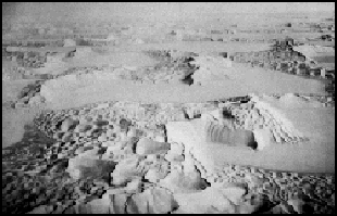
Empty Quarter in Arabia Deserts are classified by their geographical location and dominant weather pattern as trade wind, midlatitude, rain shadow, coastal, monsoon, or polar deserts. Former desert areas presently in nonarid environments are paleodeserts, and extraterrestrial deserts exist on other planets. [Sources: “Deserts: Geology and Resources” by A.S. Walker, United States Geological Survey]
Trade wind deserts: The trade winds in two belts on the equatorial sides of the Horse Latitudes heat up as they move toward the Equator. These dry winds dissipate cloud cover, allowing more sunlight to heat the land. Most of the major deserts of the world lie in areas crossed by the trade winds. The world's largest desert, the Sahara of North Africa, which has experienced temperatures as high as 57̊ C, is a trade wind desert.
Midlatitude deserts occur between 30̊ and 50̊ N. and S., poleward of the subtropical highpressure zones. These deserts are in interior drainage basins far from oceans and have a wide range of annual temperatures. The Sonoran Desert of southwestern North America is a typical midlatitude desert.
Rain shadow deserts are formed because tall mountain ranges prevent moisture-rich clouds from reaching areas on the lee, or protected side, of the range. As air rises over the mountain, water is precipitated and the air loses its moisture content. A desert is formed in the leeside "shadow" of the range.
Coastal deserts generally are found on the western edges of continents near the Tropics of Cancer and Capricorn. They are affected by cold ocean currents that parallel the coast. Because local wind systems dominate the trade winds, these deserts are less stable than other deserts. Winter fogs, produced by upwelling cold currents, frequently blanket coastal deserts and block solar radiation. Coastal deserts are relatively complex because they are at the juncture of terrestrial, oceanic, and atmospheric systems. A coastal desert, the Atacama of South America, is the Earth's driest desert. In the Atacama, measurable rainfall--1 millimeter or more of rain--may occur as infrequently as once every 5-20 years.
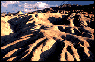
Death Valley Monsoon deserts: "Monsoon," derived from an Arabic word for "season," refers to a wind system with pronounced seasonal reversal. Monsoons develop in response to temperature variations between continents and oceans. The southeast trade winds of the Indian Ocean, for example, provide heavy summer rains in India as they move onshore. As the monsoon crosses India, it loses moisture on the eastern slopes of the Aravalli Range. The Rajasthan Desert of India and the Thar Desert of Pakistan are parts of a monsoon desert region west of the ranqe.
The Indus River floodplain, lower left, is the western border of the Thar Desert. This Landsat image of the monsoon desert shows small patches of sand sheets in the upper right, with three types of dunes; some dunes are almost 3 kilometers long.
Polar deserts are areas with annual precipitation less than 250 millimeters and a mean temperature during the warmest month of less than 10̊ C. Polar deserts on the Earth cover nearly 5 million square kilometers and are mostly bedrock or gravel plains. Sand dunes are not prominent features in these deserts, but snow dunes occur commonly in areas where precipitation is locally more abundant. Temperature changes in polar deserts frequently cross the freezing point of water. This "freeze-thaw" alternation forms patterned textures on the ground, as much as 5 meters in diameter.
Paleodeserts: Data on ancient sand seas (vast regions of sand dunes), changing lake basins, archaeology, and vegetation analyses indicate that climatic conditions have changed considerably over vast areas of the Earth in the recent geologic past. During the last 12,500 years, for example, parts of the deserts were more arid than they are today. About 10 percent of the land between 30 degrees N. and 30 degrees S. is covered now by sand seas. Nearly 18,000 years ago, sand seas in two vast belts occupied almost 50 percent of this land area. As is the case today, tropical rain forests and savannahs were between the two belts.
Fossil desert sediments that are as much as 500 million years old have been found in many parts of the world. Sand dune-like patterns have been recognized in presently nonarid environments. Many such relict dunes now receive from 80 to 150 millimeters of rain each year. Some ancient dunes are in areas now occupied by tropical rain forests.
Extraterrestrial deserts: Mars is the only other planet on which we have identified wind-shaped (eolian) features. Although its surface atmospheric pressure is only about one-hundredth that of Earth, global circulation patterns on Mars have formed a circumpolar sand sea of more than five million square kilometers, an area greater than the Empty Quarter of Saudi Arabia, the largest sand sea on our planet. Martian sand seas consist predominantly of crescent-shaped dunes on plains near the perennial ice cap of the north polar area. Smaller dune fields occupy the floors of many large craters in the polar regions.
Grasslands and Steppes
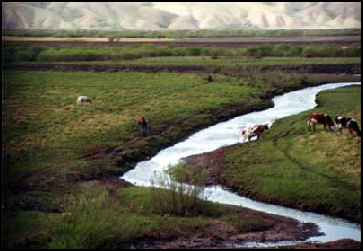
Mongolian steppe The famous steppe of Central Asia is 3000-mile-long, flat or gently rolling grassland, averaging 500 miles in width. It is mostly treeless except for areas along riverbanks. It's name is derived from “stepi” , "meaning plain.
The Central Asian steppe stretches from Mongolia and the Great Wall of China in the east to Hungary and the Danube River in the west. It is bounded by the taiga forest of Russia to the north and by desert and mountains to the south. It is located at about same latitude as the American plains and embraces a dozen countries, including Russia, China, Mongolia, Kazakhstan, Kyrzgzstan and several other former Soviet Republics.
Describing the steppes, Polish Nobel laureate Henry Sienkiewicz wrote in “With Fire and Sword”, "The steppes are wholly desolate and unpeopled yet filled living menace. Silent and still yet seething with hidden violence, peaceful in their immensity yet infinitely dangerous, these boundless spaces were a masterless, untamed country created foe ruthless men who acknowledge no one as their overlord."
Much of the steppe lies on humus-rich black soul that is ideal for growing grains such as wheat (which are kinds of grass). The soil in Kazakhstan is mostly fertile. In the north “chernoze” , is dominate. In the south “chermist” soils are common. In the deserts there is a mix of red-brown, grey-brown and sandy soils. The poor yellow steppe soil is much less fertile than rich black earth found in southern Russia and Ukraine. When the topsoil is stripped of vegetation it becomes dusty and is easily blown away in the wind.
The Central Asian steppe doesn’t receive very much rain. The soil is dry and dusty. For the most part the steppe and desert is not suitable for agriculture unless expensively irrigated. Grassland soil and plants store large amounts of carbon dioxide. When they are burned they release large amounts of carbon dioxide onto the atmosphere and contribute to global warming,
See Steppe Plants, Plants
Wind, Geology and Deserts
Eolian processes pertain to the activity of the winds. Winds may erode, transport, and deposit materials, and are effective agents in regions with sparse vegetation and a large supply of unconsolidated sediments. Although water is much more powerful than wind, eolian processes are important in arid environments. [Sources: “Deserts: Geology and Resources” by A.S. Walker, United States Geological Survey]
Under Eolian erosion ind erodes the Earth's surface by deflation, the removal of loose, fine-grained particles by the turbulent eddy action of the wind, and by abrasion, the wearing down of surfaces by the grinding action and sand blasting of windborne particles.
Most eolian deflation zones are composed of desert pavement, a sheetlike surface of rock fragments that remains after wind and water have removed the fine particles. Almost half of the Earth's desert surfaces are stony deflation zones. The rock mantle in desert pavements protects the underlying material from deflation.
A dark, shiny stain, called desert varnish or rock varnish, is often found on surfaces of some desert rocks that have been exposed at the surface for a long period of time. Manganese, iron oxides, hydroxides, and clay minerals form most varnishes and provide the shine. Deflation basins, called blowouts, are hollows formed by the removal of particles by wind. Blowouts are generally small, but may be up to several kilometers in diameter.
In Eolian transportation systems particles are transported by winds through suspension, saltation, and creep. Small particles may be held in the atmosphere in suspension. Upward currents of air support the weight of suspended particles and hold them indefinitely in the surrounding air. Typical winds near the Earth's surface suspend particles less than 0.2 millimeters in diameter and scatter them aloft as dust or haze.
Saltation is downwind movement of particles in a series of jumps or skips. Saltation normally lifts sand-size particles no more than one centimeter above the ground, and proceeds at one-half to one-third the speed of the wind. A saltating grain may hit other grains that jump up to continue the saltation. The grain may also hit larger grains that are too heavy to hop, but that slowly creep forward as they are pushed by saltating grains. Surface creep accounts for as much as 25 percent of grain movement in a desert.
Ergs, Wadis, Hamadas and Other Desert Formations
A sand sea is a large area covered by sand dunes. Sand seas are difficult to cross and virtually void of life. Caravans have traditionally given them a wide berth. Ergs are basins filled with sand dunes and sand seas. Erg is an Arabic word for sand sea.
A bolson is a gravel-covered basin located between rain-blocking mountain ranges. Much of the material in them — gravel, rocks and sand — have been deposited in alluvial fans by downpours.
Hamadas are stony upland plateaus, often separated by ergs. Many hamadas are broad, flattish, dome-shaped areas. Mesas are flat-topped hills with steep sides. Buttes are small hills. They created where desert streams and wind wear away at rocks in valleys.
Wadis are canyons or dry stream beds that are dry except when it rains. They fill with water only during sudden storms and occasional periods of rain. They sometimes flood. It is not a good idea to camp in them.
Wadis have fairly rich soil and accessible water. Plants and waters are often found in them. Water is drilled in them. Oases often are formed in places where many wadis empty or where large amounts of underground water flow beneath a wadi. Wadi is an Arabic term. They are called gullies in the United States and “arroyos” in Latin America.
Rock Formations
desert wind
measuring devise Wind-driven grains abrade landforms. Grinding by particles carried in the wind creates grooves or small depressions. Ventifacts are rocks which have been cut, and sometimes polished, by the abrasive action of wind.
Pinnacles, needles, arches and other fantastic rock formations are found in deserts. Some rock formations are created by wind erosion. Winds blast horizontal grooves in the cliff faces of mountains. The grooves get deeper and rock gets weaker. Without vegetation the rock breaks and crumbles into sand. Others are created by water erosion from quick storms and flash floods, or by rain that occurred thousands of years earlier when water and rain were more plentiful.
Some unusual rock formations have been sculpted smooth by wind and sand carried by wind. Mushroom-shaped rock formations are created from lose sandstone or chalk by cycles of hot and cold and wet and dry, combined with blowing sand, which causes the sloughing of shards. It is a myth that windblown sand shapes of the majority of desert land forms. Wind usually doesn’t have the power to lift particles larger than dust grains. Most are caused by water erosion or chemical reactions caused by water and/or chemicals in the rocks that react to water.
Yardangs
Yardangs are snake-like rock ridges created by scouring sand-laden winds. These aerodynamically-stable structures look like upside-down boat hulls, each with its prow end pointed into the wind. Yardangs are up to tens of meters high and kilometers long. Their forms have been streamlined by desert winds. The famous sphinx at Giza in Egypt may be a modified yardang.
According to a report submitted to UNESCO: “The internationally recognized geomorphic term “Yardang” was originated from Uygur language which means small hill with steep escarpments, and proposed by Swedish explorer Sven Hedin as a formal technical expression when he was exploring the Lop Nor region of Northwest China in the early 20th century. It represents the ridge-like, castle-like, or hill-like erosional landform with considerable scale in extremely arid region, or some basins in arid region, where the non-completely consolidated sediments were sculptured by the wind and flood. [Source: National Commission of the People's Republic of China for UNESCO]
China owns the largest distribution of Yardangs with about 20,000 square kilometers in total area. The most representative Yardangs on earth are particularly concentrated in basins in Xinjiang and west of Gansu Province, as well as in the Qaidam Basin in Qinhai Province. These basins are located in the hinterland of the Eurasian continent under an extremely arid temperate continental climate.
See Separate Article DUNHUANG: SAND DUNES, SILK ROAD SITES, YARDANGS AND MOGAO CAVES factsanddetails.com
Studying Deserts
The world's deserts are generally remote, inaccessible, and inhospitable. Hidden among them, however, are hydrocarbon reservoirs, evaporites, and other mineral deposits, as well as human artifacts preserved for centuries by the arid climate. In these harsh environments, the information and perspective required to increase our understanding of arid-land geology and resources often depends on remotesensing methods. Remote sensing is the collection of information about an object without being in direct physical contact with it. [Sources: “Deserts: Geology and Resources” by A.S. Walker, United States Geological Survey]
Desert studies still are hampered in many regions by lack of accurate climate data. Most desert weather stations are in oases surrounded by trees and buildings and have been subjected to many location and elevation changes throughout the life of the station. Data from oases do not reflect conditions from the surrounding desert. A wide variety of instruments has been used to record measurements over varying lengths of time and in different formats, making data difficult to interpret and compare.
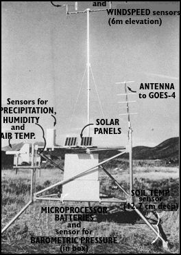
To overcome some of these problems in deserts of the American Southwest, the U.S. Geological Survey (USGS) established its Desert Winds Project to measure in a standard format several key meteorologic characteristics of arid lands. Project scientists have successfully established instrument stations to measure windspeed, including peak gusts, which alter the landforms the most. A station recorded a windstorm near Vicksburg, Arizona, for example, with peak gusts of almost 150 kilometers per hour. Using low-maintenance, automatic, solar-powered sensors, the stations also measure wind direction, precipitation, humidity, soil and air temperatures, and barometric pressure at specific heights above the surface. Data are sampled at 6-minute intervals and transmitted every 30 minutes to a Geostationary Operational Environmental Satellite (GOES). From GOES, the data are transmitted to the USGS laboratory in Flagstaff, Arizona.
The Desert Winds Project's investigators combine analyses of data with detailed geologic field studies and repetitive remote-sensing coverage in order to investigate and understand the long-term changes produced by wind in deserts of differing geologic and climatic types.
Remote Sensing of Arid Lands
satellite image of
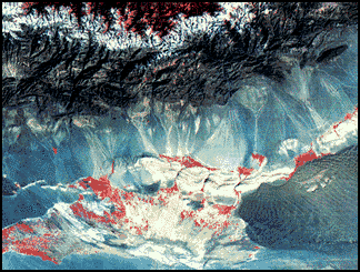
Turpan Depression The Landsat Thematic Mapper (TM) acquires data in seven bands of the electromagnetic spectrum. On this image, white and yellow colors indicate rocks rich in clay minerals and limonite in rocks of red and yellow hues. The large concentrations of limonite and clays may indicate mineral deposits exposed at the surface or buried up to several thousand feet below it. [Sources: “Deserts: Geology and Resources” by A.S. Walker, United States Geological Survey]
Remote-sensing instruments in Earth-orbit satellites measure radar, visible light, and infrared radiation. Radar imaging systems provide their own source of electromagnetic energy, so they can operate at any time of day or night. Additionally, clouds and all but the most severe storms are transparent to radar.
The first Shuttle Imaging Radar System (SIR-A), flown on the U.S. space shuttle Columbia in 1981, recorded images that show buried fluvial topography, faults, and intrusive bodies otherwise concealed beneath sand sheets and dunes of the Western Desert in Egypt and the Sudan. Most of these features are not visible from the ground. The radar signal penetrated loose dry sands and returned images of buried river channels not visible at the surface. These images helped find new archeologic sites and sources of potable water in the desert. These "radar rivers" are the remnants of a now vanished major river system that flowed across Africa some 20 million years before the development of the Nile River system. Radar imagery also is a powerful tool for exploring for placer mineral deposits in arid lands.
In 1972, the United States launched the first of a group of unmanned satellites collectively known as Landsat. Landsat satellites carry sensors that record "light," or portions of the electromagnetic spectrum, as it reflects off the Earth. Landsat acquires digital data that are converted into an image.
The scarcity of vegetation makes spectral remote sensing especially effective in arid lands. Rocks containing limonite, a hydrous iron oxide, may be identified readily from Landsat Multispectral Scanner data. The Landsat Thematic Mapper (TM) has increased our ability to detect and map the distribution of minerals in volcanic rocks and related mineral deposits in arid and semiarid lands.
More than a million images of Earth have been acquired by the Landsat satellites. A Landsat image may be viewed as a single band in black-and-white, or as a combination represented by three colors, called a color composite. The most widely used Landsat color image is called a false-color composite because it reproduces the infrared band (invisible to the naked eye) as red, the red band as green, and the green band as blue. Healthy vegetation in a false-color composite is red.
Image Source: United States Geological Survey (USGS) usgs.gov/gip/deserts except by Mongolia steppe by Perechon
Text Sources: "Deserts Geology and Resources" by A.S. Walkers, USGS Online publication; Rick Gore, National Geographic, November 1979 [┵]; New York Times, Washington Post, Los Angeles Times, Daily Yomiuri, Times of London, National Geographic, The New Yorker, Time, Newsweek, Reuters, AP, Lonely Planet Guides, Compton’s Encyclopedia and various books and other publications.
Last updated May 2022
