GLACIERS
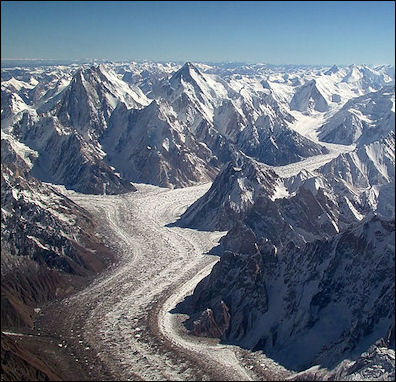
Baltoro glacier, near K2 in Pakistan A glacier is a body of ice showing evidence of movement as reported by the presence of ice flowline, crevasses, and recent geologic evidence. Sometimes a glacier is viewed as a great river of ice that forms in places where snowfall exceeds melting. [Source: Mostly from USGS and newspaper articles]
Glaciers exist where, over a period of years, snow remains after summer's end. They exist in environments of high and low precipitation and in many temperature regimes; they are found on all the continents except Australia and they span the globe from high altitudes in equatorial regions to the polar ice caps. There is a delicate balance between climatic factors that allows snow to remain beyond its season.
Glaciers begin as snowflakes before being compressed into ice. As gravity pulls these masses of ice, rock, and sediment downhill, they shape the landscape. Glaciers store more than half of the world’s freshwater and give us clues about our changing climate. Large glaciers take thousands of years to become established. They begin as snowfields, large deposits of snow that exists throughout the year but are distinguished from glaciers by the fact they don't move downhill. [Source: U.S. National Park Service]
In direct sunlight or warm weather the snow on the surface of a glacier melts. The dripping water and pressurized snow becomes ice as layers of snow are piled on top of them. When the ice and snow of snowfield become significantly high, usually at a depth of around 60 feet, deep, the entire mass begins moving downhill and becomes a glacier. Like rivers they flow down through places that offer the least resistance, usually downward-slopping valleys.
Himalayas Wikipedia article on the Himalayas Wikipedia ; Making of Himalayas geol.unibas ; Himalayas site himalayas.dk ; Mt. Everest : Wikipedia Wikipedia National Geographic National Geographic Mount Everest.net Mont Everest.net Summit Post Summit Post ; Glaciers: All About Glaciers nsidc.org ; Wikipedia article on Glaciers Wikipedia ; Wikipedia article on Avalanches Wikipedia ;
See Separate Articles: GLACIER COMPONENTS FEATURES AND LANDFORMSfactsanddetails.com; HIMALAYAN GLACIERS: IMPORTANCE, AVALANCHES AND DANGEROUS FLOODS factsanddetails.com; AVALANCHES factsanddetails.com; MOUNTAIN GLACIERS AND GLOBAL WARMING factsanddetails.com TIBET, THE HIMALAYAS, MELTING GLACIERS AND GLOBAL WARMING factsanddetails.com; HIMALAYAS factsanddetails.com ; MOUNTAINS: TYPES, GEOLOGICAL FEATURES AND MEASURING THEM factsanddetails.com; MT. EVEREST: NAMES, GEOLOGY, WEATHER AND HEIGHT MEASURING ISSUES; factsanddetails.com
Nature of Glaciers and Glacial Snow and Ice
A few days of falling, snowflakes have noticeably begun to change. The snowflakes are compressed under the weight of the overlying snowpack. Individual crystal near the melting point have slick liquid edges allowing them to glide along other crystal planes and to readjust the space between them. Where the crystals touch they bond together, squeezing the air between them to the surface or into bubbles. During summer we might see the crystal metamorphosis occur more rapidly because of water percolation between the crystals. By summer's end the result is firn — a compacted snow with the appearance of wet sugar, but with a hardness that makes it hard to move. Several years are usually required for the snow to settle and to season into the substance we call glacier ice.
Glacier ice: Snowflakes are compressed under the weight of the overlying snowpack. Individual crystal near the melting point have slick liquid edges allowing them to glide along other crystal planes and to readjust the space between them. Where the crystals touch they bond together, squeezing the air between them to the surface or into bubbles. During summer we might see the crystal metamorphosis occur more rapidly because of water percolation between the crystals. By summer's end the result is firn — a compacted snow with the appearance of wet sugar, but with a hardness that makes it resistant to all but the most dedicated snow shovelers! Several years are usually required for the snow to settle and to season into the substance we call glacier ice. Above the firnline, snow that falls each year packs down and changes into glacier ice as air is slowly forced out of it.
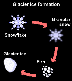
Glacial ice formation Firn is old snow that has been recrystalized into a more dense substance. Firn has a density greater than 0.55. Snowflakes are compressed under the weight of the overlying snowpack. Individual crystal near the melting point have slick liquid edges allowing them to glide along other crystal planes and to readjust the space between them. Where the crystals touch they bond together, squeezing the air between them to the surface or into bubbles. During summer we might see the crystal metamorphosis occur more rapidly because of water percolation between the crystals. By summer's end the result is firn -- a compacted snow with the appearance of wet sugar, but with a hardness that makes it resistant to all but the most dedicated snow shovelers! Several years are usually required for the snow to settle and to season into the substance we call glacier ice.
Firnline: A line that marks the limit on a mountain above which snow persists from one winter to the next is called the annual snowline, and this line on a glacier is called the firnline. Above the firnline, snow that falls each year packs down and changes into glacier ice as air is slowly forced out of it. This part of the glacier is its accumulation area where more snow falls each year than is lost by melting. Below the firnline is the ablation area, where melting predominates.
We can best determine the health of a glacier by looking at its mass balance. Each year glaciers yield either a net profit of new snow, a net loss of snow and ice, or their mass may remain in equilibrium. Scientists divide each glacier into upper and lower sections termed the accumulation area, where snowfall exceeds melting during a year; and the ablation area, where melting exceeds snowfall. An equilibrium line, where mass accumulation equals mass loss, separates these areas. You can see it as the boundary between the winter's snow and the older snow or ice surface. Its altitude changes annually with the glacier's mass balance. To find mass balance, scientists measure the area of each region and observe amounts of accumulation and ablation relative to preset stakes. After density measurements are made they may calculate how much water has been added or lost to the glacier. After a series of positive mass balance years, the glacier may respond to the increased thickness by making a glacial advance downvalley. A series of negative years may cause a glacial retreat, meaning that the terminus is melting faster than the ice is moving downvalley.
Types of Glaciers
There are two kinds of glaciers: 1) mountain glaciers , which flow down hill in between mountains; and 2) continental glaciers, country-size glaciers that cover large masses of land. These days the continental glaciers are found exclusively on Greenland and Antarctica. During Ice Ages, they covered much of northern Europe and North America.
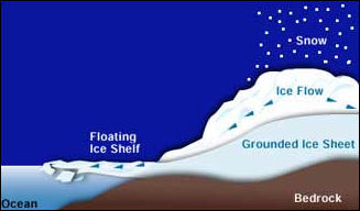
Ice Sheets are continental-scale bodies of ice. Although the only two modern-day ice sheets are in Greenland and Antarctica, much of northern North America, Europe and Asia were shaped by ice sheets during the last ice age (20,000 years ago), Ice sheets very large (greater than 50,000 square kilometers or 19,305 square miles in area) ice masses that accumulate in extensive, high elevation catchment areas. They are drained by smaller outlet glaciers or ice streams that flow out from them in different directions. Ice-sheet-shaped landscapes cover large parts of the northern latitudes today. [Source: U.S. National Park Service]
ice graphic
Ice Fields and Ice Caps are smaller than ice sheets (less than 50,000 square kilometers or 19,305 square miles in area). They are also large bodies of ice that collect in high elevation catchment areas and are drained by smaller outlet glaciers. Some drain into the fjords and lowland valleys. Whether is an ice field or an ice cap depends on how much the ice flow is dictated by the surrounding topography: Ice fields have mountains and ridges that jut out above the ice and influence its flow. Ice caps submerge the land beneath them, forming a high dome of slow-moving ice that spreads out from its center.
Tidewater and Freshwater Glaciers are formed on land but terminate in bodies of water. They often calve to produce floating chunks of glacier ice — icebergs. In these water-terminating glaciers, calving often accounts for the majority of the glacier's ablation (ice loss). Tidewater glaciers can flow directly into the ocean in an open coast locations; they also can discharge into steep-walled fjords. In temperate latitudes, water-terminating glaciers can be among the fastest-flowing in the world. Their high speeds endow them with a high capacity for sculpting and carving the landscape.
Ice shelves are thick plates of ice protruding from the land and floating on the sea are found in Antarctica and Greenland. Their relationship with glaciers is not well understood.
Valley and Piedmont Glaciers originate in the high alpine and terminate on land. They often flow through deep bedrock valleys that confine the ice on either side. Over time, they carve and shape these valleys. If a valley glacier spills out of the mountains, onto the flat foreland, the ice often spreads to form a lobe. Then it is called a piedmont glacier.
Rock glaciers are glacier-like landforms that often heads in a cirque and consists of a valley-filling accumulation of angular rock blocks. Rock glaciers have little or no visible ice at the surface. Ice may fill the spaces between rock blocks. Some rock glaciers move, although very slowly. Rock Glaciers are often mantled with a thick layer of rock and debris. This rock and debris shields them from ablation (melting), which means they can persist in areas where meltrates might be too high to sustain large alpine glaciers. For this reason, they can be found in many high mountain areas,
Rock glaciers may not look like glaciers at all at first sight: That is because of the thick layer of rock and debris. What the actual flowing ice in a rock glacier looks like and how these glaciers form in the first place is subject to debate. Some scientists think that the ice is likely very similar to that of other glaciers and the main difference between them is that rock glaciers are covered in rocks at the surface. Others think they probably have high concentrations of rocks throughout and that the ice just binds these rocks together, creating a mass that can flow downslope like a glacier. Either way, rock glaciers are flowing masses, and they form distinct lobes that look much like other kinds of glaciers.
Alpine Glaciers
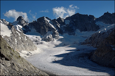
Forno glacier in the Alps Alpine Glaciers originate high in the mountains and flow downslope. When they form in small bowls with steep sides or headwalls (cirques), they are known as cirque glaciers. A typical cirque glacier. From their high elevation origins, alpine and cirque glaciers may flow into ice falls or valley glaciers, or they may terminate in the mountains. Small alpine and cirque glaciers can sometimes be found nestled beneath the high peaks.
A typical Alpine glacier resembles a hand. The palm is the main part of the glacier and where snow is accumulating and turning into ice. The fingers, sometimes called tongues or snouts, are rivers of ice that flow down various valleys and out of the mountains.
Tributary glaciers are similar to the streams that feed a river. They are created in reaches of the mountains, where they scrape off rock and pick up gravel and carry them with into the main glacier, resulting in the twisting, parallel black lines that you often see in large glaciers.
Crevasses are large cracks that occur in glaciers. Icefalls are areas where the glacier is moving relatively quickly and breaking apart, producing large areas of crevasses and jagged ice. Calving refers to large pieces of ice falling off the end of glaciers. This is usually associated with glaciers that terminate in bodies of water, which causes the ice to melt and fracture more quickly. After a calved piece of ice falls into the water it becomes an iceberg.
Moraines are the walls of debris that mark the edge of major Alpine glacier tongues. When the ice melts at the bottom of a glaciers rock and soil are deposited. Over time large amounts of this debris accumulate into moraines.
Advancing and Retreating Glaciers
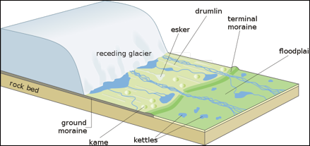
Receding glacier
Glacial advance is the net movement of glacier terminus downvalley. Advance occurs when the rate of glacier flow downvalley is greater than its rate of ablation. Advances are characterized by a convex-shaped terminus. Glacial retreat is the net movement of the glacier terminus upvalley. Retreat results when the glacier is ablating at a rate faster than its movement downvalley. Retreating termini are usually concave in shape.
Glaciers flow like rivers but at a much slower rate. Slowing-moving ones move at a rate of a few inches a day while fast-moving ones move several feet a day. Some glaciers don’t move. They are referred to a “cold glaciers” because they are frozen to the bed.
An advancing glacier is one that it is getting longer because the amount of snow that falls at the top of the glacier it exceeds the amount of melting at the bottom. A receding, or treating, glacier is one that it is getting shorter because the amount of snow that falls on it is less than the amount of melting.
Most mountain glaciers have an upper zone, where the accumulation of snow outpaces melting, and a lower zone where the opposite is true. How far down the mountain a glacier extends depends on the equilibrium snowline — the boundary between the upper zone and the lower zone, which roughly corresponds the place where the temperature reaches the freezing point.. Sometimes tongues of the glacier extends below the equilibrium snowline. The size of a glacier is defined by the balance between the melting and downward push of the glacier.
Glacier Movement and Mechanics
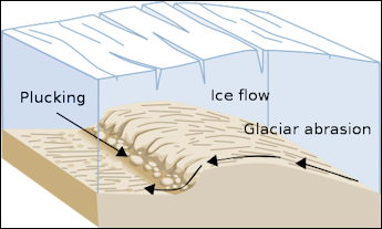
Glaciers have been likened to mighty rivers of ice. Although they move many times more slowly, glaciers have equivalent changes in flow rate and often form falls of fast-moving ice above slow-moving ice pools. Glaciers flow faster down their centers than at ice margins, and more quickly at the surface than at the bed.
How fast a glacier moves is mostly dependent on the thickness of the ice, and on the angle of its surface slope. Glacier speeds vary when changes are made in this geometry. They respond to excessively high seasonal snow accumulations by generating bulges of thicker ice that may move downvalley many times faster than the glacier's normal velocity.
Friction between the glacier, its sediments and the rock beneath the glacier act as a brake and keep the glacier from flowing faster than it otherwise might. Scientists have long wondered why glaciers don’t slide at much faster rate. Some had speculated that bumps in the bedrock help to hold them up but recent data suggests that friction does most of the work. Water has a lubricating effect. Glaciers experiencing a lot of melting often move very fast.
As the snow descends into a glacier and more snow piles on top of it, applying pressure, its crystal structure breaks down and it changes to ice. When the ice reaches depths of over 2,000 feet it becomes so compacted that if it is brought to the surface and mishandled it will explode. Sometimes the ice turn brilliant blue color. Green icebergs have been spotted.
Glacier ice much more plastic than the ice in freezers. It is constant motion: compressed by ice above and pushed downhill by its own weight. Glaciers groan, creak and crash as chunks of ice within the glacier bulge, press and rub against one another. On sunny or warm days, millions of gallon of snowbell filter down through a glacier, raising the water pressure where it meets the rock. When the top of a glacier melts the water trickles down and reduces friction where the glacier meets the Earth and lubricates the glacier, causing it to slide faster.
Glaciers are fickle beasts. Glaciers in the same climate area often behave differently. Veteran glaciologist Ian Allison told Reuters, “because the fluctuations that occur in the front depends on how long it takes to transfer the mass from the top of the glacier to the bottom...you might have an area where all the small glaciers are rapidly retreating but big glaciers are still coming forward because they are still integrating changes that happened maybe 50 years ago.”
Sometimes “icequakes” are caused when massive glaciers in Greenland, Antarctica and Alaska lurch downslope and suddenly stop, shaking the Earth below it. Seismographs in different places around the globe can pick up the vibrations from these events which have a different signature than earthquakes. The glacial icequakes occur most frequently in the late summer, presumably when they the glaciers are moving the most due to melting of ice. The number of icequakes is increasing, presumably because of global warming.
Dangerous Glacier Lakes
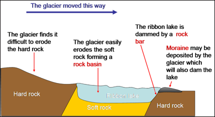
Ribbon lake
Already increases in melting have caused some lakes in Nepal to overflow their banks and damage villages and hydroelectric facilities. Some farmers have prospered with a windfall of water that has flowed their way from melting glaciers.
Some Himalayan lakes are growing at a rapid pace as glaciers melt. The Tsh Rolpa lake in the Dolaka district in Nepal has grown from about a quarter of a square kilometer in the 1950s to 1½ square kilometers today. The Raphstreng Tsho glacial lake in Bhutan was 1.6 kilometers long and 80 meters deep in 1986 and today in two kilometers long and 127 meters deep.
Melting glaciers are producing huge glacier-fed lakes in valleys held back by weak natural earthen dams that are in danger of bursting and releasing torrents of water downstreamand threatening people who live in the river valleys downstream from the lake. Some call the danger “tsunamis from the sky.” Floods from such lake have killed in the past. One in 1994 killed 24 people in the river valley town of Punakha in Bhutan
See Separate Articles HIMALAYAN GLACIERS: IMPORTANCE, AVALANCHES AND DANGEROUS FLOODS factsanddetails.com; Lake Sarez in Tajikistan factsanddetails.com
Tuyas, Glaciers and Sub-Glacial Volcanic Eruptions
Tuyas are volcanoes that erupted under a glacier. Because volcanic activity in western Canada was contemporaneous with the ebb and flow of Cordilleran glaciations, many of the volcanoes display ice contact features. Mount Garibaldi itself is a supraglacial volcano which erupted onto a regional ice sheet. Others, such as Hoodoo Mountain, were contained within basins thawed in the ice and assumed the flat-topped form of tuyas. Still others, such as the subglacial mounds of the Clearwater Field, were erupted under glacial ice to form piles of pillow lava and hyaloclastite.
The Vatnajökull glacier in Europe is a temperate glacier covering about 8,300 square kilometers in the SE part of Iceland. Volcanic fissure systems of the Mid-Atlantic Ridge plate boundary are partly covered by the western part of the ice sheet. Two major volcanic centers lie beneath the ice, the Bardarbunga volcanic centre and the Grimsvötn volcanic centre both with large subglacial caldera depressions. [Source: Nordisk Vulkanologisk Institut (Nordic Volcanological Institute, Iceland) Website, 2001]
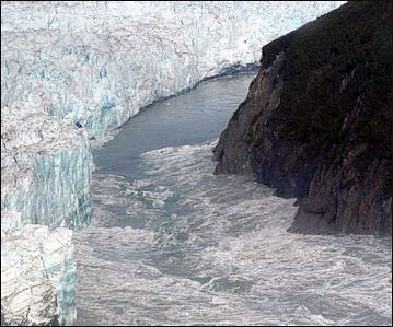
Hubbard Glacier, August 14 2002 Grimsvötn, together with Mardarbunga and Kverkfjöll, lie beneath the vast Vatnajökull icecap in east-central Iceland. Due to its subglacial setting and remoteness, the geology of Grimsvötn is poorly known. The volcano has a composite central caldera, of which the southern rim is the only exposed part of the volcano. Only basaltic material is known to have erupted from Grimsvötn. A large geothermal area in the caldera, with an estimated heat output of 5000 megawatts , continually supplies meltwater to an ice-covered caldera lake. Approximately every 4-10 years the accumulated water is released in glacial outburst floods (jökulhlaups) when the water level is high enough to lift its ice dam. Some jökulhlaups are associated with eruptions. In some instances it can be argued that the extra meltwater generated by a subglacial eruption triggered the draining of the caldera lake (for example, during the 1938 eruption). In other cases the sudden pressure release associated with draining may trigger an eruption. [Source: Newhall and Dzurisin, 1988, Historical Unrest at Large Calderas of the World: U.S. Geological Survey Bulletin 1855]
Because volcanic activity in western Canada was contemporaneous with the ebb and flow of Cordilleran glaciations, many of the volcanoes display ice contact features. Mount Garibaldi itself is a supraglacial volcano which erupted onto a regional ice sheet. Others, such as Hoodoo Mountain, were contained within basins thawed in the ice and assumed the flat-topped form of tuyas. Still others, such as the subglacial mounds of the Clearwater Field, were erupted under glacial ice to form piles of pillow lava and hyaloclastite.
Jökulhlaups (Glacial Lake Outburst Floods)
Jökulhlaups (glacial lake outburst floods) are sudden outbursts of water released by a glacier.The water may be released from glacier cavities, sub-glacial lakes, and from glacier-dammed lakes in side valleys. Jökulhlaups (an Icelandic word pronounced yo-KOOL-lahp) occur when a lake fed by glacial meltwater breaches its dam and drains catastrophically. These lakes can take a number of forms: 1) Ice dammed lakes that are held in by the glacier ice itself; 2) Moraine, rock, or sediment dammed lakes; 3) Lakes that form beneath glaciers. [Source: U.S. National Park Service]
Glacial outburst flood water may be released from glacier cavities, sub-glacial lakes, and from glacier-dammed lakes in side valleys. A sudden release of melt water from a glacier or glacier-dammed lake sometimes resulting in a catastrophic flood, formed by melting of a channel or by subglacial volcanic activity. The smallest, but most frequent, debris flows often begin as glacial outburst floods. Outburst floods become debris flows by incorporating large quantities of sediment from valley floors and walls, often by triggering landslides that mix with the flood waters. The transformation from water flood to debris flow occurs in areas where streams have eroded glacially derived sediments and sediment-rich, stagnant glacier ice that was stranded in valleys as
In order for a jökulhlaup to occur, the lake water levels must reach a critical point such that the lake: 1) causes its ice dam to float; 2) overtops its dam, causing rapid incision into the sediment, rock, or ice that contains it; 3) carves large meltwater channels beneath the glacier ice that allow for rapid drainage. Jökulhlaups may occur with a somewhat regular periodicity, but others drain without warning.
In the worst case scenario a lake fills up with a huge volume of water and much of this water is released when the bank or dam holding the water back suddenly bursts, releasing the huge amount of water. Villages more than a 100 kilometers downstream can be washed away,. The problem is particularly acute with glacial lakes created by moraine walls that are vulnerable to breaking up.
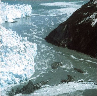
Hubbard Glacier, May 20 2000Daniel Vuichard and Marcus Zimmermann of the University of Bern wrote: Such flash-floods must be anticipated in heavily glacierized mountain regions. They are of several kinds: (1) the catastrophic outbreak of lakes dammed by a glacier, or the outbreak of ponded melt-water from beneath or within a glacier system; (2) the overspill of lakes frontal to a glacier that have been dammed by old end moraines; and (3) the sudden drainage of ephemeral lakes dammed by landslides, rockfalls, or by snow or ice avalanches, that have blocked the main channel of a river. The results of these phenomena range in magnitude all the way from relatively minor flood crests comparable to normal river flood surges induced by heavy rains to catastrophic events several orders of magnitude greater. The drainage of various types of ice-dammed lakes may be periodic, even annual. [Source: “The Langmoche Flash-Flood, Khumbu Himal, Nepal” by Daniel Vuichard and Marcus Zimmermann, Mountain Research and Development, Vol. 6, No. 1 (Feb., 1986), pp. 90-94, Published by: International Mountain Society]
“They are well known in Iceland where they are called "jökulhlaup" (glacier leap), a name which is now widely applied. They have been studied in many glacierized mountain ranges, including the European Alps, Norway, the Yukon, Alaska, and the Andes. They are occasionally associated with volcanic eruptions, in which case devastating debris flows and mudflows may occur in addition to floods. One of the most devastating events of this kind involved an earthquake-induced avalanche from Huascarain in the Peruvian Andes in 1970. This destroyed the town of Yungay and killed 18,000 people. The much more recent (13 November 1985) disaster in the Colombian Andes was the result of volcanic-induced ice and snow melt on Nevado del Ruiz. Flash-floods due to the collapse of glacial moraine dams or landslide dams tend to be nonrecurring, although in high mountain regions the potential for future damming due to slope instability is relatively high.”
There are worries that quick glacial melting caused by global warming could cause dozens of lake to fill up and overflow their banks and produce floods that could kill thousands of people. One study found that water level rises have produced 20 dangerous glacial lakes in Nepal and 24 in Bhutan. Some villages are so worried about this kind of disaster that they have installed warning system with horns to raise the alarm so people at least have enough time to get to higher ground.
For information on Volcanic Glacial Bursts at Vatnajökull Glacier in Iceland see Separate Article DESTRUCTIVE ERUPTIONS: LAHARS, PYROCLASTIC FLOWS AND GLACIAL BURSTS factsanddetails.com
Causes of Jökulhlaups
Rockfalls occur on unstable slopes high upon the mountain and in valleys near glacier termini. Sometimes the rising dust of rockfalls startles local residents by mimicking steam vents and volcanic eruptions. Glaciers undercut headwalls and valley walls, making slopes steep and unstable. Some moraines and debris-covered slopes have cores of slowly melting ice. Rocks often tumble from these unstable slopes.
Some smaller lahars may be triggered by the sudden release of water from cavities within or beneath the ice. We call these events glacial outburst floods, or jökulhlaups (an Icelandic term pronounced Yo-kul-hloips). They have occurred an numerous glaciers on the mountain (Mount Rainier). Jökulhlaups often become lahars when they incorporate the rock debris that lies within their path.
Because outburst floods are unpredictable, you should be alert when visiting valleys with glacier-fed streams, particularly on unusually hot or rainy days. If you are near a stream and hear a roaring sound coming from upvalley, or note a rapid rise in water level, move quickly up the stream embankment, away from the stream channel and to higher ground. Do not try to escape by moving downstream; debris flows move faster than you can run.
Non-magmatic debris avalanches are especially dangerous, because they can occur spontaneously, without any warning. Earthquakes, steam explosions, and intense rainstorms can trigger debris avalanches from parts of a volcano that have already been weakened by glacial erosion or hydrothermal activity.
Debris avalanches commonly contain enough water or incorporate enough water, snow, or ice to transform into debris flows. Debris flows are slurries of water and sediment (60 percent or more by volume) that look and behave much like flowing concrete. During the past 10,000 years, at least 60 debris flows of various sizes have moved down valleys that head at Mount Rainier. All these can be grouped into two categories, called cohesive and non-cohesive debris flows. Cohesive debris flows form when debris avalanches originate from water-rich, hydrothermally altered parts of the volcano. They are cohesive because they contain relatively large amounts of clay derived from chemically altered rocks. Non-cohesive debris flows, in contrast, contain relatively little clay. Mount Rainier's non-cohesive debris flows are triggered whenever water mixes with loose rock debris, such as the mixing of pyroclastic flows or pyroclastic surges with snow or ice; relatively small debris avalanches; unusually heavy rain; or abrupt release of water stored within glaciers.
Melting Glaciers
By some estimates in the past 50 years 82 percent of the Tibetan plateau’s glacier ice has melted. The plateau has lost 10 percent if its permafrost layer in the past decade.
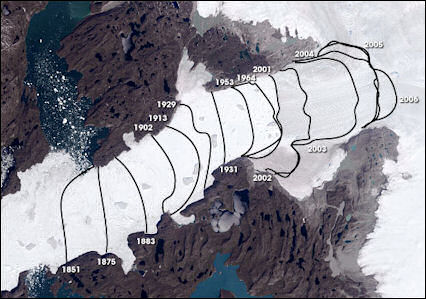
Jakobshavn retreat-1851-2006
Himalayan glaciers are melting at an alarming rate. More than 15,000 glaciers in the Himalayas show evidence of shrinkage, some of it quite dramatic. Many are shrinking at a rates of 70 meters to a 100 meters a year. Some 2,000 Himalayan glaciers have disappeared since 1900. Fifteen-mile-long glaciers have lost a third of their length in the last 50 years. Many scientists think the retreat is linked to global warming.
The shrinkage of Himalayan glaciers could result in water shortages that could affect more than 1 billion people, mainly people that rely on the Indus, Ganges, Brahmaputra, Mekong, Yellow, Yangtze and Salween rivers and their tributaries, which are fed by melt waters from Himalayan and Tibetan glaciers and snow.
According to a report by the WWF glacial melting is expected to increase even more. Initially the result will be flooding but this will be followed by a long steady decline of river flow that could have severe consequences on agriculture and fisheries.
One hydrologist told the Independent, "Glaciers tend to melt out in the summer and that is the time when a great deal of water is needed for agriculture. So it's precisely the time when water is most needed those glaciers give their water. And the threat is that in the future there won't be that water to use."
The melting glaciers have caused the levels of lakes to rise. The levels of 117 lakes in Nagqu prefecture have risen, The water level of Tibet’s second largest lake, Sering Ko, has rise 20 centimeters and grown to a size of 1,620 square kilometers. Since 1997, it has extended five kilometers to the west, 23 kilometers to the southwest, 3 kilometers to the south and 18 kilometers to the north. Rising water levels has submerged 106,667 hectares of pastureland and forced 1,400 household to build new homes.
Scientist are study the phenomena with satellites and trying to restore degraded grasslands.
Glaciers, Climate and Volcanoes
Among the more prominent theories of events that have triggered global climatic changes and lead to repeated glaciation are: (1) known astronomical variations in the orbital elements of the Earth (the so-called Milankovitch theory); (2) changes in energy output from the Sun; and (3) increases in volcanism that could have thrown more airborne volcanic material into the stratosphere, thereby creating a dust veil and lowered temperatures.
The years 1980, 1981, and 1982, for example, saw several major volcanic eruptions adding large quantities of particulate volcanic material and volatiles to the stratosphere, including the catastrophic eruption of Mount St. Helens, Washington, on May 18, 1980, and a large eruption of Mount Hekla, Iceland, on August 17, 1980. The 1982 series of eruptions from El Chichón volcano, Mexico, caused death and destruction in the populated area around the volcano, but a further reaching impact may result from the effect on Earth's climate because of the enormous ejection of volcanic material into the stratosphere.
The potential climatic effect of the Laki volcanic eruption in Iceland in 1783, the largest effusive (lava) volcanic eruption in historic time, was noted by the diplomat-scientist Benjamin Franklin in 1784, during one of his many sojourns in Paris. Franklin concluded that the introduction of large quantities of volcanic particles into the Earth's upper atmosphere could cause a reduction in surface temperature, because the particles would lessen the amount of solar energy reaching the Earth's surface. The catastrophic eruption of the Tambora volcano, Indonesia, in 1815 was followed by a so-called "year-without-a-summer." In New England, for example, frost occurred during each of the summer months in 1816.
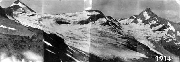
Jackson and Blackfoot Glaciers in 1914
Glaciers and Global Warming
Worldwide glaciers are shrinking. Many blame global warming, which seems to be causing more snowfall in the winter but more melting in the summer. Many glaciers are melting rapidly with the pace having picked up in the last decade. Glaciers have almost vanished from Africa and Papua New Guinea
In the Caucasus half of all glaciers have disappeared in the last 100 years. Mt. Kilimanjaro’s ice cap has shrunk by half in the last 40 years and by 80 percent in the last 100 years. By some estimates it could be ice free in as little as 15 years. Glaciers in the some parts of the Alps and the Andes are shrinking at an alarming rate and some worry they could disappear in the coming decade.
In the 1980s and 1990s glaciers in the Alps have been melting faster but ice covers in Scandinavia, Greenland, Iceland and New Zealand have been growing. In 2008, a total of 70 Swiss glaciers were retreating and five were advancing according to the Swiss Glacier Monitoring network. The Aletsch glacier, the largest in the Alps and a major water source for the Rhine, has been retreating for about 150 years yet it still holds 27 million tons of ice, enough to fill 12 million Olympic-size swimming pools.
Run off from melting glaciers and ice caps is raising sea levels by 1.2 centimeters a year. Estimates vary but glacier and mountain caps could contribute 70 centimeters to global sea levels if they were all to melt. The melting of glaciers isn’t necessarily tied to global warming. Scientists say it can take decades for a glacier to respond to warming and that melting is occurring is still partly the warming after the Little Age from 1450 to 1890.
See Separate Article MOUNTAIN GLACIERS AND GLOBAL WARMING factsanddetails.com TIBET, THE HIMALAYAS, MELTING GLACIERS AND GLOBAL WARMING factsanddetails.com

Jackson and Blackfoot Glaciers in 2001
Studying Glaciers
Scientists studying glaciers examine snowfall records and stream flow data; drag ground -penetrating radar over crevasses; analyze soil carbon; and check in animals that live around glaciers. Studying the size and movement of glaciers in the past is difficult because as glaciers move they act like giant erasers, obliterating almost all traces of what happened before. Sometimes the most accurate way to analyze the size of glaciers in the past is to observe old paintings and photographs.
In northern Norway, scientists build temporary caves into the middle of glaciers to study the internal mechanism of glaciers. The caves are dug with warm-water jets. They begin shrinking almost as soon as they are dug and usually collapse within a couple of days. Among the things that scientists have discovered is that bottom of glaciers are filled with water pockets; and friction between sediments in the glacier and rock face is 20 times great than mathematical models predicted.
Scientists in Greenland are drilling deep into continental glaciers there to study climate change, air pollution and other things. The cores reach air pockets and ice that has been trapped for more than 100,000 years. Among the things that scientists have found are ash from the Krakatau explosion, lead pollution from ancient Rome, dust blown from Mongolia and signs that global warming is linked to human intervention.
Scientists study glacier movement dating organic objects found in them such as pieces of wood and plants and analyzing rocks found in deep sediment cores. Scientists are gaining insights into a number of fields by collecting objects that have been revealed as glaciers melts. The Iceman found in 1991 Europe is the most spectacular example of this. Frozen mummies have been found in Peru. Animals of various kinds have been found in glaciers all over the world.
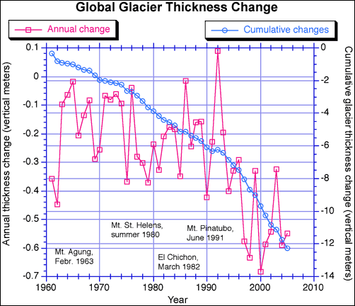
Glacier thickness
Studying glaciers is often labor-intensive and time consuming. Hundreds of bamboo stakes and poles — often seven meters long — are stuck into the glacier. After a year or so the stakes are checked. The stakes at higher elevations will have snow piled around them and scientists can estimate the amount of snowfall there. The stakes at lower elevations reveal snow melt evaporation. Veteran glaciologist Ian Allison told Reuters, “So you can measure how much height is lowered down below, how much it gained at the top, you’ll need to know the density of the snow and ice as well.”
The process is often hard work. Often the glaciers are hard to reach and the equipment has to be carried in on foot or the backs of horses, mule or yaks. On top of that, especially in the Himalayas, many glaciers are in politically sensitive areas near the borders of India, China, Pakistan or Central Asia . In these places satellite phones and GPS devices are often banned.
Scientists studying glaciers and global warming sometimes carry carbon sensors, sensitive GPS systems and state-of-art, solar-powered weather stations with them on the backs of their pack animals. The teams are not all that different than those used by pioneering mountain surveyors and the first mountaineers to scale the major Himalayan peaks.
Lack of information is a serious problem. Only about 100 glaciers globally are monitored with regular “mass-balance” measurements that reflect how much glaciers grow and retreat from one year to the next. Allison told Reuters, “We probably know less about the total volume of glaciers than we do about the big ice sheets in Greenland and Antarctica because a lot of it is in small mass areas and a lot of it is inaccessible. Most of the ones that are observed are monitored by the Switzerland-based World Glacier Monitoring Service.
The most carefully studied glaciers are in the Alps. Improved satellite imagery and airborne photography and global positioning is making studying remote glaciers easier.
Glacier-Related Terminology
Ablation refers to all processes by which snow, ice, or water in any form are lost from a glacier. Ablation is the loss of snow or ice by evaporation and melting. The rate at which ablation occurs depends on the atmospheric conditions present, such as air moisture content, solar radiation, temperature, and the reflectivity (Albedo) of the snow or ice surface. Fresh snow has a high albedo (0.7 to 0.9), indicating that 70 to 90 percent of the radiation received is reflected; glacier ice has a lower albedo of 0.2 to 0.4. Therefore, more radiation may be absorbed by glacier ice than by snow. Glaciers around the mountain receive different amounts of sunlight, so each glacier has its own characteristic ablation pattern. A Visitor's Guide to Mount Rainier Glaciers, written by USGS Glaciologist Carolyn Driedger (published in 1986 by the Pacific Northwest National Parks and Forests Association).
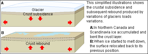
Glacier weight effects
Ablation area: is the lower region of a glacier where snow ablation exceeds snowfall. A line that marks the limit on a mountain above which snow persists from one winter to the next is called the annual snowline, and this line on a glacier is called the firnline. Above the firnline, snow that falls each year packs down and changes into glacier ice as air is slowly forced out of it. This part of the glacier is its accumulation area where more snow falls each year than is lost by melting. Below the firnline is the ablation area, where melting predominates.
Accumulation area is the upper region of a glacier where snow accumulation exceeds melting. A line that marks the limit on a mountain above which snow persists from one winter to the next is called the annual snowline, and this line on a glacier is called the firnline. Above the firnline, snow that falls each year packs down and changes into glacier ice as air is slowly forced out of it. This part of the glacier is its accumulation area where more snow falls each year than is lost by melting. Below the firnline is the ablation area, where melting predominates.
Albedo is the percentage of the incoming radiation that is reflected off a surface. An albedo of one indicates that 100 percent of the radiation is reflected. Fresh snow has a high albedo (0.7 to 0.9), indicating that 70 to 90 percent of the radiation received is reflected; glacier ice has a lower albedo of 0.2 to 0.4. Therefore, more radiation may be absorbed by glacier ice than by snow.
Density is the ratio of the mass of an object to its volume. Snow has a density averaging about 0.1, firn has a density greater than 0.55, and glacier ice has a density of about 0.89. The density of unmineralized fresh water is 1. Glaciologists measure snowpack density frequently so that they may anticipate future water supplies, and to assess avalanche hazards. The density of a fresh snowpack is about 0.1; firn has a density of about 0.55 and glacier ice, of about 0.89. Each annual snow layer has a characteristic grain size and density.
Equilibrium line is the boundary between the accumulation area and the ablation area.
Hydrothermal alteration is the alteration of rocks or minerals due to the reactions of geothermally heated water with minerals. The process weathers and weakens the rocks such that they may become unstable.
Kinematic waves refer to a wave of ice moving downglacier propagated by its increased thickness. The wave of ice may move at two to six times the velocity of surrounding thinner ice.
Mass balance describes the net gain or loss of snow and ice through a given year. It is usually expressed in terms of water gain or loss.
Neoglaciation: Neoglaciation refers to the advances made by mountain glaciers since the great Pleistocene ice age. In the Cascades the advances have occurred since 6,600 years before present.
Perfectly plastic solid: A solid that does not deform until it reaches a critical value of stress, after which it will yield infinitely. Some glaciologists say that ice is a perfectly plastic substance. That is, brittle and capable of cracking like a solid, yet deformable and capable of flowing at other stresses.
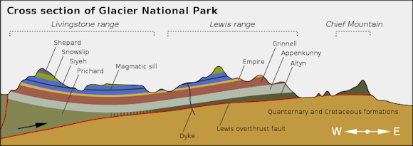
Glacier National Park cross section
Suncup: A suncup is a small depression on a snow or firn surface formed by melting and evaporation resulting from direct exposure to the sun. A short-lived, frequently large-scale, increase in the rate of movement of the ice within a glacier. Ice velocities may increase 10 to 100 times above normal flow rates. In some surges, the terminus of a glacier rapidly advances. Although not all glaciers surge, those that do often surge with some sort of a periodicity.
Trimlines are the sharp vegetative boundaries delimiting the upper margin of a former glaciation. The age differences of the ground surface are often visible because of different ages of the vegetation.
Image Sources: Wikimedia Commons, United States Geological Survey (USGS), NASA, Purdue University
Text Sources: United States Geological Survey (USGS), U.S. National Park Service, New York Times, Washington Post, Los Angeles Times, Times of London, Yomiuri Shimbun, The Guardian, National Geographic, The New Yorker, Time, Newsweek, Reuters, AP, Lonely Planet Guides, Compton’s Encyclopedia and various books and other publications.
Last updated April 2022
