TSUNAMIS
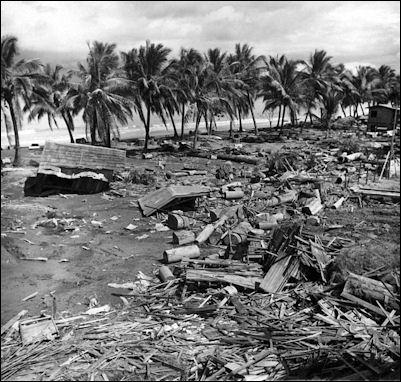
1976 Lebak Tsunami in the Philippines
killed 8000 people A tsunami is a series of waves produced by an event in the ocean such as an underwater landslide or an earthquake that cases large amounts of seawater to be displaced . Sometimes they can be very large. Catastrophic ones occur a few times a century, Other times they are so small they virtually undetectable. The word tsunami is derived from the Japanese “tsu” (“harbor”) and “nami” (“waves”).
Out in the depths of the ocean, tsunami waves do not dramatically increase in height. But as the waves travel inland, they build up to higher and higher heights as the depth of the ocean decreases. The speed of tsunami waves depends on ocean depth rather than the distance from the source of the wave. Tsunami waves may travel as fast as jet planes over deep waters, only slowing down when reaching shallow waters. While tsunamis are often referred to as tidal waves, this name is discouraged by oceanographers because tides have little to do with these giant waves. A tidal wave according to Oxford English Dictionary is a “high water wave caused by the movement of the tide.” It is different from a storm surge a flood of water that occur when water pushed inland by a storm such as a typhoon coincides with a high tide. [Source: NOAA]
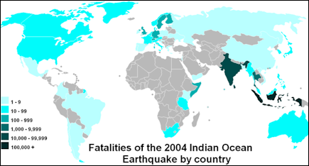
About 85 percent are tsunami are produced in the Pacific Ocean. Most are generated in the Pacific rim because more undersea earthquakes are generated there than anywhere else. More than 800 tsunamis have been generated in the Pacific in the last century. Some 22 percent of these were generated off of Japan. Between 1992 and late 2004 there were 17 major tsunamis, with 11 of them in the Pacific. They killed a total of 4,000 people. Tsunamis occur much less frequently in the Atlantic Ocean and Indian Ocean. But they do occur there. One in 1945 killed several hundred people in Bombay. Another in 1762 ravaged a large part of what is now Bangladesh and other parts of the Bay of Bengal. The 2004 tsunami that killed 225,000 people was in the Indian Ocean.
Good Websites and Sources: Wikipedia article on Tsunamis Wikipedia ; Surviving a Tsunami, Lessons from Chile, Hawaii and Japan pubs.usgs.gov ; Tsunami Warning System in Japan jma.go.jp/jma ; Tsunami Warnings from Japan Meteorological Agency jma.go.jp/en/tsunami ; Book: “Tsunami: The Underrated Hazard” by Edward Bryant. Tsunamis That Struck Japan Major Tsunamis in Japan in the 20th Century tsunami.civil.tohoku.ac.jp ; Major Earthquakes and Tsunamis in Japan in the 20th Century drgeorgepc.com ; 1933 Earthquake and Tsunami pdf file cidbimena.desastres.hn ; 1983 Tsunami drgeorgepc.com ; Report on the 1993 Tsunami nctr.pmel.noaa.gov ; Small Tsunami in 2010 reuters.com ;
See Separate Articles: DECEMBER 2004 TSUNAMI IN INDONESIA, SOUTHEAST ASIA AND SOUTH ASIA factsanddetails.com ; MARCH 2011 EARTHQUAKE AND TSUNAMI IN JAPAN factsanddetails.com ; TSUNAMIS PREPAREDNESS IN JAPAN factsanddetails.com ; LARGE TSUNAMIS IN JAPAN factsanddetails.com
Tsunami Dynamics
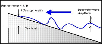
physics of tsunami wave
as it approaches a shoreMost tsunamis are comprised of a series of crests and troughs called a “wave train" — and have a leading wave followed by crests that push it from behind. Damages is not caused so much by huge wall of water crashing down like a large beach wave but rather by a surge of water than pushes far inland. The waves comes in series, sometimes with many minutes passing from one to the next. Waves a meter high can severely damage houses. A two-meter-high tsunami can destroy wooden buildings. Often the damage caused by receding waves being sucked to the sea is more severe than that caused by advancing waves. Receding waves can also drag people far out to sea.
The height of a wave can differ significantly depending on the contour of the land areas that are stricken. A narrow creek can funnel such waves, causing them to rise to a height of 10 meters. If the earthquake that generates the waves is nearby the waves come in rapid succession. If the earthquake is farther away the waves can arrive over a period of several hours.
Robert Stewart wrote in the “Introduction to Physical Oceanography”:The sudden motion of sea floor over distances of a hundred or more kilometers generates waves with periods of 15–40 minutes. A quick calculation shows that such waves must be shallow-water waves, propagating at a speed of 650 kilometers per hour (400 mph, 180 meters per second) and having a wavelength of 130 kilometers in water 3.6 kilometers deep. The waves are not noticeable at sea, but after slowing on approach to the coast, and after refraction by sub-sea features, they can come ashore and surge to heights ten or more meters above sea level. In an extreme example, the great 2004 Indian Ocean tsunami destroyed hundreds of villages, killing at least 200,000 people. [Source: Robert Stewart, “Introduction to Physical Oceanography”, Texas A&M University, 2008]
In the early 1960s, Shepard summarized the influence of tsunamis based on his studies in the Pacific. 1) Tsunamis appear to be produced by movement (an earthquake) along a linear fault. 2) Tsunamis can travel thousands of kilometers and still do serious damage. 3) The first wave of a tsunami is not likely to be the biggest. 4) Wave amplitudes are relatively large shoreward of submarine ridges. They are relatively low shoreward of submarine valleys, provided the features extend into deep water. 5) Wave amplitudes are decreased by the presence of coral reefs bordering the coast. 6) Some bays have a funneling effect, but long estuaries attenuate waves. 7) Waves can bend around circular islands without great loss of energy, but they are considerably smaller on the backsides of elongated, angular islands. [Source: Robert Stewart, “Introduction to Physical Oceanography”, Texas A&M University, 2008]
Physics of Tsunamis
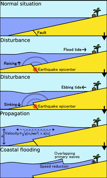
Tsunamis are caused when there is a movement of land on the ocean floor and this displaces water causing one area of water to be higher than an other. The water at the surface starts to shift downhill and that is what triggers the tsunami. Tsunamis tend to maintain their force as they travel through the deep seas at speeds of a jetliner. While normal waves are movements of water along the surface of the sea tsunamis are forces that move through the sea sort of like a series of dominoes knocking over the dominoes in front of it. When a tsunami strikes a shallow ocean bottom it loses some energy to friction. In the open sea there is nothing to slow it down.
Tsunami waves usually strike in a train of a dozen or more waves rather than a single wave with each wave slightly weaker that the one in front of it. The distance between the swells can be a be a kilometer or more.
Tsunamis waves generally radiate out in directions opposite from the seismic disturbance. They are distinguished from coastal waves in that can be very long and move at very high speeds. A single wave from a tsunami can be 160 kilometers long and move across the ocean at 965 kilometers per hour.
Tsunamis move like sound waves through the water and get slower and more powerful at the surface as they move through shallow water. When they approach the coast the slow dramatically as their wavelength shortens, causing them to rise up dramatically because of the enormous volume of water that piles up in the shallow water. The top travels at fast speed which increases its height.
A super powerful tsunami can move at 900kph in deep water, producing only a ripple at the surface, not even noticed by ships in the open sea. It slows to 300kph at the continental shelf and then suddenly rises to 20 meters when it hits the shore at 35 kph, potentially killing thousands. When a wave slows it does not lose energy it simply rearranges it. In many case the full energy of a tsunami is not released until it hits something.
When the water off the coast is very deep, tsunamis come a shore like a high tide that just keeps coming and coming. When the water is shallow large violent, breaking waves are more likely. When trains of waves hit shallow water the leading waves slows down first and the waves behind them slow down less rapidly and pile on from behind, shortened the distance between the waves and adding to the height of the leading waves. Hours after an earthquake tsunamis loose energy because of friction over the rough sea bottom and/or the dissipation of energy over long distances.
Causes of Tsunamis
Tsunamis can be caused by earthquakes, earthquake-induced landslides, non-earthquake landslides caused by water from aquifers, volcanic eruptions, and collapsing sea cliffs and explosions on volcanic islands, volcanic eruptions or meteor or asteroid impacts. The most common and destructive tsunamis are caused by earthquakes.
Landslides caused by earthquakes, rock falls or ice falls can produce enormous local tsunamis. Places that are vulnerable to these events include the unstable flanks of volcanos and continental shelves with huge deposit of sediments. Some of the largest tsunamis have been generated by earthquake-induced landslides. These can occur after any large earthquake, say 6.5 on the Richter scale and above. An earthquake in Lutuya Bay, Alaska in 1958 caused a massive rock fall that generated a tsunami that was 1,720 feet high, 267 feet higher than the Empire State Building. Fortunately it struck a wilderness area and did not travel across the sea to Japan or Hawaii.
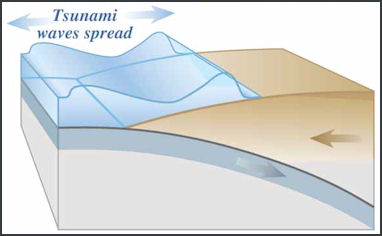
Volcanic eruptions, the collapse of volcanic features and huge profusions of ash are all capable of producing a tsunami. The volcanic explosion of Krakatau in Indonesia and the collapse of its caldera produced 130-foot-high waves and killed 36,0000 people. There are concerns about specific volcanos triggering huge landslides that could generate tsunamis over 1000 feet high. The collapse of Mauna Loa volcano in Hawaii produced an tsunami that was between 335 and 490 meters (1,100 and 1,600 feet). The size of the tsunami was gaged in part on pieces of coral found on mountain tops in Hawaii.
An asteroid three of four miles in diameter crashing into the Atlantic Ocean could produce a tsunami large enough to wash over New York City and climb up the Appalachian mountains. A 53-mile-wide asteroid that landed in Chesapeake 35 million years is believed to have produced waves that were thousands of feet high. One that landed on land 65 million years is believed to have kicked up enough debris to cause the climate to change and the dinosaurs to become extinct.
Subduction Earthquake Tsunamis
Destructive tsunamis are typically caused by devastating subduction earthquakes. They're the the most powerful earthquakes on the planet, and they occur at plate boundaries, where one tectonic plate is grinding unceasingly beneath another. When the bottom plate suddenly lurches deeper, a huge amount of energy is released, unleashing the sorts of massive earthquakes and calamitous tsunamis that hit the Indian Ocean in 2004 and the coast of Japan in March 2011. Generally an earthquake of 7.5 of larger is needed to deform the sea bottom enough to displace enough water to produce tsunamis wave pulses that can travel long distances across the ocean. These earthquakes typically occur along thrust faults, where an ocean plate is thrust under a continental plate, dragging it down until the fault ruptures, causing an earthquake that cause the sea floor to rise.
Subduction faults, angled at 10 to 15 degrees from horozontal, are significantly different from vertical faults sich as the San Abdreas fault in California. With a subduction fault you get a much larger locked area, so the quake can be much bigger. Vertical fault quakes tend to peak at roughly magnitude 8 while subduction quakes can be in the 9s as was the case with the quakes that spawned the 2004 tsunami in Sumatra and the Indian Ocean and the March 2011 earthquake and tsunami in Japan. .Between 8 and 9 is a factor of 30 in energy.
Life of a Tsunami
Tsunami Generation: Earthquakes are commonly associated with ground shaking that is a result of elastic waves traveling through the solid earth. However, near the source of submarine earthquakes, the seafloor is "permanently" uplifted and down-dropped, pushing the entire water column up and down. The potential energy that results from pushing water above mean sea level is then transferred to horizontal propagation of the tsunami wave (kinetic energy). For the case shown above, the earthquake rupture occurred at the base of the continental slope in relatively deep water. Situations can also arise where the earthquake rupture occurs beneath the continental shelf in much shallower water. [Source: USGS]
Tsunami Wave Split: Within several minutes of the earthquake, the initial tsunami is split into a tsunami that travels out to the deep ocean (distant tsunami) and another tsunami that travels towards the nearby coast (local tsunami). The height above mean sea level of the two oppositely traveling tsunamis is approximately half that of the original tsunami. (This is somewhat modified in three dimensions, but the same idea holds.) The speed at which both tsunamis travel varies as the square root of the water depth. Therefore, the deep-ocean tsunami travels faster than the local tsunami near shore.
Amplification: Several things happen as the local tsunami travels over the continental slope. Most obvious is that the amplitude increases. In addition, the wavelength decreases. This results in steepening of the leading wave--an important control of wave runup at the coast (next panel). Note that the first part of the wave reaching the local shore is a trough, which will appear as the sea receeding far from shore. This is a common natural warning sign for tsunamis. Note also that the deep ocean tsunami has traveled much farther than the local tsunami because of the higher propagation speed. As the deep ocean tsunami approaches a distant shore, amplification and shortening of the wave will occur, just as with the local tsunami shown above.
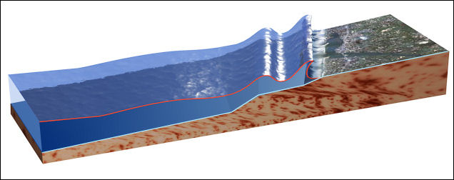
tsunami dynamics
Tsunami Runup: Tsunami runup occurs when a peak in the tsunami wave travels from the near-shore region onto shore. Runup is a measurement of the height of the water onshore observed above a reference sea level. Except for the largest tsunamis, such as the 2004 Indian Ocean event, most tsunamis do not result in giant breaking waves (like normal surf waves at the beach that curl over as they approach shore). Rather, they come in much like very strong and fast-moving tides (i.e., strong surges and rapid changes in sea level). Much of the damage inflicted by tsunamis is caused by strong currents and floating debris. The small number of tsunamis that do break often form vertical walls of turbulent water called bores. Tsunamis will often travel much farther inland than normal waves.
Do tsunamis stop once on land? No! After runup, part of the tsunami energy is reflected back to the open ocean and scattered by sharp variations in the coastline. In addition, a tsunami can generate a particular type of coastal trapped wave called edge waves that travel back-and forth, parallel to shore. These effects result in many arrivals of the tsunami at a particular point on the coast rather than a single wave as suggested by Panel 3. Because of the complicated behavior of tsunami waves near the coast, the first runup of a tsunami is often not the largest, emphasizing the importance of not returning to a beach many hours after a tsunami first hits.
Power of a Tsunami and Tsunami Water
According to the New York Times, “The power of a tsunami comes from straightforward physics. An earthquake suddenly pushes part of the sea floor up or down. That changes the height of the water above it — what physicists call potential energy — and the potential energy quickly changes into the kinetic energy of the tsunami waves.” [Source: New York Times
“In addition to the damage that a tsunami can inflict along coastlines in particular countries, it can also have an effect on the entire earth. The planet’s oceans are very heavy, applying enormous pressure to the ocean crust. When the distribution of that pressure is shifted, as it is during an earthquake, it can induce wobbles in the earth’s rotation.” [Ibid]
“It takes a lot of force just to keep water in place. More than three million cubic yards of concrete hold back the water behind Hoover Dam on the Nevada-Arizona border. At its base, the pressure of the water reaches 45,000 pounds per square foot. In that case, however, the enormous power of water is put to positive use: to generate electricity.”
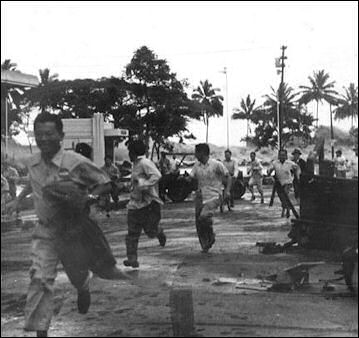
Hawaii 1946On the force of the water generated by tsunamis the New York Times reported: “A typical bathtub holds 40 gallons or so of water. That is 330 pounds. A cubic yard of it, filling what at first glance seems a modest volume of 3 feet by 3 feet by 3 feet, weighs nearly 1,700 pounds, as much as the Smart micro car. And when water is moving at 30 or 40 miles an hour, like the tsunami that inundated northern Japan on Friday, the heaviness of water turns deadly. Imagine 1,700 pounds hitting you at that speed, and each cubic yard of water as another 1,700 pounds bearing down on you. The destructiveness of a tsunami is not just one runaway car, but a fleet of them. [Source: New York Times]
“That’s exactly the analogy to use,” Philip N. Froelich, a professor of oceanography at Florida State University, told the New York Times. “And by the time you’re talking about a wall of water that’s 10 meters high, if that wave is two miles long into the ocean, it’s basically like a hundred tanks coming across you. Even though it’s a fluid, it operates like a solid hammer.”
“Water does not act quite the same way as speeding cars,” the New York Times reported. “As a fluid, it can slip around some objects like round columns, while slamming full force when a large wall is in its way. It also gathers debris — dirt, cars, trees — as it flows. Those added projectiles can create more destruction as they crash into other objects. Even if the wave only comes up to the knees, the force is enough to knock a person down.”
Dangerous Tsunamis
It is difficult to predict the likelihood of a dangerous tsunami simply on the magnitude of earthquake. A lot of factors come into play: the kind of earth quake, where on the ocean floor it occurs, the depth of water, the distance from coastal areas, the configurations of harbors and bays and the topography of the land where a tsunami comes a shore.
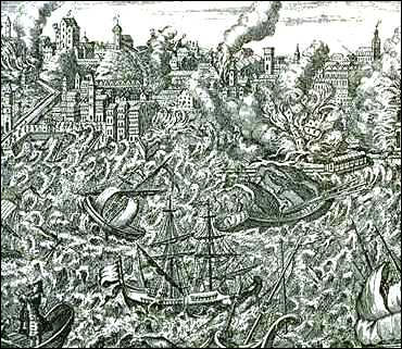
1755 Lisbon earthquake and tsunami A dangerous tsunami is more likely to develop in deep water than in shallow water. It is also more likely to develop if the movement of earth is large but concentrated in an small area rather than spread out over a large area. Destructive tsunami often occur where the water is channeled either in the sea or by land and focused on one area.
Generally an earthquake of a magnitude of more than 8.5 on the Richter scale is necessary to produce tsunamis that affect areas long distances away from the epicenter of an earthquake. Smaller earthquakes can generate powerful local tsunamis. But even large earthquakes do not necessarily produce large tsunamis. The worst tsunamis often occur when there is a huge vertical movement on ocean floor, causing sudden, large displacement of water. This contrasts to dangerous land earthquake which often have violent horizontal movements that cause violent shacking over a large area.
Obviously tsunamis are most dangerous when they hit places with a lot of people. Hotels and houses are built along beaches and harbors are particularly vulnerable. Coral reefs, marshes, forests and mangroves act as natural buffers. When they are removed or disturbed they remove obstacles that can slow a tsunami down.
Tsunami Detection and Measurements
Tsunami detection is very difficult. Scientists use seismometers, sensitive devices used to detect earth movements and measuring earthquakes; tide gauges, that measure changes in the water surface level; and wave-sensing buoys. Water level gauges cost between $5,000 and $20,000 depending on the sensitivity the instruments and the quickness of their communication ability.
The most effective technology are deep ocean instruments called tsunameters than detect passing waves and transmit the information to satellites via buoys at the surface. They cost $250,000 a piece and require $50,000 a year for maintenance. As of 2005 there were only seven of them in operation.
In an efforts to create a global tsunami warning system, tsunami detection devices have been placed around the world on ocean floors at depths of up to 5,400 meters. Scientist have extensively mapped the ocean floor with the aim of finding out where potential tsunami-inducing areas are.
Tying the system together is a communication network that can relay data to a central data base and then disseminate the information quickly to places where the tsunamis may strike.
The world’s largest tsunami research center is run by Oregon State University. Composed of a hanger-size building with a 111-meter-long, 90-centimeter-deep wave pool, it is used mainly to study the effect of large tsunamis on buildings and infrastructure in coastal areas. Tests involve crashing waves on models in various landscapes with the goal of helping planners figure out where to place buildings, plan evacuation routes and design buildings and infrastructure.
According to the “Introduction to Physical Oceanography”: Numerical models are used to forecast tsunami heights throughout ocean basins and the inundation of coasts. For example, NOAA’S Center for Tsunami Research has used the Method of Splitting Tsunami most model. The model uses nested grids to resolve the tsunami wavelength, it propagates the wave across ocean basins, and then calculates run-up when the wave comes ashore. It is initialized from a ground deformation model that uses measured earthquake magnitude and location to calculate vertical displacement of the sea floor. The forcing is modified once waves are measured near the earthquake by seafloor observing stations. [Source: Robert Stewart, “Introduction to Physical Oceanography”, Texas A&M University, 2008]
Tsunami Warning
deaths from the 2004 Indonesian tsunamiIf a very low tide occurs after an earthquakes, it means that a tsunami is approaching fast. During a tsunami the waves can keep coming. If you make it to high ground stay there for at least six hours.
Whether you can escape from the ensuing tsunami after feeling an earthquake's jolt is the difference between life and death. Shigeo Takahashi, director of the Asia-Pacific Center for Coastal Disaster Research at the Port and Airport Research Institute, told the Yomiuri Shimbun, “You must 'escape vertically' and, after evacuating, don't leave until your safety is confirmed."
"Even if you run, a high-speed tidal wave will catch up with you at ground level," said Shigeo Takahashi, director of the Asia-Pacific Center for Coastal Disaster Research at the Port and Airport Research Institute. "You should use a car or anything-whatever means available-to escape [as fast as possible] to higher ground. If there is no higher ground nearby, you should go to a strong-looking building or a pedestrian bridge." Such a building should be, at the very least, more than three stories, he added.
A tsunami warning system for the Pacific Ocean has existed for decades. Headquartered in Hawaii, it issues warnings to 26 nations and was set up in 1965 after devastating tsunamis in Chile and Alaska in the early 1960s. The system analyzes earthquake data from several seismic networks. The information is fed into a computer and models predict were tsunamis might form and strike, and predictions and warnings are dispatched to affected areas. As new data comes in the information is updated.
Hawaii is outfit with sirens to warn people of approaching tsunamis.
Traditional Tsunami Warnings
In some parts of the world, tsunami warnings have been passed down through oral traditions. That is the case on Simeulue Island in Indonesia, which was struck by the huge Indian Ocean tsunami on December 26, 2004. Earthquake analysts concluded that longstanding warnings about the importance of running to high ground at the first shaking of an earthquake, dating from the 19th century, played an important role in limiting the death toll to seven out of 80,000 residents.
In Japan, there are tsunami stones set up hundreds of years ago. After the 2011 tsunami, Evan Osnos wrote in The New Yorker: Up and down the battered coast, [residents] rediscovered gnarled stone tabletswhich had been left by ancient ancestors at precise points on the shore to indicate the high-water marks of previous tsunamis. The inscriptions implored future generations never to build closer to the water again. “No matter how many years may pass,” read one, “do not forget this warning.”
The 200 Moken that live on South Surin Island, 65 kilometers off the west coast of Thailand, all survived the Great Tsunami in 2004 but one even though the island was hard hit by the tsunami waves and the flimsy thatched huts that they live in are all located next to sea. They have traditionally called tsunamis “waves that eat people.” Closely in tune with the sea they knew that an earthquake followed by a retreating sea meant only one thing. Salama, a 60-something Moken chief told the New York Times, “I had never seen such as low tide. I started telling people that a wave was coming.” The chief said he that he had been told about such thing by his elders. By the time the wave arrived all the Moken on the island had safely reached high ground. The one man who was killed was elderly and disabled and had accidently been left behind. [Source: Abby Goodnough, New York Times, January 24, 2005]
See Separate Article TSUNAMI PREPAREDNESS IN JAPAN: WARNING SYSTEMS, SEAWALLS AND TSUNAMI STONES factsanddetails.com ; MOKEN: SEA NOMADS OF SOUTHEAST ASIAfactsanddetails.com
st Updated April 2022
Tsunami Warning Systems Often Don't Help Victims
Reporting from the Mentawai Islands in Indonesia, Kristen Gelineau and Tim Sullivan of Associated Press wrote: “Costly warning systems installed across Asia since the deadly 2004 tsunami did nothing to save villagers on these remote Indonesian islands who saw homes and loved ones swept away by a giant wave this week. Such systems can be effective for people living hours away from where a tsunami is forged but are often unable to help those most at risk. [Source: Kristen Gelineau and Tim Sullivan, Associated Press, October 29, 2010]
Officials say a 10-foot (3-meter) wave struck the Mentawai islands just minutes after a massive earthquake offshore, killing more than 400 and destroying hundreds of homes in 20 villages. There are questions about whether Indonesia's system was working properly, but even if it was, a tsunami generated by an earthquake so close to shore can reach land long before there's a chance to raise an effective alert, experts say.
Piatoro, a coconut farmer on the wave-battered island of Pagai Selatan, said he and his family ran out of their house when the quake struck, but there was no warning that a tsunami was coming. They waited a moment, then went back inside. When the water slammed into their home, they tried to run for higher ground but it was too late. His feet were snatched from under him, and he was sucked into the waves, tumbling over and over. His wife was torn from him. "I felt like I was boneless," Piatoro, 49, said Friday as he sat alone on a hospital mat, skin scraped from his calf and stitches on a foot wound. Like many Indonesians, he has only one name. It was not clear if his wife survived.
Tsunami alerts were sounded by scientists within minutes of the earthquake, but some villages have no telephone lines, making it extremely difficult for a warning to get through in time.Renato Solidum, the director of the state-run Philippine Institute of Volcanology and Seismology, said seaside communities needed to learn to read natural signs — such as earthquakes and unnaturally receding seas — and immediately move away from the coast even before alarms go off. But reading those signs can be difficult. For instance, Piatoro and his wife actually ran from their house twice on Monday, once after the initial quake and then again after the first aftershock. But the shaking did not seem bad enough to set off a tsunami.
Indonesian authorities have created a system designed to sound an alarm within five minutes of an earthquake, and have tried to teach people to move quickly uphill. "But obviously that's a tall order — that's not much time to react and it's not much time for the system to work out what's happened," said Chris Ryan, co-director of the Joint Australian Tsunami Warning Center.
Scientists still insist the warning systems are necessary.The 2004 Sumatran tsunami disaster pushed many countries to order advanced alert systems, most of which rely on electronic buoys to detect sudden changes in water levels. The network of systems has cost many millions of dollars — with the most complex buoys sold for $1 million each. Farther from Indonesia, other countries said the new warning systems worked well, and that their response to the quake and tsunami that struck the Mentawai Islands proved that.
"The system that is now in place for the whole Indian Ocean did work, and would have prevented widespread areas being surprised if it had been a more widespread tsunami," said Ryan, from the Australian warning center. "Within 10 minutes of the earthquake, we had issued a bulletin warning that there was potential for a local tsunami," said Satheesh C. Shenoi, director of the Indian National Center for Ocean Information Services.
The system, though, is based on an often inexact science. Earlier this year, a magnitude 8.8-earthquake struck Chile, spawning warnings of a deadly wave heading across the Pacific. Scientists, working from reams of data and complex computer models, warned that "urgent action should be taken to protect lives and property," sending hundreds of thousands of people fleeing for high ground in Hawaii, Japan and elsewhere. Instead, most waves were just a few feet (a meter) high and — except off the Chilean coast — there was little reported damage.
What Are the Best Ways to Avert Tsunami Disasters
Andrew Baird wrote in the New York Times: Since the Indian Ocean tsunami in 2004 “that killed more than 200,000 people, governments, donors and experts have embraced the idea that healthy mangrove forests and coral reefs could reduce the death toll from a giant wave.” However, “research suggests that the level of protection offered by greenbelts has been exaggerated. And by diverting resources from more effective measures like education campaigns and evacuation plans to well-meaning but misguided reforestation, we may even contribute to a greater loss of life in future tsunamis. [Source: Andrew Baird, New York Times, December 26, 2006. Andrew Baird is a postdoctoral fellow at the Center for Coral Reef Biodiversity at James Cook University]
“There have been few scientific studies about the protective role of coastal vegetation. And while one study did suggest that a shield of mangrove forest managed to reduce tsunami damage in three villages in Tamil Nadu State in India, the forest was not the only difference between these coastal villages and those nearby that suffered major destruction. Indeed, when my colleagues and I re-analyzed the data, we found no relationship between the death toll in each village and the area of forest in front of each one.
“What actually saved these villages was being further from the coast or built on relatively high land. It was only a coincidence that they also had more forest between themselves and the ocean (of course, the further a village is from the coast, the greater potential area of forest). Indeed, a recent paper in the journal Natural Hazards that surveyed more than 50 sites in affected regions found that coastal vegetation did not reduce tsunami damage, and that damage was actually greater in areas fronted by coral reefs.
“Similarly, my colleagues and I, working in Aceh, Indonesia, found that neither reefs nor coastal forest reduced the damage caused by the tsunami. The distance the tsunami traveled inland was largely determined by the height of the tsunami and the slope of the land. In other words, where the tsunami was 30 feet high, it flooded all land lower than 30 feet above sea level, whether this reached 200 yards inland, or two miles.
Mangrove forests are, to be fair, very effective at dissipating the energy of storm waves, but a tsunami is a very different beast. Tsunamis, produced by earthquakes, have wavelengths of miles, compared to that of a few yards for typical wind-generated waves. The tsunami, for instance, that hit the Acehnese coast was eight miles thick; this wall of water rolled in for nearly an hour. Of course, coastal forests at some point do begin to reduce tsunami damage, but we can’t expect them to offer meaningful protection against the sheer amount of energy involved in a tsunami.
Another significant concern is the enforcement of buffer zones in the name of tsunami protection. Buffer zones, to have any real effect, would need to be many miles wide and thus impossible to institute without prohibitively high social and economic costs. Perhaps it is unsurprising then that local governments have begun to regulate these barriers in a way that is not only insufficient, but grossly unfair: luxury hotels escape enforcement while tens of thousands of impoverished fishing families in India, Sri Lanka and Thailand are prevented, in the name of tsunami protection, from rebuilding their homes in areas that have been designated buffer zones.
The tsunami on July 17, 2006 demonstrated the tragic consequences of inadequate planning. More than 18 months after the 2004 catastrophe, the Indonesian government had yet to deploy an early warning system on the island of Java. Tremors from a major earthquake were felt and the tsunami was preceded by a telltale withdrawal of the sea — yet amazingly, people did not know to seek high ground. Government officials failed to act despite precise warnings, and more than 600 people died. Clearly, education efforts in Indonesia have been inadequate.
Image Sources: 1) Hector Garcia blog 2) U.S. Geological Survey 3) Earthquake Image Archives M. Yoshimine, Tokyo Metropolitan University; Wikimedia Commons
Text Sources: New York Times, Washington Post, Los Angeles Times, Daily Yomiuri, Times of London, Japan National Tourist Organization (JNTO), National Geographic, The New Yorker, Time, Newsweek, Reuters, AP, Lonely Planet Guides, Compton’s Encyclopedia and various books and other publications.
Last Updated February 2023

