UNZEN
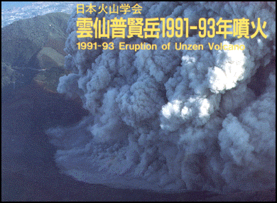
Unzen (on the Shimabara-hanto Peninsula, a two hour drive from Nagasaki) was a popular seaside and highland hot spring resort up until 1991, when a violent volcanic eruption produced a huge fire-ball-like wall of incandescent gas that killed 43 people including two of the world's most famous volcanologists (See Below). Mt. Unzen generally refers to more than 20 mountains including Mt. Fugen, and Mt. Myoken. Unzens is surrounded by the sea on three sides. "The Terraqueous Panorama" is comprised of three seas and Mt. Unzen.
Unzen — “the cloud mountain”. — is currently rated as “safe”. From the blast in 1991 there is a place where “bizarre remnants stand every few hundred meters like an outdoor installation of a sculpture park. This is where you’ll find roadside barriers wrapped around trees like the curled lid of an open sardine can, or a light-blue washing machine half-mired in petrified volcanic dust." It is possible to view Unzen in a helicopter from Nagasaki. In about 20 minutes, you can circumnavigate the aweinspiring volcano at an altitude of 2,000 meters..
Tourists can see bubbling "hells" and bath in water is piped in from these hot springs at onsens in the area. There are number of walks in the area and damage from the 1991 eruption can be seen. Some areas closed off though due to concerns about volcanic activity Mt Unzen Disaster Memorial Hall was built to commemorate the 1991 eruption. It has both in house displays and organized field trips and is involved in studying the volcano. The facility is still in the process of being set up. Unzen-Amakusa National Park is the oldest national park in Japan. It was designated as such in 1934 It is famous for it azalea blooms in the spring, colored foliage in fall and rime frost in the winter. The azalea displays are particularly awesome around Nitta Pass.
See Separate Articles MAJOR VOLCANOES AND ERUPTIONS IN JAPAN factsanddetails.com; SAKURAJIMA VOLCANO AND MAJOR ERUPTIONS IN SOUTHERN KYUSHU factsanddetails.com; MT. ASO: ERUPTIONS, CRATERS AND HIKES factsanddetails.com; VOLCANO COMPONENTS, STRUCTURE AND ACTIVITY factsanddetails.com ; TYPES OF VOLCANOES factsanddetails.com ; VOLCANIC ERUPTIONS: TYPES, PHASES AND CAUSES factsanddetails.com ; DESTRUCTIVE ERUPTIONS: LAHARS, PYROCLASTIC FLOWS AND GLACIAL BURSTS factsanddetails.com ;
Websites and Sources on Volcanoes: USGS Volcanoes volcanoes.usgs.gov ; Volcano World volcano.oregonstate.edu ; Volcanoes.com volcanoes.com ; Wikipedia Volcano article Wikipedia , Smithsonian Global Volcanism Program volcano.si.edu operated by the Smithsonian has descriptions of volcanoes around the globe and a catalog of over 8,000 eruptions in the last 10,000 years. Volcano Information in Japan: Volcano Research Center at Tokyo University eri.u-tokyo.ac.jp ; Wikipedia List of Volcanoes in Japan Wikipedia
Unzen Eruptions
Since recorded history, at least three volcanic activities occurred in the area. The eruption of Mt. Fugen that occurred during the Edo era caused the collapse of the Mt. Mayu-yama dome with the loss of 15,000 lives. Unzen, erupted catastrophically in 1792. An earthquake triggered by the eruption and the collapse of a lava dome sent an entire mountain side sliding into the ocean. The ensuing 100-meter-high tsunami submerged coastal villages, killing about 15,000 people.
Tsunamis engulfed the city of Shimabara with water reaching as far inland as the gates of the city castle. More than 43 square miles of the Shimabara peninsula was covered by water. The waves then traveled across the bay, washing away nearly 6,000 houses and 1,600 fishing boats along another 75-miles section of coastline.
Unzen, whose main peak is Mt. Fugendake, was mostly quiet for the next two centuries then it erupted suddenly on November 17, 1990. A total of 44 people died and 2,500 houses were crushed from pyroclastic flows and mudslides. The eruption wasn't declared over until May, 1996.
Trouble began in May 1991 as tons of ash piled up in the crater producing a swelling lava dome that was capable of causing a huge explosion if it collapsed. The 40,000 people in Shimabara, a coastal resort near Unzen, didn't seem too worried. One resident told Reuters, "We actually thought, 'Aha, a new tourist attraction.' We all brought our kids out to see it, things like that."
Unzen Eruption, Earthquake and Tsunami in 1792
In 1792, the collapse of one of its several lava domes of Mt. Unzen—a volcano near present-day Nagasaki in Kyushu—triggered a megatsunami that killed about 15,000 people in Japan’s worst-ever volcanic-related disaster. The volcano was most recently active from 1990 to 1995, and a large eruption in 1991 generated a pyroclastic flow that killed 43 people, including three volcanologists. [Source: History of Tsunamis in Japan, .stfrancis.edu +]
Activity from 150,000 years ago to the present has occurred at a number of sites around the volcanic complex, building four main domes at different times: the No-dake (70–150,000 years old), Myo-ken-dake (25–40,000 years old), Fugen-dake (younger than 25,000 years old) and Mayu-yama (4,000 years old) volcanic peaks. Fugendake has been the site of most eruptions during the past 20,000 years and lies about 6 kilometers (3.7 miles) from the center of Shimabara, a town in the Shimabara Peninsula of Nagasaki Prefecture, Japan. +
Unzen’s deadliest eruption occurred in 1792, with a large dacitic lava flow coming from Fugen-dake. The east flank of the Mayu-yama dome collapsed unexpectedly following a post-eruption earthquake, creating a landslide. This caused a megatsunami that reached a height of 100 metres (330 feet), and killed an estimated 15,000 people. As of 2011 it is the worst volcanic related eruption in Japan. +
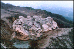
Unzen lava dome1792 Unzen earthquake and tsunami resulted from volcanic activities of Mount Unzen on May 21. The southern flank of the Mayuyama dome in front of Mount Unzen collpased, resulting in a tremendous tsunami. Many people were killed by this tsunami in Higo (Kumamoto Prefecture, situated 20 kilometers away across the Ariake Sea). The coastline of the Ariake Sea in area was dramatically changed by the event. [Source: Wikipedia +]
Towards the end of 1791, a series of earthquakes occurred on the western flank of Mount Unzen which gradually moved towards Fugen-dake (one of the Mount Unzen's peaks). In February 1792, Fugen-dake started to erupt, triggering a lava flow which continued for two months. Meanwhile, the earthquakes continued, shifting nearer to the city of Shimabara. On the night of 21 May, two large earthquakes were followed by a collapse of the eastern flank of Mount Unzen's Mayuyama dome, causing a landslide which swept through the city of Shimabara and into Ariake Bay, triggering a great tsunami. +
It is not known to this day whether the collapse occurred as a result of an eruption of the dome or as a result of the earthquakes. The tsunami struck Higo Province on the other side of Ariake Bay before bouncing back and hitting Shimabara again. Out of an estimated total of 15,000 fatalities, around 5,000 are thought to have been killed by the landslide, around 5,000 by the tsunami across the bay in Higo Province, and a further 5,000 by the tsunami returning to strike Shimabara. The waves reached a height of 33–66 feet (10–20 meters), classing this tsunami as a small megatsunami. At the Osaki-bana point Futsu town, the waves locally grew to a height of 187 feet (57 meters) due to the effect of sea bottom topography.
Lake Shirachi is a pond in Shimabara city, Nagasaki Prefecture which was created after the landslide at Mayuyama created by the inpouring of underground water. Its size was first 1 kilometers (south-north) and 300 meters to 400 meters (east to west), but the production of a water exit river made it smaller and it is now 200 meters by 70 meters. As a result of the destruction, Tsukumojima or 99 islets or rocks were distributed near Shimabara city. In the same Nagasaki Prefecture, there are 99 islands or Kuju-kushima distributed from Sasebo city to Hirado city. These islands are different from Tsukumojima.
After 1792, the volcano remained dormant until an earthquake swarm began about 20 kilometers (12 miles) underneath and 10 kilometers (6.2 miles) west of Fugendake in November 1989. Over the following year, earthquakes continued, their hypocentres gradually migrating towards the summit. The first phreatic eruptions began in November 1990, and after inflation of the summit area, fresh lava began to emerge on May 20, 1991.
Deadly Pyroclastic Flow on Mt. Unzen in 1991
On June 3rd, 1991, a violent volcanic eruption produced a pyroclastic flow — a huge fire-ball-like wall of incandescent gas — that killed 43 people including two of the world's most famous volcanologists, the French husband and wife team, Maurice and Katia Krafft.
Despite warnings to evacuate, the mountain was filled with firemen, police, scientists, journalists and farmers. The Kraffts ascended the mountain from Shimabara to film small pyroclastic flows breaking loose from the lava dome on the peak of Unzen. On June 3rd they, an American volcanologist and several members of the Japanese media walked up an eroded valley on the side of the volcano, which had just begun erupting a few days before.
Witnesses said around 4:00pm the sky turned pitch black and houses on the slopes were swallowed up by black clouds, with occasional flashes of lightning. When the pyroclastic flow (PF) occurred there was a loud crack like the sound of a lightning bolt coming from the mountain. One farmer told Reuters, "There was a rain of fire from the sky — burning ash and rock — and I was afraid the car might explode. The air smelled burned. It was hard to breath."
Noel Grove wrote in National Geographic,"Lava on the top — gray on the surface but red hot underneath — broke loose and hurled down the mountain with hurricane force. The tumbling movement energized the lava into fragmentized clouds of killer heat. The three volcanologists plus journalists, cab drivers and farmers died instantly as the heat rolled over them...A subdivision evacuated just hours before the eruption began, was wiped out by flowing mud." [Source:Noel Grove, National Geographic, December 1992]
Describing another pyroclastic flow in the valley, viewed from about two miles way, Grove wrote "a grey ball grew just below Unzen's peak. We watch it blossom into a billowing PF cloud 200 feet high and race down slope...The cloud bottomed out at the foot of the mountain, glanced off a slope, then climbing a thousand feet into the air. Later, on a helicopter ride, I saw the cloud had scorched spring foliage to a dirty brown and set homes on fire." [Source: Noel Grove, National Geographic, December 1992]
During the four years that followed the violent eruption, 200 million cubic meters of lava poured out of Unzen’s crater, creating a lava dome that increased the height of Mt. Fugendake from 1,359 meters to 1,486 meters. Although the Heisei eruption of Mt. Fugen that occurred between 1990 and 1995 caused a great deal of damage from pyroclastic flows and debris flows it created the new highest peak of Unzen — Mt. Heisei-shinzan (1483 meters).
Tourism at Unzen
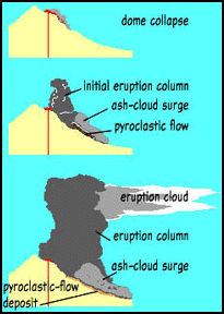
explanation of pyroclastic
flows on Unzen Mt. Unzen Visitor Center is located in the center of the Unzen Onsen hot spring district and offers easy-to-understand information and commentary on the natural environment and history of the Shimabara Peninsula, centered on Mt. Unzen. Placing a spotlight on the hot springs that are one of the attractions of Mt. Unzen, it features a range of displays on the mechanisms of hot springs and their connection to volcanoes. The annex can be used as a photo display room and a rest area. Location: Unzen 320, Obama Town, Unzen City, Nagasaki Prefecture, Tel: 0957-73-3636; Hours Open: 9:00am-5:00pm, Closed Thursdays (if coinciding with a national holiday, the next day) Open during the spring vacation period, May holidays, summer vacation period, and winter vacation period
Heisei-Shinzan Nature Center is located at the site of the former Mt. Fugen pyroclastic flow. It allows a close-up view of Mt. Heisei-Shinzan. It offers easy-to-understand overviews of the Mt. Fugen eruption, volcanic geology, the relationship between volcanoes and living beings, and more. Visitors can also directly observe how the natural environment recovers after the devastation of a volcanic disaster. Location: Kou 2683, Minami Senbongi Town, Shimabara City, Nagasaki Prefecture, Tel: 0957-63-6752; Hours Open: 9:00am-5:00pm, Closed Tuesdays (if coinciding with a national holiday, the next day), December 31, January 1
Unzen Suwano-ike Visitor Center is located along Suwano-ike Pond amid agricultural village scenery, this visitor center. It features displays on astronomy and the nature found in Satochi-Satoyama (community-based forest areas and the surrounding countryside). It is also equipped with a large-size astronomical telescope, and is actively used as a spot for celestial observation. Location: Unzen Suwano-ike, Obama Town, Unzen City, Nagasaki Prefecture, Tel: 0957-76-5010; Hours Open: 9:00am-5:00pm, Closed Wednesdays (if coinciding with a national holiday, the next day)
Websites: Government National Park Site National Parks of Japan ; Unzen Volcano Geological Survey of Japan ; Unzen Tourism Unzen Tourism ;
Accommodation Areas: Unzen Onsen, Suwano-ike Pond, Obama Onsen, Minami-Shimabara, Shimabara Onsen, Amakusa Islands' spas. Getting There: You can get to Unzen two ways by car. 1) You can drive through Saga and Nagasaki Prefectures through Obama. 2) To get from Amakusa to the Unzen volcano there is a ferryboat. The ride takes 40 minutes. Seagulls follow the ferry and dive to snatch potato chips and popcorn from people’s outstretched hands. It is about an hour’s drive between the ferry terminal and Unzen. 3) From Haneda Airport in Tokyo it takes about one hour 40 minutes to get to Nagasaki Airport. From there a prefectural bus takes about 45 minutes or a Shimatetsu Bus about 30 minutes to get to Isahaya Terminal. From there take a Shimatetsu Bus about one hour 20 minutes to get to Unzen Oyama no Johokan-mae, the bus stop closest to Mt. Unzen Visitor Center Lonely Planet Lonely Planet
Unzen-Amakusa National Park
Established in 1934, Unzen-Amakusa National Park covers an area of 282.79 square kilometers hectares (land area) in Nagasaki, Kumamoto and Kagoshima Prefectures One of Japan's first national parks, it originated as Unzen National Park and later in 1956, the Amakusa area was added and it became Unzen-Amakusa National Park. The highlight of this park is its terraqueous panorama composed of volcanic landscape of the steaming Mt. Unzen and archipelagic seascape of Amakusa. [Source: Ministry of the Environment Government of Japan]
The Unzen area is a mountainous area of the Shimabara Peninsula centered on Mt. Unzen, consisting of over 20 mountains, and it affords various panoramic views along with the seascape on three sides. Visitors can experience volcanic activity throughout the area including Jigoku Onsen (hell hot spring), the origin of the name Mt.“Unzen.” The Amakusa area is an archipelago with 120 islands and is a place to savor a varied coastline with indentations unique to a submergent coast, land-tied islands and sea cliffs, as well as corals in the sea.
Both Unzen and Amakusa areas are rich in historical sites resulted from the earliest arrival of foreign cultures in Japan, including the history of Christianity known as the Shimabara-Amakusa Rebellion. In recent years, both areas are approved as geoparks, where visitors enjoy learning geological origin and blessing of the areas, named Unzen Volcanic Area Geopark and Amakusa Geopark, respectively with the national park zone as its core.
Surrounded by the waters on three sides, the mountain trails and roadways on Mt. Unzen afford a panoramas of magnificent views. Additionally, its elegant curved silhouette captures the hearts and minds of those who gaze upon it. In the archipelagic Amakusa area, its calm sea and rough cliffs are contrastive, and the eastside area of Kami-shima Island is referred to as "Kankai (ocean view) Alps" for its sharp ridgelines rising from the sea.
Shimabara Peninsula
With Mt. Unzen in its center, Shimabara Peninsula used to be a volcanic island about 400,000 years ago. Approximately 4.3 million years ago, a volcanic island was formed by the eruption of a submarine volcano near Hayasaki, located at the south end of the peninsula and proximate to Amakusa. Subsequently, similar to the Nishino-shima Island of the Ogasawara Islands, the island grew larger by repeated eruptions. Also, about 500,000 years ago, Mt. Unzen (Unzen Volcano) was formed and its eruptive activity began. The eruption products traveled down to connect with mainland Kyushu, forming a peninsula about 400,000 years ago.
Subsequently, an east-west fault separating the Shimabara Peninsula into three areas north and south (Chijiwa Fault) was formed, and although the central part had a structure to allow continuous subsidence as compared to the northern and southern parts (Unzen Graben), the subsequent eruptions concentrated inside the graben. Obama Onsen, Unzen Onsen (Jigoku) and Shimabara Onsen, running east-west, were all formed as a result of volcanic activity in the graben. While repeating the patterns of eruptions, highly viscous magma spewed forth to create a roundly raised lava dome, and when it could not stand under its own weight, it eventually collapsed as a result of earthquake, etc. finally forming precipitous and magnificent Mt. Unzen .
On all sides of the Shimabara Peninsula and the northern shore of the Amakusa across the ocean, there is a legend of a giant named Misogoro. It is a folk story that a giant man who had a good stomach for miso formed the topography while giving a hand to farmers and fishermen. However, it is considered that the Japanese words Mizou (unprecedented) /Musou (incomparable) plus Goryo (spiritual existence), became Miso-/Musou-Goro, which we can be inferred as the spirit with unprecedented/incomparable power that is the incarnation of Mt. Unzen. This legend tells us that the help offered by Misogoro indeed represents various blessings of nature that are the result of the eruptions of Mt. Unzen.
Since ancient times, various foreign cultures have arrived and bloomed in the Shimabara-Amakusa area, the earliest in Japan, and that resulted from its location where the west side faces the open East China Sea and the east side faces the Ariake sea, the waterway to a wide-ranging area of Kyushu. The Shimabara Peninsula is known as one of the earliest areas in Japan where rice cultivation was introduced from the continent during the late Jomon period and is pockmarked with related ruins. Also, while the Buddhism was originally introduced to Japan from the continent, a renowned Buddhist priest, Gyoki, founded the Mammyo-ji Temple on Mt. Unzen in 701, which is celebrated as three dominant temple mountains of Japan along with Mt. Hiei and Mt. Koya where temples were founded later.
In the Middle Ages, Christianity was brought to both areas from Europe, bringing prosperity to the areas as a base of missionary work and Japanese trade with Spain and Portugal. Once the persecution of Christian communities began, the Unzen Jigoku became the place to torture the Christians, and in 1637, the Shimabara-Amakusa Rebellion broke out and many inhabitants barricaded themselves in Hara Castle. (It was suppressed by the army of the Edo Shogunate the following year.)
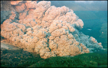
pyroclastic flow from Unzen eruption
Plants and Animals in Unzen-Amakusa National Park
The Unzen area has three vegetation zones: a deciduous broadleaf forest zone (westernmost distribution in Japan) at an elevation of 950 meters and more an evergreen broadleaf forest zone at an elevation of 600 meters and below, and a mixed forest zone at an elevation of 600 meters to 950 meters. The stretch of Mt. Fugen, (1000 meter class), is a famous place to savor the changing colors of autumn leaves, which is designated as a national natural monument, namely the autumn-colored forest around Mt. Fugen. [Source: Ministry of the Environment Government of Japan]
The representative flowers that extensively adorn Mt. Unzen are the Kyushu Azalea that colors the mountain in pink in May and the Japanese flowering dogwood that colors the mountain in white in June. Kyushu Azalea is an azalea species endemic to volcanoes in Kyushu. Because it is poisonous and cannot be eaten by cows and horses, visitors can observe splendid azalea flowers growing in clusters around the former pasturelands (Ikenohara, Nita Pass and Houbaru) and the pastureland in Tashirobaru. Both areas of Unzen and Amakusa abound with such agricultural landscapes, and terraced rice fields and farmlands add beautiful components to the terraqueous panoramas. There are terraced rice-fields in Minami-Shimabara land on Naga-shima Island
Grand Crinum Lily is a A member of the Amaryllis Family. In Japanese, it is called "hamaomoto" and is found in coastal areas. Resembles the Rohdea plant, and therefore, referred to as "Beach Rohdea." Resembles a white cloth (yu) used in Shinto devotions, and therefore, sometimes referred to as "Hama Yu." In Japanese, "hama" means "beach," so this literally means "white cloth of the beach."
Hundreds of thousands of the birds pass over the northwest of Kyushu in fall on their way to Southeast Asia. Among these is Chinese sparrowhawk (Accipiter soloensis) which breedi on the Korean Peninsula. The blue-and-white flycatcher (Cyanoptila cyanomelana) migrate to Japan in summer for breeding. Their calls can be heard in the peaks of Mt. Unzen between spring and summer. Characterized by beauty in both form and call. One of the three top songbirds of Japan.
Volcanic Sights at Mt. Unzen
Mt. Takabuto contains an observatory that affords a panoramic view of the archipelagic seascape and the scenes at dusk are especially breathtaking and famous. The sharp mountain ridges extending from Mt. Takabuto to Mt. Ryugatake are also called the Kankai Alps for its dynamic appearance rising from the sea. Mt. Heisei-shinzan, which was born as a result of the Heisei eruption of Mt. Fugen and remains a sparsely vegetated zone, is also designated as a national natural monument.
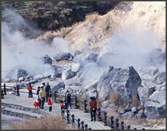
Unzen Jigoku is nestled along the hillside. Unzen Onsen, where the name Mt. Unzen was derived from, is a site where hot spring water gushes out along with volcanic gas in Unzen Jigoku. At Unzen Jigoku visitors can behold volcanic gas spewing out from underground. The vegetation, in sequence from the hot water areas, includes forked fimbry, Japanese silver grass, white form of drooping red enkianthus, and Japanese red pine. Some algae grows in the hot spring water that is heated by volcanic gas containing hydrogen sulfide. Around the Gensei moor, created by weakened and previous fumarole activity in Jigoku, there are sphagnum-covered wetlands, making it a suitable habitat for the Japanese iris and Japanese azalea.
Mt. Takaiwa at the south end of Mt. Unzen is a well-known scenic spot to enjoy a spectacular panoramic view of the mountain landscape of Mt. Unzen, the townscape in Minami-Shimabara, Ariake Sea and the Amakusa Islands. It is also the mountain that abounds with a folk story, the legend of the giant Misogoro, who is regarded as the incarnation of Mt. Unzen.
Mt. Mayu-yama at the east end of Mt. Unzen stands as if it were a folding screen in the backdrop of the Shimabara town. Honored as the blessings from a landslide that occurred during the Edo era, the area boasts its abundance of spring water and hot spring (Shimabara Onsen) along with excellent fishing grounds and harbors.
Mt. Unzen Viewed from the Sea can be done at various places. Surrounded by the waters on three sides, visitors can appreciate the elegant silhouette created by the floating Mt. Unzen over the sea from the shores and ferry routes. The silhouette appears differently depending on a direction, where visitors can totally immerse themselves in diverse panoramic views from all directions (360 degrees).
Unzen Area Sights
Unzen Onsen Town is Japan's first real resort destination for international travelers. Since the Meiji era, coupled with the opening of the Shanghai sea route connecting Shanghai and Nagasaki, Unzen was visited by many Europeans working on the continent of China as an escape from summer heat. The crest of Mt. Kinugasa-affords a full view of the Unzen Onsen Town centering around Unzen Jigoku.
Pasturing Areas are found on the north face of Mt. Unzen, Oku-Unzen/Tashirobaru, and in "Makibanosato Azuma," Oku-Unzen/Tashirobaru, Makibanosato Azuma. These are remnants of pasturelands that used to cover the stretch of Mt. Unzen
Nita Pass situated in the heart of the Shimabara Peninsula, on the upper portion of Mt. Unzen, is the home of Nita Pass Observatory, which is the base of mountaineering and the starting point of a ropeway gondola. There are the panoramic views of the sea and Mt. Unzen from a mountain trail and ropeway gondola.
Suwano-ike Pond is the largest agricultural irrigation pond on the peninsula that was built during the Edo era by utilizing the fault topography, and it is like a mirror reflecting the silhouette of Mt. Unzen. Situated adjacent to the Obama Onsen, it is surrounded by terraced farmlands spreading across the area. At the edge of the pond is a campground where visitors can interact with the nature found in Satochi, a community-based forest area, at a close distance.
Image Sources: Volcano Research Center University of Tokyo, USGS
Text Sources: New York Times, Washington Post, Los Angeles Times, Daily Yomiuri, Times of London, Japan National Tourist Organization (JNTO), National Geographic, The New Yorker, Time, Newsweek, Reuters, AP, Lonely Planet Guides, Compton’s Encyclopedia and various books and other publications.
Last updated August 2020
